
Dry Fishing Opener
By Todd Nelson
Today brings back a lot of great memories of my late father who was a fantastic fisherman! As a kid, I can remember him staying up late the night before the opener, getting the boat ready and checking all the lines and fishing poles. The day of the opener, we'd head to our favorite honey hole and slam the walleyes. I don't recall ever not having a little fish in the freezer growing up. Now, the torched has been passed down to me and my kids to make some great memories as well. See you on the water!
I am happy to report that it looks dry at the boat launch today. We are in between systems right now, so you should have no problem tackling yard chores or even sticking your nose in the garden. Make the most of the dry weather today because tomorrow looks a little wet and windy for Mom. An indoor brunch sounds good! You might even hear a few claps of thunder too.
We'll still be dealing with the cool and showery weather through early next week, but at least we'll be getting some much needed moisture. Hopefully we can continue to put a dent in the statewide drought. Some in northwestern MN still need nearly 5 to 7 inches of rain to cure the drought there.
_____________________________________
FRIDAY NIGHT: Dry and quiet. Low: 48. Winds: N 5.
SATURDAY: Dry for the fishing opener. Clouds thicken late, better chop by afternoon. High: 67. Winds: NNE 5-15
SATURDAY NIGHT: Showers and storms develop late across the southern half of Minnesota. Low: 50. Winds: NE 10-15.
SUNDAY:Breezy Mother's Day with scattered showers and storms. High: 58.
MONDAY: More wind. Cloudy with scattered showers. Flakes up north? Wake-up: 49. High: 59.
TUESDAY: Breezy and cool. Lingering shower. Wake-up: 41. High: 54.
WEDNESDAY: Better. Still cool for May. Wake-up: 41. High: 61.
THURSDAY: Getting there. Brief PM shower? Wake-up: 46. High: 66.
FRIDAY: Back to near average. Rumble of afternoon thunder. Wake-up: 49. High: 68.
________________________________________
This Day in Weather History
May 9th
1966: Hard freeze over Minnesota with temperatures in the teens as far south as Caledonia.
________________________________________
Average High/Low for Minneapolis
May 9th
Average High: 68F (Record: 91F set in 1987)
Average Low: 47F (Record: 27F set in 1966)
________________________________________
Sunrise/Sunset Times for Minneapolis
May 9th
Sunrise: 5:52am
Sunset: 8:28pm
_________________________________________
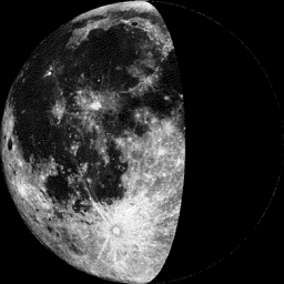
Moon Phase for May 9th at Midnight
1.2 Day Before Last Quarter
__________________________________________
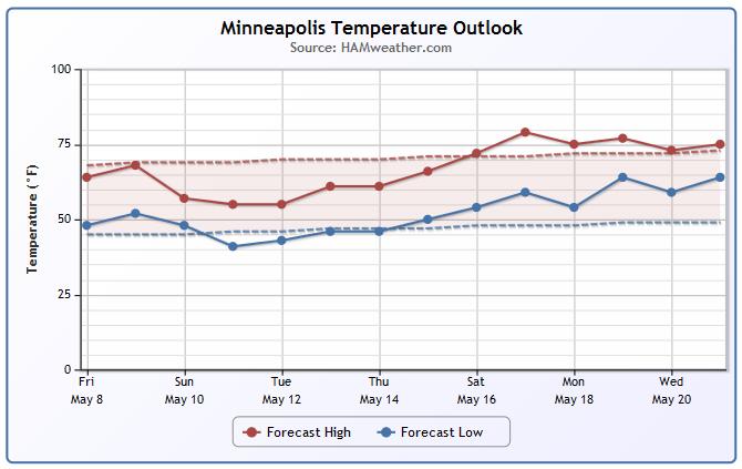
Minneapolis Temperature Trend
Cooler temperatures continue over the next several days with an even bigger cool down in store as we head into next week! In fact, some of the extended models are suggesting a little light snow across parts of northern Minnesota by early next week! The good news is that we look to gradually warm up to near or above average levels by next weekend!
__________________________________________
Saturday Weather Outlook
All things considered, Saturday will be a pretty nice day across Minnesota. While it won't be quite as warm as it was when we started the month, at least we will be dry and there will be some sunshine. However, clouds and wind speeds will continue to increase through the day.
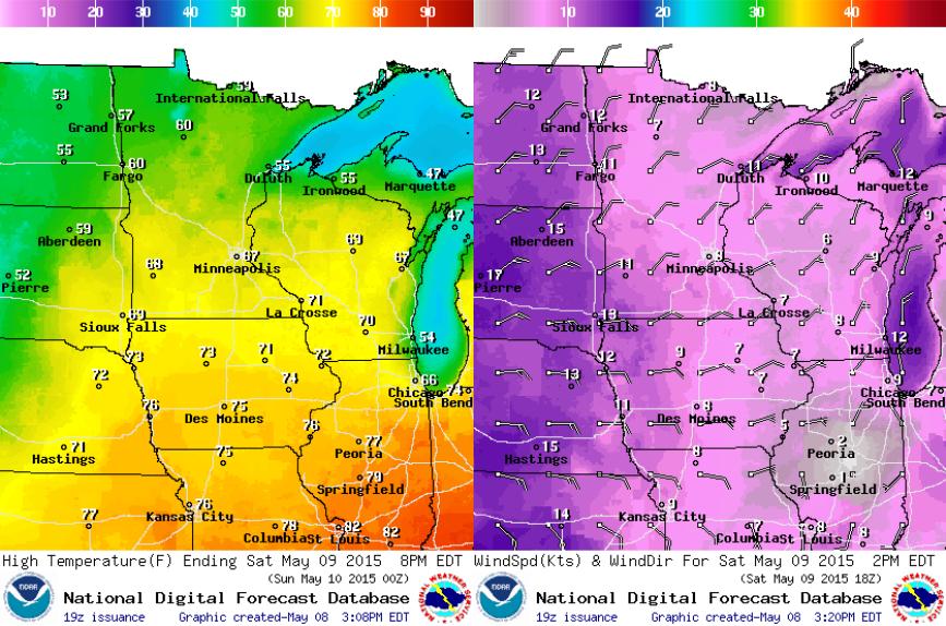
Saturday Weather Outlook
Saturday will be dry across the state, but clouds will be on the increase late in the day as shower and thunderstorm activity starts moving our way. Rain and thunder will move in as early as Saturday night with the heaviest rainfall potential moving through on Mother's Day Sunday.
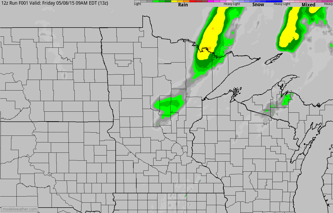
Simulated Radar
The simulated radar loop below from AM Friday through PM Sunday shows the next wave of heavier rainfall potential moving through late Saturday through Sunday. Heavy downpours look to be possible with some of the convective showers that push through on Sunday. Unfortunately, it looks a little wet and windy for Mom on Sunday.
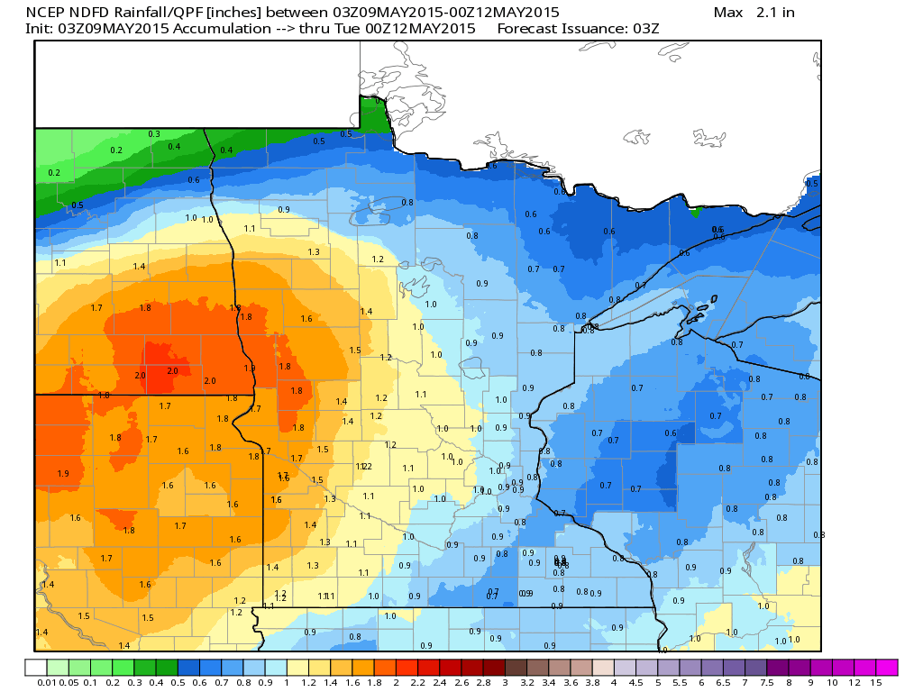
Rainfall Potential
Look at the next batch of heavy rainfall potential through moves through over the weekend. Note that Saturday will stay dry during the day, but from Saturday night through Sunday, as much as 1" to 1.5" or more may be possible.
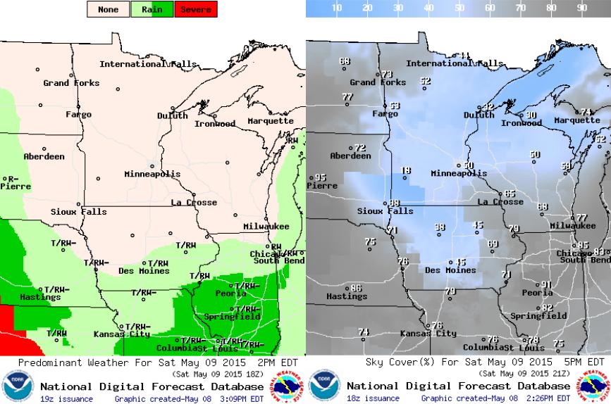
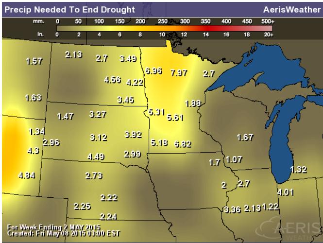
Rain Needed to End Drought
The image below suggests how much rain we would need to end the drought right now. Note that some areas across western Minnesota would need nearly 5" to 7" or more!
_________________________________________
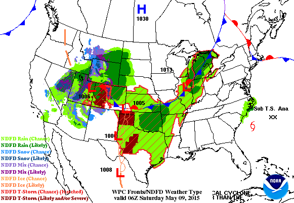
National Weather Outlook
The loop below shows our next storm system wrapping up across the middle part of the country through the weekend. Heavy rain and severe storms will be possible on it's warmer, more unsettled side, while heavy snow will be possible on the colder northwest side. Also note the storm system moving into the Carolinas. That's the first named tropical system of the 2015 Atlanctic Hurricane season. Say hello to Ana!
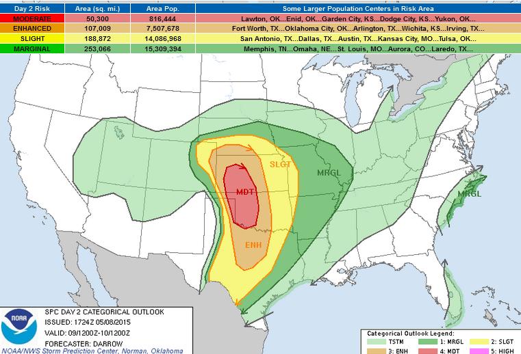
Severe Threat Saturday
..SUMMARY...
A SUBSTANTIAL SEVERE WEATHER EVENT IS POSSIBLE ACROSS PARTS OF THE
SOUTHERN AND CENTRAL GREAT PLAINS ON SATURDAY. THE GREATEST RISK
FOR INTENSE THUNDERSTORMS WILL EXTEND FROM PORTIONS OF WESTERN
KANSAS INTO WESTERN OKLAHOMA. TORNADOES...VERY LARGE HAIL...AND
DAMAGING WINDS ARE LIKELY IN THESE AREAS.
...CENTRAL AND SOUTHERN GREAT PLAINS...
LATEST SHORT-RANGE MODEL GUIDANCE CONTINUES TO SUGGEST UPPER
LOW...CURRENTLY OVER SRN CA...WILL EJECT INTO NRN AZ BY 09/12Z.
60KT+ 500MB SPEED MAX WILL TRANSLATE THROUGH THE BASE OF THE TROUGH
OVER THE SRN ROCKIES AND INCREASE TO NEAR 90KT OVER NCNTRL KS LATE
IN THE PERIOD...PER 08/12Z GFS. THIS SPEED MAX IS OF PARTICULAR
CONCERN AS IT ENCOURAGES LEE CYCLONE TO DEVELOP OVER ERN CO...THEN
DEEPEN A BIT BEFORE TRACKING NEWD ALONG THE KS/NEBRASKA BORDER BY
SUNRISE SUNDAY MORNING. FOCUSED 12HR MID-LEVEL HEIGHT FALLS ON THE
ORDER OF 90M WILL SPREAD ACROSS ERN CO INTO NEBRASKA/KS DURING
FAVORABLE PEAK IN THE DIURNAL HEATING CYCLE.
THIS STRONG FEATURE IS EXPECTED TO INDUCE CONVECTION EARLY IN THE
PERIOD ACROSS THE HIGH PLAINS AND THUNDERSTORMS...SOME OF THEM
POSSIBLY SEVERE WITH LARGE HAIL...MAY BE ONGOING FROM SERN CO INTO
WEST TX ALONG/AHEAD OF SURGING DRY LINE. CONSIDERABLE
CLOUDS/PRECIPITATION ACROSS MUCH OF CNTRL KS/CNTRL OK INTO NCNTRL TX
SHOULD LIMIT BUOYANCY AND STEEPEST LAPSE RATES ARE EXPECTED TO
DEVELOP ACROSS THE HIGH PLAINS NEAR THE DRY LINE BY AFTERNOON WHERE
STRONG SFC HEATING SHOULD BE MAXIMIZED. WHILE IT/S NOT PARTICULARLY
CLEAR HOW THE EARLY MORNING CONVECTION WILL EVOLVE...MORE CONFIDENCE
EXISTS FOR MID-LATE AFTERNOON SUPERCELL DEVELOPMENT ACROSS WRN KS
INTO NWRN OK BENEATH AFOREMENTIONED MID-LEVEL SPEED MAX/DRY SURGE.
FORECAST SOUNDINGS EXHIBIT A NARROW AXIS OF MODEST INSTABILITY WILL
DEVELOP AND SURGE NWWD ACROSS NWRN KS INTO PERHAPS EXTREME NERN CO.
WHILE STORMS THAT DEVELOP NORTH OF THE SFC LOW MAY BE LESS
BUOYANT...STRONG SHEAR FAVORS SUPERCELLS AND TORNADOES AS CLOUD
BASES SHOULD BE LOW WITHIN UPSLOPE REGIME.
WHILE LARGE HAIL/WIND ARE THE PRIMARY THREATS WITH EARLY-MID DAY
ACTIVITY THAT SPREADS ACROSS THE SRN/CNTRL PLAINS...MAIN THREAT FOR
TORNADOES WILL BE WITH DRY LINE INDUCED SUPERCELLS DURING THE
AFTERNOON/EVENING HOURS. VERY LARGE HAIL AND PERHAPS A FEW STRONG
TORNADOES ARE EXPECTED...PRIMARILY ACROSS THE MDT RISK REGION INTO
NWRN KS.
...COASTAL CAROLINAS...
TROPICAL STORM ANA IS EXPECTED TO DRIFT TOWARD THE SC COAST INTO THE
DAY2 PERIOD. SHEAR PROFILES WILL INCREASE ACROSS COASTAL PLAINS
NORTHEAST OF THE SFC LOW AND GUSTY WINDS COULD BE NOTED WITH
STRONGEST CONVECTION. HOWEVER...FORECAST SOUNDINGS ARE NOT
PARTICULARLY BUOYANT AND WIND GUSTS SHOULD REMAIN MARGINALLY SEVERE
AT BEST.
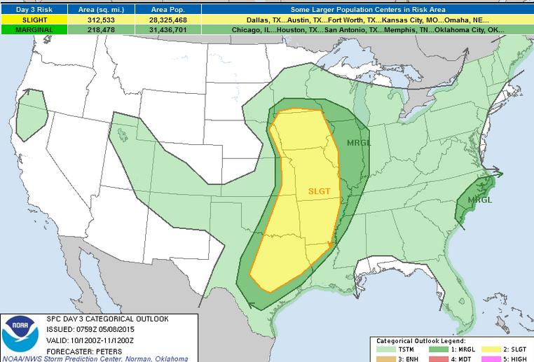
Severe Threat Sunday
...SUMMARY...
A BROAD CORRIDOR OF SCATTERED SEVERE STORMS WILL BE POSSIBLE FROM
EASTERN PORTIONS OF THE CENTRAL PLAINS TO CENTRAL AND EASTERN TEXAS
AND EXTENDING EAST THROUGH THE OZARK MOUNTAINS...MID MISSISSIPPI TO
SOUTHERN UPPER MISSISSIPPI VALLEY SUNDAY. SIMILAR TO SATURDAY...A
BRIEF TORNADO THREAT IS EXPECTED ACROSS NORTHEAST SOUTH CAROLINA AND
EASTERN NORTH CAROLINA ASSOCIATED WITH THE INLAND MOVEMENT OF
SUBTROPICAL STORM ANA.
...SYNOPSIS...
THE PROGRESSIVE FOUR CORNERS CLOSED LOW AND ATTENDANT TROUGH FROM
DAY 2 WILL REMAIN MOBILE SUNDAY...AND MAY EVOLVE INTO AN OPEN
WAVE...AS IT TRACKS FROM WRN NEB TOWARD THE UPPER MS VALLEY. THE
EQUATORWARD-EXTENDING LONGWAVE TROUGH ATTENDANT TO THE NEB CLOSED
LOW WILL ALSO LIFT NEWD THIS FORECAST PERIOD FROM THE CENTRAL/SRN
ROCKIES...AS SEVERAL MIDLEVEL IMPULSES TRANSLATE THROUGH THE BASAL
PORTION OF THE TROUGH ACROSS THE SRN PLAINS. MODELS SUGGEST...AT
LEAST...ONE SUBTROPICAL IMPULSE WILL TRACK NEWD FROM NORTH TX TO THE
UPPER GREAT LAKES THIS FORECAST PERIOD WITHIN STRENGTHENING SWLY
MID/UPPER LEVEL WINDS. AT THE SURFACE...LOW PRESSURE WILL TAKE A
SIMILAR TRACK TO THE ATTENDANT MID/UPPER LEVEL CLOSED LOW...WITH AN
EWD EXTENDING WARM FRONT SPREADING NWD INTO THE UPPER MS VALLEY AND
GREAT LAKES REGION...WHILE A TRAILING COLD FRONT ADVANCES EWD FROM
THE CENTRAL PLAINS WITH THE SWD EXTENT MAKING SLOWER MOVEMENT E/SEWD
ACROSS THE SRN PLAINS.
...ERN PORTIONS OF THE CENTRAL/SRN PLAINS...
ACTIVE WARM CONVEYOR BELT AHEAD OF THE SURFACE LOW AND AND EXTENSIVE
TRAILING COLD FRONT FROM NEB/IA SOUTH TO ERN OK AND INTO TX...SHOULD
MAINTAIN THE THREAT FOR SCATTERED SEVERE STORMS GIVEN
LIFT WITH THESE FEATURES SPREADING EAST INTO A MOIST AND UNSTABLE
AIR MASS. SOME TORNADO POTENTIAL MAY EVOLVE NEAR THE LOW CENTER AND
WARM FRONT. ALTHOUGH STRONG SWLY EFFECTIVE BULK SHEAR IS EXPECTED
TO BE LARGELY PARALLEL TO THE COLD FRONT...SHEAR VALUES EXCEEDING 50
KT SUGGEST SUPERCELLS WILL BE POSSIBLE WITH SWD EXTENT TOO...WITH
THE GREATEST POTENTIAL EXTENDING FROM NERN TX TO SRN MO WHERE SRH
VALUES ARE FORECAST TO BE STRONGER. OTHERWISE...HAIL AND DAMAGING
WINDS CAN BE EXPECTED...ESPECIALLY ACROSS THE SLIGHT RISK AREA.
MODELS TEND TO BE IN AGREEMENT THAT A CLUSTER OF STORMS WILL GROW
UPSCALE ACROSS THE SRN EXTENT OF THE SLIGHT RISK AREA AS AN MCS
DEVELOPING E/NEWD ACROSS NERN TX/ARKLATEX THROUGH THE OZARKS TO THE
MID-SOUTH WITH A CONTINUED THREAT FOR STRONG TO SEVERE STORMS SUNDAY
NIGHT.
...NERN SC/ERN NC...
A BRIEF TORNADO THREAT...SIMILAR TO SATURDAY...WILL BE POSSIBLE
WITHIN THE NRN AND NE QUADRANT OF SUBTROPICAL STORM ANA AS THIS
SYSTEM MOVE INLAND OVER NERN SC AND APPROACHES SRN NC ON SUNDAY.
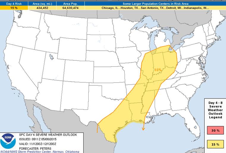
Severe Threat Monday
...DISCUSSION...
00Z ECMWF/GFS ARE IN GENERAL AGREEMENT THROUGH DAY 4 /MONDAY-MAY 11/
AS FORCING FOR ASCENT ATTENDANT TO STRONG HEIGHT FALLS SPREADS
ACROSS THE GREAT LAKES AND MID MS VALLEY THROUGH THE OH VALLEY WITH
A PROGRESSIVE MID/UPPER LEVEL TROUGH. THIS WILL SUPPORT GREATER EWD
PROGRESSION OF A COLD FRONT ACROSS THE MID MS TO OH VALLEY...WITH
THIS BOUNDARY ENCOUNTERING THE NWD EXTENT OF A MODERATELY UNSTABLE
AIR MASS. SCATTERED SEVERE STORMS WILL BE POSSIBLE SPREADING FROM
WEST TO EAST. FORCING FOR ASCENT IS EXPECTED TO BE WEAKER ALONG THE
TRAILING PORTION OF THE COLD FRONT AS IT MOVES MORE SLOWLY SWD
ACROSS THE LOWER MS VALLEY AND INTO SOUTH TX. HOWEVER...STRONGER
INSTABILITY AND STRONG SHEAR WILL SUPPORT AT LEAST A 15 PERCENT
PROBABILITY FOR SEVERE STORMS.
ON DAY 5 /TUESDAY-MAY 12/...MODELS BEGIN TO DIVERGE WITH UNCERTAINTY
IN THE FORECAST. MODELS SUGGEST INSTABILITY/SHEAR PARAMETER SPACE
WOULD BE SUFFICIENT FOR ORGANIZED STORMS ACROSS SOUTH TX...BUT LACK
OF CONFIDENCE IN ANY WEAK MIDLEVEL IMPULSES MOVING ACROSS THIS
REGION IS TOO LOW TO INCLUDE A SEVERE RISK.
BEYOND DAY 5 - ALTHOUGH MODELS TEND TO AGREE WITH THE LONGWAVE
TROUGH DEVELOPING ALONG AND INLAND OF THE WEST COAST...ELSEWHERE
THERE IS MUCH DISAGREEMENT. DESPITE THIS UNCERTAINTY EAST OF THE
ROCKIES WITH UPPER FEATURES...THE LACK OF SUBSTANTIAL INSTABILITY
DEVELOPING EAST OF THE ROCKIES INDICATES THE OVERALL SEVERE WEATHER
THREAT SHOULD REMAIN TOO LOW TO INCLUDE A 15 PERCENT AREA.
______________________________________________________
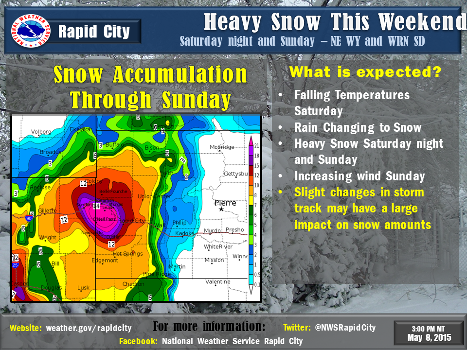
Snowfall Potential
You gotta be kidding me! Is this another April Fools joke? Here's the snowfall potential through PM Monday and note the significant blog near the Black Hills of South Dakota. Some of the recent forecasts are suggesting nearly 1ft to 2ft by early next week!
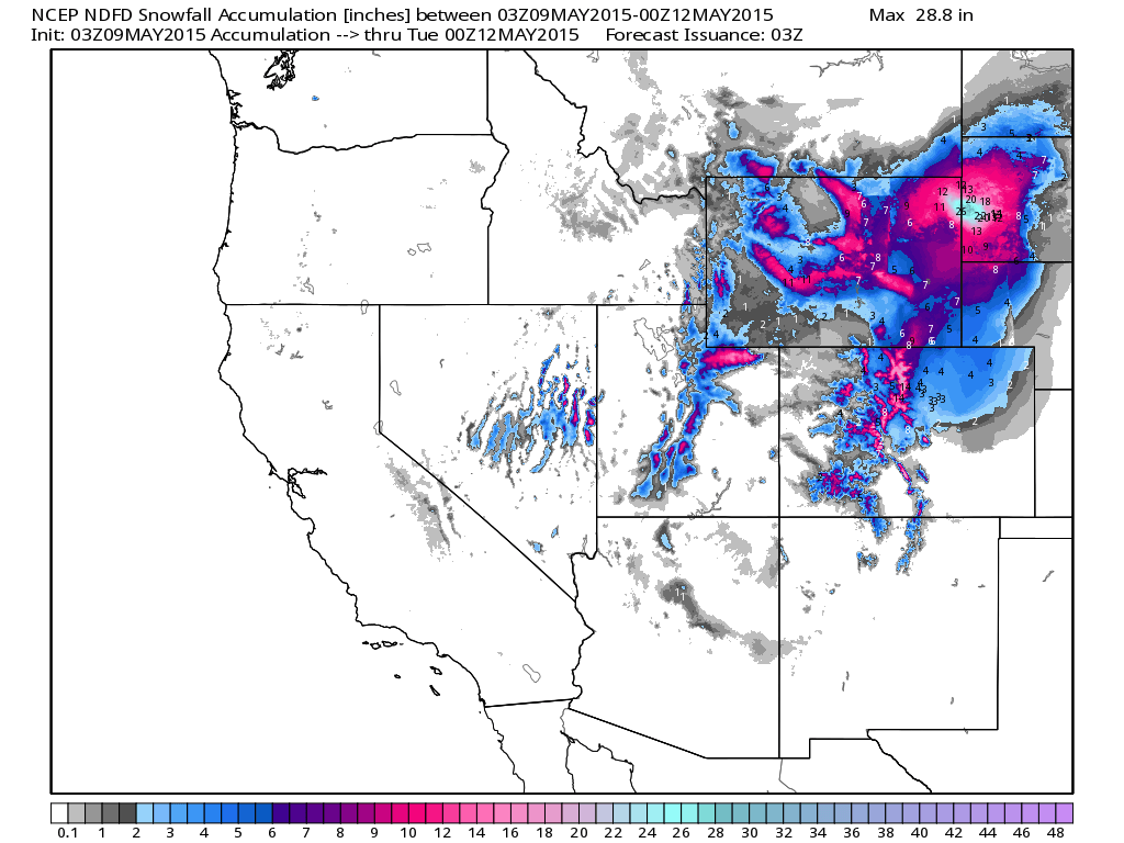
South Dakota Snow Dump
"A strong storm system will bring widespread precipitation to the area this weekend. The rain will change to snow Saturday afternoon and evening over northeast Wyoming and far western South Dakota. The snow will be heavy at times, especially Saturday night into Sunday morning. Gusty north winds will create some blowing snow Sunday on the plains east of the Black Hills. Remember, a slight change in the track of the storm may have a large impact on snow accumulations."
See more from the Rapid City, SD National Weather Service HERE:
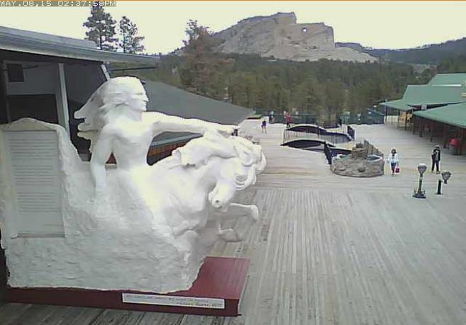
Crazy Snow at Crazy Horse?
This was the view from the Crazy Horse Viewing Deck earlier Friday. This webcam might be a good one to look at a little later this weekend with all the snow moving in!
See the current view at the Crazy Horse Viewing Deck HERE:
______________________________________________________
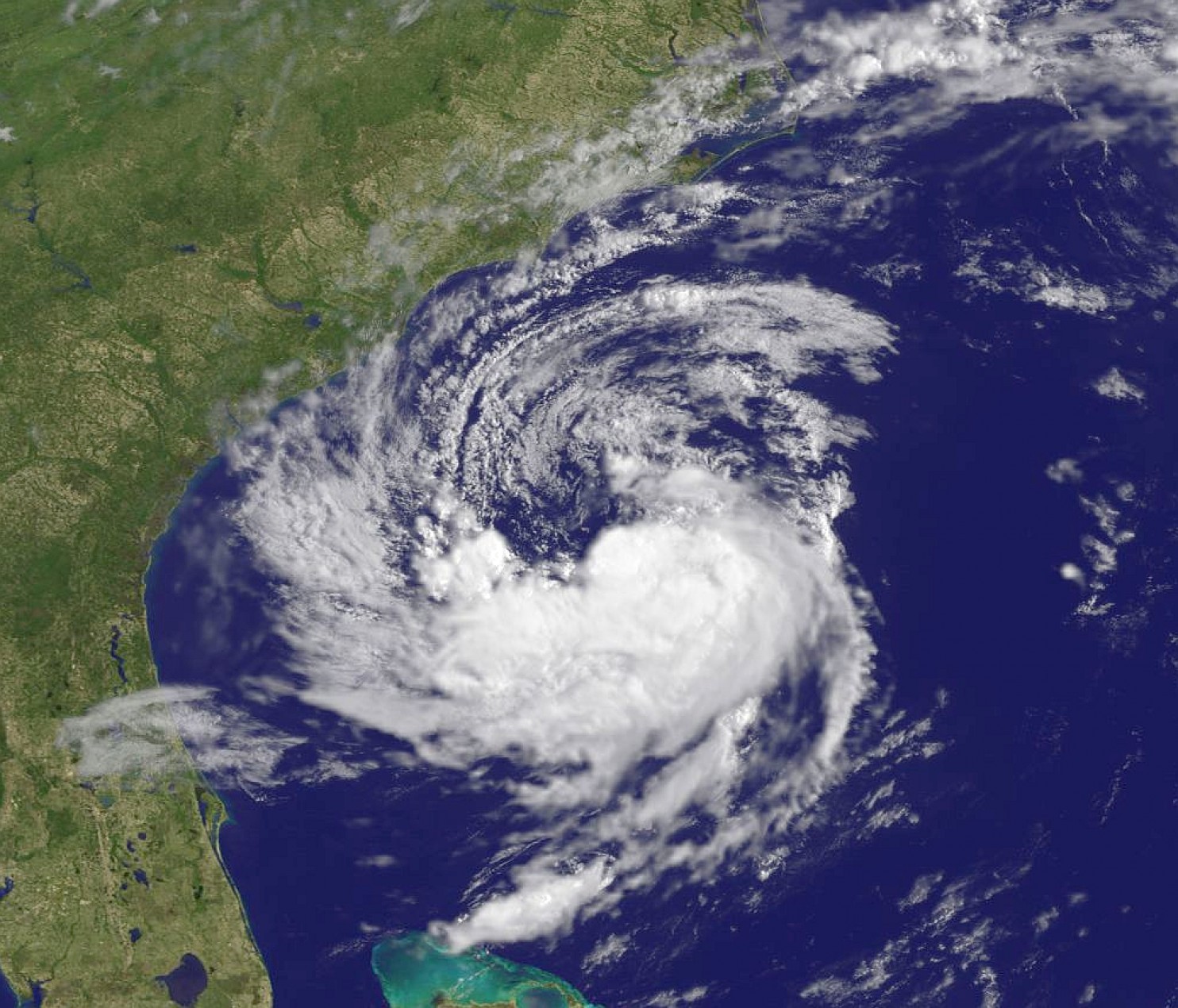
ANA in the Atlantic
"On Thursday night at 11 p.m., the National Hurricane Center began issuing advisories on a disturbance we’ve been monitoring over the past week, now Subtropical Storm Ana — the first named storm of the 2015 Atlantic hurricane season. Although “pre-season” storms occur on average every four to five years, this is the earliest first named storm since Subtropical Storm Ana formed on April 20, 2003 (quite a coincidence!)."
Read more from the WashingtonPost.com HERE:
ANA Track
The latest forecast track for ANA takes it into parts of the Carolinas over the weekend. The slow movement will keep the threat for heavy rain and gusty winds in place over the next several days.

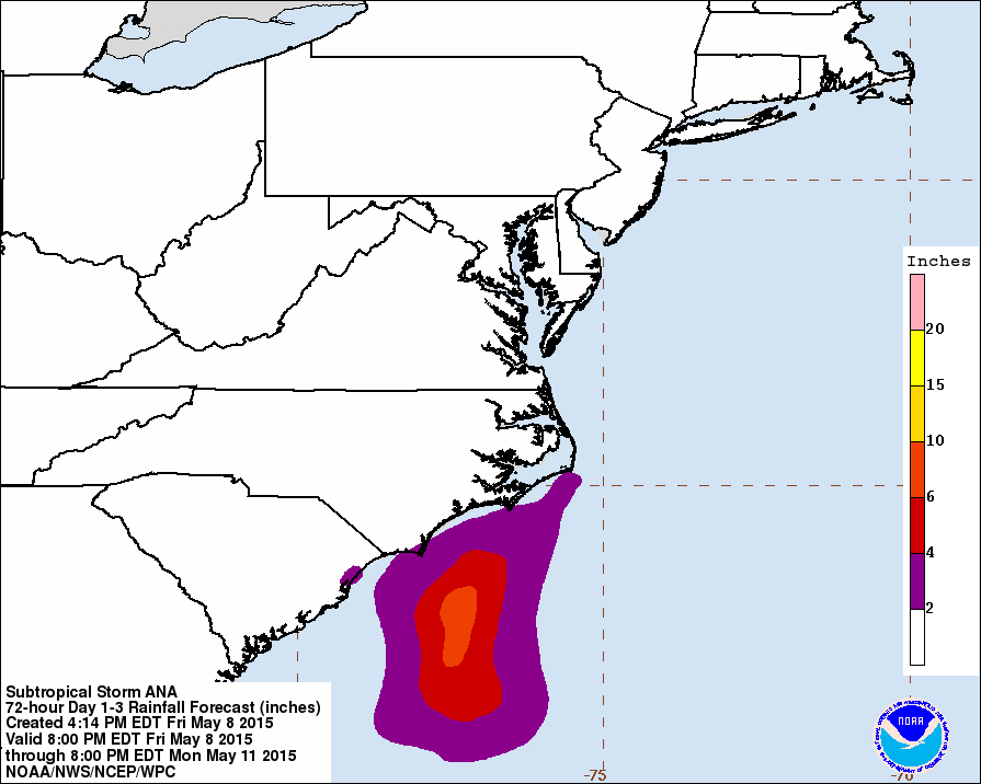
ANA Rainfall
The high end rainfall potential with Ana looks to stay just offshore through PM Monday.
_____________________________________________________
Thanks for checking in have a great rest of your weekend! Don't forget to follow me on Twitter @TNelsonWX

No comments:
Post a Comment