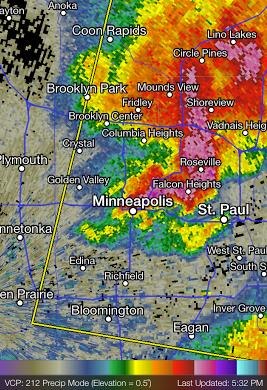
PM Sunday Thunderstorms
A strong thunderstorm pushed through parts of the metro PM Sunday with gusty winds and large hail. This was the view of the storm around 5:30pm
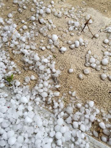
Thanks to my good friend Ryan Lutzka for the picture below. He reported quarter to near ping-pong size hail in downtown Minneapolis!! Thanks Ryan!!
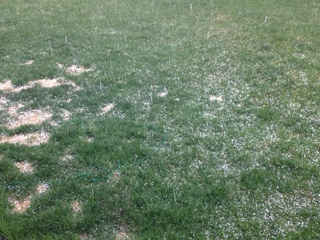
Thanks to my good friend Stephanie Chanaka Johnson out of Hanover for the picture below. A few pea-size hailstones made for an interesting evening in the northwest metro. Thanks Stephanie!
 _________________________________________
Not Bad for May
By Todd Nelson
My mother made a recent trip to Minnesota (from Phoenix) and had lots to say about our mild 70 degree and warmer weather as of late. She had great things to say about it, but she also mentioned how it was a bit cool for her taste. Don't worry, I defended our weather!
Minnesotans, no doubt, make the most of our brief and fleeting summer-like weather. Boat launches, garden stores and city compost sites were buzzing this weekend. Just the way I like it. It's funny how the population close to home seems to double when the weather warms. I was finally able to greet my neighbors again since late last fall when the snow starting flying.
The average high for this time of year is still in the mid 60s, we've been seeing highs more representative of mid June! May can be a fickle month. I remember Mother's Day/Minnesota Fishing Opener weekends that have featured wintry precipitation and the threat of severe weather.
This Wednesday will be the 50th anniversary of the 1965 super-outbreak, where 6 tornadoes touched-down near the Twin Cities metro, four of which were rated F4s!
Thankfully no super-outbreaks are forecast this year, but much needed rain is!
_________________________________________
SUNDAY NIGHT: Thundershower possible early across southeastern MN. Low: 51. Winds: N 5-15
MONDAY: Mild with more sun. High: 71. Winds: N 5-10
MONDAY NIGHT: Clouds increase. Chance of a shower or thunderstorm late across far southern MN. Low: 50. Winds: E 5mph
TUESDAY: Clouding up, showers and storms arrive late, mainly in southern MN. High: 64. Winds: E 10-15
WEDNESDAY: Breezy. Rain with spotty thunder. Wake-up: 53. High: 73
THURSDAY: Scattered showers and storms. Wake-up: 60. High: 74
FRIDAY: Turning breezy and cooler. Less wet. Wake-up: 59. High: 71.
SATURDAY: Cooler. Looks dry with more sun. Wake-up: 52. High: 66.
SUNDAY: Clouds increase. Rain returns late. Wake-up: 49. High: 64.
____________________________________________
This Day in Weather History
May4th
1926: From winter to summer in one day. Morris rose from 32 to 89.
___________________________________________
Average High/Low for Minneapolis
May 4th
Average High: 66F (Record: 91F set in 1952)
Average Low: 45F (Record: 22F set in 1967)
___________________________________________
Sunrise/Sunset Times for Minneapolis
May 4th
Sunrise: 5:58am
Sunset: 8:22pm
___________________________________________
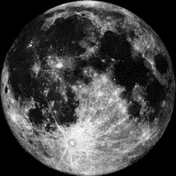
Moon Phase for May 4th at Midnight
1.1 Day After Full Flower Moon
_____________________________________________
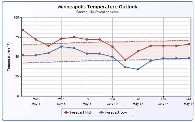
Minneapolis Temperature Trend
After a very mild weekend, we take a bit of a dip into the week ahead. Temperatures will still be more June-like with highs in the 70s to near 80F, but a sharp front looks to sneak through early next week with highs dipping into the 60s to near 50F.
_____________________________________________
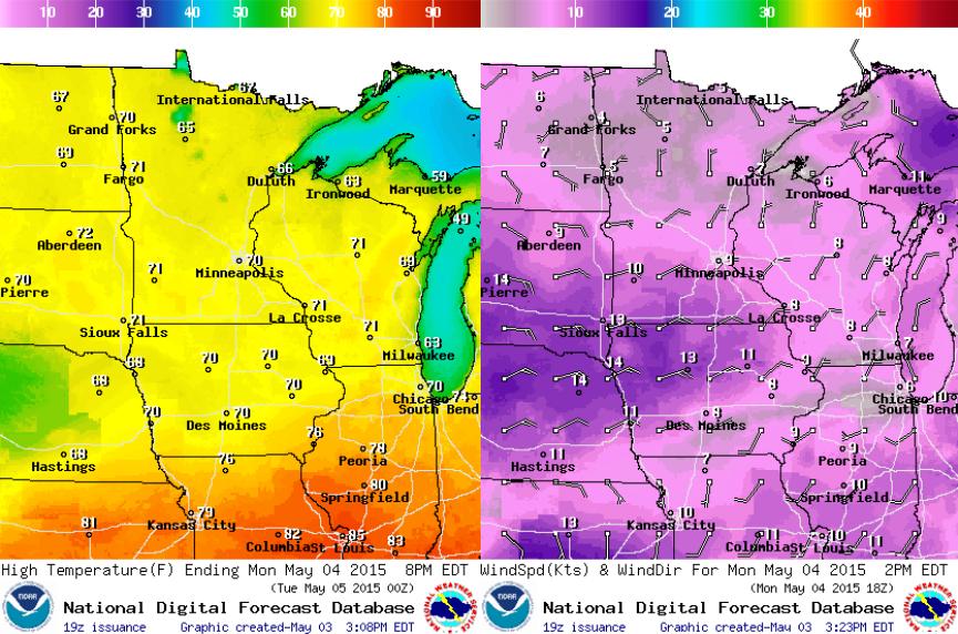
Monday Temperature Outlook
Post front temperatures will dip into the 60s and 70s across the state, but we will still be above average. Winds post front will pick up a little out of the north-northeast.
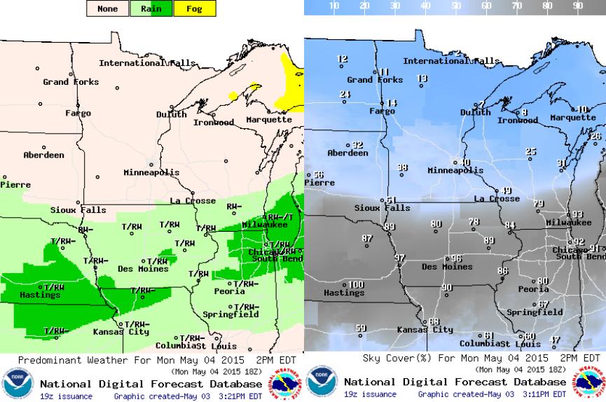
Monday Weather Outlook
After a few showers and storms across the southern half of the state PM Sunday, weather conditions on Monday look drier and sunnier. The front will push south of the Minnesota/Iowa border and keep shower and thunderstorm chances there.
____________________________________________
Simulated Radar
After a few showers and storm on Sunday afternoon/evening across the southeastern part of the state, weather conditions will improve post front on Monday. The next best chance of redeveloping showers and storms will be later Tuesday into midweek.

_________________________________________________
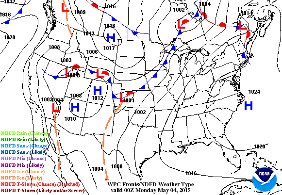
National Weather Outlook
The front that pushes through the Upper Mississippi Valley late Sunday looks to stall across parts of the Midwest early this week. Note the heavier moisture continuing across the middle part of the country through the early week time frame.
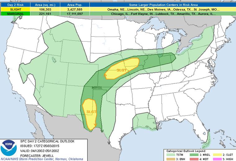
Severe Threat Monday
...SUMMARY...
A FEW SEVERE THUNDERSTORMS ARE EXPECTED MONDAY AFTERNOON AND EVENING
FROM NORTHERN KANSAS INTO IOWA AS WELL AS ACROSS SOUTHEASTERN NEW
MEXICO INTO WESTERN TEXAS.
...SYNOPSIS...
THE BASE OF A LOW-AMPLITUDE UPPER TROUGH WILL MOVE ACROSS THE GREAT
LAKES AND NERN STATES WITH PRIMARY SURFACE LOW OVER QUEBEC. A
STATIONARY FRONT WILL TRAIL SWWD FROM LOWER MI INTO THE CNTRL
PLAINS...WITH SLY SURFACE FLOW CONTINUING TO GRADUALLY MOISTEN AND
DESTABILIZE THE AIR MASS TO THE S WITH 50S TO NEAR 60 F DEWPOINTS.
TO THE S...A LOWER LATITUDE SHORTWAVE TROUGH WILL DEVELOP EWD ACROSS
AZ AND NM WITH SWLY FLOW AND HEIGHT FALLS GRADUALLY SPREADING INTO
THE SRN PLAINS LATE IN THE PERIOD. BOTH THE STATIONARY FRONT AS WELL
AS LIFT ASSOCIATED WITH THE SRN WAVE WILL RESULT IN A RISK OF
SCATTERED SEVERE STORMS FROM LATE AFTERNOON INTO THE EVENING.
...SERN NM INTO WRN TX...
SELY SURFACE WINDS WILL MAINTAIN A MOIST AIR MASS AS HEATING MIXES
OUT THE CAPPING INVERSION ACROSS SERN NM AND SWRN TX. SCATTERED
STORMS WILL DEVELOP WHERE DEEP MIXING OCCURS ON THE WRN FRINGE OF
THE HIGHER DEWPOINTS. VEERING WINDS WITH HEIGHT STRONGLY FAVOR
SUPERCELLS...AND A STORM OR TWO MAY PRODUCE HAIL IN THE 1.75 TO 2.00
INCH RANGE. STORMS SHOULD PERSIST INTO THE EVENING INTO WRN TX WITH
THE SUPPORT OF THE UPPER TROUGH.
...CNTRL KS INTO CNTRL IA...
ISOLATED EARLY-DAY STORMS MAY BE ONGOING NEAR THE FRONT OVER NEB AND
IA BUT THE GREATEST THREAT WILL EXIST NEAR THE PEAK HEATING HOURS
WHEN INSTABILITY IS STRONGEST. MID AND UPPER LEVEL WINDS ARE
FORECAST TO BE RELATIVELY WEAK...BUT PERSISTENT LIFT ALONG THE
BOUNDARY AS WELL AS FAVORABLE TIME OF DAY AND AN INCREASING SLY
LOW-LEVEL JET WILL ALL WORK TO SUPPORT A FEW STRONG TO SEVERE
CLUSTERS OF STORMS ACROSS KS...NEB...IA AND NRN MO. BOTH LARGE HAIL
AND LOCALIZED SEVERE WIND GUSTS WILL BE POSSIBLE. MORE
ISOLATED/MARGINAL ACTIVITY IS EXPECTED EWD ALONG THE FRONT FROM IL
INTO OH.
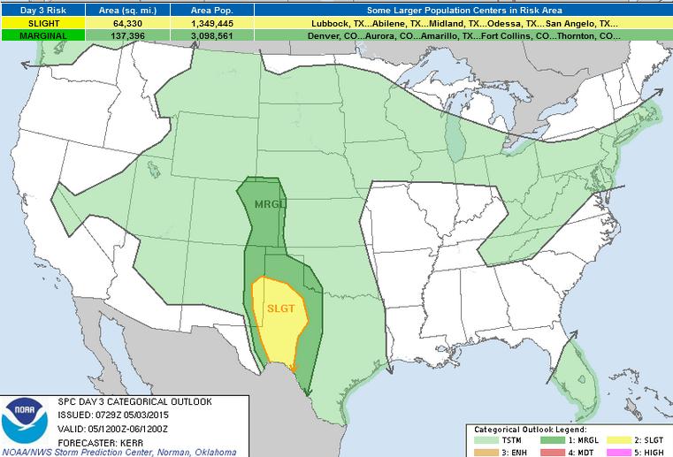
Severe Threat Tuesday
...SUMMARY...
SCATTERED SEVERE STORMS ARE POSSIBLE TUESDAY ACROSS PARTS OF THE
SOUTHERN HIGH PLAINS.
...SYNOPSIS...
CONSIDERABLE SPREAD PERSISTS WITHIN THE ENSEMBLE OUTPUT OF THE
VARIOUS MODELS CONCERNING THE EVOLUTION OF THE UPPER FLOW NEAR THE
PACIFIC COAST DURING THIS PERIOD. IN GENERAL...THOUGH...IT DOES
APPEAR THAT UPPER TROUGHING MIGRATING INTO THE PACIFIC
NORTHWEST...WITHIN THE STRONGER BELT OF MID-LATITUDE
WESTERLIES...WILL ELONGATE ALONG A NORTH-SOUTH AXIS. GUIDANCE
SUGGESTS THAT THIS WILL OCCUR AS ONE SIGNIFICANT IMPULSE PIVOTS
AROUND THE EASTERN PERIPHERY OF THE EMBEDDED CLOSED LOW...SUPPORTING
REDEVELOPMENT OF THE CENTER OF CIRCULATION EAST NORTHEASTWARD INTO
ALBERTA. AT THE SAME TIME ANOTHER SIGNIFICANT IMPULSE IS FORECAST
TO BEGIN DIGGING SOUTHWARD...ACROSS OREGON/NORTHERN
CALIFORNIA...INTO LARGER SCALE TROUGHING WITHIN A WEAKER SOUTHERN
BRANCH OF MID-LATITUDE WESTERLIES. AS THIS OCCURS...AN IMPULSE
WITHIN THE LATTER STREAM IS FORECAST TO GRADUALLY APPROACH THE
SOUTHERN CALIFORNIA AND BAJA COAST...COMING INCREASINGLY IN PHASE
WITH THE SUBTROPICAL JET...WHILE A MORE PROMINENT DOWNSTREAM IMPULSE
PIVOTS NORTHEAST OF THE SOUTHERN ROCKIES.
IN RESPONSE TO THESE DEVELOPMENTS...SURFACE TROUGHING IS EXPECTED TO
DEEPEN THROUGH MUCH OF THE HIGH PLAINS. ASSOCIATED STRENGTHENING OF
SOUTHERLY LOW-LEVEL FLOW TO THE EAST WILL CONTRIBUTE TO FURTHER
MOISTENING...ACROSS AND NORTH OF THE LOWER RIO GRANDE VALLEY.
HOWEVER...IN THE WAKE OF DOWNSTREAM UPPER TROUGHING...CONTINUING TO
EVOLVE ACROSS THE FLORIDA PENINSULA AND CARIBBEAN...RICHER TROPICAL
BOUNDARY LAYER MOISTURE IS EXPECTED TO REMAIN CONFINED TO MEXICAN
GULF COASTAL AREAS...AND PERHAPS ADJACENT DEEP SOUTH TEXAS PORTIONS
OF THE RIO GRANDE VALLEY.
...CENTRAL/SOUTHERN HIGH PLAINS...
CONSIDERABLE CONVECTIVE DEVELOPMENT MAY BE ONGOING ACROSS PARTS OF
THE TEXAS SOUTH PLAINS EARLY TUESDAY...IN RESPONSE TO FORCING FOR
UPWARD VERTICAL MOTION DOWNSTREAM OF THE LEAD SOUTHERN STREAM
IMPULSE. A LOW-LEVEL BAROCLINIC ZONE GENERATED BY CONVECTIVE
OUTFLOW/DIFFERENTIAL SURFACE HEATING MAY THEN PROVIDE A FOCUS FOR
RENEWED AFTERNOON AND EVENING THUNDERSTORM ACTIVITY...WHILE THE
DRYLINE PROVIDES ANOTHER FOCUS FOR STORM INITIATION ACROSS THE
CENTRAL AND SOUTHERN HIGH PLAINS.
ALTHOUGH SUBSTANTIVE STABILIZATION OF MID-LEVEL LAPSE RATES MAY HAVE
OCCURRED ACROSS MUCH OF THIS REGION BY EARLY TUESDAY...IT DOES
APPEAR THAT DAYTIME HEATING ACROSS THE HIGHER TERRAIN...IN
CONJUNCTION WITH MID-LEVEL COOLING ASSOCIATED WITH THE UPPER TROUGH
/AND CONTINUED LOW-LEVEL MOISTENING/...WILL CONTRIBUTE TO WEAK TO
MODEST DESTABILIZATION BY LATE AFTERNOON. STRONGEST INSTABILITY IS
EXPECTED TO DEVELOP SOUTH AND WEST OF THE OUTFLOW BOUNDARY INTO THE
DRYLINE ACROSS SOUTHWEST TEXAS AND EASTERN NEW MEXICO...WHERE
VEERING OF 30-40+ KT FLOW TO AN INCREASINGLY WESTERLY COMPONENT IS
EXPECTED TO YIELD THE STRONGEST VERTICAL SHEAR. A FEW SUPERCELLS
APPEAR POSSIBLE...ACCOMPANIED BY THE RISK FOR SEVERE HAIL AND
LOCALLY STRONG WIND GUSTS. STORMS CROSSING...OR FORMING ALONG...THE
OUTFLOW BOUNDARY MAY BE ACCOMPANIED BY THE RISK FOR TORNADOES.
___________________________________________________
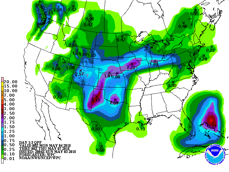
3 Day Precipitation Outlook
The front responsible for our PM Sunday shower and thunderstorm activity will being shifting south through the early week time frame. Heavier pockets or rain will be possible from the Texas and Oklahoma Panhandle to parts of the Midwest.
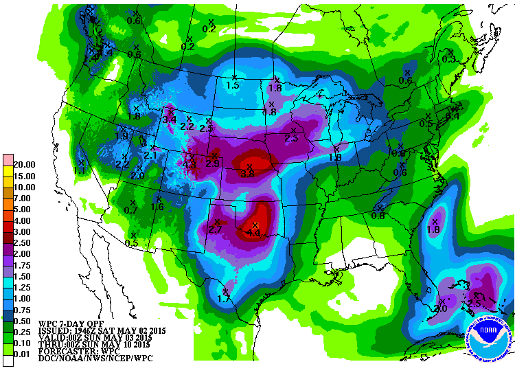
7 Day Precipitation Outlook
The extended forecast through PM Saturday suggests heavier rainfall potential across parts of the Plains. Upwards of 2" to 4" may be possible through the week.
______________________________________________________
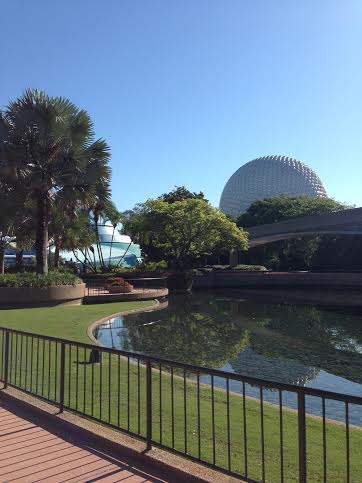
Thanks to Wade Weidner for the picture below from The Epcot Center at Disney World in Florida. Sure looks like a nice spot to be at right now! Have fun and say hi to Mickey and Minnie for me will you?
Thanks for checking in and have a great week ahead! Don't forget to follow me on Twitter @TNelsonWX

No comments:
Post a Comment