
PM Puddles
By Todd Nelson
I am a father of a 5 and a 3 year old and feel like I've been roped into singing "Rain, rain, go away" far too many times over the past couple of weeks. It can be far more interesting around the house when your kids can't get outside to blow off some steam. While the rain is helping with the current drought situation, it's also threatening my sanity. Any parents with little ones may feel my pain. Deep breaths!
Expect lots of PM puddles as a weak storm system slides through the region today. It'll be a soggy start to your Friday, but we should clear out a bit to at least see a little sunshine by the end of the day. Our next storm system moves in this weekend with a better chance of strong to possibly even severe thunderstorms late Saturday into Sunday. The Storm Prediction Center has already highlighted parts of the state as a potential risk for stronger storms, so keep up to date with latest forecasts as we approach the weekend.
Extended forecasts suggest that with today's rain coupled with that over the weekend, we could be looking at nearly 1 to 2 inches of
__________________________________
WEDNESDAY NIGHT: Breezy. Increasing clouds. Low: 50. Winds: SE 10-15.
THURSDAY: Rain. Lots of PM puddles. High: 57. Winds: SE 15.
THURSDAY NIGHT: Rain early, then mostly cloudy. Low: 51. Winds: SE 5-10 turning NNE
FRIDAY: Soggy start. Warme and drier afternoon. High: 72.
SATURDAY: Breezy and mild. Strong PM storms. Wake-up: 54. High: 76.
SUNDAY: Scattered showers and storms. A few heavy downpours. Wake-up: 63. High: 75.
MONDAY: Quickly drying. Cooler temps. Wake-up: 50. High: 64.
TUESDAY: Still dry, nothing rough. Wake-up: 42. High: 66.
WEDNESDAY: Spotty PM shower or storm. Wake-up: 50. High: 67.
____________________________________
This Day in Weather History
May 14th
1935: Minneapolis sets a record high temperature of 95 degrees.
____________________________________
Average High/Low for Minneapolis
May 14th
Average High: 69F (Record: 98F set in 2013)
Average Low: 48F (Record: 32F set in 1907)
____________________________________
Sunrise/Sunset Times for Minneapolis
May 14th
Sunrise: 5:47am
Sunset: 8:34pm
_____________________________________
Moon Phase for May 14th
2.9 Days Before New Moon
____________________________________
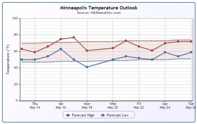
Minneapolis Temperature Trend
Cloudy, wet weather on Thursday will make for another cooler than average day. In fact, temperatures will be nearly 10° below average for some as most of us struggle to get to 60°. The good news is that we look to warm up to near or above average levels this weekend. Unfortunately, it appears that we will also have some unsettled weather as well. Shower and thunderstorm chances look to be on the rise with a few strong/severe storms possible close to home. Stay tuned!
___________________________________
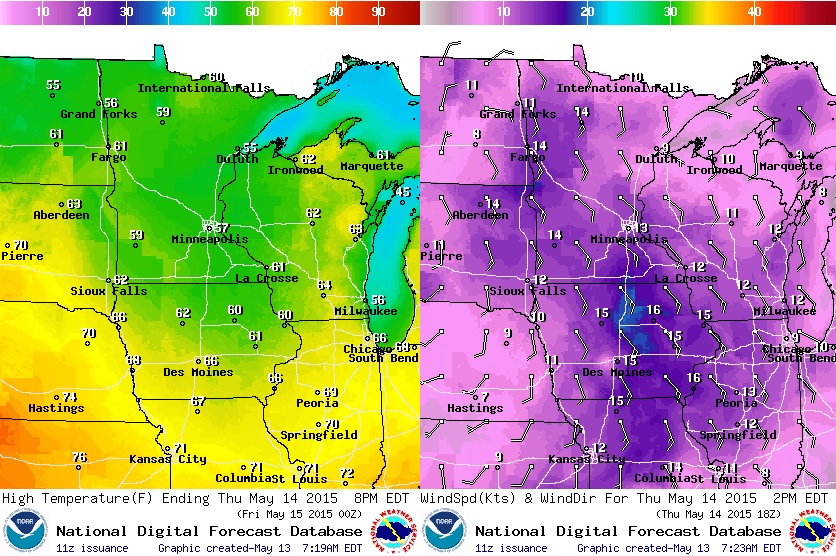
Thursday Weather Outlook
Thursday will be a cool and somewhat breezy day across the region as an area of low pressure slides through the region. Most Minnesota locations will only warm into the 50s.
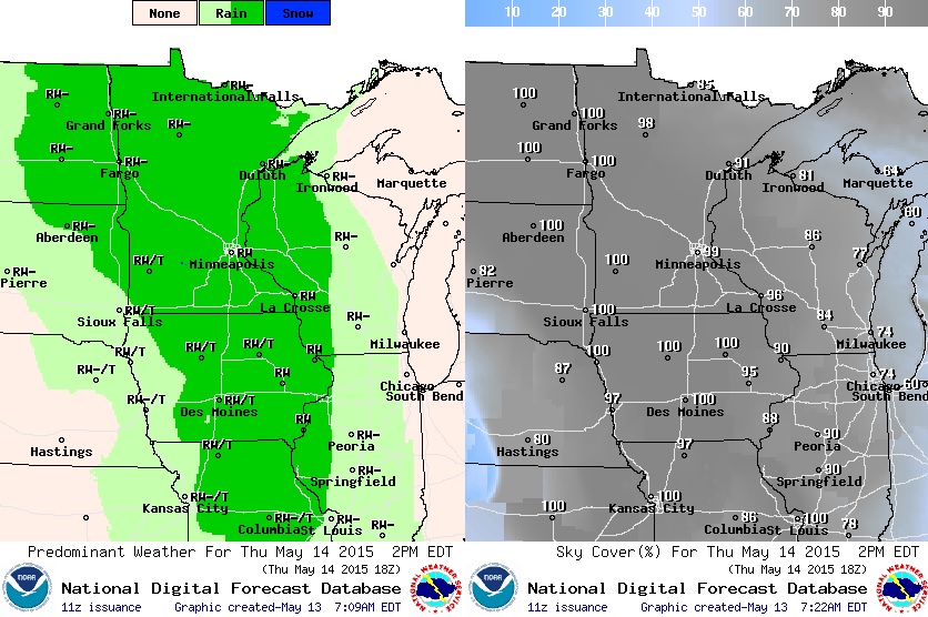
Thursday Weather Outlook
Outdoor plans for Thursday? You might want to have a plan B. It's going to be quite soggy across the entire region as an area of low pressure slides north through the region. It doesn't appear that we'll have any significant heavy downpours, but a steady light to moderate rain could give way to several PM puddles.
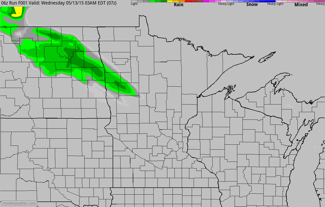
Simulated Radar
Here's the simulated radar from early Wednesday through the end of the week and note the more widespread are of rain moving through the region on Thursday. While it looks like a fairly soggy day, we're not expecting any severe weather!
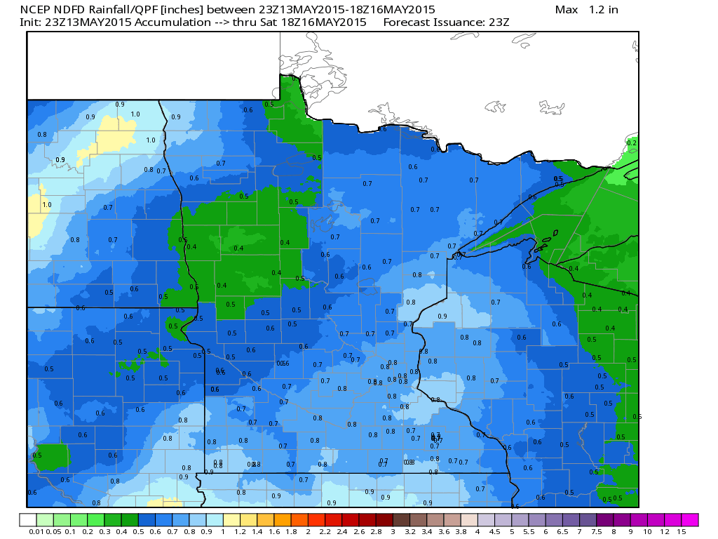
Rainfall Potential
We've certainly been getting some much needed rainfall as of late and it appears that more heavy rainfall will be on the way Thursday and again this weekend. The image below suggests the rainfall potential through midday Saturday. Note that a few areas may see as much as 0.50" to 1".
_______________________________________
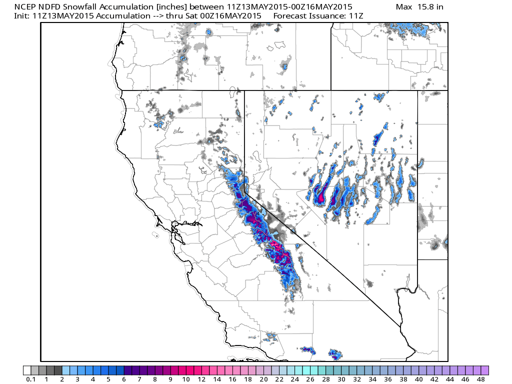
California Snow Potential
Snow
will be falling across parts of the Sierra Nevada Range later this week
with as much as 6" to 12" possible through PM Thursday. Interestingly,
the storm system responsible for the California snow will also be the
same storm system responsible for our weekend rain and thunder chances
close to home.
* HAZARD TYPE...SNOW.
* SNOW ACCUMULATIONS...4 TO 6 INCHES AT 6000 FEET WITH LOCAL AMOUNTS UP TO 12 INCHES NEAR THE CREST.
* TIMING...SNOW SHOWERS BEGINNING LATE TONIGHT. HEAVY SNOW SHOWERS ARE POSSIBLE THURSDAY AFTERNOON AND EARLY THURSDAY EVENING.
*
IMPACTS...BIGGEST CONCERN WILL BE FOR HIGHWAY 120 OVER TIOGA PASS AND
TRAVELERS USING THIS HIGHWAY. ALSO FOR HIGHWAYS 140 AND 41 IN YOSEMITE
PARK...AND HIGHWAY 168 NEAR HUNTINGTON LAKE. BACK COUNTRY CAMPERS AND
HIKERS WILL LIKELY SEE RAPID CHANGES IN THE WEATHER.
* TEMPERATURES...IN THE UPPER 20S TO LOWER 30S.
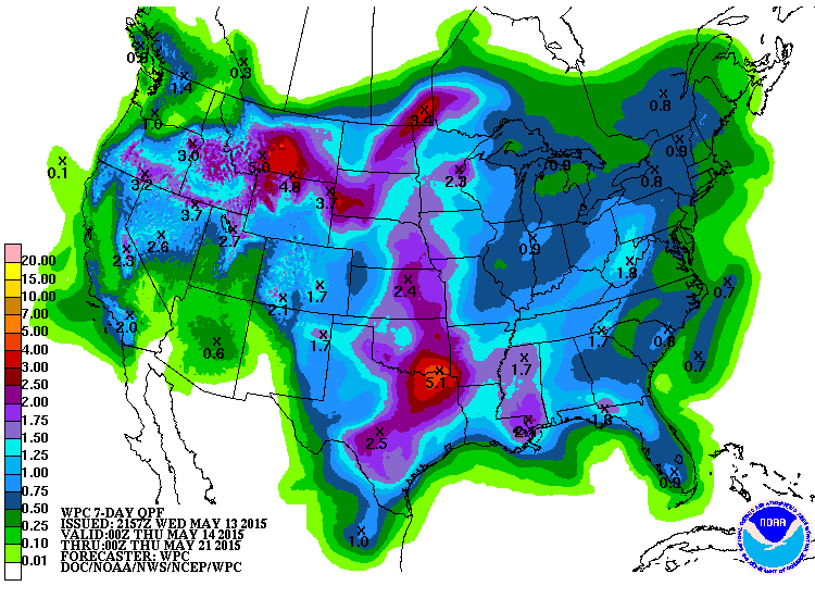
7 Day Precipitation Outlook
When it rains, it pours. According to NOAA's HPC, the 7 day precipitation forecast suggests an additional 3" to nearly 6" of rain possible for parts of the Central U.S.. The heaviest moisture looks to be across parts of Texas and Oklahoma, where as much as 6" to 10" of rain has already fallen over the last 7 days!
___________________________________
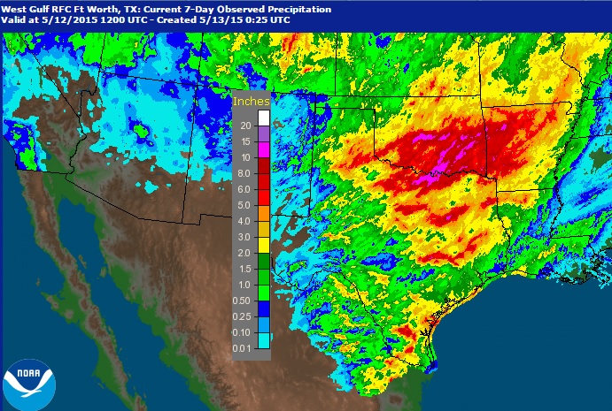
Rainfall Past 7 Days
Radar estimates suggest that parts of Texas, Oklahoma and Arkansas have seen nearly 6" to 10" over
the last 7 days. With more heavy rain in the forecast over the next 5
to 7 days, more flooding will be likely in some of these areas.
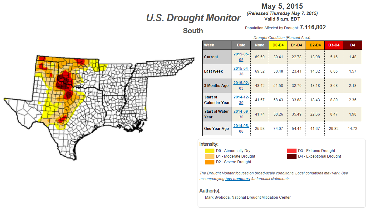
Southern Drought
The image below from the U.S. Drought Monitor from May 5th showed several locations across parts of Texas and Oklahoma under severe and exceptional drought concerns. It'll be interesting to see the latest drought update when that gets released later this week.
___________________________________
National Weather Outlook
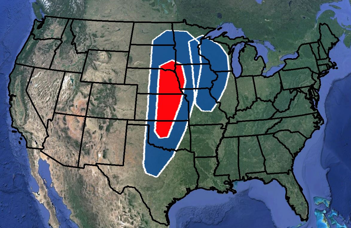
The somewhat soggy and unsettled weather pattern will continue across the western half of the country through the end of the week. The first area of concern will be a weaker area of low pressure moving north through the middle part of the country through Thursday, while the second area of concern takes shape over the Western U.S. through the second half of the week. The first area of low pressure will be responsible for mainly just pockets of heavier rain, while the threats from the second storm will range from snow across the western mountains to late week/weekend severe storms and heavy rain across the Central U.S.
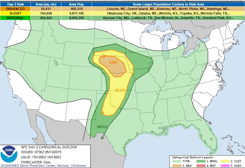
Severe Threat Ramping Up
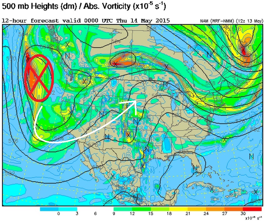
We’re keeping an eye on the severe weather potential later this week/weekend as a fairly vigorous area of low pressure looks to develop in the Western U.S.. The image below shows the current area of energy/interest just west of the Pacific Northwest.
Increasing Instability
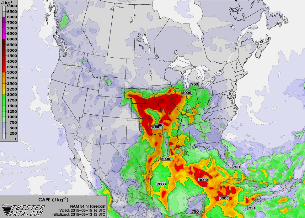
As the storm system develops over the next several days, it appears weather conditions on the eastern side of the storm will begin to become increasingly more unstable. The images below show the available energy (CAPE) for Friday and Saturday afternoon. Note that the more intense oranges and reds, which indicates a fairly substantial amount of energy available for storms to develop and feed from.
CAPE Friday 1pm CT
Severe Threat Friday
...SUMMARY...
SEVERE STORMS ARE EXPECTED TO DEVELOP FRIDAY AFTERNOON AND EVENING OVER
THE CENTRAL PLAINS WITH MORE ISOLATED DEVELOPMENT POSSIBLE FARTHER
SOUTH ACROSS WESTERN PORTIONS OF THE SOUTHERN PLAINS. ...SYNOPSIS...
MODEL CONSENSUS IS THAT A LEAD SHORTWAVE TROUGH WILL EJECT NEWD THROUGH
THE CNTRL PLAINS FRIDAY IN ADVANCE OF A SYNOPTIC TROUGH THAT WILL MOVE
SLOWLY EWD THROUGH THE GREAT BASIN AND CNTRL/SRN ROCKIES. AT THE SFC A
LEE LOW WILL PERSIST OVER ERN CO AND SHIFT SLOWLY EWD DURING THE DAY
WHILE A DRYLINE SHARPENS FROM WRN KS AND WILL EXTEND SWD THROUGH WRN TX.
A WARM FRONT WILL EXTEND EWD FROM THE LOW THROUGH SRN NEB AND SRN IA
EARLY FRIDAY AND LIFT SLOWLY NWD DURING THE DAY. ...NRN KS THROUGH NEB
AND SRN SD... AREAS OF ELEVATED CONVECTION MAY BE ONGOING OVER NEB EARLY
FRIDAY WITHIN ZONE OF ISENTROPIC ASCENT NORTH OF WARM FRONT. THIS
ACTIVITY SHOULD SHIFT NWD WITH ADVANCING WARM FRONT DURING THE COURSE OF
THE DAY. ATMOSPHERE SHOULD DESTABILIZE EAST OF SHARPENING DRYLINE AND
NEAR/SOUTH OF WARM FRONT WHERE LOW 60 F DEWPOINTS WILL ADVECT NWD
BENEATH PLUME OF STEEPER LAPSE RATES AND WHERE DIABATIC WARMING OF THE
SFC LAYER IS MOST LIKELY TO OCCUR. MLCAPE FROM 1500-2500 J/KG APPEARS
LIKELY FROM SRN NEB INTO NRN KS WARM SECTOR BY AFTERNOON. STORMS ARE
EXPECTED TO REDEVELOP ALONG ARCING DRYLINE AS IT MIXES NEWD AS WELL AS
IN VICINITY OF WARM FRONT FROM SRN/CNTRL NEB INTO NRN KS AND SPREAD NEWD
DURING THE DAY. IF SUFFICIENT INSTABILITY CAN BE REALIZED NEAR THE WARM
FRONT...IMPRESSIVE 0-1 KM HODOGRAPHS WILL SUPPORT LOW-LEVEL
MESOCYCLONES AND A FEW TORNADOES. OTHERWISE SUPERCELLS WITH LARGE HAIL
AND DAMAGING WIND WILL BE LIKELY FROM FRIDAY AFTERNOON INTO EARLY
EVENING. ...WRN TX THROUGH WRN OK AND SRN KS... ATMOSPHERE EAST OF THE
DRYLINE WILL BECOME MODERATELY TO STRONGLY UNSTABLE WHERE MID-UPPER 60S
DEWPOINTS WILL RESIDE IN WARM SECTOR. PRIMARY UNCERTAINTY IS EXTENT OF
THUNDERSTORM INITIATION GIVEN LIKELIHOOD OF AT LEAST A MODEST CAP AND
TENDENCY FOR DEEPER FORCING WITH LEAD WAVE TO REMAIN WELL NORTH OF THIS
REGION. NEVERTHELESS...AT LEAST MODEST DRYLINE CONVERGENCE SHOULD
PROMOTE THE DEVELOPMENT OF AT LEAST ISOLATED STORMS WITHIN AN
ENVIRONMENT SUPPORTIVE OF SUPERCELLS. OVERNIGHT ADDITIONAL STORMS ARE
EXPECTED TO DEVELOP AND SPREAD INTO WRN OK AS PACIFIC FRONT MERGERS WITH
RETREATING DRYLINE.
_________________________________
CAPE Saturday 1pm CT
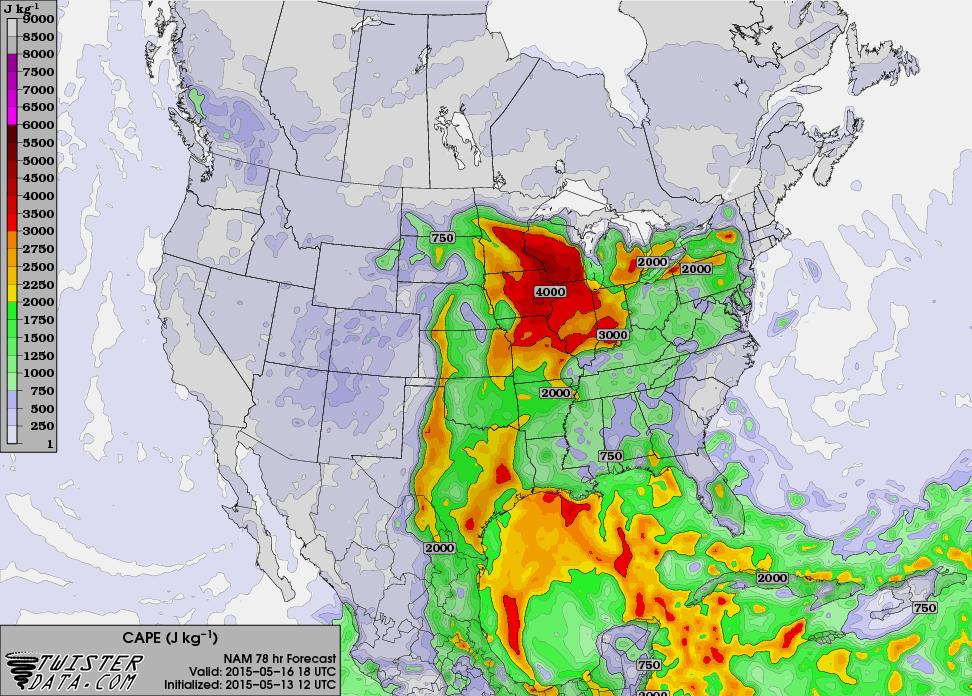
Weekend Severe Threat
...DISCUSSION...
MODELS REMAIN IN REASONABLY GOOD AGREEMENT REGARDING THE TIMING AND
AMPLITUDE OF AN UPPER TROUGH THAT IS FORECAST TO MOVE THROUGH THE CNTRL
PLAINS SATURDAY AND UPPER MS VALLEY AND GREAT LAKES REGION SUNDAY
SATURDAY: A
MOIST WARM SECTOR WILL RESIDE EAST OF A PACIFIC FRONT THAT WILL
ACCOMPANY AN UPPER TROUGH THROUGH THE PLAINS. THE PRIMARY COMPLICATING
FACTOR THIS FORECAST WILL BE THE POTENTIAL FOR EARLY CONVECTION OVER
PORTIONS OF THE WARM SECTOR WITH GREATEST COVERAGE CURRENTLY FORECAST
FROM PARTS OF NRN TX INTO PARTS OF OK AND KS. GIVEN THE MOIST BOUNDARY
LAYER IN PLACE...POTENTIAL WILL EXIST FOR ATMOSPHERE TO BECOME AT LEAST
MODERATELY UNSTABLE DURING THE AFTERNOON. STORMS WILL LIKELY REDEVELOP
ALONG AND AHEAD OF THE FRONT WITHIN DIFLUENT UPPER FLOW REGIME.
DEEP-LAYER WIND PROFILES WILL REMAIN LARGELY MERIDIONAL BUT WILL
STRENGTHEN WITH APPROACH OF THE UPPER TROUGH AND BECOME SUPPORTIVE OF
ORGANIZED SEVERE STORMS.
SUNDAY: SEVERE
THREAT WILL SHIFT INTO THE UPPER MS VALLEY AND GREAT LAKES REGION IN
ASSOCIATION WITH THE PROGRESSIVE UPPER TROUGH AND ATTENDANT STRONG
DEEP-LAYER WIND PROFILES. AS IN DAY 4...EARLY CONVECTION WILL ALSO
COMPLICATE FORECAST AND INCREASE UNCERTAINTY REGARDING WHERE GREATEST
SEVERE POTENTIAL WILL EVOLVE.
Thanks for checking in and have a great rest of your week! Don't forget to follow me on Twitter @TNelsonWX

No comments:
Post a Comment