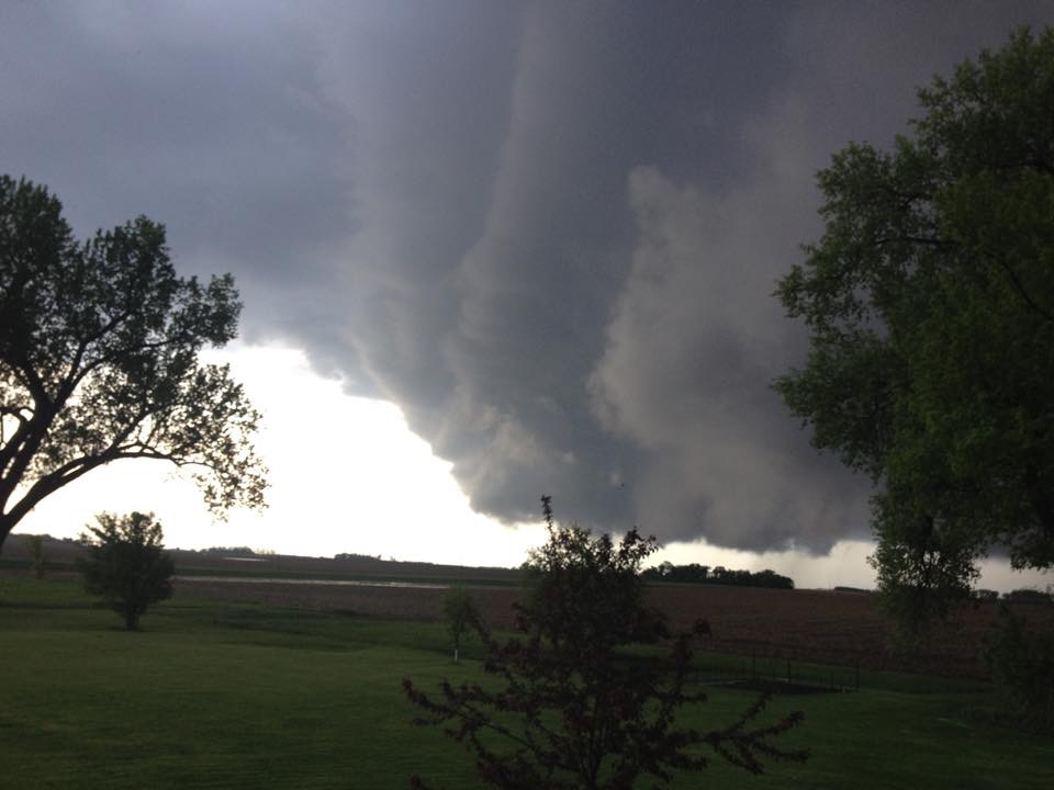
Thanks to Marie Reszel for this picture out of Montevideo. Storms across parts of western Minnesota on Saturday afternoon/evening produced a number of tornadoes. The first tornadoes in the state of Minnesota since September 19th, 2014
Minnesota Tornadoes on Saturday
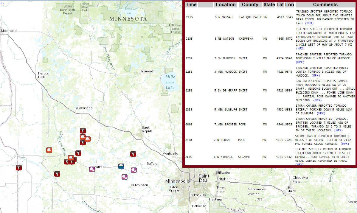
According to the SPC, there were at least 9 PRELIMINARY tornado reports across western Minnesota on Saturday afternoon/early evening. Some damage was reported Kimball, De Graff and Watson.
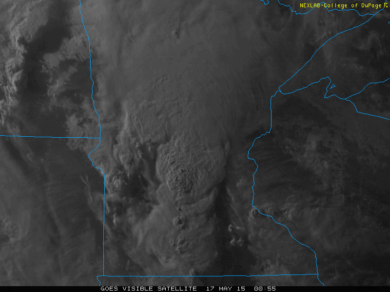
This is what the satellite picture like as the line of strong to severe thunderstorms was moving across western MN. One of the cells at this time was producing a tornado NW of Wilmar.

_________________________________
Sunday Severe?
By Todd Nelson
May can be a fickle month for us in Minnesota. Get this, Minneapolis has seen as much as 3 inches of snow back in 1946 to a 106 degree high back on May 31, 1934. We've also endured several severe weather outbreaks, including tornadoes. The most memorable of which may be the May 6th, 1965 tornado outbreak when 6 tornadoes touched down across the state, 4 of which were rated F4s.
A storm system swirling through the Upper Midwest this weekend has kept weather conditions a little on the unsettled side. Mild and somewhat muggy weather will continue with chances of showers and storms today. The Storm Prediction Center has highlighted parts of Minnesota and Wisconsin as potential risk areas for strong to severe thunderstorm development later today. Keep up to date with weather information as storms rumble through.
We get a bit of a reality check tomorrow on the backside of the storm system as temperatures plummet into the 40s and 50s across the state. A cold wind and a few wind whipped snowflakes across northern Minnesota will make it feel more like early Spring tomorrow. Here's to hoping the erratic May weather levels out by Memorial Weekend. Cheers!
___________________________
SATURDAY NIGHT: Scattered showers and storms. Some possibly strong with heavy rain. Low: 65. Winds: SSE 10-20.
SUNDAY: Still mild and breezy. Scattered showers and storms develop, some strong to severe by PM. High: 78. Winds: SE 15-30
SUNDAY NIGHT: Thunderstorms ending with a few lingering showers overnight. Low: 53. Winds: S 10-20.
MONDAY: Breezy and much cooler. Lingering clouds and light showers with light snow up north early. High: 54. Winds: WSW 15-25
TUESDAY: Chilly breeze. More PM sun. Wake-up: 39. High: 56.
WEDNESDAY: Still cool for May. Wake-up: 42. High: 64.
THURSDAY: Bright sun. 70s return. Wake-up: 47. High: 70.
FRIDAY: Late day shower possible in southern MN. Wake-up: 51. High: 71.
SATURDAY: Unsettled. Spotty PM thundershower. Wake-up: 53. High: 70.
__________________________
This Day in Weather History
May 17th
May 17th
1915: Old Man Winters last hurrah with 5 inches of snow along Lake Superior.
__________________________
__________________________
Average High/Low for Minneapolis
May 17th
May 17th
Average High: 70F (Record: 93F set in 1987)
Average Low: 49F (Record: 31F set in 1915)
__________________________
Average Low: 49F (Record: 31F set in 1915)
__________________________
Sunrise/Sunset Times for Minneapolis
May 17th
May 17th
Sunrise: 5:42am
Sunset: 8:37pm
_________________________
Sunset: 8:37pm
_________________________
Moon Phase for May 17th at Midnight
0.1 Days Since New Moon
0.1 Days Since New Moon

___________________________
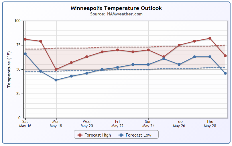
Minneapolis Temperature Trend
Warm weather conditions continue through the weekend with highs in the 70s across much of the state Sunday. Note the significant cool down by Monday as highs crash into the 50s. We make some gradual progress through the week, but it'll be a little slow to warm. Looking ahead to Memorial Weekend, we'll be a little closer to average, but perhaps still a little cooler than we should be in May.
_______________________________
Sunday Weather Outlook
Sunday will be another mild and somewhat muggy day with highs across much of the state warming into the 70s with dewpoints lingering into the upper 50s and low/mid 60s.
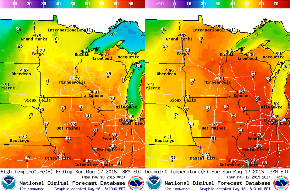
Sunday Weather Outlook
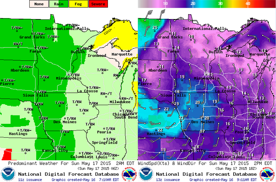
Unsettled weather continues on Sunday with spotty showers and storms, some of which could be strong to severe. Winds will still be breezy out of the south with winds around 10-20mph.
Rainfall Potential
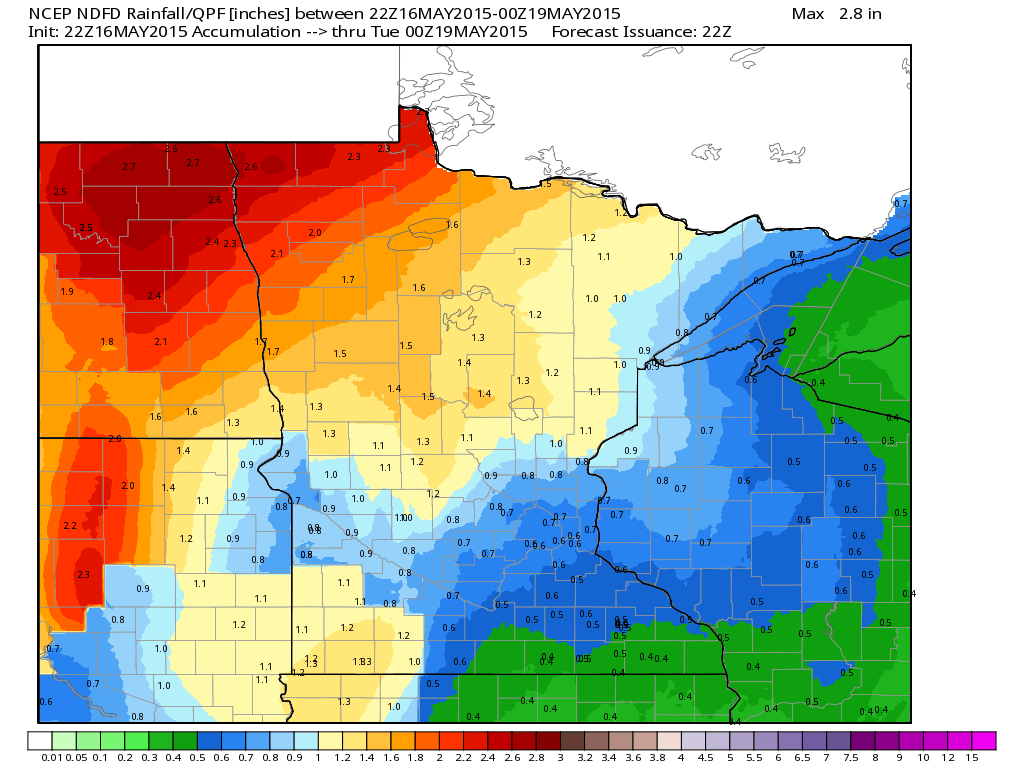
The rainfall forecast from PM Saturday to PM Monday looks quite impressive across northwestern MN with as much as 2" to nearly 2.5", while areas across southeastern Minnesota aren't expected to get as much. The Twin Cities is expected to get around 0.5" or so through early next week.
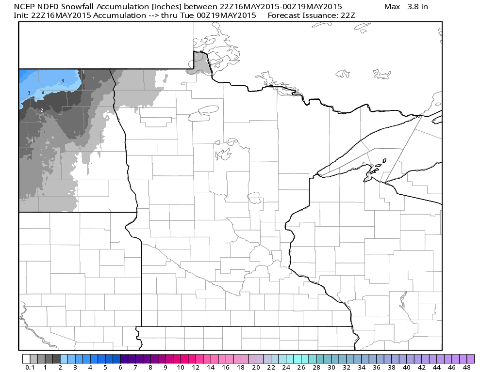
Snowfall Potential?
I hate to say it, but a few locations across far northern MN could be talking snowfall into early this week. While it doesn't look like much, scattered snow showers could be a rude awakening for folks there. Keep in mind that the best chance of any accumulations would be in North Dakota.
_________________________________
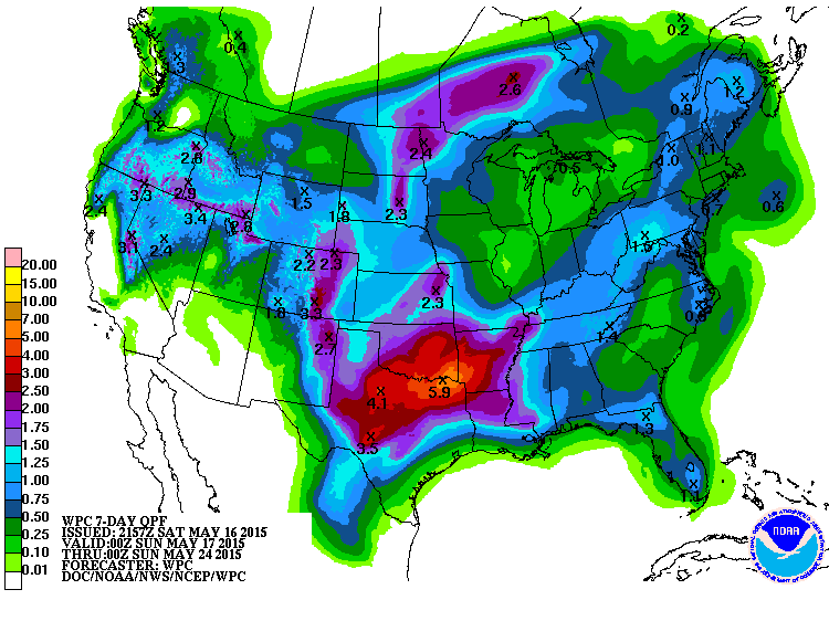
7 Day Precipitation Outlook
According to NOAA's HPC, there could be an additional 2" to nearly 5" of rain across parts of the Central U.S. through next Saturday. It's interesting to note that some of the heaviest precipitation (near 6") could fall near the Arklatex region where radar estimates of rainfall in those areas suggests nearly 6" to 12" has already fallen over the last 7 to 10 days.
_________________________________
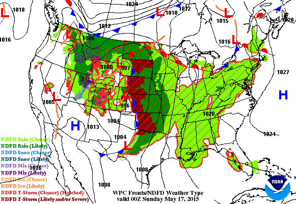
National Weather Outlook
The storm system responsible for all the thunderstorm activity in the central part of the country on Saturday will still play a role in the severe thunderstorm threat across the middle part of the country again Sunday. Interestingly, temperatures on the northwest side of the storm system could be cold enough for a little snow across parts of the Dakotas and northern Minnesota.
___________________________
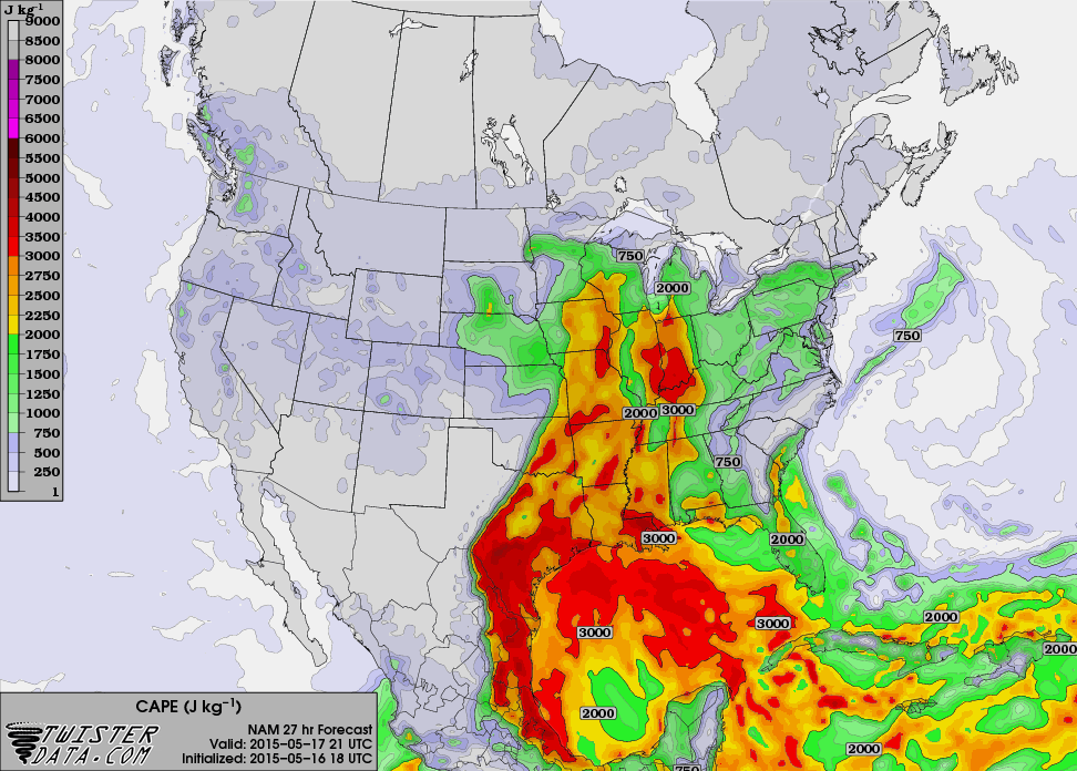
Increasing Instability: CAPE 4pm Sunday
CAPE (Convective Available Potential Energy) is a weather term used to describe how much potential energy is available for thunderstorm development. Note that by Sunday afternoon, there is a plume of higher CAPE values that look to be across parts of central Minnesota and Wisconsin. This could be enough energy for some strong to severe storms if everything comes together right. Stay up to date with latest forecasts and weather
conditions on Sunday.
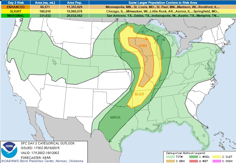
Severe Threat Sunday
...SUMMARY... SEVERE THUNDERSTORMS ARE EXPECTED ACROSS PARTS OF THE MID AND UPPER MISSISSIPPI VALLEY SUNDAY AFTERNOON AND EVENING. THESE WILL BE ACCOMPANIED BY THE RISK FOR LARGE HAIL AND LOCALLY DAMAGING WIND GUSTS. TORNADOES ARE ALSO POSSIBLE...ONE OR TWO OF WHICH MAY BE STRONG. ...SYNOPSIS... BLOCKING WILL REMAIN PROMINENT NEAR THE NORTH AMERICAN PACIFIC COAST THROUGH THIS FORECAST PERIOD. WITHIN THE SOUTHERN BRANCH OF THE SPLIT MID-LATITUDE WESTERLIES...A SERIES OF SIGNIFICANT CLOSED LOWS/SHORT WAVE TROUGHS APPEAR LIKELY TO REMAIN PROGRESSIVE...WITHIN BROADER SCALE TROUGHING ACROSS THE EASTERN PACIFIC THROUGH THE U.S. PLAINS/MISSISSIPPI VALLEY REGION. THIS INCLUDES ONE EMERGING FROM THE INTERMOUNTAIN REGION TODAY...WHICH IS FORECAST TO CONTINUE INTO THE MID/UPPER MISSISSIPPI VALLEY REGION BY LATE SUNDAY NIGHT...AS ANOTHER DIGS ACROSS THE EASTERN PACIFIC...TOWARD THE CALIFORNIA COAST. THE EAST NORTHEASTWARD REDEVELOPMENT OF THE LEAD CLOSED LOW...FROM THE NORTH CENTRAL HIGH PLAINS INTO THE MINNESOTA/ONTARIO BORDER AREA...MAY OCCUR LARGELY IN RESPONSE TO THE PIVOTING OF A STRONG PERTURBATION AROUND ITS EASTERN PERIPHERY...FROM THE CENTRAL PLAINS THROUGH THE UPPER MIDWEST. THIS LATTER FEATURE IS FORECAST TO BE ACCOMPANIED BY A CYCLONICALLY CURVED...50-70 KT SOUTHWESTERLY 500 MB JET. MODELS CONTINUE TO SUGGEST THAT THERE WILL BE WEAKENING OF THIS JET...THE ASSOCIATED SURFACE CYCLONE AND LOWER TROPOSPHERIC WIND FIELDS...BUT THIS MAY BE SLOW TO OCCUR...AND VERTICAL SHEAR SHOULD REMAIN MORE THAN SUFFICIENT TO SUPPORT AN ORGANIZED SEVERE WEATHER THREAT GIVEN SUFFICIENT DESTABILIZATION. MODELS SUGGEST THAT LOWEST PRESSURES ASSOCIATED WITH THE SURFACE CYCLONE DEVELOPING EAST NORTHEAST OF THE DAKOTAS EARLY IN THE PERIOD WILL REMAIN BELOW 1000 MB THROUGH MUCH OF THE PERIOD. SOME SLIGHT DEEPENING APPEARS POSSIBLE AS IT INTERACTS WITH A FRONTAL ZONE WHILE MIGRATING ACROSS MINNESOTA...BEFORE WEAKENING SUNDAY NIGHT AS IT APPROACHES THE UPPER GREAT LAKES REGION. CONTINUED MOISTENING PROBABLY WILL OCCUR ON SOUTHERLY LOW-LEVEL FLOW...AHEAD OF A PRE-FRONTAL WIND SHIFT/DRYLINE STRUCTURE EXPECTED TO ADVANCE EASTWARD ACROSS THE UPPER MISSISSIPPI VALLEY BY EARLY SUNDAY EVENING. THIS BOUNDARY IS EXPECTED TO BECOME THE FOCUS FOR MODERATE BOUNDARY LAYER DESTABILIZATION AND THE STRONGEST THUNDERSTORM ACTIVITY...AS FAR SOUTH AS THE MIDDLE MISSISSIPPI VALLEY SUNDAY AFTERNOON AND EVENING. ACROSS THE OZARK PLATEAU INTO THE SOUTHERN PLAINS...THE SEVERE WEATHER POTENTIAL BECOMES MORE UNCLEAR...DUE TO TRENDS TOWARD WEAKENING DEEP LAYER FORCING FOR ASCENT AND WIND FIELDS...AND THE LIKELIHOOD THAT THE DRYLINE WILL BEGIN RETREATING TOWARD THE SOUTHERN HIGH PLAINS. ...SRN PLAINS THRU MID/UPPER MISSISSIPPI VALLEY... SCATTERED CONVECTIVE DEVELOPMENT MAY BE ONGOING EARLY IN THE PERIOD JUST AHEAD OF THE ENTIRE LENGTH OF THE PRE-FRONTAL WIND SHIFT/DRYLINE. THE IMPACT OF THIS ON SUBSEQUENT BOUNDARY LAYER DESTABILIZATION AND CONVECTIVE POTENTIAL REMAINS UNCLEAR...AND CONTRIBUTES TO FORECAST UNCERTAINTY AND SOMEWHAT TEMPERED SEVERE WEATHER PROBABILITIES FOR THIS FORECAST PERIOD. BARRING COMPLICATIONS FROM ANTECEDENT CONVECTION...MID-LEVEL INHIBITION SHOULD BE RELATIVELY WEAK AS FAR SOUTH AS CENTRAL TEXAS...DUE TO THE LACK OF WARMER ELEVATED MIXED LAYER AIR. BOUNDARY LAYER MOISTURE IS EXPECTED TO BE CHARACTERIZED MID 60S TO NEAR 70F SURFACE DEW POINTS WITHIN A CORRIDOR WRAPPING INTO THE SURFACE LOW CENTER OVER MINNESOTA...PROBABLY CONTRIBUTING TO CAPE ON THE ORDER OF 1000-2000 J/KG...WHERE SURFACE HEATING OCCURS. CURRENTLY...IT SEEMS MOST PROBABLE THAT INSOLATION BENEATH AN EVOLVING SLOT OF MID-LEVEL DRYING/SUBSIDENCE WILL CONTRIBUTE TO A CORRIDOR OF ENHANCED SEVERE WEATHER POTENTIAL BY LATE SUNDAY AFTERNOON...IF NOT EARLIER. AS FORCING FOR ASCENT ASSOCIATED WITH THE PIVOTING MID-LEVEL PERTURBATION OVERSPREADS THE SURFACE WIND SHIFT/DRYLINE...STORM INITIATION SHOULD ENSUE...PERHAPS FIRST ACROSS EAST CENTRAL AND SOUTHEAST MINNESOTA INTO WESTERN WISCONSIN...BEFORE ADDITIONAL DEVELOPMENT OCCURS SOUTHWARD ACROSS NORTHWESTERN ILLINOIS INTO EAST CENTRAL MISSOURI. THIS SEEMS LIKELY TO INCLUDE DISCRETE SUPERCELLS...CAPABLE OF PRODUCING LARGE HAIL...LOCALLY DAMAGING WIND GUSTS...AND A FEW TORNADOES. ONE OR TWO STRONG TORNADOES IS POSSIBLE...PARTICULARLY CLOSER TO THE SURFACE LOW CENTER ACROSS EAST CENTRAL/SOUTHEAST MINNESOTA INTO WESTERN/CENTRAL WISCONSIN.
______________________________
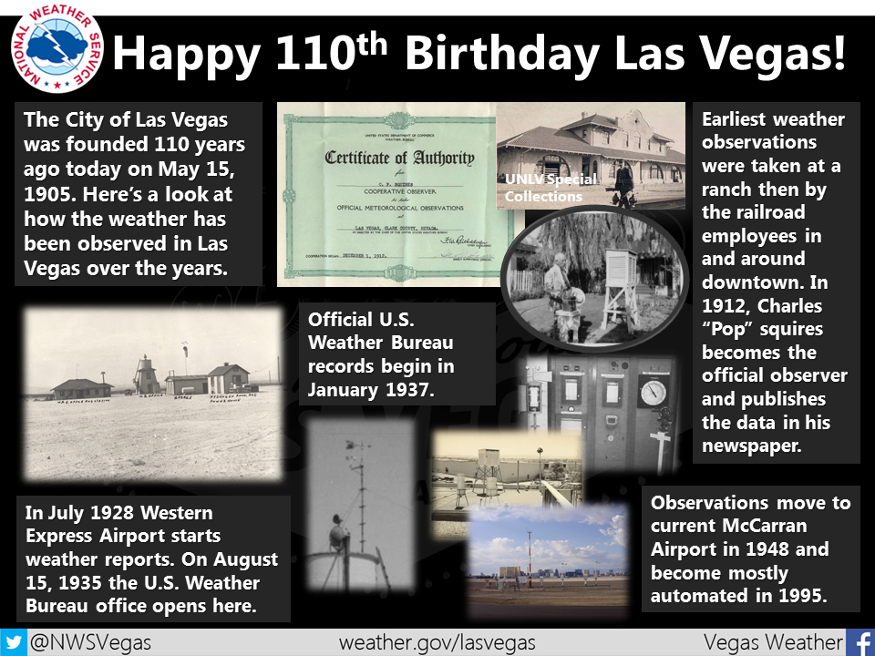
Happy 110th Birthday Las Vegas
In honor of Las Vegas' birthday on May 15th, the National Weather Service out of Las Vegas put together on how the weather has been observed over the years.
________________________________
Weird and Wacky News...
Take a look at this story out of Fairbanks, AK. Sounds like the start of a bad joke!
A beaver walks into an Alaska hardware store ... FAIRBANKS—Sometimes driftwood just isn't enough, one beaver decided when it took an impromptu trip to Lowe's early Friday morning. The beaver wandered into the parking lot of the Lowe's construction and home improvement store on the Johansen Expressway at about 7 a.m., triggering the automatic doors and strolling inside. Once inside the store, the beaver made its way to the plumbing department, where store employees attempted to provide assistance to the wild animal."
(Photo courtesy: Angelesa Ward via Newsminer.com)

______________________________________
Thanks for checking in and have a great rest of your weekend and week ahead! Don't forget to follow me on Twitter @TNelsonWX

I actually wrote a 90-page book on tornado safety, "The No-Nonsense Guide to Tornado Safety" with more helpful information than what can be listed here. It's on Amazon, Lulu books, and Barnes & Nobles (online. Also available in various ebooks formats)
ReplyDelete