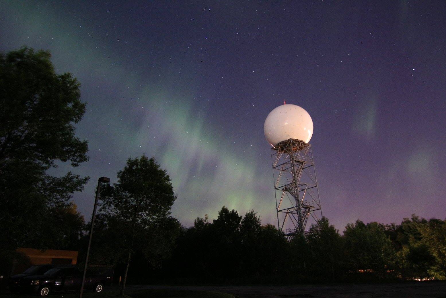
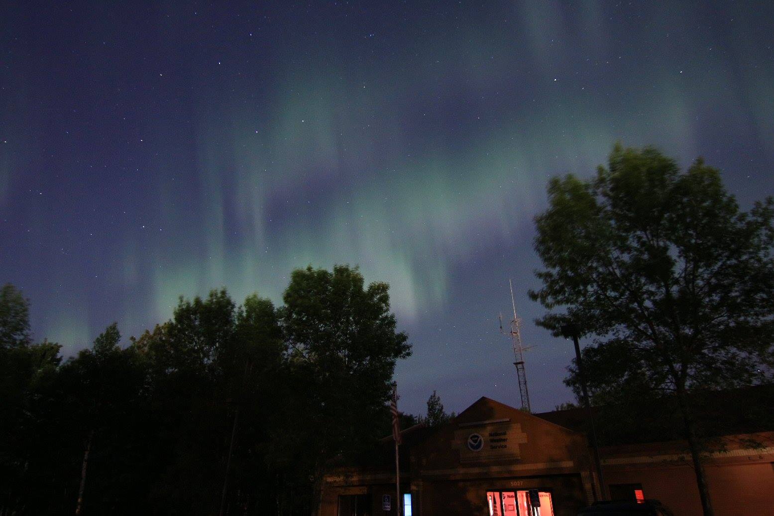
Northern lights were spotted across the high latitudes Monday night/early Tuesday morning. Thanks to the National Weather Service out of Duluth, MN for the pictures below who got in on the excitement as well!
"A strong geomagnetic storm was progress in the wake of a coronal mass ejection that impacted Earth's magnetic field Monday afternoon. The northern lights were clearly visible across all of the Northland where skies have cleared. The pictures below were taken at the Duluth NWS office between 1130 PM and midnight."
See more from the NWS Duluth HERE:
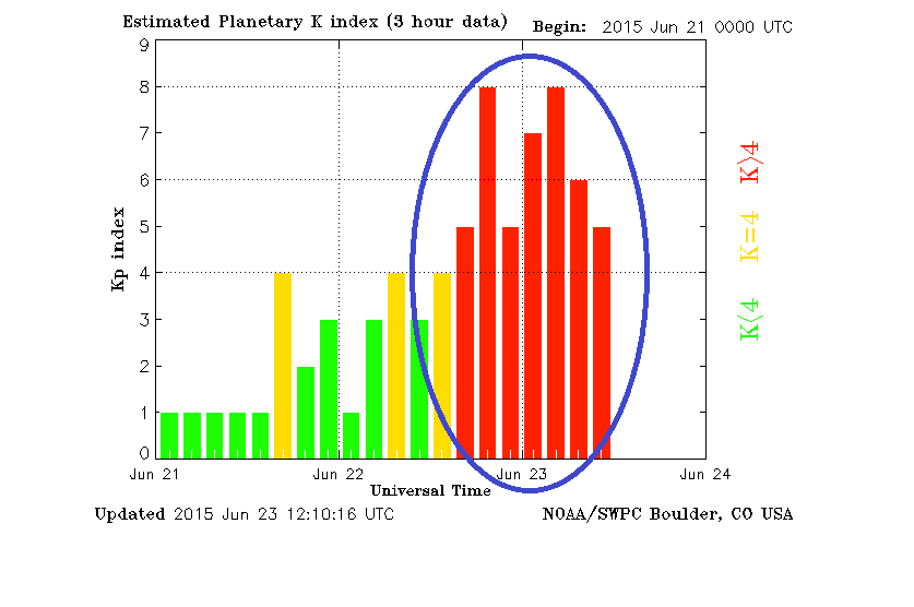
Planetary K-Index
YIKES!! Take a look at the Planetary K-Index from last night! This typical means we're in for a good show IF weather conditions cooperate. Monday night/Tuesday morning was almost ideal viewing despite having a shorter dark period due to extended daylight hours being so close to the summer solstice.
Soft Serve News is a great Northern Lights bookmark to check whether or not they may be visible or not:
Getting Comfortable
By Todd Nelson
My late father used to always tell me "Todd, never get too comfortable. Always be adapting and changing." I guess that's true for many aspects of life, but what about Minnesota weather? I guess that's true too, yes?
It's hard to complain about our June weather so far. Temperatures are running only a little more than 1 degree above average, while precipitation is running about 1 inch above average, which has helped squash the drought that was in place several weeks ago. I am also pleased to report that we have not had a tornado in the state of Minnesota yet this June in a month that averages 18, the most of any other month of the year! I am trying not to take anything for granted at this point, knowing the weather will likely change in the near future.
Another round of severe storms will develop later today across Iowa with damaging winds a possibility through the overnight hours. For us, the next several afternoons look to feature just a few pop up showers and storms as we stay mainly north of the severe storm track. While we stay quiet, a heat wave looks to be brewing in the West. High temps this weekend could reach the 100s in Washington state. WHEW!
___________________________
TUESDAY NIGHT: Partly cloudy, nothing rough. Low: 62. Winds: WSW 5-10
WEDNESDAY: More clouds, spotty PM thunder possible. High: 83. Winds: S 5-10
WEDNESDAY NIGHT: Slight chance of a passing thundershower. Low: 64.
THURSDAY: Spotty afternoon rumbles. High: 80.
FRIDAY: Isolated PM T-shower possible, mainly southern MN. Wake-up: 62. High: 78
SATURDAY: Mostly dry. Puffy afternoon clouds. Wake-up: 60. High: 81
SUNDAY: Scattered PM storms. Wake-up: 62. High: 80.
MONDAY: Sun returns, still mild and a little more humid. Wake-up: 64. High: 82.
TUESDAY: Warmer, slight chance of thunder. Wake-up: 64. High: 87.
___________________________
This Day in Weather History
June 24th
2002: Heavy rains fell on already saturated ground on 24. 5.50 inches fell at Delano. Half of a mobile home park at Howard Lake was evacuated due to rising water.
1972: Frost across eastern Minnesota. Duluth had a low of 35 and Tower bottomed out at 32.
____________________________
Average High/Low for Minneapolis
June 24th
Average High: 82F (Record: 101F set in 1988)
Average Low: 62F (Record: 44F set in 1972)
_____________________________
Sunrise/Sunset Times for Minneapolis
June 24th
Sunrise: 5:27am
Sunset: 9:03pm
_____________________________
Moon Phase for June 24th at Midnight
0.8 Days Since First Quarter
_______________________________
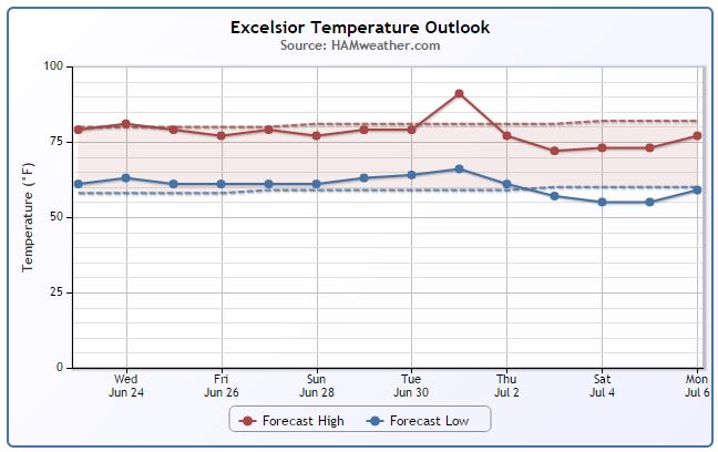
Minneapolis Temperature Trend
It's been a pretty easy June thus far with our average temperature in Minneapolis running only about 1F above average. Looking ahead through much of the rest of the month, temperatures should continue to stay right around where we should be at this time of year (near 80F).
________________________________
Wednesday Weather Outlook
Wednesday looks like another fairly spectacular day with highs running close to average across much of the state. Winds on Wednesday look to stay mostly light as well.
Wednesday Weather Outlook Continued
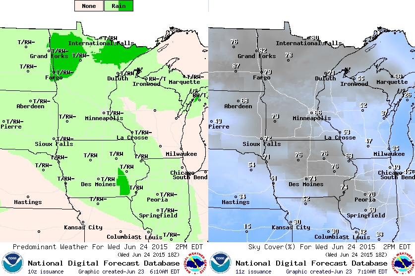
Late day showers and storms look to pop up on Wednesday with a few pockets of heavy rain possible, mainly across northern Minnesota. You'll also notice a few more clouds scattered around the area on Wednesday afternoon/evening as well.
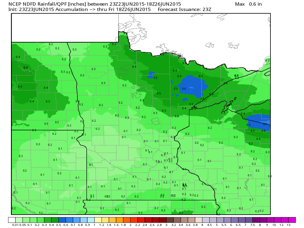
Rainfall Potential
Rainfall potential across the state looks fairly minimal through midday Friday with the exception of far northeastern Minnesota.
_____________________________________
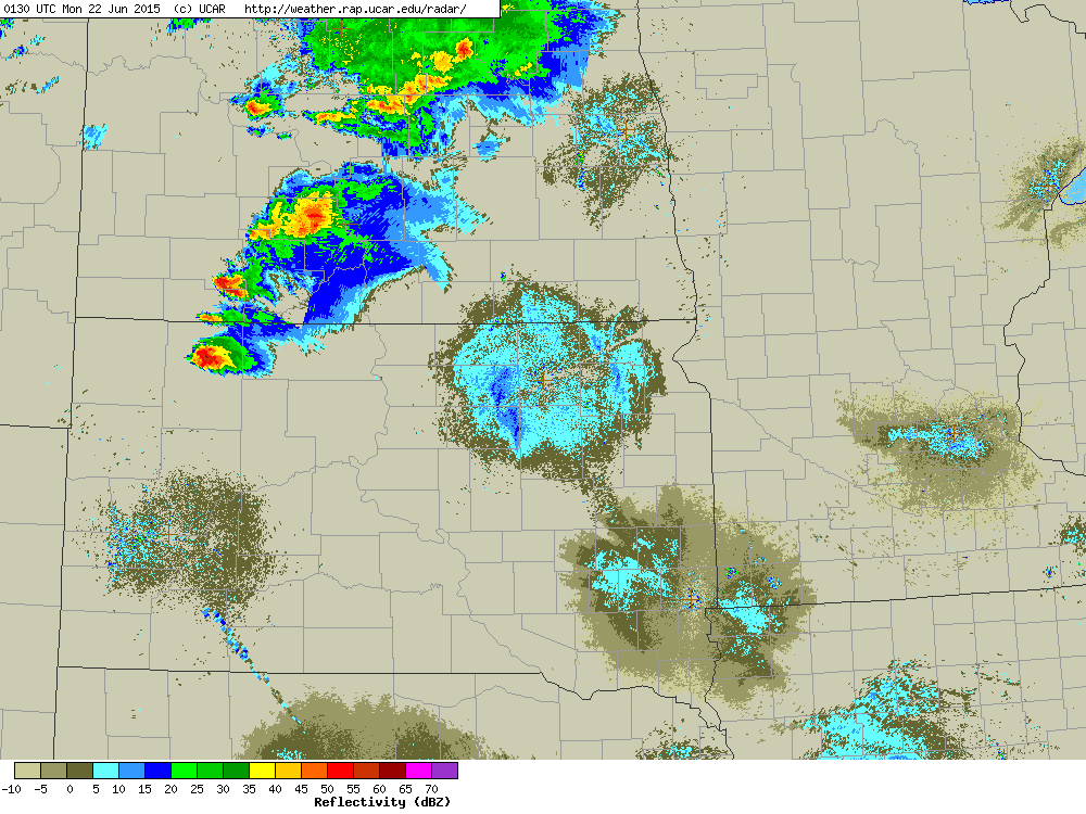
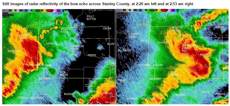
122mph Thunderstorm Wind Gust??
Early Monday morning (June 21st), strong thunderstorms developed across South Dakota and produced a 122mph thunderstorm wind gust in the central part of the state. Here's an excerpt from the NWS out of Aberdeen, SD:
"By 12:30 am CDT, supcercells developed across the northern Black Hills. These storms rapidly moved east at around 60 mph and morphed into a severe bow echo. By 2:20 am, the storm entered western Stanley County and at 2:32 am it produced a wind gust of 122 mph near Hayes, as measured by a home weather station. One person was injured here as a camper was rolled. An office building was also moved and grain bins were destroyed in the Hayes area. To put this kind of wind speed in perspective, an EF2 tornado has wind speeds of 111-135 mph, and a category 3 hurricane has wind speeds of 111-129 mph. This very dangerous storm continued blasting east and reached Pierre and Fort Pierre around the 3:00 am timeframe. Major widespread damage occured in both cities as winds up to 81 mph were measured at the Pierre airport at 3:09 am. Reports of damage include countless large trees down, a flipped moble home and semi trucks, at least one grain silo and several buildings damaged. Winds as high as 70+ mph continued for some time after the passage of the storm in Pierre, which exacerbated the situation. This storm would then move on to affect Lyman, Hyde, Hand, and Buffalo Counties (the same areas that had been devastated by a similar system 2 days prior) before moving into southeastern SD, resulting in severe damage in the Sioux Falls area. The storm continued eastward into the early morning and afternoon on the 22nd to affect southern Minnesota, northern Iowa, and Ilinois."
See more on the event from the NWS Aberdeen HERE:
_____________________________________
National Weather Outlook
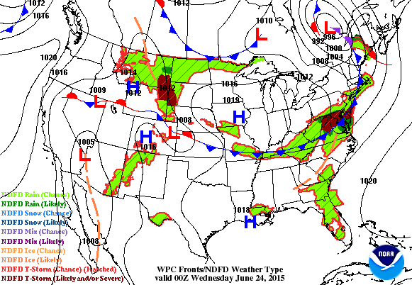
Another impulse of energy works through the Midwest on Wednesday and Thursday with the heaviest rainfall looking to stay mainly south of Minnesota. Keep in mind that some of the storms associated with this next system could be strong to severe.
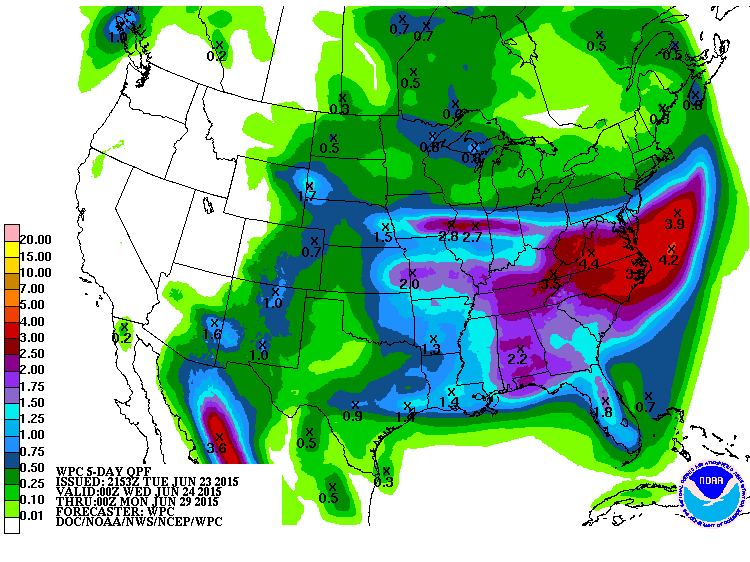
5 Day Rainfall Potential
According to NOAA's HPC, the 5 day rainfall forecast shows heavy rainfall across parts of the Central and Eastern U.S. through PM Sunday. Some of the heaviest through the time period looks to fall across parts of the Mid-Atlantic States with as much as 2" to nearly 4" possible.
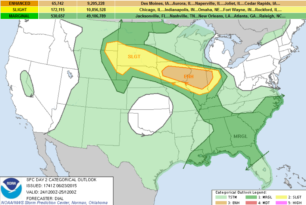
Severe Threat Wednesday
...SUMMARY... A SEVERE THREAT IS EXPECTED FROM PARTS OF THE NORTHERN PLAINS EAST SOUTHEASTWARD INTO THE MIDWEST ON WEDNESDAY. LARGE HAIL AND DAMAGING WIND GUSTS ALONG WITH A THREAT FOR A FEW TORNADOES WILL BE POSSIBLE DURING THE AFTERNOON AND EVENING. POTENTIAL FOR A STRONG TORNADO AND HAILSTONES OF GREATER THAN 2 INCHES COULD ALSO DEVELOP ACROSS PARTS OF IOWA INTO NORTHERN ILLINOIS. THREAT WILL ALSO EXIST FOR A SWATH OF WIDESPREAD DAMAGING WIND FROM SOUTHERN IOWA THROUGH NORTHERN ILLINOIS AND POSSIBLY INTO NORTHERN INDIANA. ...SYNOPSIS... TYPICAL SUMMER PATTERN WITH BELT OF FASTER QUASI-ZONAL WLYS OVER THE NRN THIRD OF THE COUNTRY WILL PERSIST WEDNESDAY. A SERIES OF LOW AMPLITUDE IMPULSES EMBEDDED WITHIN THIS FLOW REGIME WILL MOVE THROUGH THE NRN PLAINS INTO THE UPPER MIDWEST. HIGH PRESSURE WILL PREVAIL OVER THE SRN HALF OF THE U.S.. AT THE SFC QUASI-STATIONARY FRONT WILL LIKELY EXTEND FROM NC THEN WWD AND NWWD THROUGH THE TN VALLEY INTO SWRN IA THEN WWD TO A WEAK SFC LOW IN NWRN KS OR SWRN NEB. WRN PORTION OF THIS BOUNDARY MAY MOVE SLOWLY NWD DURING THE DAY. ...MID MS VALLEY REGION... AN MCS WILL LIKELY BE ONGOING EARLY WEDNESDAY FROM PORTIONS OF NEB INTO IA WHERE ASCENT WILL BE AUGMENTED WHERE THE LLJ INTERSECTS THE BAROCLINIC ZONE. TENDENCY WILL BE FOR LLJ TO VEER AND DEVELOP EWD DURING THE DAY IN ASSOCIATION WITH A PROGRESSIVE...LOW-AMPLITUDE SHORTWAVE TROUGH EMBEDDED WITHIN BELT OF FASTER WLYS. ATMOSPHERE IS EXPECTED TO BECOME MODERATELY TO STRONGLY UNSTABLE IN VICINITY OF THE FRONT AND SOUTH OF ONGOING MCS WHERE STEEP MID-LEVEL LAPSE RATES WILL HAVE OVERSPREAD AXIS OF RICHER LOW-LEVEL MOISTURE. WHILE EVOLUTION OF MORNING STORMS REMAINS SOMEWHAT UNCERTAIN...POTENTIAL WILL EXIST FOR SOME OF THIS ACTIVITY TO BECOME FORWARD PROPAGATING OR NEW STORMS MAY DEVELOP LATER IN THE DAY AND CONTINUE ESEWD THROUGH IA AND NRN IL AS THE DOWNSTREAM ATMOSPHERE DESTABILIZES. STORMS WILL BE EMBEDDED WITHIN 40+ KT EFFECTIVE BULK SHEAR SUPPORTING ORGANIZED STRUCTURES INCLUDING SUPERCELLS AND BOWING SEGMENTS. VERY LARGE HAIL...A FEW TORNADOES AND DAMAGING WIND WILL BE POSSIBLE WITH DAMAGING WIND BECOMING THE DOMINANT THREAT AS STORMS GROW UPSCALE AND CONTINUE THROUGH NRN IL. AN UPGRADE TO MODERATE RISK MIGHT BE NEEDED IN LATER OUTLOOKS ONCE EXTENT OF AND EVOLUTION OF MORNING MCS BECOMES MORE APPARENT. ...CNTRL/NRN PLAINS.... ELY LOW-LEVEL FLOW NORTH OF FRONT/SFC LOW WILL MAINTAIN UPPER 50S DEWPOINTS BENEATH STEEP LAPSE RATES SUPPORTING A CORRIDOR OF MODERATE INSTABILITY. STORMS ARE EXPECTED TO DEVELOP OVER THE HIGHER TERRAIN AND SPREAD EWD INTO THE PLAINS WHERE EFFECTIVE SHEAR WILL BE SUPPORTIVE OF ORGANIZED STORMS INCLUDING SUPERCELLS. LARGE HAIL AND DAMAGING WIND WILL BE THE MAIN THREATS FROM LATE AFTERNOON INTO THE EVENING.
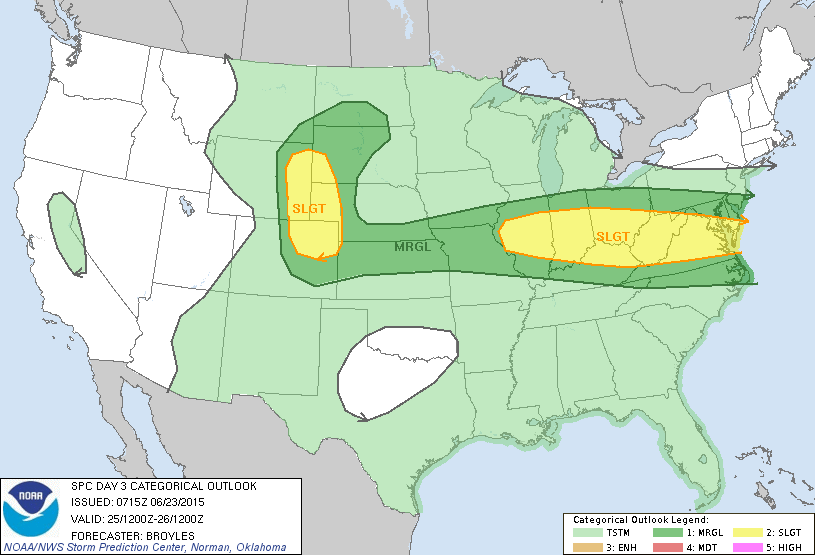
Severe Threat Thursday
...SUMMARY... STRONG TO SEVERE THUNDERSTORMS WITH POTENTIAL FOR DAMAGING WIND GUSTS AND HAIL WILL BE POSSIBLE THURSDAY AFTERNOON ACROSS THE OHIO VALLEY TO THE MID-ATLANTIC. A SEVERE THREAT IS ALSO EXPECTED TO DEVELOP LATE THURSDAY AFTERNOON ACROSS PARTS OF THE CENTRAL AND NORTHERN PLAINS WHERE LARGE HAIL AND ISOLATED DAMAGING WIND GUSTS WILL ALSO BE POSSIBLE. ...OH VALLEY/MID-ATLANTIC... AN UPPER-LEVEL TROUGH IS FORECAST TO MOVE EWD ACROSS THE MID-ATLANTIC ON THURSDAY AS A COLD FRONT ADVANCES SLOWLY SWD ACROSS THE OH VALLEY AND MID-ATLANTIC. SFC DEWPOINTS ALONG AND SOUTH OF THE BOUNDARY SHOULD RANGE FROM THE MID 60S IN THE CNTRL APPALACHIANS TO THE LOWER 70S F IN THE OH VALLEY AND MID-ATLANTIC. AS SFC TEMPS WARM...THE MOIST AIRMASS WILL CONTRIBUTE TO A CORRIDOR OF MODERATE INSTABILITY BY AFTERNOON. AS LOW-LEVEL CONVERGENCE INCREASES ALONG THE BOUNDARY...THUNDERSTORM DEVELOPMENT WILL BECOME POSSIBLE WITH SEVERAL STORM CLUSTERS OR LINE SEGMENTS ORGANIZING DURING THE LATE AFTERNOON. NAM FORECAST SOUNDINGS AT 00Z/FRIDAY FROM NEAR CINCINNATI OH EWD TO NEAR ROANOKE VA SHOW MLCAPE VALUES GENERALLY IN THE 1500 TO 2000 J/KG RANGE WITH STEEP LOW-LEVEL LAPSE RATES AND 40 TO 50 KT OF 0-6 KM SHEAR. THIS MAY BE ENOUGH FOR AN ORGANIZED SEVERE THREAT WITH BOWING LINE SEGMENTS. A SUPERCELL OR TWO COULD ALSO DEVELOP IN AREAS WHERE INSTABILITY BECOMES MAXIMIZED. WIND DAMAGE AND HAIL SHOULD BE THE PRIMARY THREATS WITH THE MORE INTENSE THUNDERSTORMS LATE THURSDAY AFTERNOON. ...CNTRL AND NRN HIGH PLAINS... WEST TO NORTHWEST MID-LEVEL FLOW IS FORECAST ACROSS THE NCNTRL STATES ON THURSDAY AS A SUBTLE SHORTWAVE TROUGH MOVES ESEWD ACROSS THE NRN AND CNTRL HIGH PLAINS. AT THE SFC...UPSLOPE FLOW IS FORECAST ACROSS MUCH OF NE CO...WRN NEB AND ERN WY WHERE SFC DEWPOINTS SHOULD BE MOSTLY IN THE 50S AND LOWER 60S F. THIS SHOULD ENABLE AN AXIS OF MODERATE INSTABILITY TO DEVELOP BY AFTERNOON FROM NE CO NWD ACROSS ERN WY WHERE THUNDERSTORM DEVELOPMENT WILL BE POSSIBLE IN THE HIGHER TERRAIN DURING THE LATE AFTERNOON. AS CELLS INCREASE IN COVERAGE...A COUPLE OF STORM CLUSTERS SHOULD MOVE EWD INTO THE LOWER ELEVATIONS OF THE CNTRL AND NRN HIGH PLAINS. IN ADDITION TO MODERATE INSTABILITY...FORECAST SOUNDINGS AT 00Z/FRIDAY ACROSS ERN WY SHOW 40 TO 45 KT OF DEEP-LAYER SHEAR WITH STEEP LAPSE RATES. THIS SHOULD SUPPORT SUPERCELLS WITH A POTENTIAL FOR LARGE HAIL. WIND DAMAGE WILL ALSO BE POSSIBLE AS DOWNDRAFTS MATURE DURING THE LATE AFTERNOON AND EARLY EVENING.
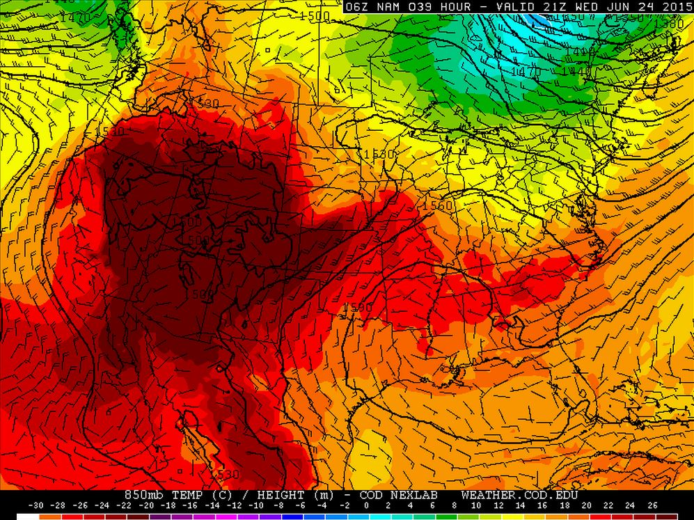
Summer Heat Continues
Record to near record highs have been ongoing across parts of the East Coast and the Southwest over the past several days. Note the big blob of warmer weather developing in Western U.S.! It appears that this heat will continue to build north with highs in the 100s across Washington state by the weekend.
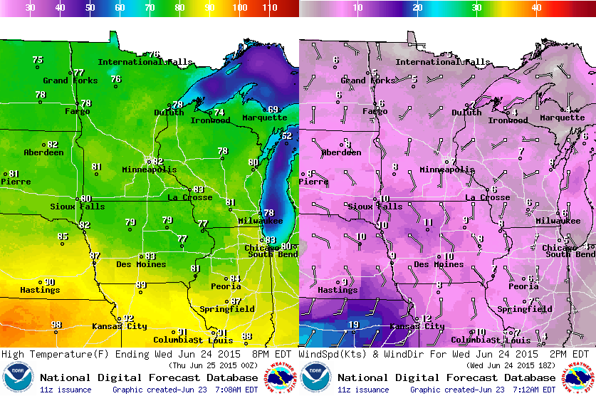
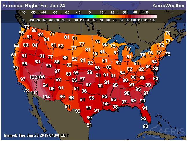
Highs Wednesday
Highs on Wednesday across the southern half of the nation look quite warm. Some locations could be close to records along the East Coast.
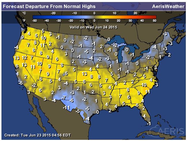
Highs From Average Wednesday
Highs on Wednesday across parts of the Western U.S., Central Plains and the Southeast could be as much as 5 to nearly 15 degrees above average.
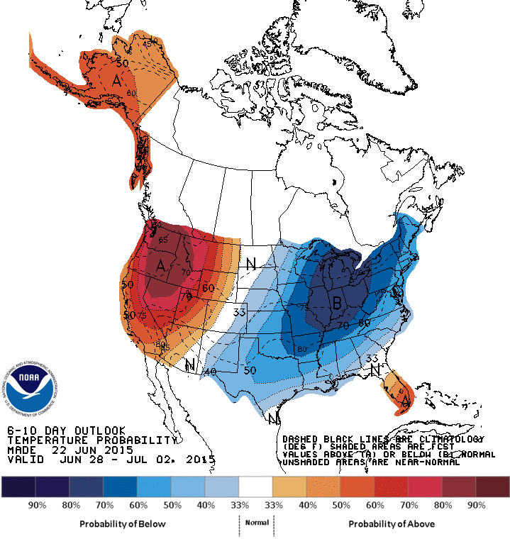
6 to 10 Day Temperature Outlook
Interestingly, the 6 to 10 day temperature outlook shows a blob of cooler than average weather settling in to the eastern half of the country late June/early July, while the western third of the nation looks to be much warmer than average!
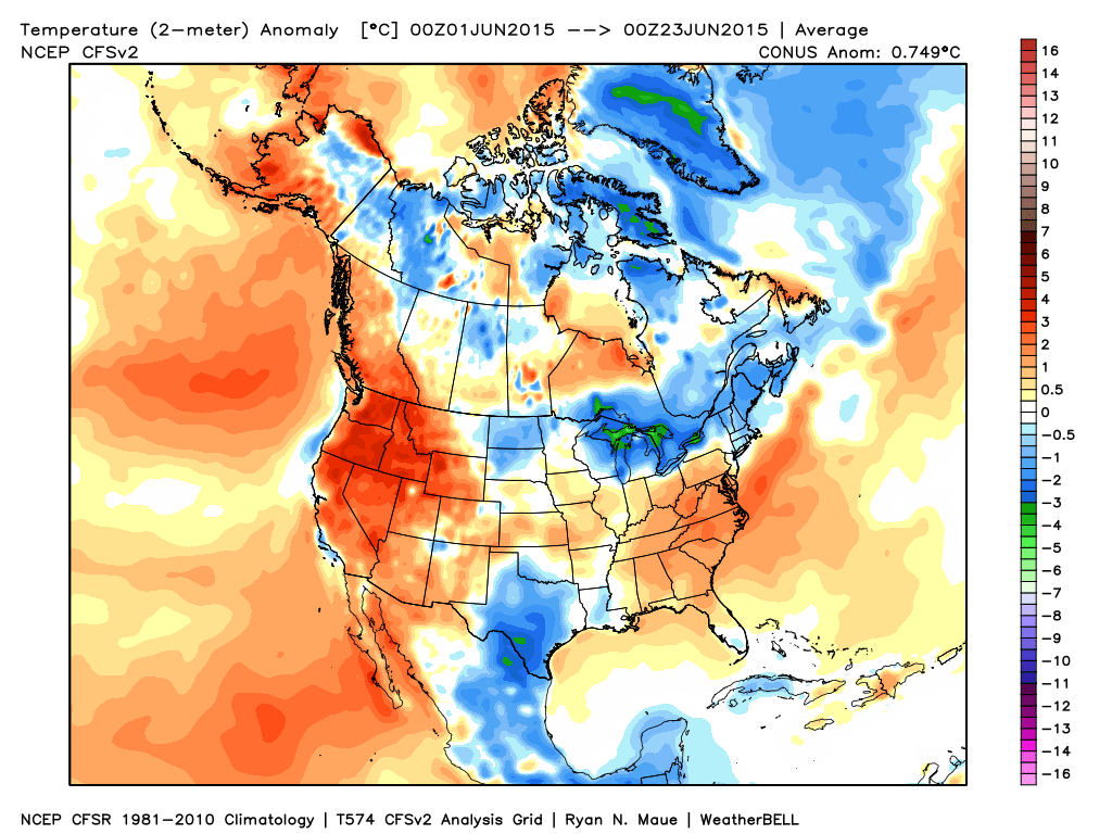
Temperature Anomaly So Far This June
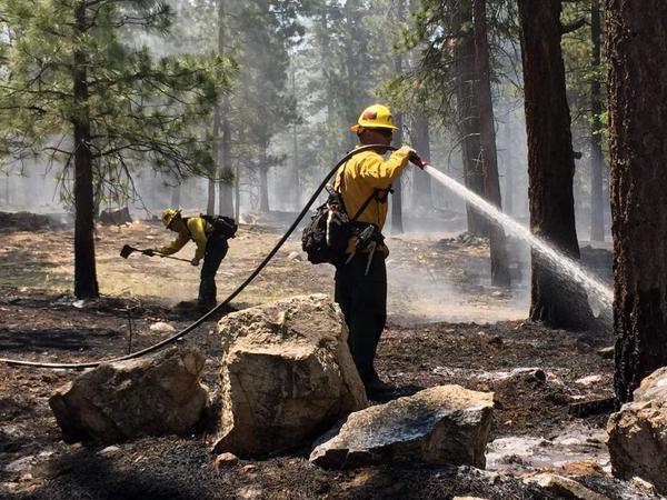
Lake Fire in California
As of Monday, June 22nd the Lake Fire had consumed 17,400 acres in the San Bernardino Mountains just east of Los Angeles, CA. Unfortunately, the fire was only 24% contained and the weather forecast calls for more hot and dry weather.
See more from Inciweb HERE:
(image courtesy: Inciweb)
"CAL FIRE Says Fire Conditions In 2015 Is Worst On Record"
Here's some news that we didn't want to hear. According to CAL FIRE, fire conditions so far this year are worst on record!
Here's an excerpt from CapRadio.org:
"Cal Fire says four years of drought and the timing of the rains this spring have combined to make 2015 the worst fire conditions on record. About a dozen fire chiefs kicked off Wildfire Awareness Week in Pollock Pines on Monday. The backdrop for the meeting -97,717 acres burned in the King Fire last year. Cal Fire says the timing of this year's rains and four years of drought will combine to make fire conditions in 2015 the worst on record."
Thanks for checking in and have a great rest of your week. Don't forget to follow me on Twitter @TNelsonWX

No comments:
Post a Comment