85 F. high in the Twin Cities Thursday.
83 F. average high on July 30
83 F. high on July 30, 2014.
July 31, 1961: Downpour in Albert Lea with 6.7 inches in 24 hours. Source: MPX National Weather Service.
Canadian PaybackMea culpa.
Roughly
7 months out of the year the term "Canadian cold front" is a
pejorative, a negative, cringe-worthy expletive. "Canada exports wheat,
oil, hockey players and cold fronts!" But give credit where credit is
due: much of America is broiling; tens of millions of our brethren
wilting under a heat index above 100F. But a persistent west/northwest
jet stream wind flow aloft has allowed a conga-line of (refreshing,
wondrous!) Canadian cool fronts to burp south of the border, taking the
edge off the heat from St. Paul to Detroit and Boston.
I'm sending
a Hallmark thank you note to Canada for the comfortable, sun-scrubbed
sky outside my window. A/C optional? Highly unusual for late July.
Fasten
your seat belt and prepare to ride out some of the best weather of the
year: 80s into next week, with occasional puffs of Canadian air keeping
the dew point very tolerable - little chance of severe weather or
monsoon rains. A few T-storms may pop up late
Sunday, but most of the upcoming weekend will be dry and pleasantly warm.
Rainfall since
June 1 is running 3.7 inches above average in the Twin Cities. No drought, no storms, no midsummer sweat. What's not to like?
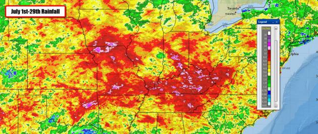
Record Rains in July. Here's an excerpt of AerisWeather meteorologist D.J. Kayser's excellent
blog post on record rains this month across much of the USA east of the Rockies: "...
Heavy
rain once again fell over parts of the central and southeast United
States, leaving some locations with over 10″ of rain during the month. Indianapolis, IN,
saw their wettest MONTH on record this July, with 13.14″ falling
through July 29th. The previous monthly record for the Crossroads of
America was 13.12″ back in July of 1875. It’s also been wet in parts of
Texas (more on that in a moment) with 8.26″ falling in Abilene, TX, making it the wettest July on record..."
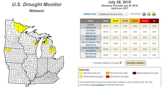
Drought-Free. It's remarkable how quickly the late spring drought has faded east of the Rockies. The latest
U.S. Drought Monitor
shows a few pockets of dry soil, but a total lack of drought from the
Upper Midwest and Great Lakes into the Ohio Valley. One measure of how
good the weather has been over such a huge area: favorable soil moisture
and the prospect of a record corn harvest has depressed prices.
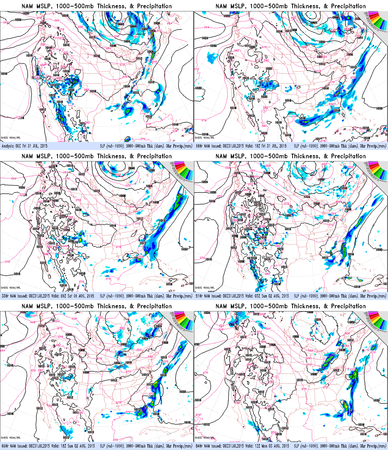
Best Chance of T-storms: Saturday Night.
Model guidance brings a weak trough of low pressure through late
Saturday, capable of a few hours of showers and thunder. By Sunday winds
shift around to the northwest and we dry out with another welcome dip
in humidity. The forecast looks relatively dry as we sail into early
August.
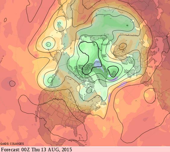
An Extended Heat Wave For Much of America.
Frequent intrusions of cooler, drier Canadian air will continue to take
the edge off the heat from Minnesota across the Great Lakes into New
England, but much of the USA fries under sweltering 90 and even
100-degree heat into mid-August, based on the 14 day GFS outlook at 500
mb.
Summer Swelter: Heat Wave Scorches from Coast to Coast. USA TODAY
takes a look at broiling heat afflicting much of America; here's an
excerpt: "
Yes, it's summer, and it's supposed to be hot, but this is a
bit on the extreme side. As of 2 p.m. ET Wednesday, 110 million
Americans in at least 35 states were sweltering under a temperature of
least 90 degrees, according to WeatherBell meteorologist Ryan Maue.
About 35 million people were enduring a heat index of at least 100
degrees, he said..."
Devastating Floods Might Be More Common Than We Thought, Study Says.
The Los Angeles Times has a summary of recent research; here's an excerpt: "...
But
some of the worst floods in coastal areas are caused by the unfortunate
concurrence of big storm surges with high rainfall – a double-whammy
for flooding, because it can result in the sea spilling over onto land
while rivers and urban drainage systems overflow onto the streets. By
examining these two phenomena together, researchers showed that heavy
precipitation and high seas are occurring in tandem more often in many
coastal cities, especially along the Gulf and Atlantic coasts of the
U.S. The results were published this week in Nature Climate Change...."
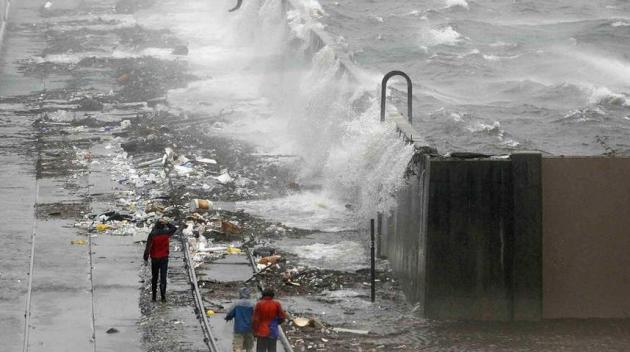
Photo credit above: "
The
chances of heavy rainfall and high storm surges occuring in tandem is
increasing, which puts U.S. cities at greater risk of flooding,
researchers say. Above, water flows over the Industrial Canal floodwall
in New Orleans in 2008." (Eliot Kamenitzd / The Times-Picayune via AP).
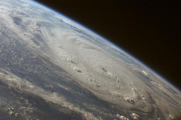
Younger Floridians Discount Hurricane Threat.
The fact that the USA hasn't experienced a Category 3 or stronger
hurricane in a decade is one factor. Older people remember - and tend to
have respect for hurricanes. But if you've never experienced one?
Here's an excerpt from
The Jacksonville Democrat: "
Those
who experience hurricanes rarely lose their awe for the forces of
nature. Many young people, though, have no idea of the kind of
devastation hurricanes can cause. Those are some of the conclusions that
could be drawn from a July Mason-Dixon poll of Florida residents 10
years after the record breaking summer of hurricanes Katrina, Dennis,
Rita and Wilma. “That millennial group — some of the younger ones were
in elementary school the last time there was a hurricane,” said J. Brad
Coker, managing director of the Mason-Dixon Polling & Research Inc..." (File photo: NASA).
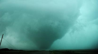
Manitoba Tornado Was An F2: Environment Canada. Here's the intro to a story at
The Winnipeg Sun: "
A
massive tornado that struck western Manitoba this week has been given
an preliminary rating which puts it in the category of large and
violent, but not the worst that nature can serve up. Environment Canada
says the twister that roared through the Virden region near the
Saskatchewan boundary Monday evening was of the high-end EF2 variety.
Such tornadoes can pack wind speeds ranging from 179 kilometres an hour
to 218 kilometres an hour -- capable of lifting cars, ripping out trees
and damaging roofs..."
Photo credit above: "
This twister that tore through southwestern Manitoba on Monday night has been classified as an F2." (GREG JOHNSON/TORNADO HUNTERS PHOTO).
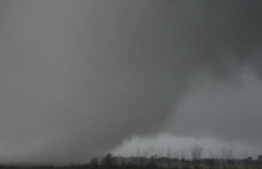
3-Hour Canadian Tornado Likely One Of The World's Longest.
I still have trouble believing that this was ONE TORNADO, rather than a
series of tornadoes spinning up under the same parent supercell. Then
again these days I wouldn't rule anything out. Here's a clip from
USA TODAY:
"he massive tornado that roared across the Canadian province of
Manitoba late Monday was on the ground for nearly 3 hours — likely one
of the longest-lasting on record in Canada and perhaps the world. No
injuries or deaths were reported. The longest tornado recorded is the
infamous Tri-State tornado that lasted for about 3.5 hours, ravaging the
Midwest in March 1925 and leaving hundreds of people dead in its
wake..."
Frame grab credit above: "
A screen grab of Monday's tornado in Manitoba, which was on the ground for nearly 3 hours." (Photo: TVNWeather.com).
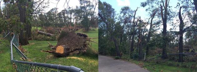
July 12 Storm Damage Clean-up Continues.
Thanks to AerisWeather meteorologist Todd Nelson, vacationing up at
Craguns Resort on Gull Lake with his family. He sent me these photos on
Wednesday, and said "
All I can hear is distant chainsaws...huge piles of lumber everywhere!"
Evidence of Microburst Winds at Maddens Resort.
State Representative Mark Anderson and his wife Barbara took me out on
Gull Lake Sunday to get a first-hand look at the damage in the Brainerd
Lakes area. This is the employee housing at Maddens, missing much of the
roof, evidence of severe wind damage everywhere. This is in line with
Duluth NWS wind estimates of 100 mph in a series of downbursts. Much
like a tornado the damage swaths were fickle and spotty, many areas
spared, but other pockets of extreme damage, trees snapped like
toothpicks. The damage path was linear, no evidence of rotation found in
tornadic winds.
Awe-Inspiring.
This is one of the photos I shared with the GCOLA, the Gull Chain of
Lakes Association Gala event Monday evening up at the Grand View Lodge
(which also suffered tree damage, but nothing like the southern end of
Gull Lake). I snapped this panorama on my trusty iPhone about 4 miles
east of Schaefer's grocery store in Nisswa, just north of Co. 13. It
looked like the fist of God came crashing down, snapping trees in a
swath maybe half a mile wide, again, consistent with
severe downburst or microburst winds.
Poleward Shift in Derecho/Downburst Winds with Warming Climate?
In response to a reader's question about frequency of these kinds of
damaging, freakish wind storms I asked state climatologist Greg Spoden
about trends he's witnessed. Are we imagining an increase, or does the
data confirm an increase in these derecho/downburst wind events? Here is
what Greg wrote:
"
The National Weather Service Storm Prediction Center offers an excellent overview of derechos and derecho climatology here.
In their section on derechos and climate change they reinforce Paul's
comment about a poleward shift in the corridors of maximum derecho
frequency." - Greg Spoden, State Climatologist
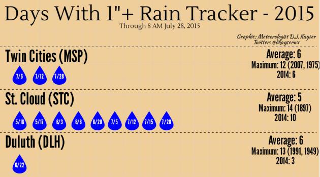
An Unusually Soggy July. AerisWeather meteorologist D.J. Kayser has an
interesting blog post focused on the number of days with 1" or more of rain, compared to long-term averages; here's an excerpt: "...
As
you may have noticed above, both St. Cloud and the Twin Cities saw rain
totals of over an inch this morning. So, we break out the 1″+ rain
tracker once again today! The Twin Cities is now up to three days this
year, all occurring during the month of July, with at least one inch of
rain – half way toward the yearly average of six. St. Cloud has now seen
nine days this year with at least one inch of rain, one away from
matching the number seen during 2014. This also marks the fourth one
inch or greater rain this month in St. Cloud..."
How To Stay Safe When The Big One Comes.
Here's a follow-up to the recent (terrifying) piece in the New Yorker
focused on the probability of a monster 9.0+ earthquake impacting the
Pacific Northwest. This (new) New Yorker article
puts the threat into better focus and context and provides advice on
steps residents can take to lower their risk; here's an excerpt: "...So
a better analogy than toast is this: the Cascadia earthquake is going
to hit the Pacific Northwest like a rock hitting safety glass,
shattering the region into thousands of tiny areas, each isolated from
one another and all extremely difficult to reach. That’s why Murphy’s
plan involves, in his words, “leasing, buying, or stealing any
helicopter I can get my hands on.” Helicopters can’t do everything, but
they can, at least, get almost anywhere. (FEMA
has also made arrangements with the U.S. Navy Third Fleet to conduct a
massive sea-lift operation for those stranded on the coast—but, for
logistical reasons, it will take the fleet seven days from the time of
the quake to arrive.)..."
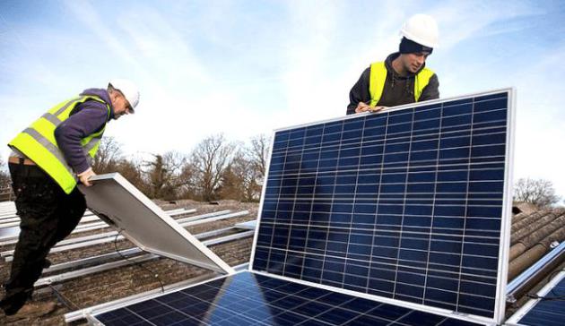
Solar Now Cheaper Than Fossil Fuels For Many Small Businesses.
EcoWatch has the story; here's the intro: "
Solar
power is the fastest-growing sourc eof electricity in the country, and
now mom and pop shops can take part in the boom. Solar panels are
usually seen on the roofs of residential buildings, schools, large
companies or government institutions, but now, SolarCity is expanding
its services to small and medium-sized businesses, or SMRs, the company
announced. This move essentially allows local businesses to cut ties to
their utility and save money against rising electricity costs with
renewable energy..." (photo credit:
flickr).
What It Feels Like To Go Viral. Here's an excerpt of a fascinating piece from
Pacific Standard: "
Let's
get some definitional housekeeping out of the way: There is no
pageviews threshold for what a piece of #content needs in order to, as
they say, “go viral.” It's a moving target that shifts from
person-to-person, organization-to-organization, on a monthly, even
daily, basis. If you normally have 2,000 daily readers, then you get
20,000, that's viral. If you're the New York Times and you get 20,000,
something has gone horribly wrong. Pageviews matter, but relativity
matters more..."
TODAY: Sunny, breezy, comfortable. Winds: NW 10-20. High: 83
FRIDAY NIGHT: Clear and pleasant. Low: 63
SATURDAY: Sunnier day of the weekend. Winds: W 10. High: 84
SUNDAY: Some sun, late-day T-storm risk. Wake-up: 63. High: 85
MONDAY: Blue sky, less humid again. Wake-up: 66. High: 81
TUESDAY: Pinch me. Remarkably nice! Wake-up: 61. High: near 80
WEDNESDAY: Less sun, stray T-shower possible. Wake-up: 64. High: 81
THURSDAY: Intervals of sun, few complaints. Wake-up: 62. High: 79
Climate Stories....
Jeb Bush: Humans Contribute to Climate Change. Is
the GOP taking baby-steps toward acknowledging the reality of man-made
climate change? It would appear so, based on Jeb Bush's recent
(encouraging) interview with Bloomberg, featured at
TheHill; here's the intro: "
GOP
presidential hopeful Jeb Bush says human activity is contributing to
climate change and the country has an obligation to work to stop it. “I
think it’s appropriate to recognize this and invest in the proper
research to find solutions over the long haul but not be alarmists about
it,” Bush said in an interview published
Thursday with Bloomberg BNA. “We should not say the end is near, not
deindustrialize the country, not create barriers for higher growth, not
just totally obliterate family budgets, which some on the left advocate
by saying we should raise the price of energy so high that renewables
then become viable,” he added..."
Step Outside - Climate Change is Here. Here's an excerpt of an Op-Ed from the Editorial Board at
The Sacramento Bee: "...
if
global warming doesn’t feel like a threat by now, it ought to. Last
week, 16 leading scientists joined the former lead climate scientist for
NASA in warning that glaciers in Antarctica and Greenland could melt 10
times faster than anyone thought. James Hansen, one of the first predictors of climate change – “alarmist and also right,” as Slate called him – reported that the goal we had all been told was safe, limiting global warming to a 2-degree Celsius temperature
increase, actually won’t begin to control the damage. In as little as
50 years, according to the study published last Thursday in the
open-access journal Atmospheric Chemistry and Physics, sea levels may rise 10 feet or more, inundating the world’s coastal cities..."
Before The Time of Global Warming, Spring Sprung Later. Here's a snippet from a story at
Inside Climate News: "...
According
to one of the largest troves of ecological data from the past, living
organisms are already responding to the rise in temperatures from global
warming. By digitizing more than 11,000 records
from the 19th century that chronicled the flowering of plants and
trees, the springtime arrival of migrating birds, and the annual onset
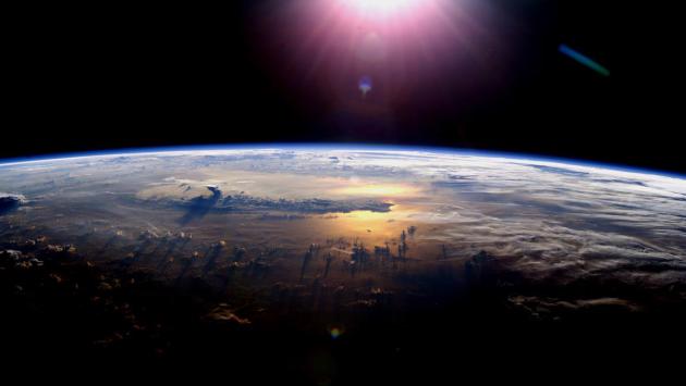
of frog mating calls, researchers at the Hawthorne Valley Farmscape Ecology Program in Harlemville, N.Y. have shown that spring is arriving as much as 14 days early as climate change accelerates..." (File photo: NASA).
Read more here: http://www.sacbee.com/opinion/editorials/article29473891.html#storylink=cpy
New Report from Anti-Poverty Group Debunks Claim That Coal Is Good For Poor People. Here's the intro to a story at
ThinkProgress: "
The
coal industry and its supporters often argue that coal is still a
relevant energy source because it’s cheap, and cheap electricity reduces
energy poverty. But on Tuesday, Oxfam Australia directed an entire report
to Australia’s government, saying that for the one billion people
living without electricity, coal is more expensive than renewable energy
sources. “Renewable energy is a cheaper, quicker, and healthier way to
increase energy access,” the report states. “Coal is ill-suited to
meeting the needs of the majority of the people living without
electricity...”
On The Economics Of The End of The World As We Know It.
At the risk of sticking a toe into a puddle of gloom and doom - how do
we measure and price risk, including the risk of cataclysmic changes
brought on by climate change? Here's an excerpt from
The Economist: "...
However,
estimating these benefits means that we need to determine the value of a
reduction in preventing a possible future catastrophic risk. This is a
thorny task. Martin Weitzman, an economist at Harvard University, argues
that the expected loss to society because of catastrophic climate
change is so large that it cannot be reliably estimated. A cost-benefit
analysis—economists’ standard tool for assessing policies—cannot be
applied here as reducing an infinite loss is infinitely profitable..."
Defense Department to Congress: Global Warming is a "Present Security Threat". My
youngest son flies helicopters for the Navy - I can tell you for the
fact that the U.S. Navy is taking climate change, climate volatility and
rising seas very seriously. Andrew Freedman at
Mashable has the story - here are a few snippets that got my full undivided attention: "
For
the first time, the U.S. Department of Defense has detailed what it
views as its greatest challenges related to climate change. In a report
to Congress, the Defense Department said that global warming poses a
"present security threat, not strictly a long-term risk." The report,
delivered to the Senate Appropriations Committee on Tuesday and publicly released Wednesday,
further stated the Defense Department is "already observing the impacts
of climate change in shocks and stressors to vulnerable nations and
communities," including in the United States, the Arctic, Middle East,
Africa, Asia and South America.....
Studies published in June
found that humanity is rapidly depleting a third of the world's largest
groundwater aquifers, with the top three most stressed groundwater
basins in the political hotspots of the Middle East, the border region
between India and Pakistan, and the Murzuk-Djado Basin in northern
Africa..."
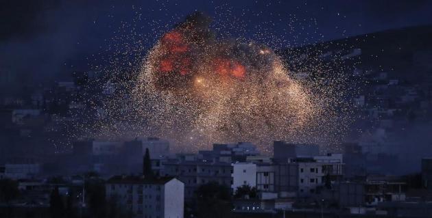
Photo credit above: "
Thick smoke and
flames from an airstrike by the U.S.-led coalition rise in Kobani,
Syria, as seen from a hilltop on the outskirts of Suruc, at the
Turkey-Syria border, Monday, Oct. 20, 2014." Image: Lefteris Pitarakis/Associated Press.
The full report from the Defense Department is at
defense.gov. See also:
Global warming helped trigger Syria's civil war.
Climate Change Will Cause Increased Flooding in Coastal Cities. Here's an excerpt from Forbes: "...
Another paper, published yesterday in Nature, had less fanfare than the Hansen paper, but shows the severe danger of flooding in coastal regions,
particularly in the United States. This risk isn’t directly from
sea-level rise, but from the intensification of storm surges and
increased precipitation that are secondary effects of climate change.
Flooding risk in any particular place depends on a number of factors:
the flatness of land right by the water, how steep the continental shelf
is off the coast, the number and severity of storms, etc. That’s why
much of the state of Florida is at greater risk than coastal cities in
California. As the Nature paper shows, heavier rainfall combines with
storm surges, the rush of water toward the shore during major storms, to
amplify flooding..."
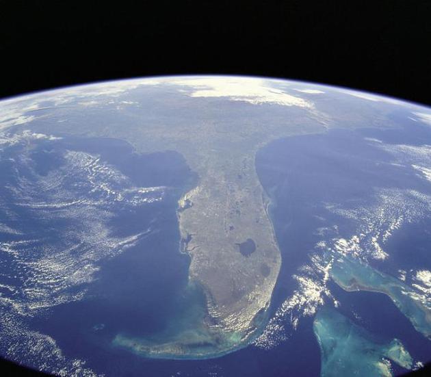
Image credit above: "
Florida
as seen from the Space Shuttle in 1998. Flooding from climate change is
threatening much of the coastline, including major cities in Florida." (Credit: NASA)
Get Ready for Ugly As Markets Begin To Deal With Climate Crisis. Here's an excerpt of a story at
EcoWatch that made me do a double-take: "
Advocates of “market-based” climate
solutions paint pastel pictures reflecting smoothly adjusting
macro-economic models. Competitive markets gradually nudged by carbon
pricing glide into a low carbon future in a modestly disruptive fashion,
much as sulfur pollution from power plants was scaled back in the
1990’s. But commodity markets for oil and gas don’t work that way. These
real markets are poised to savagely strand assets, upset expectations,
overturn long established livelihoods and leave a trail of wreckage
behind them—unless climate advocates start owning the fruits of their
own success and preparing for the transition. Schumpeter’s destructive
engine of capitalism is about to show its ugly side..." (File photo: Shutterstock).






No comments:
Post a Comment