Meteorologist Paul Douglas writes about Minnesota weather daily, trying to go beyond the "highs" and "lows" of the weather story to discuss current trends and some of the how's and why's of meteorology. Rarely is our weather dull - every day is a new forecast challenge. Why is the weather doing what it's doing? Is climate change a real concern, and if so, how will my family be affected? Climate is flavoring all weather now, and I'll include links to timely stories that resonate with me.
Wednesday, July 15, 2015
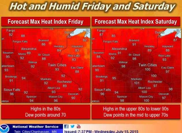
Heat Index Near 100 by Saturday - Minneapolis #2 on "Climate Disruption Index"??
81 F. high in the Twin Cities Wednesday. 84 F. average high on July 15. 72 F. high on July 15, 2014.
.01" rain fell at MSP International Airport Wednesday.
July 15, 1980:
Straight-line winds of nearly 100 mph causes enormous damage, mainly in
Dakota County. 43 million dollars in damage was reported and 100
thousand people were without power.
July 15, 1881:
A family of tornadoes, likely up to F5 in strength, was on the ground
for 40 miles in southern Minnesota. Five farms had every building
completely swept away. One of the tornadoes was about to pass just of
the west of New Ulm, but then turned and plowed into the town. Twenty
people were killed along the entire path length, including 6 in New Ulm.
Nocturnal Mysteries
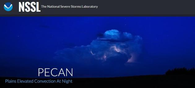
Tim Morin from Shorewood asked me what NOAA was doing flying a WP-3D Orion "Hurricane Hunter" aircraft into Sunday night's developing derecho above Minnesota. I checked with Twin Cities National
Weather Service boss Dan Luna, who reminded me of "PECAN", the Plains Elevated Convection at Night
project now underway. We have a reasonably good grasp of afternoon
instability T-storms; how and why they form. But nighttime storms are
more problematic, responding to different dynamics, like low level jet
stream winds and boundaries leftover from daytime convection. Some of
Minnesota's heaviest (and most fickle) rains develop at night along warm
fronts from May to July.
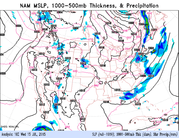
NAM guidance prints out an inch of rain
from storms today but the ECMWF (European) model pushes the heaviest
storms south, over Iowa. Comfortable 70s today give way to upper 80s Friday and low 90s Saturday, when a dew point in the 70s will push the heat index into the oh-zone.
Another bumper crop of sprouting thunderstorms late Saturday gives way to a puff of slight relief Sunday as humidity levels drop and skies clear.
Moderately warm weather lingers the next 2 weeks - no sign of any extended heatwaves. It'll be just warm enough.
Free Interactive Weather.
If you are mourning the demise of My-Cast on the web (it's still
available as an app!) there are other alternatives, including what we're
currently doing with Aeris Weather.
Full disclosure: a previous company, Digital Cyclone, now owned by
Garmin, launched My-Cast, first on the web 15 years ago and then on
smart phones. Plug in your zip code into the Aeris link and you'll get a
variety of forecasts and maps, including an interactive capability that
has some powerful options. (note: try the full screen mode to get the
full effect and full resolution).
Shocker: More T-storms Brewing.
The risk of heavy/widespread T-storms has dropped for Thursday, but
models are now printing out more rain for Saturday, especially late in
the day as a slightly cooler, drier airmass approaches for Sunday. Some
1-2" amounts can't be ruled out, especially far northern Minnesota.
Check out Hurricane Delores in the eastern Pacific, forecast to veer out
to sea. As of late last night sustained winds were 125 mph. NAM
accumulated rainfall: NOAA and AerisWeather.
Thundery Lumps.
Scattered showers and T-storms continue to flare up along a warm
frontal boundary, juiced by dew points in the 70s by Friday and
Saturday. Expect a drop in dew point Sunday with more sunshine and a
lowered risk of thunder. 84-hour NAM guidance: NOAA.
On Gull Lake, Sunday Storm Uproots Trees, Lives.The Star Tribune has more follow-up on Sunday night's severe derecho that swept across the Brainerd Lakes area; here's an excerpt: "...The
storm pushed trees on top of cars, overturned boats, twisted metal
decks and blew the roof off a building at Madden’s. Madden’s and
Cragun’s were shut down by the storm and remained without power Tuesday
night. Dutch Cragun, owner of Cragun’s, said this is the first time
weather has forced the resort to close. “This is the worst, in my
experience, in 75 years since my dad started building Cragun’s in 1940,”
he said. Madden’s and Cragun’s resorts have worked together, competed
against one another and grown into major vacation enterprises. The
resorts have kept their doors open even during wartime, Cragun said..."
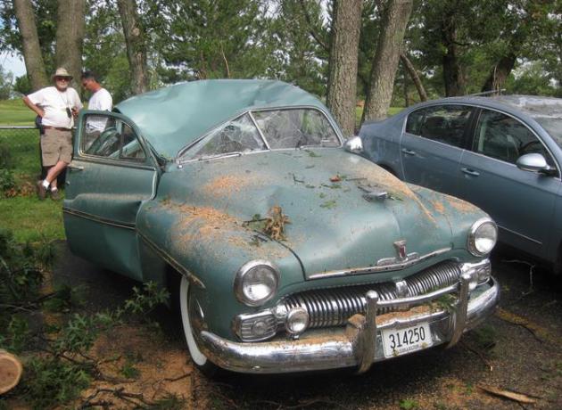
Photo credit above: Bruce Nelson. "At
Cragun's Resort, trees fell on five classic cars owners had brought to a
regional meet. One tree crushed the roof of a 1950 Mercury."
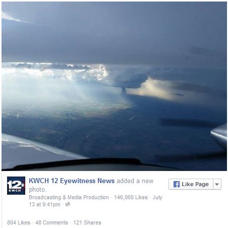
From Drone and Plane, This Remarkable Kansas Tornado Is A Sight To Behold. I've never seen a tornado from this perspective. The Washington Post's Capital Weather Gang has the story and video clips, which are quite amazing - luckily nobody was injured by this fat, "stovepipe" tornado: "...A
remarkable, large stovepipe tornado touched down in Kansas on Monday
evening, seen from land and sky as it barreled across the landscape,
kicking up dirt and debris high into the air. It was the only tornado
reported on Monday. The only show in town — and it put on quite a show
when it touched down around 7:30 p.m. The tornado narrowly avoided the
city of Hutchinson, Kan., population 42,000..."
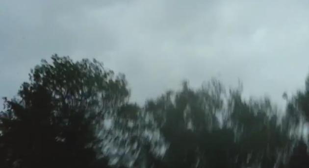
A Taste Of What Sunday Night's Storm Was Like. Thanks to laekoth at YouTube
for sharing the footage he took Sunday evening. If you listen carefully
you can hear the snapping of trees above the roar of the wind. I was up
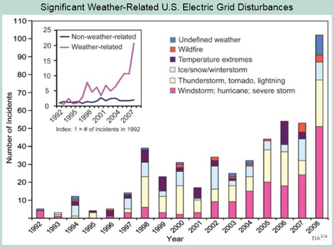
there - it was an incredible (and costly) display. Troubling Severe Weather Trends With The Grid. A 10-fold increase in incidents on the USA power grid triggered by extreme weather - according to the Energy Information Administration. Here's an excerpt from a summary at The U.S. Global Change Research Program: "The
number of incidents caused by extreme weather has increased tenfold
since 1992. The portion of all events that are caused by weather-related
phenomena has more than tripled from about 20 percent in the early
1990s to about 65 percent in recent years. The weather-related events
are more severe, with an average of about 180,000 customers affected per
event compared to about 100,000 for non-weather-related events (and
50,000 excluding the massive blackout of August 2003). The data
shown include disturbances that occurred on the nation’s large-scale
“bulk” electric transmission systems. Most outages occur in local
distribution networks and are not included in the graph. Although the
figure does not demonstrate a cause-effect relationship between climate
change and grid disruption, it does suggest that weather and climate
extremes often have important effects on grid disruptions. We do know
that more frequent weather and climate extremes are likely in the
future,which poses unknown new risks for the electric grid." Image Reference above: EIA"
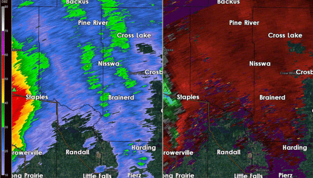
Sunday Night's Brewing Derecho.
Thanks to Aeris Weather meteorologist Todd Nelson for capturing
reflectivity (upper left) and velocity fields (upper right) from the
Duluth National Weather Service Doppler. The rotating supercell
thunderstorms that swept east from Fergus Falls to Wadena and Brainerd
whipped up 70-80 mph winds in a fairly wide swath between Brainerd and
Nisswa, cutting down hundreds, possibly thousands of trees.
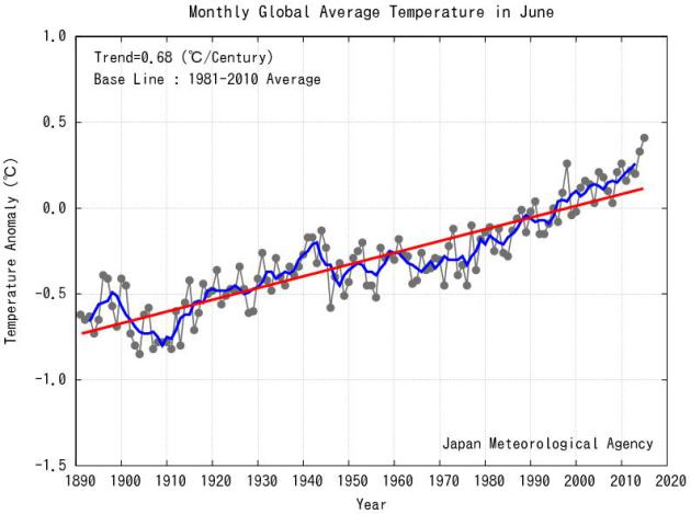
Globally: Warmest June Since 1891. Here's an excerpt from JMA, the Japanese Meteorological Agency: "The
monthly anomaly of the global average surface temperature in June 2015
(i.e. the average of the near-surface air temperature over land and the
SST) was +0.41°C above the 1981-2010 average (+0.76°C above the 20th
century average), and was the warmest since 1891. On a longer time
scale, global average surface temperatures have risen at a rate of about
0.68°C per century..."
El Nino Doesn't Guarantee California Gets Drought-Relieving Rain.Bloomberg Business has the article; here's the introduction: "El Nino can mean devastation
for some parts of the world. For California, this year, it means hope.
The hope is the state will get drenched and a four-year drought will
release its grip. After all, Texas and Oklahoma got soaked in May and
June and their multiyear droughts just faded away. For that to happen in
California would probably be a long shot. “They didn’t get into this
drought in one year and it takes time,” said Brian Fuchs, a
climatologist at the National Drought Mitigation Center in Lincoln, Nebraska. “Texas and Oklahoma being the exception, typically you come out of it just as slow as you went into it...”
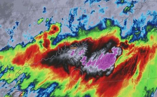
Massive El Nino Growing, Say Models.
Yes, it may be an interesting winter season, especially for California.
Historic drought to historic flooding in the meteorological blink of an
eye? We'll see, but the warm phase in the Pacific looks more impressive
with each passing week. Here's the intro to a story at USA TODAY: "There is growing evidence California could see an even stronger
El Niño event this winter than the 1997 one that caused massive
flooding across Northern California. Stunning images from Japan's
Himawari 8 Weather Satellite, just activated Tuesday, show what could
become a historic El Niño in full bloom. "Almost all models are showing
consistency that we're seeing a stronger and stronger tendency for that
to hold in place through the winter season. It could rival that of
1997," News10-KXTV Chief Meteorologist Monica Woods said..."
Image credit: "The Himawari-8 Weather Satellite in Japan shows a possible historic El Nino in full bloom on Wednesday, July 8, 2015." (Photo: Himawari-8 Weather Satellite Image).
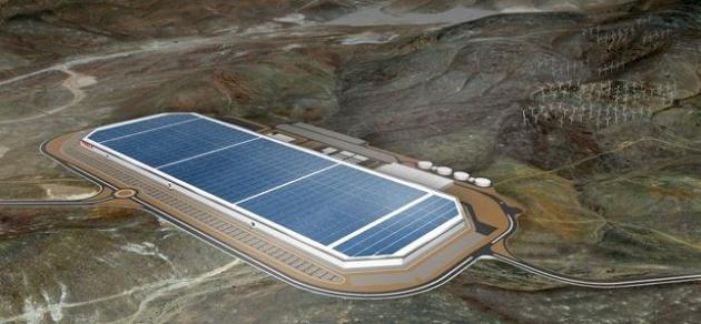
Does Elon Musk's Tesla Model S "Signal The Beginning Of The End For Oil?"EcoWatch has the story; here's a clip: "...At
least that's the word on the street after Story County official Dean
Haymore revealed that the electric vehicle/battery maker initially
bought a thousand acres to start with, then recently swoooped up another
1,200 acres and another 350 acres on top of that. As Tech News Today
writes, Tesla "initially intended to purchase 10 million square-feet of
land for its Gigafactory, but after recent plans of acquisitions, it
seems Tesla will end up with more than 24 million square-feet of land,
making in the largest factory in the world..."
Image credit above: "Tesla broke ground on its Gigafactory in June 2014 outside Sparks, Nevada." Photo credit: Tesla Motors
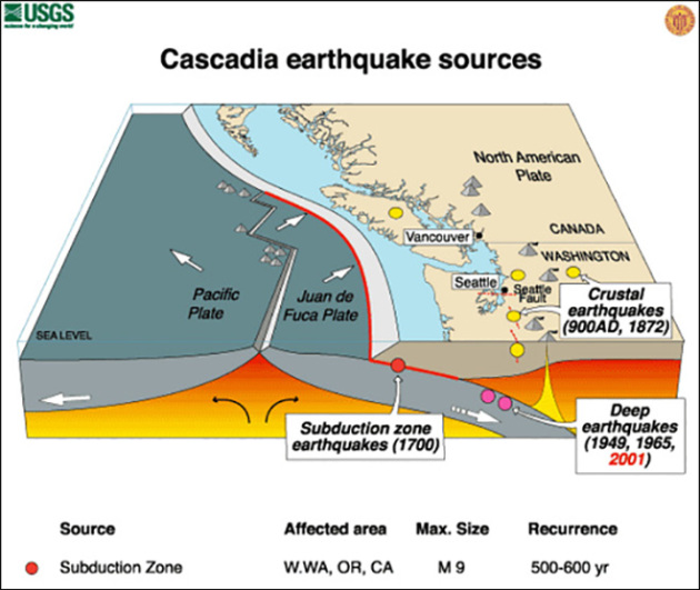
The Really Big One.
Much of California is earthquake country, but a quake along the San
Andreas fault may pale in comparison to what could happen in the Pacific
Northwest. I sent this to my oldest son, who lives in Seattle - here's
an excerpt from The New Yorker: "...By
the time the shaking has ceased and the tsunami has receded, the region
will be unrecognizable. Kenneth Murphy, who directs FEMA's Region X,
the division responsible for Oregon, Washington, Idaho, and Alaska,
says, “Our operating assumption is that everything west of Interstate 5
will be toast.” In the Pacific Northwest, everything west of Interstate 5
covers some hundred and forty thousand square miles, including Seattle,
Tacoma, Portland, Eugene, Salem (the capital city of Oregon), Olympia
(the capital of Washington), and some seven million people. When the
next full-margin rupture happens, that region will suffer the worst
natural disaster in the history of North America..." (Image above: USGS and KOMO News).
All The Ways Hackers Will Try To Kill You In The Future. If you're feeling insecure or paranoid to begin with skip this one, courtesy of Hopes & Fears: "...Hacking
into city streetlight systems to cause slowdowns and accidents. In
2006, two LA engineers were able to infiltrate the traffic light system,
despite being locked out, and increase red light times at key
intersections across the city, deliberately clogging key intersections.
More recently, researchers found that hacking into these traffic systems
is incredibly easy, as many have open wireless and use the default
passwords. RedYellowGreen is probably up there with 1234 as far as
secure passwords go..."
TODAY: Unsettled, few T-storms around. Locally heavy rain. WInds: SE 10-15. High: 75
The Weather.com Climate Disruption Index. A
number of esteemed climate scientists who I respect weighed in on this
project, ranking the U.S. cities most vulnerable to climate volatility.
Minneapolis came in second, behind New Orleans, and St. Paul weighed in
at number 8. There's little doubt we're already being impacted by
greater swings in drought and flood, more whiplash as ecosystems
transition slowly northward with rising temperatures and warming
winters, but I can understand why a difference of 12 miles would make a
difference between number 2 and number 8 on the list. That's a
head-scratcher. Here's an excerpt at weather.com: "Minneapolis
could get pummeled from a lot of different angles, making it number 2
on our list. The city itself will be a good deal hotter than rural
places close by. It has seen precipitation increase by almost 40 percent
since 1958, a trend expected to continue. Drought here will also
continue to worsen. The city isn’t waiting around for these changes; in
2013, it implemented a sustainability plan
that includes reducing energy consumption by 17 percent and using
renewable forms of energy to meet 10 percent of its needs by 2025..."
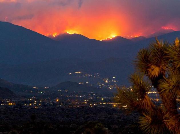
Wildfires Are Happening More Often And In More Place. According to new research highlighted at Smithsonian average fire season length has increased by a fifth, and the area impacted has doubled. Here's an excerpt: "...In
places where wildfires most commonly occur, fire danger indices have
been developed that use local weather variables to predict the risk that
a fire will spark and spread. Matt Jolly, an ecologist with the U.S.
Forest Service, and his colleagues combined several of these indices
with surface weather data to explore how fire seasons have changed over
the last 35 years. Globall, average fire season length increased by 18.7
percent, the researchers report today in Nature Communications..."
Photo credit above: "Flames and smoke cover the hillsides near Yucca Valley in California during a June wildfire." (NPS/Brad Sutton).
How Climate Change Could Affect Your Finances. US News has the story - here's a snippet: "...So you could have trouble selling your house
and perhaps keeping your job. And while that sounds like an alarmist
conclusion, and it may well be, a recent report released by the
Environmental Protection Agency called, "Climate Change in the U.S.:
Benefits of Global Action," concluded that by the end of the century,
the U.S. could experience up to $180 billion in economic losses due to
drought and water shortages. Homeowners insurance
will rise. In June, a study published in the U.K. journal Nature
Climate Change concluded that man-made global warming is responsible for
about 75 percent of all hot-temperature extremes worldwide over the
past 100 years as well as 18 percent of heavy rainfall..."
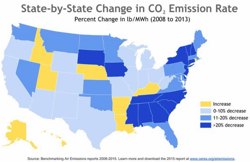
States Cut Power Plant Emissions Ahead of New EPA Rule. There
is an important decoupling going on. Translation: you can still have
economic growth while reducing CO2 emission levels. Here's an excerpt
from Climate Central: "...Coal-fired power plants are the largest
source of the greenhouse gas emissions causing climate change, but their
dominance has begun to wane as federal emissions standards have forced
some coal plants to shut down
and the U.S. shale gas boom has brought natural gas prices down. In
April, natural gas, which releases roughly half the carbon dioxide as
burning coal, surpassed coal
as the dominant fuel for electric power generation in the U.S. for the
first time in history. Nationwide, carbon dioxide emissions rates from
electric power plants were 14 percent higher than 1990 levels, but
declined 12 percent between 2008 and 2013. Among the nation’s largest
utilities, coal accounts for nearly four-fifths of their carbon
emissions. Natural gas accounts for just one-fifth, according to the
report..." (Map: CERES).
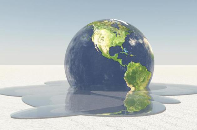
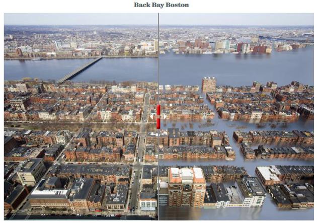
Water World. Here's what 25 teet of sea-level rise would do to some of America's coastal attractions, courtesy of onEarth: "...A paper published in Science
last week found that even if we keep global temperature change below
the two-degree Celsius target, sea levels could still rise by at least
20 feet. If that sounds like a lot, it’s because it is. And these before and after images of American landmarks plus 25 feet of water, created by visual artist Nickolay Lamm with data developed by Climate Central, say it all..."
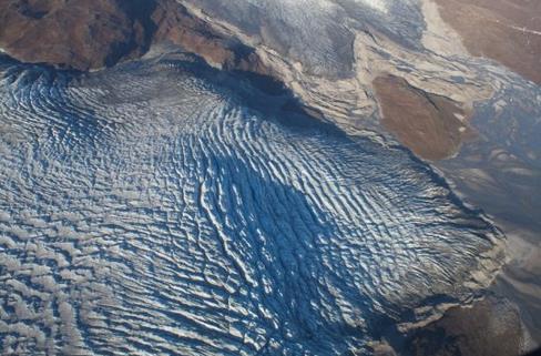
Rainfall Drives Rapid Melt, Flow Of The Greenland Ice Sheet.
Greenland has been melting faster than those "alarmist" climate
scientists have been predicting for 30 years. Probably no need to worry -
unless you live within 10-20 feet of the ocean. Here's an excerpt from ScienceDaily: "According
to a new study published in Nature Geoscience, the Greenland ice sheet
has been shown to accelerate in response to surface rainfall and melt
associated with late-summer and autumnal cyclonic weather events. Samuel
Doyle and an international team of colleagues led from Aberystwyth
University's Centre for Glaciology combined records of ice motion, water
pressure at the ice sheet bed, and river discharge with surface
meteorology across the western margin of the Greenland ice sheet and
captured the wide-scale effects of an unusual week of warm, wet weather
in late August and early September, 2011..."
Photo credit above: "Crevassed glacier terminus in West Greenland." Credit: Sam Doyle.
*
University of St. Thomas professor and climate scientist John Abraham
has additional perspective on what's happening in Greenland, courtesy of
The Guardian.
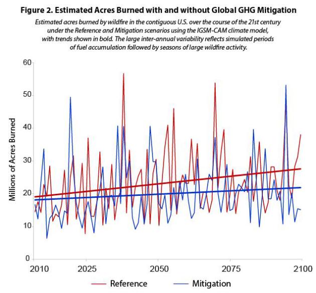
The Wild(fire) Side of Climate Change. On
the path we're on now wildfires will become even larger, more intense
and harder to knock down in the years to come. Here's an excerpt from Earth Gauge: "...Climate
models predict that an increase in greenhouse gas emissions will result
in even drier and warmer conditions and larger and longer-lasting
wildfires. The graphic below from the U.S. EPA’s new report, Climate Change in the United States: Benefits of Global Action,
shows the estimated acres burned with (mitigation) and without
(reference) global greenhouse gas emissions reductions over time.
According to EPA, if greenhouse gas emissions are reduced over the
course of the 21st century, the amount of U.S. forested land that can be
prevented from burning by 2100 will be two to three times the size of
California, saving $8.6 to $11 billion in wildfire response costs and
$3.4 billion in fuel management costs on conservation lands. Without
reductions over the course of the 21st century, approximately 5.3
million more acres of forested land (the size of Massachusetts) in the
U.S. is projected to burn each year at the end of the century compared
to today..."

No comments:
Post a Comment