72 F. high temperature in the Twin Cities Thursday.
84 F. average high on July 16.
77 F. high on July 16, 2014.
.16" rain fell at MSP International Airport yesterday.
June 17, 2001:
Lightning struck a Minnesota National Guard field training site located
in Camp Ripley. Nearly two dozen Marine Corps reservists were sent to
hospitals. Most were released after treatment.
June 17, 1952:
5.20 inches of rain fell in 3 1/2 hours at Moose Lake. Numerous
basements were flooded and Highway 61 was impassable at Willow River.
June 17, 1934: Frost damages crops across the north with 34 in Baudette and Roseau.
Big SwingerNo
wonder why we're all so confused. I fear Mother Nature needs to be
medicated. I swear my furnace kicked on yesterday. Air conditioners will
grind away today and
Saturday
as the heat index rises well into the 90s. Head-snapping changes -
factoring heat index today will feel about 30 degrees warmer than
yesterday.
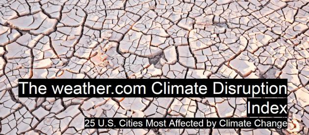
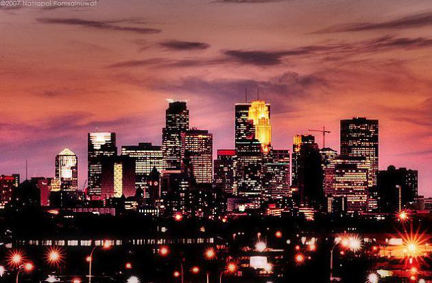
I was surprised to see Minneapolis* come in at number 2 on The Weather Channel's
Climate Disruption Index,
the top 25 U.S. cities impacted by climate change. Authored by leading
climate scientists Minneapolis was second only to New Orleans, which
made me do a triple-take. They note the 40 percent increase in
precipitation since 1958, coupled with more severe droughts.
In a word, more "whiplash".
Tell
that to residents of Brainerd. The Duluth National Weather Service
estimates straight-line winds may have reached 100 mph last Sunday,
literally snapping trees. A surreal sight. It was a severe downburst
within a much larger developing derecho that formed over western and
central Minnesota and then dived 700-800 miles southeast, creating wind
damage as far away as Kentucky the next day.
Yesterday's cool, wind-whipped drizzle gives way to hazy sun today with a shot at 90F. T-storms may rumble in
Saturday morning, but a push of Canadian air drops dew points into the comfortable 50s
on Sunday.
Expect a run of 80s next week with sporadic storms - we may be well
into the 90s the weekend of June 25-26, if ECWMF guidance is to be
believed.
Lately I'm happy just to savor a quiet day.
*
What do I think of the ranking? I'm not a climate scientist, but I am
tracking the meteorological changes, shifts and trends that are
emerging. Frankly, I'd be far more nervous living in Miami (sea level
rise) or Las Vegas (running out of water) or Sacramento (brush fires)
than I would here in Minneapolis. And if Minneapolis ranks #2 why is St.
Paul #8. They are 12 miles apart. That doesn't make sense (to me).
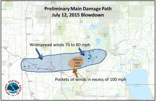
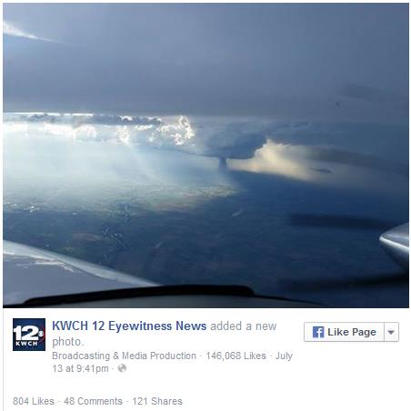
 Damaging Downburst Within Developing Derecho Sunday Night
.
The Brainerd Dispatch
has an update on the ferocity of winds that tore into the Brainerd
Lakes area; a supercell-spawned downburst, a sudden and severe downdraft
of rain and hail-cooled air descending from the severe thunderstorms
that hit the ground, spread out, and produced winds as high as 100 MPH
over Pillsbury State Park just northwest of Brainerd. 100 MPH is
equivalent to the winds within an EF-1 tornado. Here's an excerpt: "..
.A
meteorologist assessed the damage in the lakes area before determining
the downburst, which may also be called straight-line winds, was the
factor here not a tornado. The main damage path was 8 miles long and 3
miles wide..."
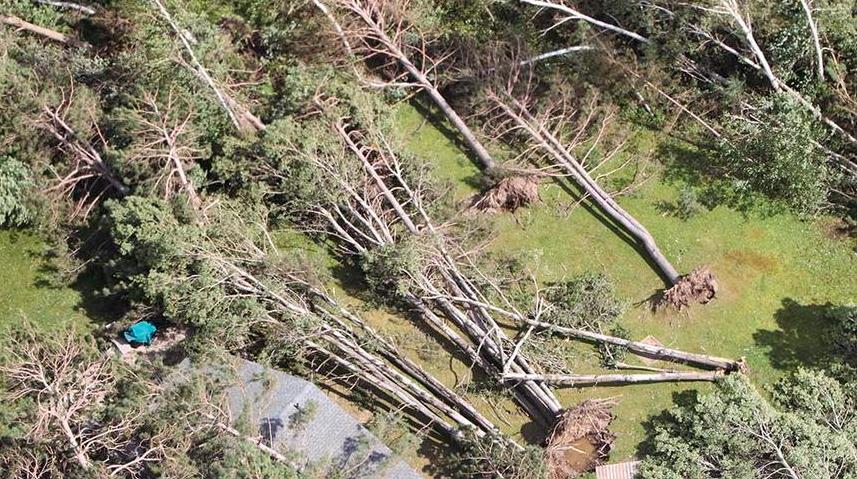
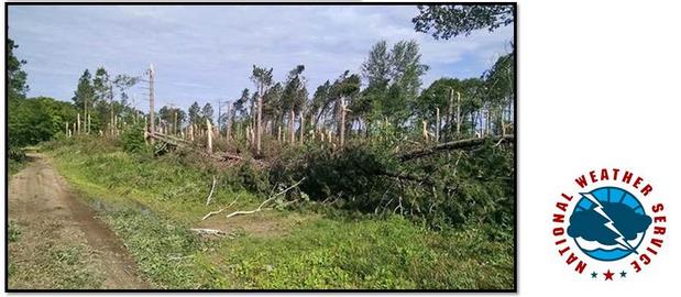
Photo credit above: "
A swath of
trees lay blown over Monday after a super cell thunderstorm hit the
Brainerd lakes area with near category 1 hurricane force winds." (Kelly Humphrey, Brainerd Dispatch)
100 MPH Straight-Line Winds In Sunday's Storms near Brainerd?
The damage swath is consistent with a downburst, an extreme downdraft
reaching the ground and spreading out into damaging straight-line winds.
Here is a preliminary damage report from the
Duluth office of the National Weather Service: "
On
the evening of July 12th, 2015 a line of severe storms brought
significant straight line winds to the southern portions of Cass and
Crow Wing counties in north central Minnesota. An automated weather
station in Brainerd, MN recorded a peak wind of 65 mph during the storm.
Most of the storm damage in the Brainerd area was consistent with winds
in the 70-80 mph range. However, there were pockets of more devastating
tree damage, mainly in the Pillsbury State Forecast area northwest of
Brainerd, MN. Based on aerial photos provided by the Minnesota
Department of Natural Resources, prelinary assessments suggest wind
speeds in excess of 100 mph were likely in this area..."
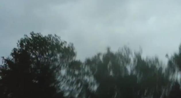
Extreme Tree Damage.
It's one thing for sustained straight-line winds to blow trees over,
especially when the soil is wet. But having trees snap off 5-15 feet
above the ground? That's more consistent with a downburst or microburst
with winds approaching or even exceeding 100 mph. Photo: DLH NWS.
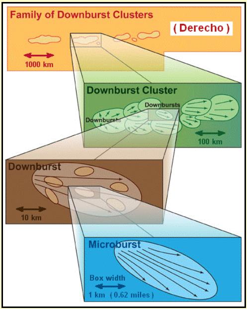
Difference Between a Downburst and a Derecho?
You can have downbursts, swaths of especially violent straight-line
winds, within a much larger derecho, but not the other way around.
Here's an excerpt of more than you ever wanted to know about the
phenomena from
NOAA SPC: "...
The
winds associated with derechos are not constant and may vary
considerably along the derecho path, sometimes being below severe limits
(57 mph or less), and sometimes being very strong (from 75 mph to
greater than 100 mph). This is because the swaths of stronger winds
within the general path of a derecho are produced by what are called
downbursts, and downbursts often occur in irregularly-arranged clusters,
along with embedded microbursts and burst swaths. Derechos might be
said to be made up of families of downburst clusters that extend, by
definition, continuously or nearly continuously for at least 240 miles
(about 400 km)..."
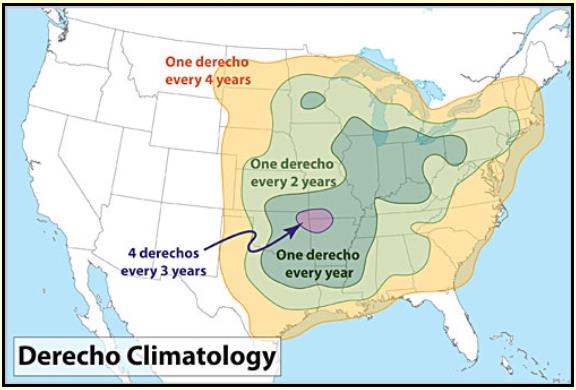
Derecho Climatology.
On average most Minnesotans experience a derecho once every 2 years,
looking at long term historical data. It's interesting (at least to me)
that St. Cloud and the Twin Cities have a slightly greater risk than
Rochester or even Des Moines, but the risk increases as you go
south/east into the Ohio Valley and Lower Mississippi River Valley.
Source: NOAA SPC.
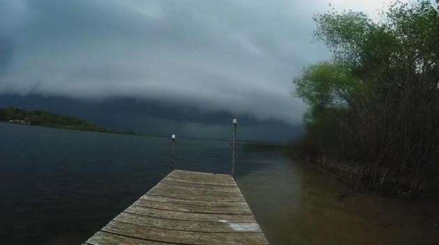
Remarkable Footage.
Thanks to Bryce Johnson, who used a GoPro camera on North Long Lake
Sunday night to get an amazing timelapse of the developing derecho as it
passed overhead. Straight-line winds probably approached 75-80 mph at
times with this system in the North Long Lake area. Check it out for
yourself on
Vimeo.
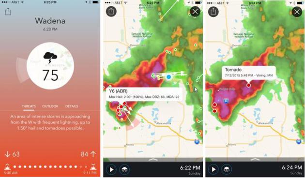
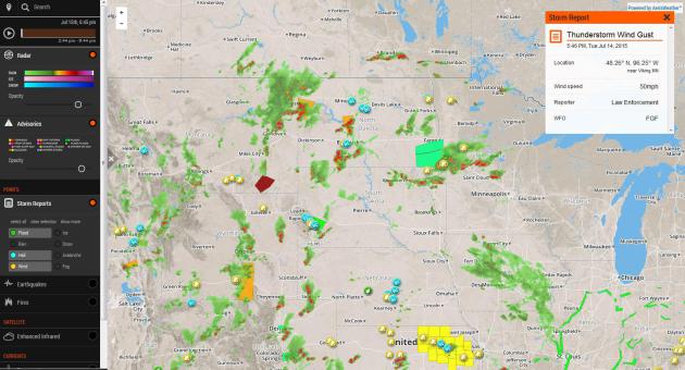
Tracking The July 12 Super-Storm.
I was at our cabin near Breezy Point Sunday evening, tracking the
severe storms on my iPhone using my company's new weather app:
Aeris Pulse
(which will set you back a whopping 99 cents, of which I get
approximately....zero). Not only do you get a running narration of
threats nearby but you can see detailed Doppler radar information,
direction of storm cells, hail size and rotation, along with storm
reports, wind data and the ability to keep track of multiple locations.
Oh, you can see hour by hour forecasts and the 7-Day too, The phones
came in handy, for information and flashlight capabilities. The power
went out but somehow cell towers stayed up and my phone was the only way
I could keep in touch.
ADVERTISEMENT
More
than 100mm of rain fell on the Norwegian village of Ogndal, an amount
rarely seen outside the tropical rainforests of Brazil or Indonesia. The
downpour, which left farm animals petrified and meteorologists
scratching their heads, is believed to have shattered records for the
area,
the Local has reported.
A Taste Of What Sunday Night's Storm Was Like. Thanks to
laekoth at YouTube
for sharing the footage he took Sunday evening. If you listen carefully
you can hear the snapping of trees above the roar of the wind. I was up
there - it was an incredible (and costly) display.
Dear Mr Douglas,
Thank
you for your article in the Star Tribune on the "Derecho". My husband
and I were in a small cabin on East Gull Lake at Madden's when the
Storm hit. We were with our two little girls ages 2 and 4. We didn't
realize the risk of this particular Storm until it was too late to take
shelter at main lodge. The sound we could hear moving closer and closer
to our cabin, I was convinced was a tornado. It was a very distinct
sound- my husband and I have never experienced such fear. We were lucky
that everything fell around the cabin and although there was severe
destruction outside and the cabin shook like crazy- it kept us unharmed!
The sound was all we had to measure the path it could be taking. We
can see a path that goes right past our cabin. We have photos and video
of our experience but nothing of the 30 minutes we spent in the bathtub
of the cabin before moving to the most interior spot in the cabin
between the bed and a wall. I'm also 7.5 months pregnant so my instincts
are in full force. I'm finding it very frustrating that nobody can
confirm we experienced what we know was a tornado. Please share with me
your opinion. It would be so appreciated. It was literally the most
terrifying moments in my life. And complete powerlessness over the force
of nature. Thank you. - Ann Berg
Ann -
there is no confirmation of a tornado in the Gull Lake area Sunday
evening, but it was a developing derecho with severe straight-line
winds, possibly in excess of 70-80 mph for the better part of 5-10
minutes, capable of bringing down big trees. Closer to Pillsbury State
Forest winds may have topped 100 mph in a violent downburst, but the
damage and debris field is consistent with straight-line winds, not
tornadoes. I was at our cabin on Pelican Lake for the event and I can
confirm the roar of that storm as it came through. Awe-inspiring - and
terrifying.
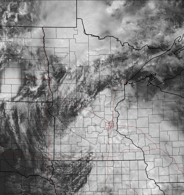
Drizzle and Thunder.
The same disturbance that sparked heavy T-storms and flash flooding
over Iowa spread stratus, steady rain and drizzle into southern and east
central Minnesota yesterday - typical for October or late March, but a
little odd coming in mid-July. Farther north and west where the sun came
out instability T-storms sprouted, some heavy. Thursday PM visible
loop: NOAA and AerisWeather.
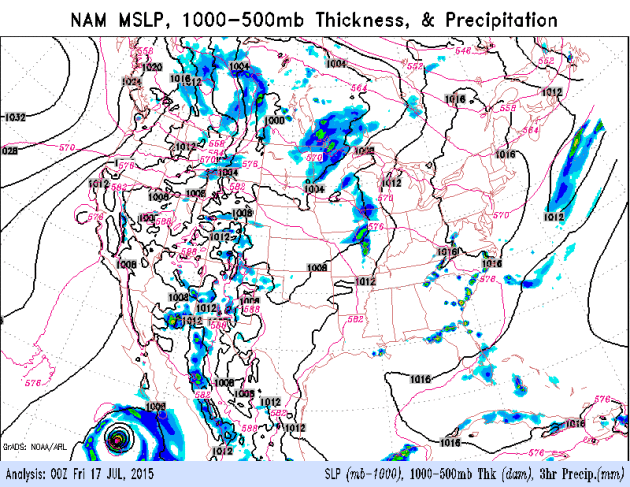
Keep An Eye on Saturday Morning.
NAM guidance is fairly consistent, pulling some strong T-storms across
the state of Minnesota early Saturday. Skies should clear out by
afternoon with highs near 90F; a dip in humidity and dew point Sunday as
a weak northerly breeze kicks in. Model data: NOAA.
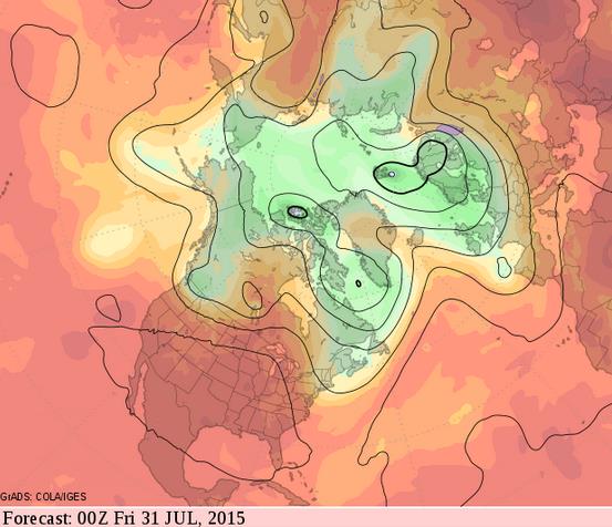
A Hot End to July?
GFS guidance, looking out nearly 2 weeks, shows a semi-permanent ridge
of high pressure over the Plains, with potentially record heat from
Denver and Kansas City to Atlanta. If the model verifies highs will
approach or top 90F as far north as the Twin Cities and Chicago.
From Drone and Plane, This Remarkable Kansas Tornado Is A Sight To Behold. I've never seen a tornado from this perspective. The Washington Post's
Capital Weather Gang has the story and video clips, which are quite amazing - luckily nobody was injured by this fat, "stovepipe" tornado: "...
A
remarkable, large stovepipe tornado touched down in Kansas on Monday
evening, seen from land and sky as it barreled across the landscape,
kicking up dirt and debris high into the air. It was the only tornado
reported on Monday. The only show in town — and it put on quite a show
when it touched down around 7:30 p.m. The tornado narrowly avoided the
city of Hutchinson, Kan., population 42,000..."
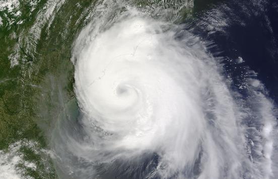
4 Reasons The Atlantic Hurricane Season Has Been So Quiet - And Is Likely To Stay That Way. Here's an excerpt from a good post at
The Capital Weather Gang: "...
The
lazy summer comes as no surprise to seasonal hurricane forecasters who
all predicted a relatively inactive season before it began June 1. NOAA’s forecast in late May called
for a 70 percent chance of a below-average season, with six to 11 named
storms, three to six of which could become hurricanes, and up to
two major hurricanes. It was the highest probability of a below-average
season that NOAA had ever forecast..."
Image credit above: "
The
first hurricane of the 2014 season made landfall in North Carolina. The
U.S. has had no such hurricane landfall this year, nor any hurricane
development in the Atlantic Ocean." (NASA).
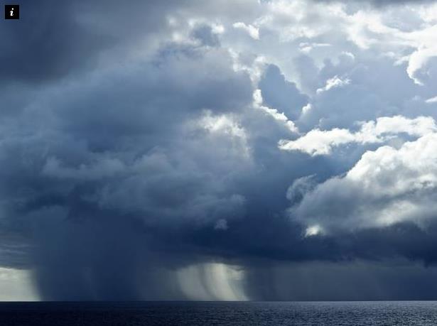
Scientists In Norway Left Completely Baffled By Freak Storm That Dumps 100mm of Rain In One Hour.
The Independent in the UK has the story; here's the intro: "
Scientists
in Norway have been left baffled by a storm at the edge of the Arctic
Circle that dumped more than 10cm of rain on a village in a single hour.
More than 100mm of rain fell on the Norwegian village of Ogndal,
an amount rarely seen outside the tropical rainforests of Brazil or
Indonesia. The downpour, which left farm animals petrified and
meteorologists scratching their heads, is believed to have shattered
records for the area, the Local has reported..."
Free Interactive Weather on the Web.
If you are mourning the demise of My-Cast on the web (it's still
available as an app!) there are other alternatives, including what we're
currently doing with
Aeris Weather.
Full disclosure: a previous company, Digital Cyclone, now owned by
Garmin, launched My-Cast, first on the web 15 years ago and then on
smart phones. Plug in your zip code into the Aeris link and you'll get a
variety of forecasts and maps, including an interactive capability that
has some powerful options. (note: try the full screen mode to get the
full effect and full resolution).
States Are Polluting Less And Their Economies Are Doing Just Fine.
Grist has the details; here's the introduction: "
Even
as America’s economy started to rebound from the recession between 2008
and 2013, climate change–causing power plant emissions in the majority
of American states did not, according to a new study. Earlier this year, environmentalists celebrated the news that, while the world’s economy continued to grow, CO2 emissions remained flat in 2014. This new report is the most thorough examination so far of how that trend is playing out in the U.S..."
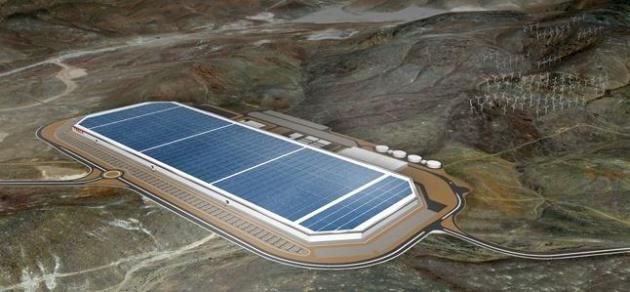
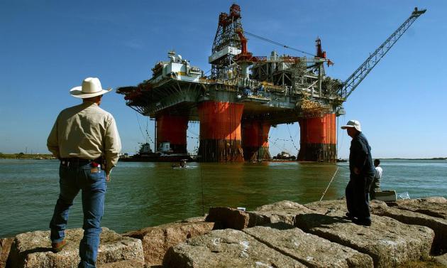
Does Elon Musk's Tesla Model S "Signal The Beginning Of The End For Oil?" EcoWatch has the story; here's a clip: "...
At
least that's the word on the street after Story County official Dean
Haymore revealed that the electric vehicle/battery maker initially
bought a thousand acres to start with, then recently swoooped up another
1,200 acres and another 350 acres on top of that. As Tech News Today
writes, Tesla "initially intended to purchase 10 million square-feet of
land for its Gigafactory, but after recent plans of acquisitions, it
seems Tesla will end up with more than 24 million square-feet of land,
making in the largest factory in the world..."
Image credit above: "
Tesla broke ground on its Gigafactory in June 2014 outside Sparks, Nevada." Photo credit: Tesla Motors.
Buffet Scores Cheapest Electricity Rate With Nevada Solar Farms.
Mr. Buffet has a pretty good track record when it comes to investing -
the fact that he is all-in with solar should be a signal to the rest of
us. Follow the (smart) money, right? Here's an excerpt from
Bloomberg Business: "
Warren
Buffett’s Nevada utility has lined up what may be the cheapest
electricity in the U.S., and it’s from a solar farm. Berkshire Hathaway
Inc.’s NV Energy agreed to pay 3.87 cents a kilowatt-hour for power from
a 100-megawatt project that First Solar Inc. is developing, according
to a filing
with regulators. That’s a bargain. Last year the utility was paying
13.77 cents a kilowatt-hour for renewable energy. The rapid decline is a
sign that solar energy is becoming a mainstream technology with fewer
perceived risks. It’s also related to the 70 percent plunge in the price
of panels since 2010, and the fact that the project will be built in
Nevada, the third-sunniest state..."
The Pluto "Truthers" Insist NASA Images Are Fake. Conpiracy theories: because real science and "thinking" is hard! Details from
Gizmodo: "
It wouldn’t be a monumental achievement in human history without some truthers on the internet calling it fake. And NASA’s historic Pluto flyby
is no different. The conspiracy theory crowd has descended on the event
as their too-good-to-be-true choice this week. Wake up sheeple! Pluto
is just a dog at Disneyland!..."
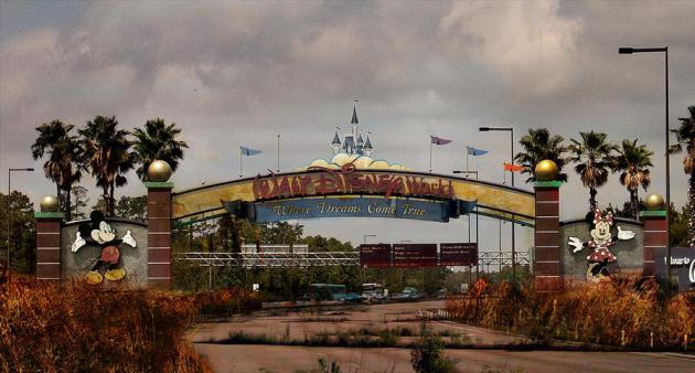
"Abandoned Disney World". Disney, after the apocalypse. This visual piece from
Huffington Post should cheer you up; here's the intro: "
It's a world of dread. It's a world of fear. It's a world where there isn't anybody there. DeviantArt user eledoremassis02 laid waste to some of Walt Disney World's iconic attractions for his project "Life After Disney,"
which he has been sharing on the art website since 2010. Decaying
boulevards, a smoldering Epcot Center and some extra-creepy animatronic
characters are just a few of the sights to behold on his virtual tour of
the post-apocalyptic theme park..."
Image credit above:
eledoremassis02 / Deviant Art. "
Main Entrance".
TODAY: Hazy sun, lake-worthy. Dew point: 67 Winds: SW 10. High: near 90 (heat index: low 90s)
FRIDAY NIGHT: Humid with T-storms late. Low: 71
SATURDAY: Sticky sun, few T-storms. Dew point: 72. High: 92 (heat index: mid to upper 90s)
SUNDAY: Plenty of sun, less humid. Dew point: 59. Wake-up: 68. High: 85
MONDAY: Sunny, plenty warm. Wake-up: 67. High: 88
TUESDAY: Bright sun, a bit more comfortable. Wake-up: 68. High: 85
WEDNESDAY: Murky sun, nighttime T-storms. Wake-up: 65. High: 83
THURSDAY: Damp start, then sticky sunshine. Wake-up: 66. High: 85
Climate Stories....
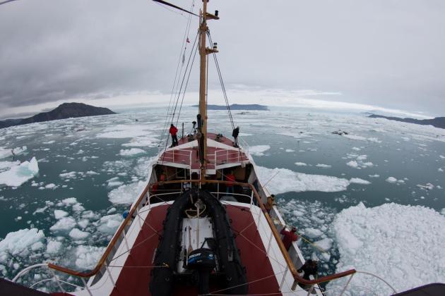
Greenland's Fjords Are Far Deeper Than Previously Thought, And Glaciers Will Melt Faster, Researchers Find. AGU (American Geophysical Union) Blogosphere has the story - here's the intro: "
West
Greenland’s fjords are vastly deeper than rudimentary models have
shown, allowing intruding ocean water to badly undercut glacier faces,
which will raise sea levels around the world much faster than previously
estimated. Those are the findings of a University of
California-Irvine-led research team that battled rough waters and an
onslaught of icebergs for three summers to map the remote channels for
the first time. The results have been accepted for publication
in Geophysical Research Letters, a journal of the American Geophysical
Union and are now available online..."
Photo credit above: "
University
of California-Irvine and JPL glaciologists aboard the Cape Race in
August 2014 mapped for the first time remote Greenland fjords and ice
melt that’s raising sea levels around the globe." Credit: Maria Stenzel.
Lindsey Graham: "Why Don't Republicans Believe The Scientists on Climate Change?"
I can answer that one: because they fear the cure will be worse than
the disease, that solving this problem will require massive new federal
subsidies, regulations; an EPA on steroids. Merely acknowleding the
elephant in the living room will require bigger government, more
government,which means less personal freedom. When, in fact, any
solutions will stimulate business, innovation and global
competitiveness, adding (clean energy) jobs while reducing the risk to
future generations. Here's an excerpt from
ThinkProgress: "
Well I’m not a scientist,” Graham responded, echoing the numerous lawmakers
who have plead ignorant to the mechanisms behind the earth’s weather
and climate when asked if they think climate change is happening. “I
know I’m not a scientist,” he continued, “but here’s the problem I’ve
got with some people in my party: When you ask the scientists what’s
going on, why don’t you believe them? If I went to 10 doctors and nine
said, ‘Hey, you’re gonna die,’ and one says ‘You’re fine,’ why would I
believe the one guy?...”
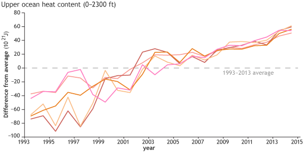
NOAA State Of The Climate Report: Which Seven Records Were Broken in 2014? One of many records was ocean heat content according to a summary at
Carbon Brief; here's an excerpt: "...
It
wasn't just the surface of the oceans that had a warm year, the report
finds. Measurements over the top 700m of the ocean show that 2014 was
also a record year for the amount of heat stored in the ocean.
This reflects the continued increase of energy in the oceans, which
absorb over 90% of the heat trapped in the atmosphere by greenhouse
gases, the report says..."
Image credit above: "Ocean heat content each year since 1993 compared to the 1993-2013 average (dashed line) from a variety of data sources." Graph adapted from Figure 3.7 in
State of the Climate in 2014
ExxonMobil Gave Millions To Climate-Denying Lawmakers Despite Pledge. My
late father in law was a prolific PhD chemist for Exxon with a long
list of patents. Part of me is glad he's not around to see this. Here's
an excerpt from
The Guardian: "
ExxonMobil
gave more than $2.3m to members of Congress and a corporate lobbying
group that deny climate change and block efforts to fight climate change
– eight years after pledging to stop its funding of climate denial, the
Guardian has learned. Climate denial – from Republicans
in Congress and lobby groups operating at the state level – is seen as a
major obstacle to US and global efforts to fight climate change,
closing off the possibility of federal and state regulations cutting
greenhouse gas emissions and the ability to plan for a future of
sea-level rise and extreme weather..."
Photo credit above: "
ExxonMobil pledged in 2007 to stop funding climate denial." Photograph: Michelle Christenson/AP.
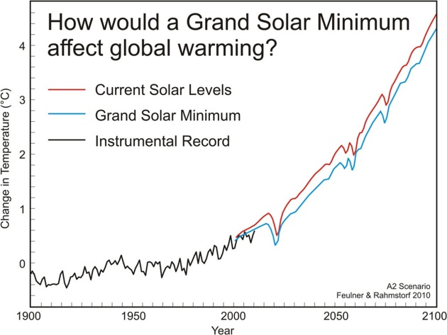
No, The Sun Isn't Going To Save Us From Global Warming.
The Guardian has the explanation - here's an excerpt: "
Some zombie myths just won’t die. In fact, I debunked this one two years ago right here at The Guardian.
To sum up, a number of scientific studies have asked the question, ‘if
the sun were to enter another extended quiet phase (a grand solar
minimum), how would that impact global surface temperatures?’. Every
study agrees, it would cause no more than 0.3°C cooling, which would
only be enough to temporarily offset about a decade’s worth of
human-caused global warming..."
Image credit above: "
The
global mean temperature difference is shown for the time period 1900 to
2100 for the IPCC A2 emissions scenario. The red line shows predicted
temperature change for the current level of solar activity, the blue
line shows predicted temperature change for solar activity at the much
lower level of the Maunder Minimum, and the black line shows observed
temperatures through 2010." Adapted from Feulner & Rahmstorf (2010) by SkepticalScience.com.
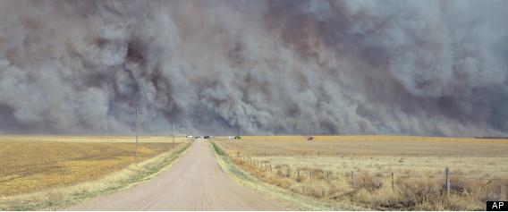
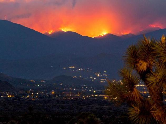
Scientists Say The Planet's Weather Is Becoming More Conducive to Wildfires. Chris Mooney has the story at
The Washington Post; here's a clip: "...
“Climate is a well-known driver of wildfire behavior,” notes a recent study of the factors behind increased expenditures on combating wildfires in the west. But the new research
— published Tuesday in Nature Communications, and dubbed a work of
“global pyrogeography” by its authors — shows that a changing climate
is indeed likely altering wildfires, and doing so on a global scale. The
study finds that the seasons of the year featuring fire-friendly
conditions – so-called “fire weather” – are lengthening, and moreover,
that this has been happening on every continent that features wildfires
except for Australia..." (File photo: AP).
Across The Globe, Wildfire Season Is Lasting Longer. ThinkProgress has the story, following up on the research referenced above; here's an excerpt: "...
Over
the last several decades, the report notes, the United States has seen a
particularly marked increase in the frequency and duration of large
wildfires, especially in the Northern Rocky Mountains. The report links
this increase to earlier snowmelt, which creates drier conditions
earlier in the summer. In general, the report found, areas with the
greatest changes in local weather are the most likely to see changes in
their wildfire season: Our results extend these findings by
demonstrating that areas with the most significant change in fire
weather season length occur where not only temperature but also changes
in humidity, length of rain-free intervals and wind speeds are most
pronounced..." (File photo: NOAA).
Scientists Warn Geo-Engineering Is Not The Answer To Climate Change. That's like saying - I can just take a pill if I gain too much weight. Right. Here's a snippet from
businessgreen.com: "
Climate-engineering
techniques such as recapturing carbon dioxide from the atmosphere and
reflecting solar radiation will not help tackle climate change in the
short term, research finds. A new EU-wide analysis
- published yesterday by a group of 14 academic institutions including
the Universities of Cambridge, Exeter, Bristol and East Anglia -
concludes so-called geo-engineering interventions are not a substitute
for reductions in carbon emissions..."
The Weather.com Climate Disruption Index. A
number of esteemed climate scientists who I respect weighed in on this
project, ranking the U.S. cities most vulnerable to climate volatility.
Minneapolis came in second, behind New Orleans, and St. Paul weighed in
at number 8. There's little doubt we're already being impacted by
greater swings in drought and flood, more whiplash as ecosystems
transition slowly northward with rising temperatures and warming
winters, but I can understand why a difference of 12 miles would make a
difference between number 2 and number 8 on the list. That's a
head-scratcher. Here's an excerpt at
weather.com: "
Minneapolis
could get pummeled from a lot of different angles, making it number 2
on our list. The city itself will be a good deal hotter than rural
places close by. It has seen precipitation increase by almost 40 percent
since 1958, a trend expected to continue. Drought here will also
continue to worsen. The city isn’t waiting around for these changes; in
2013, it implemented a sustainability plan
that includes reducing energy consumption by 17 percent and using
renewable forms of energy to meet 10 percent of its needs by 2025..."
Wildfires Are Happening More Often And In More Place. According to new research highlighted at
Smithsonian average fire season length has increased by a fifth, and the area impacted has doubled. Here's an excerpt: "...
In
places where wildfires most commonly occur, fire danger indices have
been developed that use local weather variables to predict the risk that
a fire will spark and spread. Matt Jolly, an ecologist with the U.S.
Forest Service, and his colleagues combined several of these indices
with surface weather data to explore how fire seasons have changed over
the last 35 years. Globall, average fire season length increased by 18.7
percent, the researchers report today in Nature Communications..."
Photo credit above: "
Flames and smoke cover the hillsides near Yucca Valley in California during a June wildfire." (NPS/Brad Sutton).
How Climate Change Could Affect Your Finances.
US News has the story - here's a snippet: "...
So you could have trouble selling your house
and perhaps keeping your job. And while that sounds like an alarmist
conclusion, and it may well be, a recent report released by the
Environmental Protection Agency called, "Climate Change in the U.S.:
Benefits of Global Action," concluded that by the end of the century,
the U.S. could experience up to $180 billion in economic losses due to
drought and water shortages. Homeowners insurance
will rise. In June, a study published in the U.K. journal Nature
Climate Change concluded that man-made global warming is responsible for
about 75 percent of all hot-temperature extremes worldwide over the
past 100 years as well as 18 percent of heavy rainfall..."


No comments:
Post a Comment