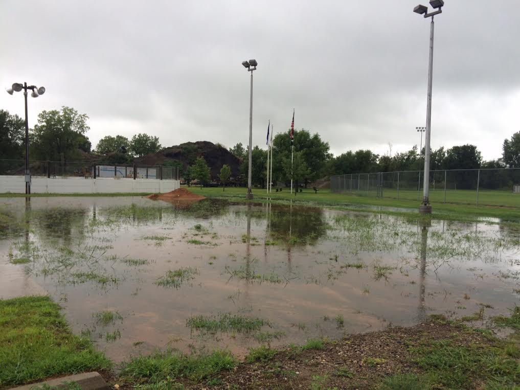
We haven't had a day like Tuesday in quite a while. Steady rain, heavy at times, led to numerous puddles and slow commutes. Rain will continue on Wednesday, but it won't be as heavy. Hang in there... Sunshine and mild temperatures return by the end of the week.
"Aug-tober"
By Paul Douglas
If the vast majority of the world's scientists are right we can expect more head-scratching weather moments going forward. Extremes that make us step back and do a triple-take.
A "Black Swan" is defined as: "an unpredictable or unforeseen event, typically one with extreme consequences.
"Like a hurricane merging with a nor'easter and turning northwest toward land in late October (Sandy in 2012), 10-inch rains in Duluth, Minnesota (2012), MSP rains in January, or heat waves and droughts that are longer and much more severe than the norm (Russia in 2010, California from 2011-2015). More 2-4 sigma events; up to 4 times the standard deviation.
Yesterday's drenching rain and mid 60s was typical for October 2. Maybe not a true Black Swan, but more evidence of a new level of volatility in the system. I'm still optimistic the markets will come up with the solutions we're going to need to adapt, and thrive.
Showers taper today as winds gust to 30 mph. Warm sun returns as highs surge into the 80s Friday and Saturday before weekend thunder and another freakishly cool push early next week.
The GFS model brings 90s into town the last few days of August. A wild ride - hang on tight!
________________________
TUESDAY NIGHT: Spotty showers . Low: 58. Winds: Turning SSW 10-15.
WEDNESDAY: Feels like fall. Breezy and cooler with lingering showers. High: 64. Winds: WNW 15-30
WENESDAY NIGHT: Breezy with lingering showers. Low: 54. Winds: WNW 15-30
THURSDAY: Sunny and drier. Not as windy. Wake-up: 54. High: 78
FRIDAY:Warm sun, feels like August again. Wake-up: 61. High: 83.
SATURDAY: Sticky sun, strong T-storms late. Wake-up: 65. High: 84
SUNDAY: Gusty and cooler, few showers. Wake-up: 62. High: 67.
MONDAY: More clouds than sun, Septemberish. Wake-up: 55. High: 66.
TUESDAY: Roller coaster continues, mild sun. Wake-up: 58. High: 76
__________________________
This Day in Weather History
August 19th
2007: Record 24-hour maximum rainfall of 15.10 inches set in Hokah, MN (Houston County). This 24-hour total contributed to the record monthly maximum rainfall of 23.86 inches that was set in Hokah during August of 2007.
1980: Strong winds at Belle Plaine severely damage five planes.
___________________________
Average High/Low for Minneapolis
August 19th
Average High: 80F (Record: 97F set in 1976)
Average Low: 62F (Record: 39F set in 1967)
____________________________
Sunrise/Sunset Times for Minneapolis
August 19th
Sunrise: 6:19am
Sunset 8:13pm
*Daylight lost since yesterday: 2 minutes & 50 seconds
*Daylight lost sin summer solstice (June 21): ~1 hour & 43 minutes
______________________________
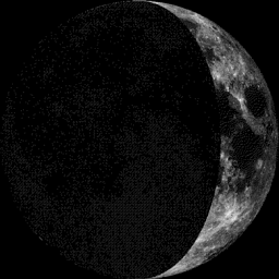
Moon Phase for August 19th at Midnight
2.5 Day Before First Quarter
____________________________________
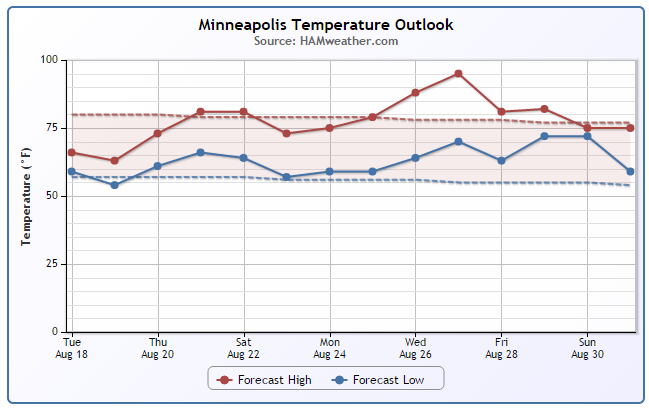
Minneapolis Temperature Trend
Temperatures on Tuesday and Wednesday, more reminiscent of late September and early October will give way to near average reading again by the end of the week/weekend ahead. Interestingly, extended forecasts are suggesting a pretty big surge in the temperature department by day 1 of the MN State Fair... perfect timing, right? It's still a bit too early to believe it, but it's something to keep an eye on.
_____________________________________
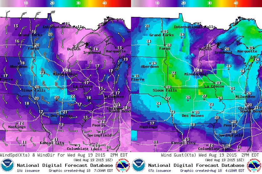
Wednesday Weather Outlook
The vigorous low pressure system moving through the Upper Midwest will still play a part in our weather on Wednesday. Highs in the upper 50s and low/mid 60s will be more reminiscent of early October rather than mid August. Rain and gusty winds will make for another fairly raw day...
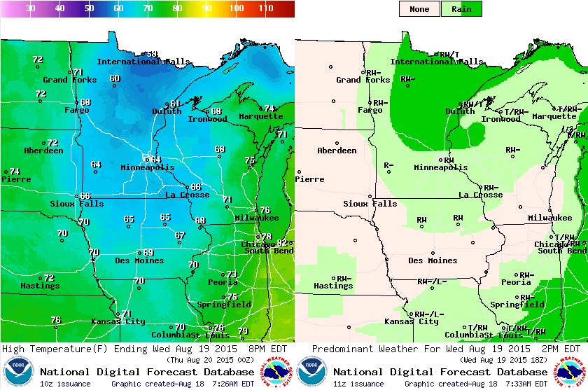
Wednesday Weather Outlook
Winds surrounding the area of low pressure will be quite impressive on Wednesday. Sustained winds across western and southern MN will be in the 20mph range with wind gusts approaching 30mph+!
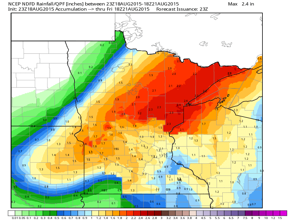
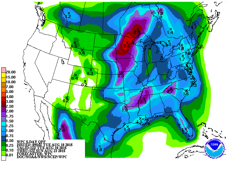
Rainfall Potential
Rainfall potential from PM Tuesday to Friday suggests heavier rain still possible across parts of NE Minnesota as the storm system lifts into Canada.
____________________________________
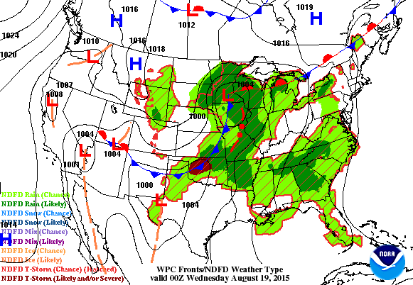
National Weather Outlook
Our fall-like storm system will begin to loosen it's grip (a little) across parts of the mid-section of the nation on Wednesday, but it'll be more noticeable on Thursday as the center of the storm lifts north toward the Hudson Bay. Ongoing showers and thunderstorms will push along and east of the Appalachians. Meanwhile, note how quite it looks across much of the rest of the nation on Thursday!
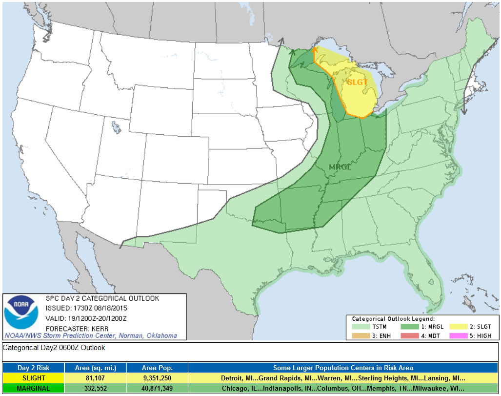
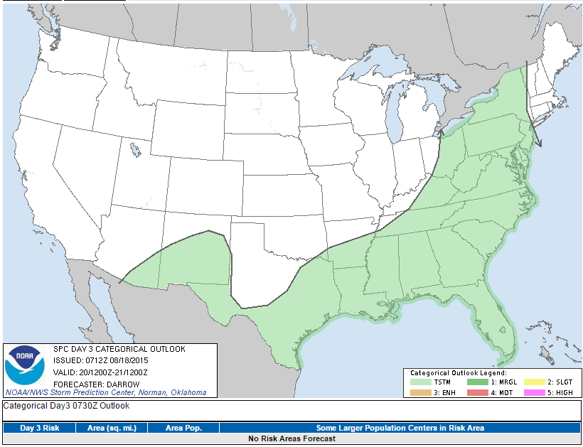
Severe Threat Wednesday
...SUMMARY... SCATTERED STRONG TO SEVERE STORM DEVELOPMENT IS POSSIBLE WEDNESDAY INTO WEDNESDAY NIGHT ACROSS PARTS OF THE GREAT LAKES REGION...LOWER OHIO VALLEY AND OZARK PLATEAU. ...SYNOPSIS... AMPLIFIED MID/UPPER TROUGHING WITHIN THE SOUTHERN BRANCH OF SPLIT MID-LATITUDE WESTERLIES APPEARS LIKELY TO CONTINUE TO SUPPORT FAIRLY SIGNIFICANT LOW/MID-LEVEL CYCLOGENESIS FROM PORTIONS OF THE MID MISSOURI VALLEY INTO THE UPPER MISSISSIPPI VALLEY LATER TODAY AND TONIGHT. THE SURFACE LOW CENTER MAY REACH THE MINNEAPOLIS MN VICINITY BY 12Z WEDNESDAY...WHILE BEGINNING TO OCCLUDE...BEFORE MIGRATING SLOWLY NORTH NORTHEASTWARD INTO THE UPPER GREAT LAKES REGION THROUGH THE REMAINDER OF THE PERIOD. THE TRAILING COLD FRONT...LIKELY CURVING ACROSS THE MIDDLE MISSISSIPPI VALLEY INTO THE SOUTH CENTRAL PLAINS BY DAYBREAK WEDNESDAY...IS GENERALLY FORECAST TO ADVANCE AS FAR EAST AND SOUTH AS THE LOWER GREAT LAKES REGION...MIDDLE OHIO AND LOWER MISSISSIPPI VALLEYS...AND SOUTHERN PLAINS BY 12Z THURSDAY. SEASONABLY MOIST CONDITIONS WILL PERSIST ALONG/AHEAD OF THE FRONT. HOWEVER...IT APPEARS THAT BOUNDARY LAYER DESTABILIZATION WILL CONTINUE TO BE HINDERED BY THE LINGERING PRESENCE OF RELATIVELY WARM AIR ALOFT. MODELS REMAIN SUGGESTIVE THAT THE MID-LEVEL COLD POOL ASSOCIATED WITH THE UPPER TROUGH WILL CONTINUE TO LAG TO THE WEST OF THE COLD FRONT...EVEN AS THE UPPER TROUGH TAKES ON AN INCREASINGLY NEGATIVE TILT ACROSS THE UPPER MIDWEST/GREAT LAKES/LOWER OHIO VALLEY REGION DURING THE LATTER HALF OF THE PERIOD. SOUTH OF THE GREAT LAKES REGION...CONSIDERABLE MID/HIGH-LEVEL CLOUD COVER...AND PERHAPS AN EARLY DAY START TO FRONTAL/PRE-FRONTAL CONVECTIVE DEVELOPMENT...MAY HAMPER SURFACE HEATING. FURTHERMORE...IT APPEARS THAT PRE-FRONTAL SOUTH/SOUTHWESTERLY LOWER/MID TROPOSPHERIC WIND FIELDS WILL BE RATHER MODEST IN STRENGTH...ON THE ORDER OF 20-30+ KTS OR SO.
Severe Threat Thursday
...SUMMARY... SCATTERED THUNDERSTORMS ARE EXPECTED TO DEVELOP AHEAD OF A FRONTAL BOUNDARY FROM UPSTATE NEW YORK...SOUTHWEST ACROSS THE GULF COAST STATES TO DEEP SOUTH TEXAS. OTHER STORMS ARE EXPECTED OVER THE SOUTHERN ROCKIES. ...SYNOPSIS... PRONOUNCED TROUGH WILL EJECT NEWD ACROSS THE GREAT LAKES THROUGH ONTARIO INTO WRN QUEBEC BY THE END OF THE PERIOD WHICH WILL FORCE A COLD FRONT INTO THE OH VALLEY BY 18Z...EXTENDING SWWD INTO CNTRL TX. WHILE LARGE-SCALE FORCING WILL GLANCE THE UPPER OH VALLEY INTO UPSTATE NY...MEAGER FORCING WILL BE NOTED ALONG THE TRAILING WIND SHIFT SOUTH OF THE OH RIVER. SCATTERED CONVECTION WILL LIKELY BE ONGOING AT THE BEGINNING OF THE PERIOD ALONG THE FRONTAL ZONE AND CLOUDS/PRECIPITATION SHOULD INHIBIT DIABATIC HEATING ALONG THIS CORRIDOR. LATEST FORECAST SOUNDINGS SUGGEST WEAK LAPSE RATES WILL BE NOTED WITHIN A PLUME OF HIGH PW VALUES...1.75-2 INCHES...THAT WILL EXTEND FROM SOUTH TX...NEWD INTO WRN NY. POOR LAPSE RATES AND WEAK-MODEST INSTABILITY SHOULD LIMIT SEVERE THREAT WITH STORMS THAT EVOLVE ALONG THE ADVANCING COLD FRONT. EVEN SO...A FEW ROBUST TSTMS COULD GENERATE MARGINALLY SEVERE WIND GUSTS BUT COVERAGE DOES NOT APPEAR SUFFICIENT TO WARRANT SEVERE PROBS THIS PERIOD. FARTHER SW...ISOLATED THUNDERSTORMS MAY ALSO DEVELOP ACROSS PORTIONS OF THE SRN ROCKIES WHERE STRONG HEATING IS EXPECTED ALONG WRN FRINGE OF STALLED FRONTAL ZONE.
5 Day Precipitation Outlook
Soaking rains fell across parts of the Midwest over the last couple of days, but it appears that weather conditions will start to dry rapidly after Wednesday. The heaviest precipitation through the end of the week looks to move east of the Mississippi Valley. Unfortunately, dry weather looks to persist across much of the Western U.S., where incredible drought and massive wildfires continue.
_____________________________________
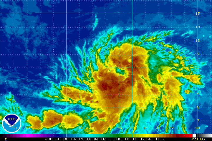
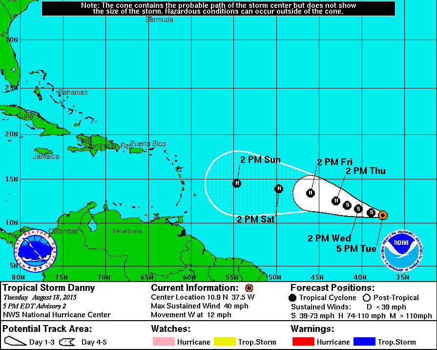
Hello Danny!
As of Tuesday afternoon (CDT) the National Hurricane Center starting issuing advisories on Tropical Storm Danny in the central Atlantic. The loop below showed T.S. Danny by Tuesday afternoon, note that it appears to have a fairly broad area of circulation, which indicates a fairly decent amount of organization.
Tracking Danny
Here's the latest from the NHC:
DISCUSSION AND 48-HOUR OUTLOOK
At 500 PM AST (2100 UTC), the center of Tropical Storm Danny was located near latitude 10.9 North, longitude 37.5 West. Danny is moving toward the west near 12 mph (19 km/h). Danny is expected to turn west-northwest on Wednesday. Maximum sustained winds increased to near 40 mph (65 km/h) on Tuesday afternoon with higher gusts. Additional strengthening is forecast during the next 48 hours, and Danny is expected to become a hurricane by Thursday.
 ______________________________
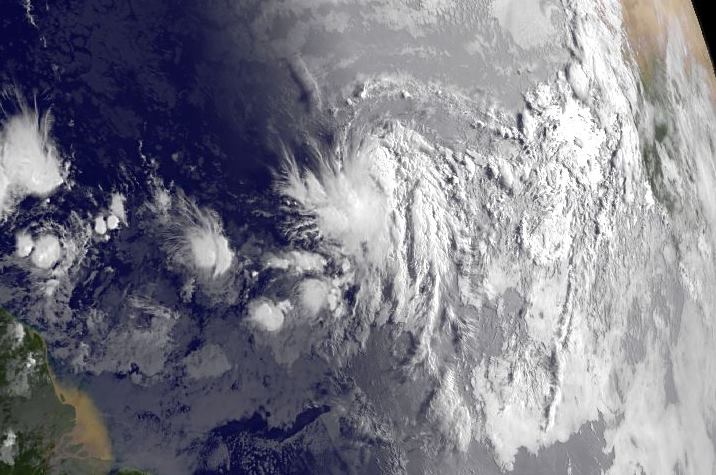
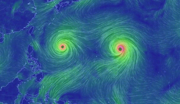
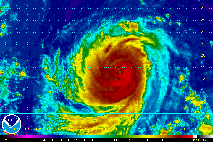
Pacific Problems
"Eye" can see you! The circulations in association with Typhoon GONI and ATSONI are pretty impressive... they actually look like eyes, don't they?
Tracking Typhoons
According to the Joint Typhoon Warning Center, Typhoon GONI is the storm to watch as the forecast track takes it close to Taiwan by the end of the week/weekend. Keep in mind that Typhoon SOUDELOR slammed the island a couple of weekends ago with significant impacts. Typhoon ATSANI on the other hand looks to track more northwesterly, but could potentially become a Super Typhoon at some point Wednesday with sustained winds near 160mph! YIKES!!
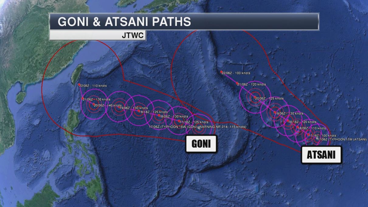
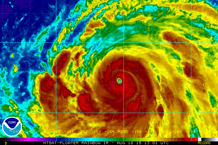
Typhoon ATSANI
According the Joint Typhoon Warning Center, Typhoon ATSANI was a equivalent to a category 4 hurricane with sustained winds near 140mph on Tuesday evening (CDT).
Typhoon GONI
According to the Joint Typhoon Warning Center, Typhoon GONI was equivalent to a category 3 hurricane with sustained winds near 115mph on Tuesday evening (CDT).
Thanks for checking in and have a great rest of your week. Don't forget to follow me on Twitter @TNelsonWX

No comments:
Post a Comment