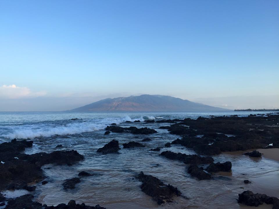
Thanks to my family members Aaron McEachran and Jessican Gust for the picture below from the Hawaiian Islands! Looks like you're enjoying your time!
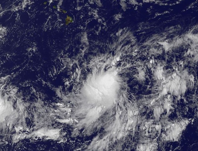
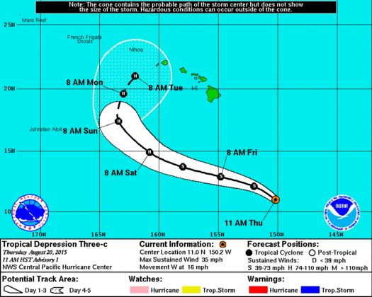
Tropical Depression 3 in the Central Pacific
Tropical Depression 3 is a new tropical system in the Central Pacific that may have some impacts on the small islands of Hawaii by the early/middle part of next week. The forecast calls for hurricane strength possible by this weekend... stay tuned!
"NOAA's Central Pacific Hurricane Center in Honolulu is issuing advisories on newly formed Tropical Depression Three-C. It's the sixth tropical cyclone in the central North Pacific basin this year. The depression is centered about 685 miles south-southeast of Hilo, with maximum sustained winds of 35 mph. Steady strengthening is forecast and the system may become a hurricane within 48 hours. A USAF Reserve hurricane hunter aircraft is scheduled to investigate the system on Friday evening, local time".
I Can't Bear It!
Here's a cute vine video from the U.S. Department of the Interior @Interior at Katmai National Park @KatmaiNPS in Alaska. They tweeted this video earlier this week saying that "This bear is clearly done with today #bearcam". I guess I can relate sometimes... HA!

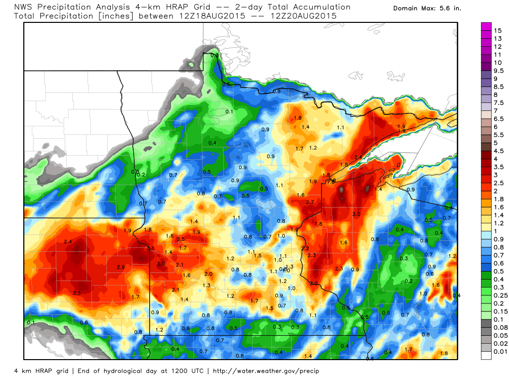
2 Day Rainfall
The image below suggests the radar estimated rainfall from AM Tuesday to AM Thursday, which shows a fairly decent 1" to near 3" spread across much of the area.
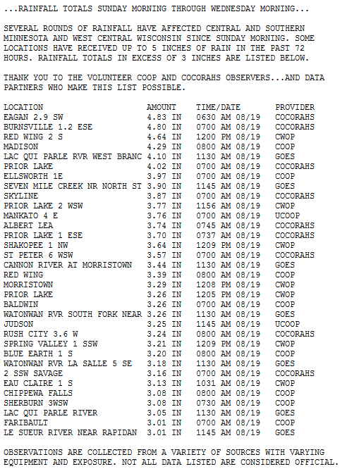
Heavy Rainfall Reports
Take a look at some of the heavy rain reports that were tallied across the state from Sunday to AM Wednesday.
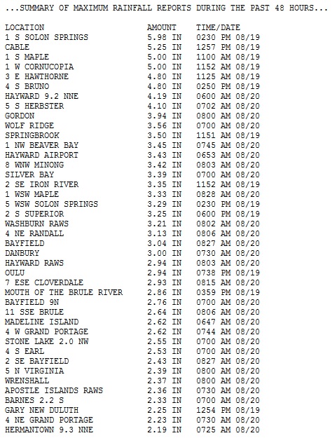
Here's another list from the National Weather Service out of Duluth of rainfall tallies from AM Tuesday to AM Thursday!
________________________________
A Slippery 7-Day
By Paul Douglas
"The trouble with weather forecasting is that it's right too often for us to ignore it and wrong too often for us to rely on it" mused Patrick Young. Yep. "Paul, you bubble-headed weather freak, why does the weekend forecast keep changing?" I get this a lot and it's a fair question.
For anything beyond 24 hours meteorologists rely on computer models. Current data from satellites, airports and a myriad of other sources goes into these models. The most common models (NAM, GFS, ECMWF) update 2-4 times a day; the HRRR updates hourly. To be able to forecast the weather we have to know what is happening now, worldwide. This "initialization" changes as new data arrives to power the models. Imagine fuel in an engine; but the octane shifts slightly every time you fuel up. Frustrating? You 'betcha. No, it's not a perfect science, like economics, the stock market or foreign policy.
Speaking of continuity, the GFS continues to pull a few 90s back into town just in time for the Minnesota State Fair. Surprised? Me neither.
Meanwhile it's back to the 80s today & Saturday. Watch for strong storms late Saturday, a puff of cooler air Sunday, then mild & quiet next week. That sounds good.
________________________________
THURSDAY NIGHT: Mostly clear and quiet. Low: 58. Winds: Turning SSE 5mph.
FRIDAY:Warm sun, feels like August again. High: 82. Winds: S 10-15mph
FRIDAY NIGHT: Mostly clear, a little warmer. Low: 66. Winds: S 10-15mph
SATURDAY: Breezy. Sunny start, late PM t-storms. High: 83 Winds: S 15-25mph
SUNDAY: Showers north, windy and cooler. Wake-up: 59. High: 71.
MONDAY: Bright sun, winds ease. Wake-up: 55. High: 74.
TUESDAY: Blue sky, just about perfect. Wake-up: 56. High: 79
WEDNESDAY: Parly sunny, warming up again. Wake-up: 60. High: 82.
THURSDAY: Sticky sun, a few t-storms flare up. Wake-up: 63. High: 83.
____________________________
This Day in Weather History
August 21st
1918: 3rd Deadliest tornado strikes Tyler and destroys the downtown area, leaving 36 dead.
1886: High winds hit Northfield with winds blowing at 60 mph for 20 minutes. The peak gusts were from 75 to 80 mph.
1883: 4th deadliest tornado in Minnesota history hits Rochester. The tornado killed 31 residents and inured 100 more. Appalled by the lack of medical care received by the tornado's victims, Mother Alfred Moes, founder of the Sisters of St. Francis, proposes to build and staff a hospital if Dr. W.W. Mayo will provide medical care. St. Marys Hospital opens in 1889 with 27 beds and eventually grows into the Mayo Clinic.
______________________________
Average High/Low for Minneapolis
August 21st
Average High: 80F (Record: 98F set in 1947)
Average Low: 61F (Record: 44F set in 2004)
_______________________________
Sunrise/Sunset Times for Minneapolis
August 21st
Sunrise: 6:22am
Sunset: 8:09pm
*Daylight lost since yesterday: ~2 minutes, 52 seconds
*Daylight lost since summer solstice (June 21st): ~1 hour, 48 minutes
_______________________________
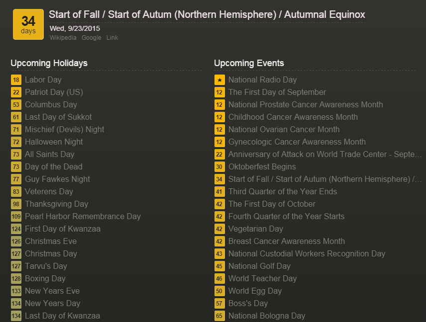
Autumnal Equinox 2015 - Wednesday, September 23rd at 3:22am CDT
I am not trying to hurry summer along by any means, but just a heads up; we are a little more than 1 month from the Autumnal Equinox! This year, the sun's most direct rays will pass over the Equator on Wednesday, September 23rd at 3:22am CDT, marking the first day of astronomical fall in the northern hemisphere.
Here's a list of how many days left until certain days of interest... note that we are 34 days from Fall and 127 days from Christmas Day... via xdaysleft.com
__________________________________
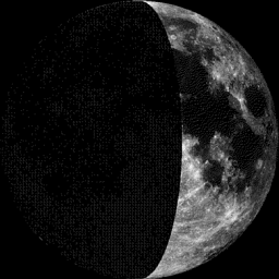
Moon Phase for August 21st at Midnight
0.5 Days Before First Quarter
____________________________________
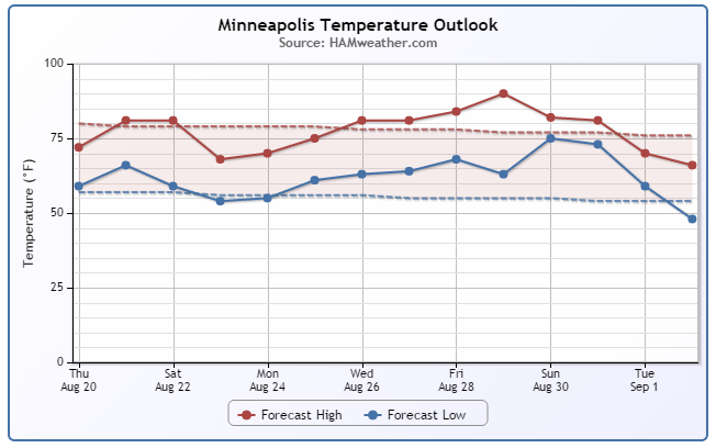
Minneapolis Temperature Trend
August-like temperatures return Friday and Saturday with an increase in dewpoints. It'll feel a little more muggy on Saturday ahead another fairly vigorous storm system that may kick out a few strong/severe storms late in the day. Note the puff of September-like air that funnels in behind it through early next week. We're still tracking a decent warm spell late next week/weekend just in time for the start of the MN State Fair. We are starting to get closer to that time of year when big temperature swings take place ahead of and behind storm systems that develop more frequently due to cold air building up north.
_________________________________
Friday Weather Outlook
Highs on Friday will climb back into 80s across much of the state with the exception along the North Shore and extreme northern Minnesota. Dewpoints will also climb into 60s, so it'll feel more sticky than it did earlier this week.
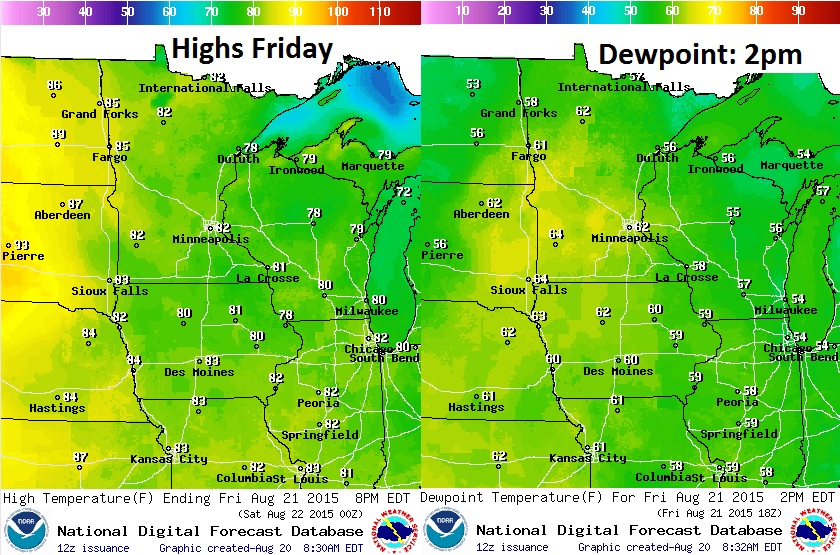
Friday Weather Outlook
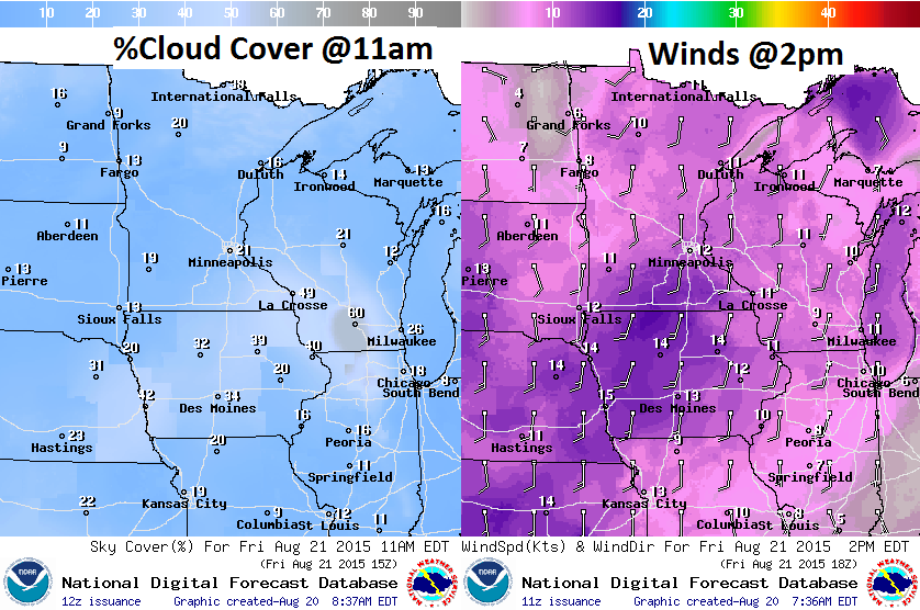
We'll have a few more clouds across the region on Friday, especially across
__________________________________
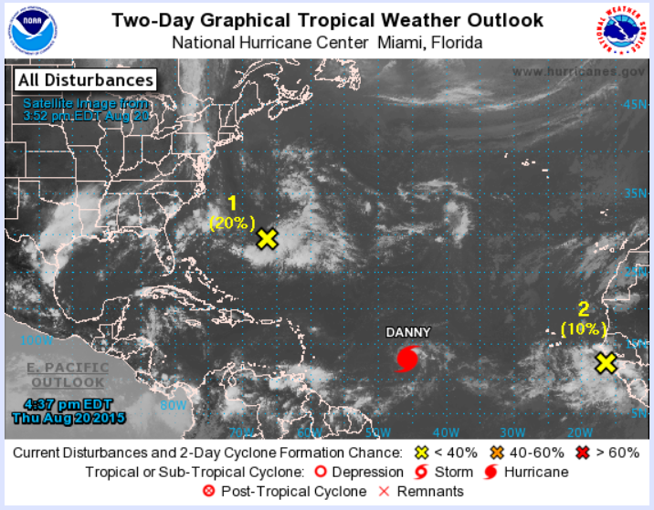
Action in the Atlantic
The National Hurricane Center has recently added a couple areas of interest on their watch list. As of Thursday, Danny was still a tropical storm, but notice the slight chances of development on a wave just of the East Coast and another one moving off the West Coast of Africa... it looks like things are starting to heat up in the Atlantic basin a little bit!
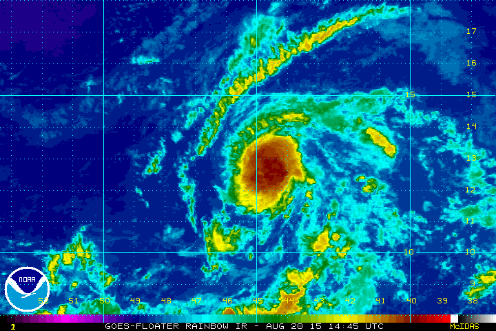
Danny in the Atlantic
"Hurricane Danny strengthened a little more Thursday afternoon. with sustained winds near 80 mph - a Category 1 hurricane on the Saffir-Simpson Hurricane Wind Scale. Some additional strengthening during the next 24 hours was forecast, but a weakening trend was expected to begin after that. Danny was centered over the central tropical Atlantic Ocean about 1030 miles east of the Windward Islands, moving toward the west-northwest near 10 mph. This general motion is expected to continue into Saturday. There are no coastal watches or warnings in effect. Both NOAA and Air Force Reserve Unit reconnaissance aircraft will be investigating Danny Friday afternoon, and that data will provide a better estimate of the hurricane's structure and strength."
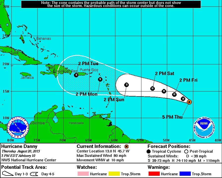
Tracking Danny
According to NOAA's NHC, Danny will continue tracking west toward the Caribbean over the next several days with some intensification. However, upper level winds are stronger in the Caribbean, so this may help to weaken Danny into a tropical storm by early next week. Stay tuned.
_______________________________
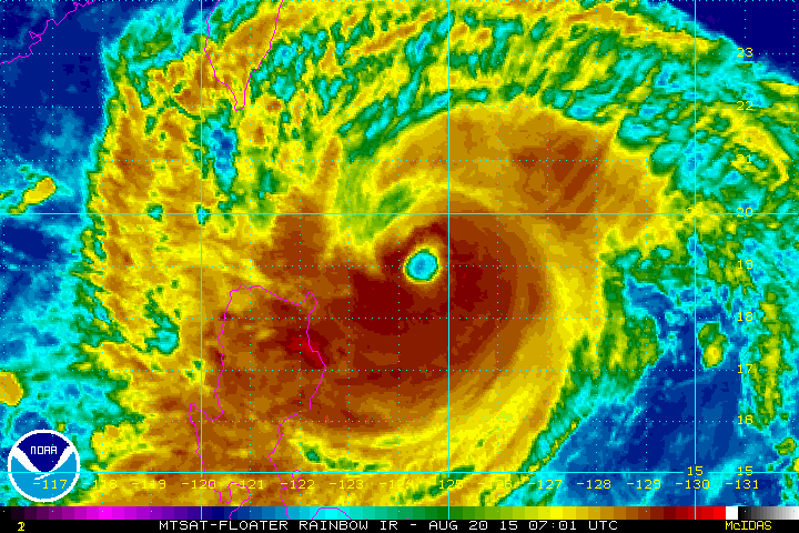
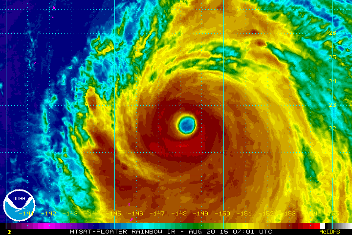
Dual Typhoons in the Pacific
Incredible image from the Himawari-8 satellite of GONI and ATSANI, 2 very strong typhoons currently ongoing in the West Pacific... So beautiful, yet so violent!
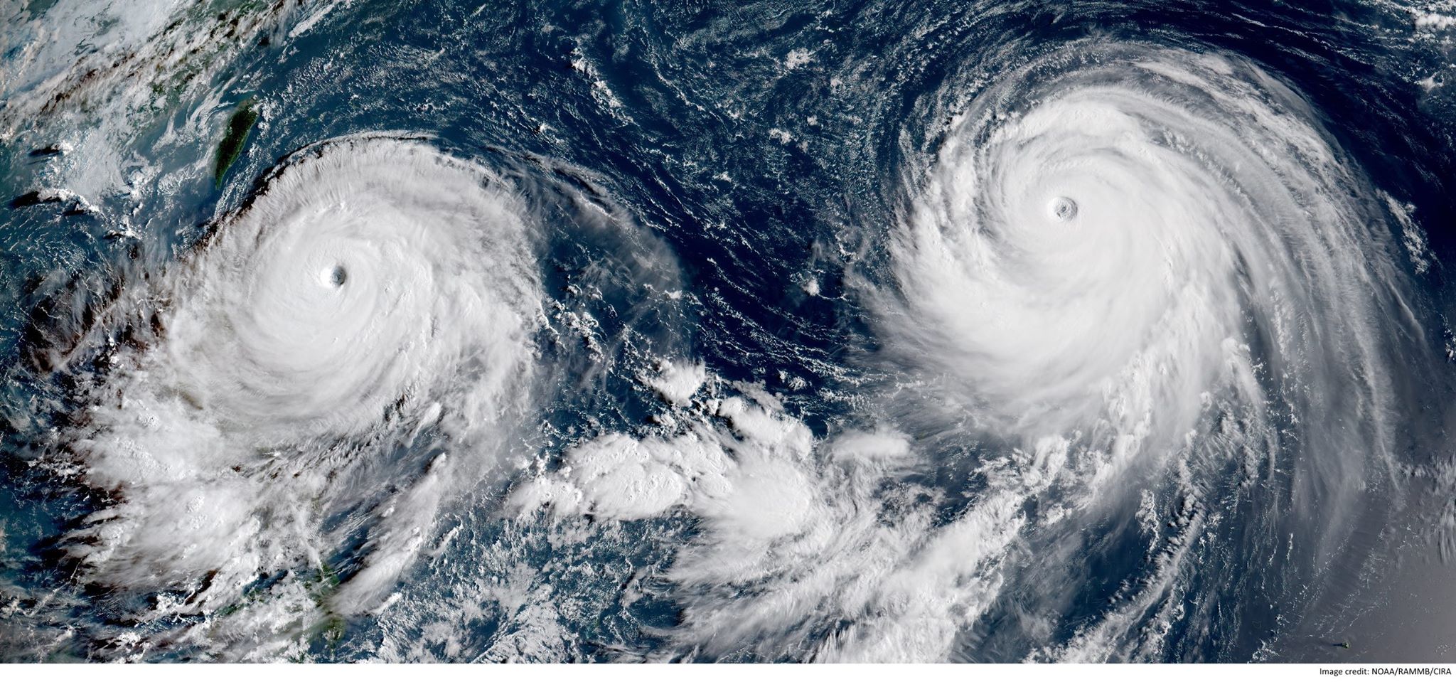
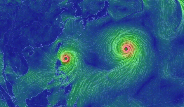
Typhoon GONI
Typhoon ATSANI
________________________________
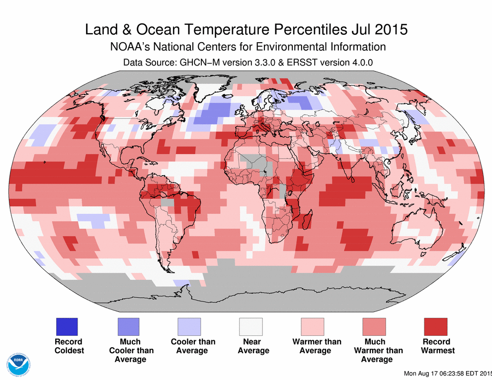
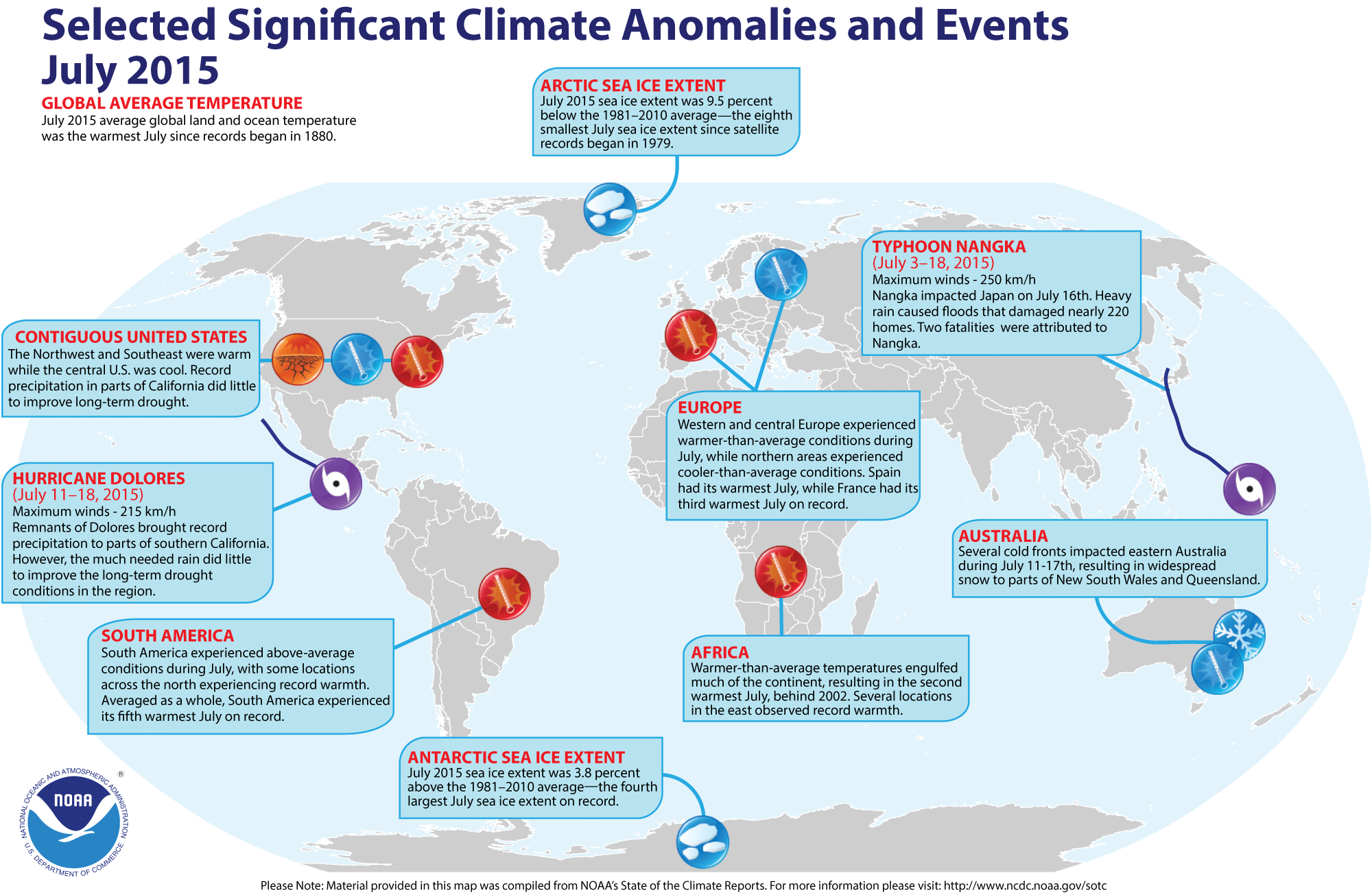
July 2015 was Warmest Month EVER Recorded for the Globe !!
NOAA recently released stats for the month and found that July 2015 was the warmest month EVER recorded for the globe!! Also, global oceans were at record warmth for July and January-July 2015 was also the warmest on record. Here are some stats from NOAA for the month of the July:
- The July average temperature across global land and ocean surfaces was 1.46°F (0.81°C) above the 20th century average. As July is climatologically the warmest month for the year, this was also the all-time highest monthly temperature in the 1880–2015 record, at 61.86°F (16.61°C), surpassing the previous record set last year in 2014 by 0.14°F (0.08°C).
- Separately, the July globally-averaged land surface temperature was 1.73°F (0.96°C) above the 20th century average. This was the sixth highest for July in the 1880–2015 record.
- The July globally-averaged sea surface temperature was 1.35°F (0.75°C) above the 20th century average. This was the highest temperature for any month in the 1880–2015 record, surpassing the previous record set in July 2014 by 0.13°F (0.07°C). The global value was driven by record warmth across large expanses of the Pacific and Indian Oceans.
- The average Arctic sea ice extent for July was 350,000 square miles (9.5 percent) below the 1981–2010 average. This was the eighth smallest July extent since records began in 1979 and largest since 2009, according to analysis by the National Snow and Ice Data Center using data from NOAA and NASA.
Antarctic sea ice during July was 240,000 square miles (3.8 percent) above the 1981–2010 average. This was the fourth largest July Antarctic sea ice extent on record and 140,000 square miles smaller than the record-large July extent of 2014.
See more from NOAA HERE:
Selected Significant Climate Anomalies and Events - July 2015
_________________________________
Thanks for checking in and have a great end of the week/weekend ahead! Don't forget to follow me on Twitter @TNelsonWX

No comments:
Post a Comment