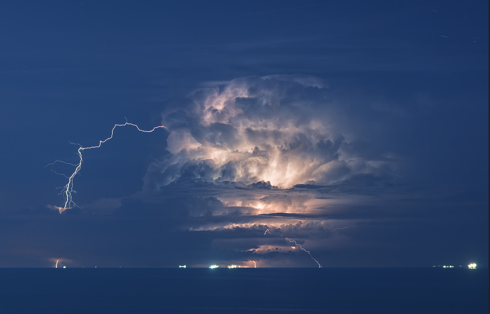
WOW! What an incredible picture... Niccolo Ubalducci, A friend of mine from Gabicce, Italy, snapped this picture Thursday in Italy! Turns out, Niccolo and I began friends over social media because of our love of weather. A few years ago, I did a live Skype interview with Niccolo on DirectTV (WeatherNation TV) and talked about a snow storm that crippled parts of his hometown... pretty wild. Niccolo also travels to the U.S. every spring to chase tornadoes across the Plains. Thanks again Niccolo! Hope you are doing well!
This is what Niccolo had to say about the supercell he was watching from nearly 100 miles away!
"Again Again Again!!!!!!
Clear Cristal Air yesterday night and 150 km far Majestic Supercell!!!
Again what a chase night!!! Gabicce Monte never stop!!!"
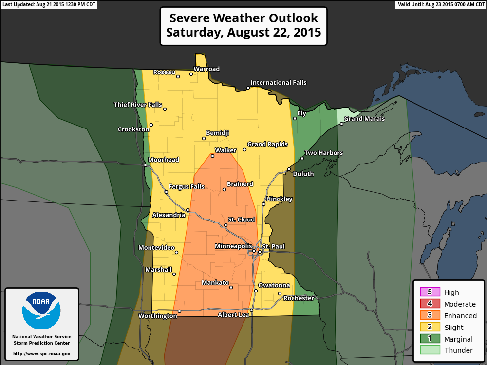
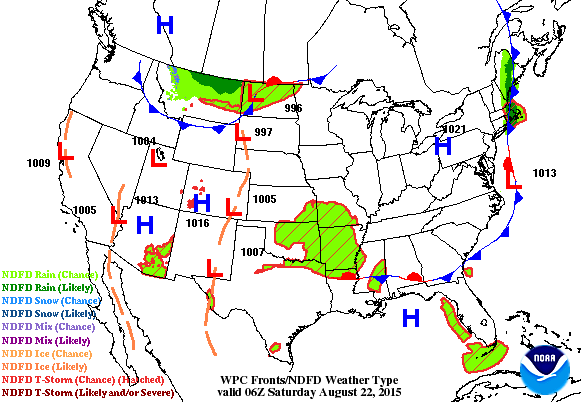
Saturday Severe Threat
The Storm Prediction Center has much of Minnesota under a risk of severe weather on Saturday. Hail and high winds look to be the primary threat, but a few tornadoes can't be ruled out. Warm, muggy and windy conditions will set the stage for some late afternoon/evening thunderstorms.
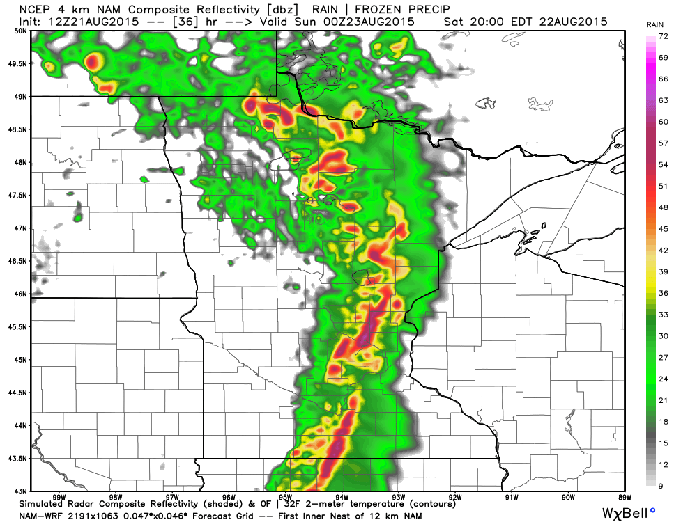
Simulated Radar 7pm Saturday
Here's the simulated radar for 7pm Saturday. Note the fairly robust line of storms that looks to moving through the central part of the state at that time. Keep in mind that the Vikings 3rd preseason game is slated for 7pm Saturday at TCF Bank Stadium, which is an open air stadium and could be impacted by the weather
Simulated Radar 7pm Saturday
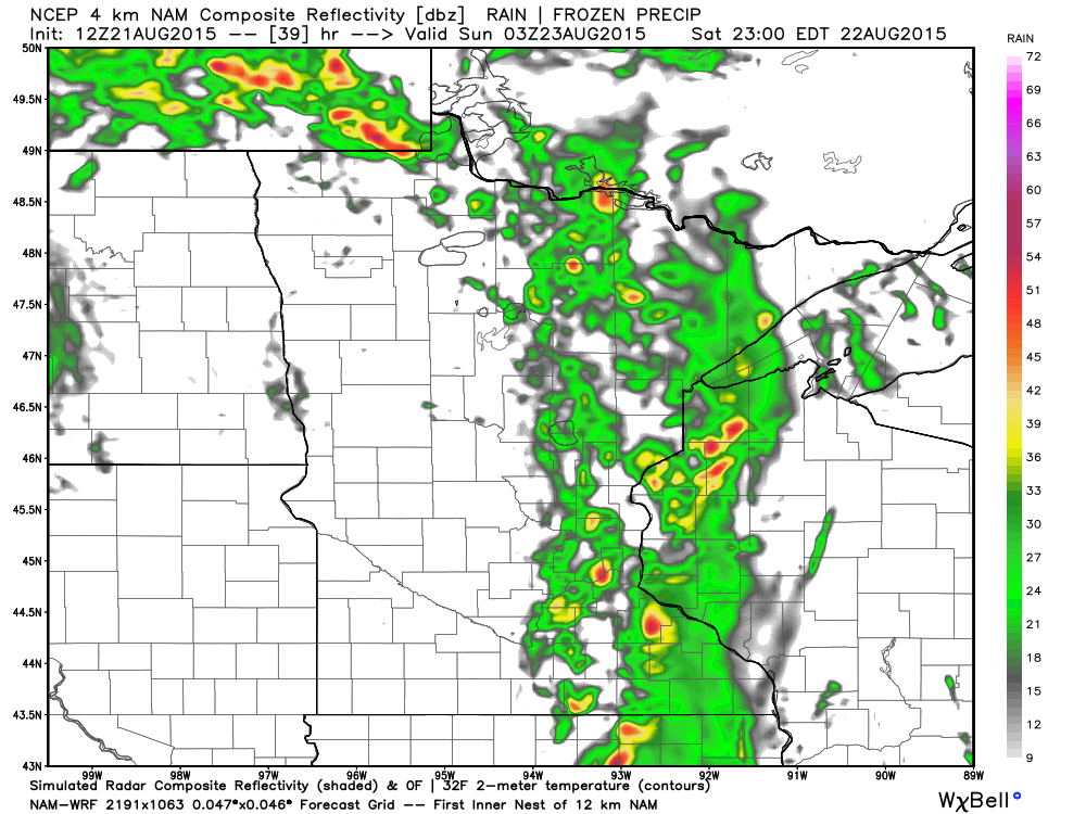
Simulated Radar 10pm Saturday
Scattered thunderstorms look to continue working east through the area by 10pm, some could be strong to severe...
___________________________
Thunder-Wear Alert
By Paul Douglas
What is it about the mutual attraction of severe storms and weekends? It's Saturday, so wear your hail-helmet, check radar on your phone and prepare snacks for quality time in your weather-bunker.
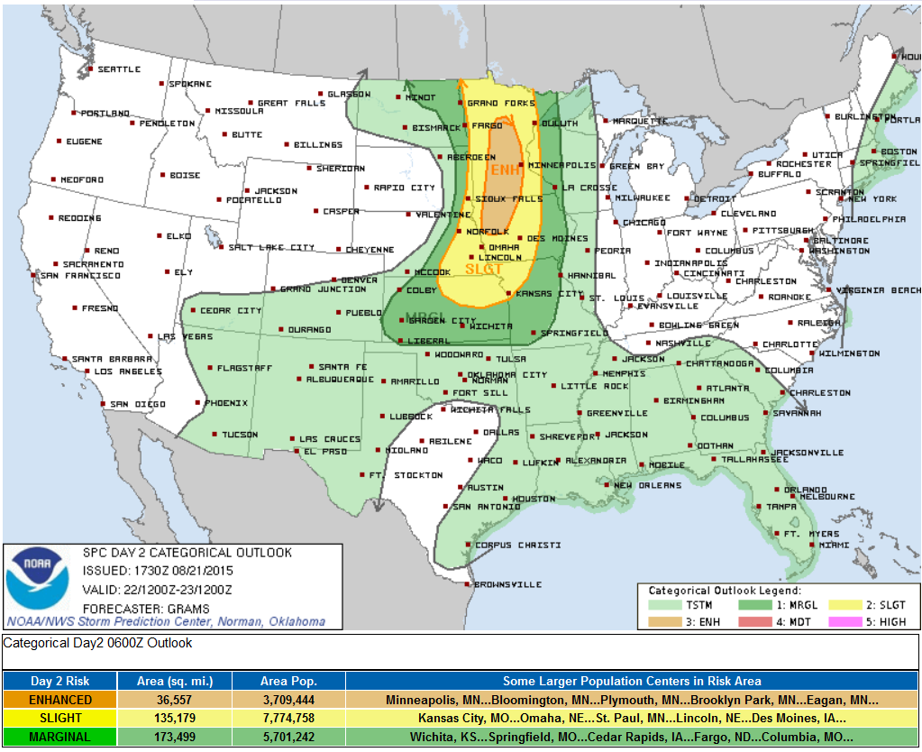
Strong to severe storms are imminent. NOAA SPC has an "enhanced risk" of severe storms over much of the state, meaning an elevated chance of damaging straight line winds capable of moderate damage, downed trees and power outages. A few isolated tornadoes may spin up out ahead of the main line, but the larger risk is straight-line winds exceeding 70 mph with a few of these storms. I expect to see watches and warnings by mid-afternoon. Stay alert and plan an escape route, just in case.
We've had a few bouts of wicked winds, but spring didn't bring widespread flooding like previous years. And SPC reports only 20 tornadoes in 2015, statewide, with no big headline-grabbing twisters, thank God.
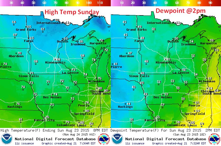
Skies begin to clear Sunday as gusty winds pull cool air southward. We'll be lucky to hit 70F Sunday thru Tuesday.
But don't pack away the shorts just yet: long-range guidance still brings 3-5 days of 90s into Minnesota the first week of September. Just in time for back-to-school! Lovely
___________________________
FRIDAY NIGHT: Parly cloudy, showers late?. Low: 67. Winds: S 10-15mph
SATURDAY: Breezy. Some AM sun, strong/severe PM storms. High: 83 Winds: S 15-30mph
SATURDAY NIGHT: Scattered storms early, then some clearing. Low: 58
SUNDAY: Showers north, windy and cooler. High: 70.
MONDAY: Fresh sun, feels like mid-September. Wake-up: 54. High: 71.
TUESDAY: Blue sky, just about perfect. Wake-up: 53. High: 73
WEDNESDAY: Parly sunny, warming up again. Wake-up: 57. High: 78.
THURSDAY: Some sun, a bit stickier. Wake-up: 59. High: 79
FRIDAY: A few showers & storm. Wake-up: 61. High: 80
_________________________________
This Day in Weather History
August 22nd
1910: Daylight is dimmed in Duluth due to smoke from Rocky Mountain forest fires.
1870: Downpours across southern Minnesota with 5 inches at Sibley, and 3.49 at Ft. Snelling. Much of the wheat crop was damaged.
__________________________________
Average High/Low for Minneapolis
August 22nd
Average High: 80F (Record: 97F set in 1971)
Average Low: 61F (Record: 43F set in 1890)
___________________________________
Sunrise/Sunset Times for Minneapolis
August 22nd
Sunrise: 6:23am
Sunset: 8:08pm
*Daylight lost since yesterday: ~2 minutes, 53 seconds
*Daylight lost since summer solstice (June 21st): ~1 hour, 51 minutes
___________________________________
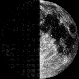
Moon Phase for August 22nd at Midnight
0.5 Since First Quarter
______________________________________
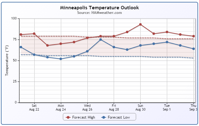
Minneapolis Temperature Trend
August-like temperatures will be with us again on Saturday, but note the big cool down by Sunday and early next week! It'll be Septemberish Sunday with temperatures dipping into the 60s with wind-whipped spits of rain. Gradually, we climb of a brief fall-like weather stint and head for mid summer readings by next weekend, just in time for the MN State fair!
________________________________
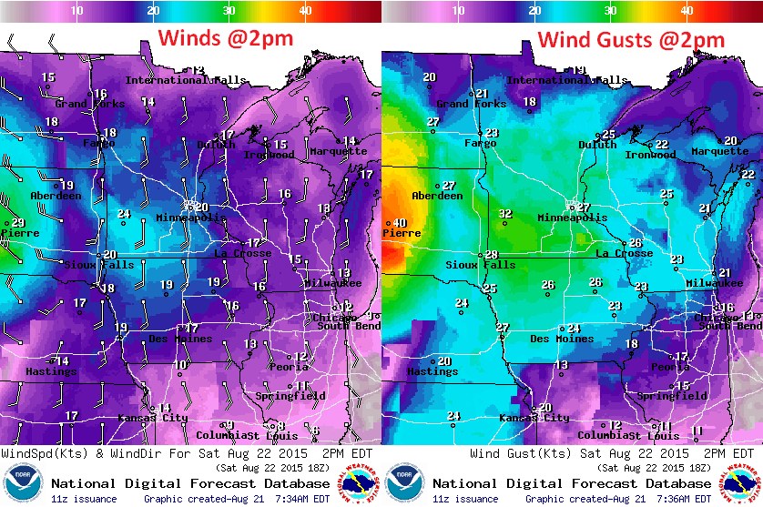
Saturday Weather Outlook
Temperatures on Saturday will warm to near average levels once again, but dewpoints will be in the mid/upper 60s making it feel quite muggy!
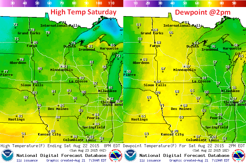
Saturday Weather Outlook
An approaching storm system will help to whip up south winds to 15mph-30mph across much of Minnesota on Saturday. This will be the warm, muggy air ahead of the cold front. Temperatures on Sunday behind the cold front will dip into the 50s & 60s across the region on Sunday
________________________________________
Sunday Weather Outlook
Grab your favorite sweatshirt for Sunday... Temperatures will struggle to get into the 60s for some locations, making it feel very much like a September/October day. Dewpoints will fall from the upper 60s to the upper 40s! For every 20 degree dewpoint drop, the amount of water in the atmosphere is cut in half... how about that.
Sunday Weather Outlook
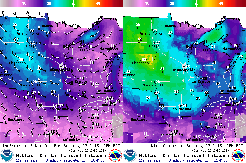
The wind field surrounding the are of low pressure will be quite strong, so Sunday will be another windy day with gusts approaching 30mph+. Cooler temps and wind-whipped spits of rain will make it feel more like September/October.
Sunday Weather Outlook
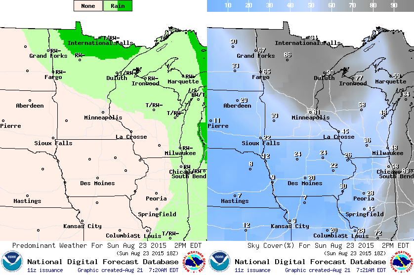
Wrap around rain showers will continue on Sunday with the heaviest/steadiest across the far northern part of the state.
___________________________________________
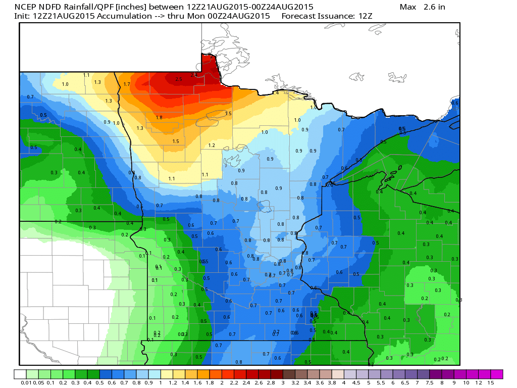
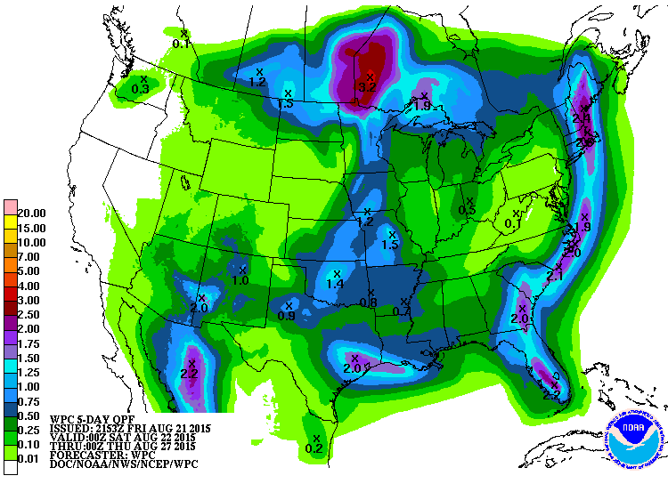
Rainfall Potential
A line of strong storms looks to develop PM Saturday with heavy pockets of rain. The heaviest/steadiest rainfall looks to be across the far northern part of the state through PM Sunday.
____________________________________
National Weather Outlook
The vigorous area of low pressure responsible for the strong to severe weather potential across the Midwest on Saturday is pretty evident in the loop below. Note how quickly it appears to intensify into the weekend.
Severe Threat Saturday
...SUMMARY... SCATTERED SEVERE THUNDERSTORMS ARE EXPECTED LATE SATURDAY AFTERNOON AND EVENING ACROSS THE UPPER MIDWEST AND LOWER MISSOURI VALLEY. DAMAGING WINDS...LARGE HAIL...AND A FEW TORNADOES WILL BE POSSIBLE. ...UPPER MIDWEST AND LOWER MO VALLEY... HAVE UPGRADED/EXPANDED SEVERE PROBABILITIES WITH INCREASED CONFIDENCE IN WIDESPREAD TSTM DEVELOPMENT AND A CONCENTRATED CORRIDOR OF GREATER SEVERE POTENTIAL ANTICIPATED FROM MN TO SERN NEB. VIGOROUS SHORTWAVE TROUGH CURRENTLY OVER SRN BRITISH COLUMBIA SHOULD DIG ESE INTO THE UPPER MS VALLEY BY 12Z/SUN. THIS WILL SUPPORT DOWNSTREAM CYCLOGENESIS WITH A RELATIVELY DEEP SURFACE LOW TRACKING FROM THE CNTRL DAKOTAS TO NWRN ONTARIO DURING THE PERIOD. A PLUME OF SEASONABLY RICH LOW-LEVEL MOISTURE CHARACTERIZED BY MEAN MIXING RATIOS OF 13-18 G/KG WILL BE ADVECTED N ON PERSISTENT SLYS FROM THE SRN PLAINS/WRN GULF ON D1. THIS SHOULD FOSTER MIDDLE 60S TO LOWER 70S SURFACE DEW POINTS BY SAT AFTERNOON AHEAD OF A COLD FRONT ADVANCING ESE ACROSS THE REGION. AN EXPANDING EML PLUME SHOULD PROVIDE SUFFICIENT CAPPING TO PRECLUDE OPEN WARM SECTOR DEVELOPMENT IN THE UPPER MIDWEST. LATE AFTERNOON TSTMS WILL LIKELY INITIATE AS A CONCENTRATED AREA OF HEIGHT FALLS/LARGE SCALE FORCING FOR ASCENT OVERSPREADS THE N/S-ORIENTED PORTION OF THE COLD FRONT NEAR THE DAKOTAS/MN BORDER. THIS ACTIVITY SHOULD BE ON THE ERN FRINGE OF A STRONG MID-LEVEL SWLY JET PROGGED TO LIE FROM NRN NEB INTO SWRN MN AT 23/00Z. GIVEN THE DEGREE OF FORCING ASCENT...CONVECTION SHOULD QUICKLY GROW UPSCALE INTO A SQUALL LINE WHICH MAY ACCELERATE ENE IN THE EARLY/MID-EVENING AS MID-LEVEL WINDS STRENGTHEN. INITIAL MIX OF SEVERE HAIL/WIND SHOULD BECOME A PREDOMINANT DAMAGING WIND RISK IN MN WITH A FEW EMBEDDED SUPERCELL/MESOVORTEX STRUCTURES CAPABLE OF TORNADOES.
Severe Threat Sunday
...SUMMARY... ISOLATED SEVERE THUNDERSTORMS ARE POSSIBLE FROM PORTIONS OF THE GREAT LAKES SOUTHWEST INTO THE MID-MISSISSIPPI VALLEY ON SUNDAY. ...SYNOPSIS... AN UPPER-LEVEL LOW WILL MOVE SLOWLY EAST ACROSS THE UPPER MIDWEST/NORTHERN GREAT LAKES ON SUNDAY WHILE HIGH PRESSURE ALOFT EXTENDS FROM THE GREAT BASIN SOUTHEAST INTO TEXAS. A SURFACE COLD FRONT WILL EXTEND FROM LOWER MICHIGAN SOUTHWEST THROUGH THE MID-MISSISSIPPI VALLEY AND SOUTHERN PLAINS LATE SUNDAY AFTERNOON. ...GREAT LAKES INTO MIDDLE MISSISSIPPI VALLEY... SHOWERS/THUNDERSTORMS WILL LIKELY BE IN PROGRESS SUNDAY MORNING ALONG THE FRONT FROM THE GREAT LAKES INTO THE SOUTHERN PLAINS. AS DIURNAL HEATING COMMENCES...THUNDERSTORMS WILL LIKELY INCREASE IN INTENSITY/COVERAGE ALONG THE FRONT. MOST FAVORABLE DEEP-LAYER SHEAR WILL REMAIN CONFINED TO THE GREAT LAKES/OHIO VALLEY REGION...WHERE A CORRIDOR OF WEAK-MODERATE SURFACE-BASED INSTABILITY WILL EXIST BY AFTERNOON. ISOLATED SEVERE THUNDERSTORMS APPEAR POSSIBLE DURING THE AFTERNOON/EARLY EVENING WITH DAMAGING WINDS THE MAIN THREAT.
Precipitation Outlook
________________________________________
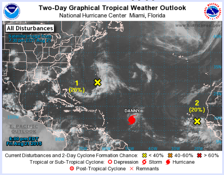
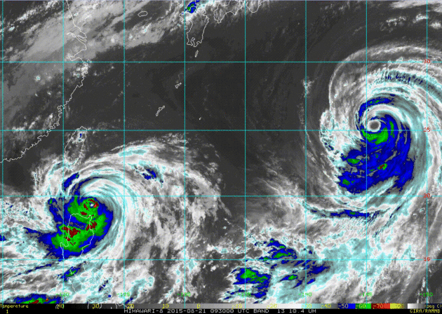
Atlantic Heating Up
The National Hurricane Center is keeping busy as of late with 3 areas of interest in the Atlantic Basin. The most prominent is Hurricane Danny, which as of PM Friday was still a category 3 hurricane!
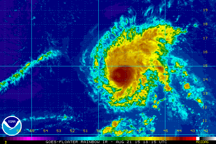
Hurricane Danny
Danny, a Category 3 hurricane in the Atlantic Ocean continue tracking west on Friday evening. The satellite loop below showed a pretty robust system with sustained winds near 100mph.
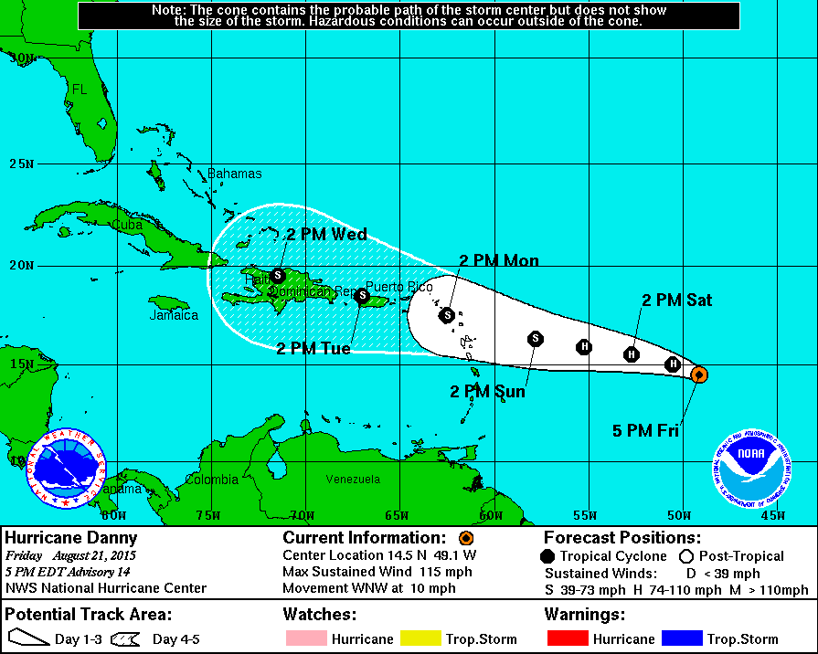
Tracking Danny
According to NOAA's NHC, Danny will track west toward the Caribbean over the coming days, but note the weakening that takes place early next week. Upper level winds are stronger, so shearing could weaken Danny into a tropical storm next week.
________________________________________
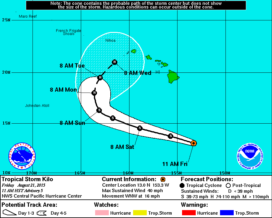
Kilo in the Central Pacific
The tropics seem to really be heating up. Here's another named storm, this time in the Central Pacific. Kilo was a tropical storm on Friday and is forecast to become a hurricane possibly be early next week.
Tracking Kilo
Weather conditions could get pretty interesting next week as Kilo tracks toward the small islands of Hawaii. Stay tuned!
________________________________________
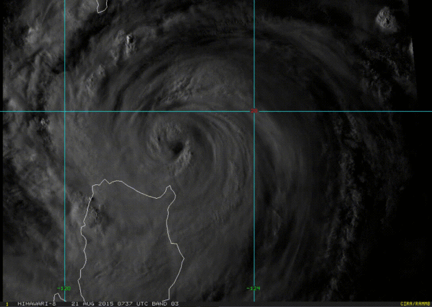
Pacific Problems
Menacing typhoon in the West Pacific look pretty impressive on the satellite loop below don't they? ATSANI on the right seems to be a little bigger, but GONI on the left is causing the most concern as it is impacting the Philippines and Taiwan.
GONI
Here's an interesting satellite loop of Typhoon GONI from the Himiwari-8 satellite. This was sundown Friday as the storm was located just north of the Philippines.
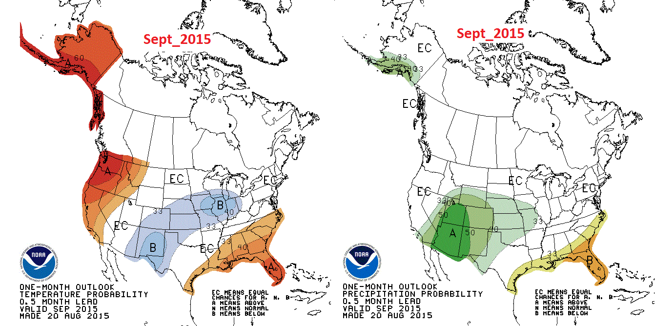
September Weather Outlook
NOAA's Climate Prediction Center recently released it's extended outlooks for September and for Fall. September suggests a good chance of above normal temps in Alaska and the Pacific Northwest. Below average temps may be possible throughout parts of the midsection of the nation. Precipitation chances look to stay above normal in the Desert Southwest.
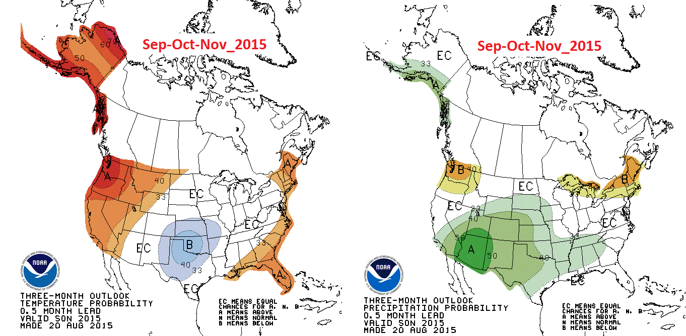
September - October - November Outlook
Meteorological Fall (Sep-Oct-Nov) could be warmer than average in Alaska and the Western U.S. with above average precipitation in the Southwestern part of the U.S.. Interestingly, some of the weather may be driven by the effects of El Nino in the Pacific Ocean. Stay tuned to see what happens.
_________________________________
Thanks for checking in and have a great weekend ahead! Don't forget to follow me on Twitter @TNelsonWX

No comments:
Post a Comment