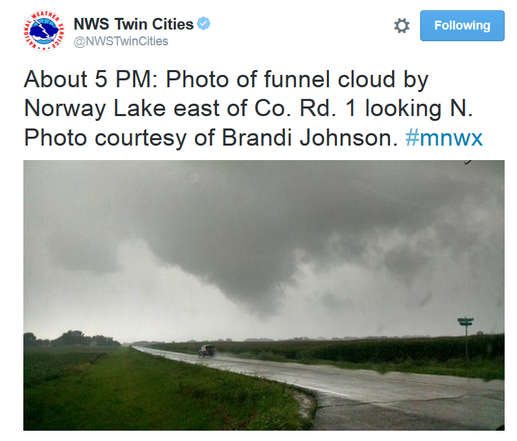
A tornado was reported in western Minnesota on Thursday evening near Norway Lake. Here was a tweet from the @NWSTwinCities and picture via Brandi Johnson.
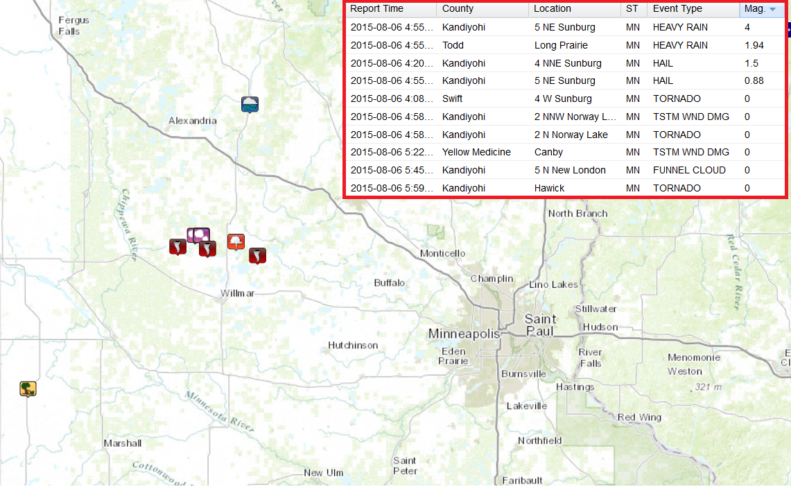
Thursday Evening Storm Reports
Note the several storm and tornado reports from the tornadic cell that developed on Thursday evening north of Wilmar. The storm was a pretty slow mover, so it also produced significant rainfall. There was a report of 4" near Sunburg.
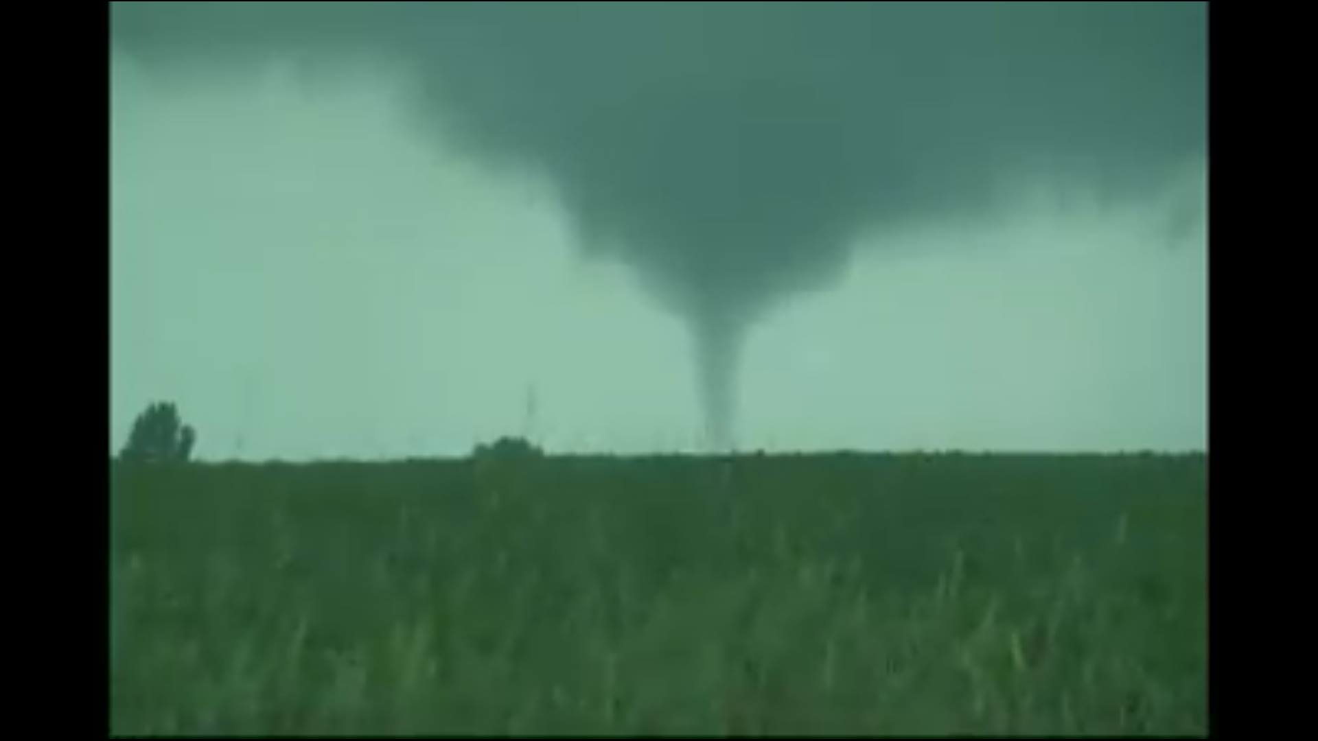
Thanks to Kory Hartman at SevereStudios.com for this still image of the tornado he caught on video Thursday evening near Paynesville. Great job Kory!!
Relative Risk
By Paul Douglas
Minnesota weather is not for the faint of heart. We see our fair share of traumatizing weather: recent wind damage from a series of microbursts was a blunt reminder that Mother Nature is prone to occasional tantrums.
"How do you live up there? Do you plug in your car when it gets cold? Wait - you can DRIVE on the lakes!" We get grief about our Minnesota winters but a steady volley of cold air inoculates us from the worst natural disasters. Since 1980 billion-dollar weather disasters were 3 times more likely from Texas to the Carolinas than Minnesota. No hurricanes at our lofty latitude. No volcanoes, earthquakes or tsunamis either.
It's easy to get swept up in the media's breathless disaster coverage but the day to day risk of deadly natural disasters here is relatively low. Feel better? Me neither.
Heavy showers and T-storms flaring up along a warm frontal boundary taper this morning - you should be able to afternoon and evening activities. Isolated storms sprout over the weekend with enough murky sun for low 80s.
Meanwhile California is dealing with "fire-nadoes" as Category 4 Super Typhoon Souledor takes aim at Taiwan. Our cold fronts are looking better and better.
_______________________________________
THURSDAY NIGHT: T-storms likely, some packing locally heavy rain. Low: 66. Winds: S 10mph
FRIDAY: Damp start, slow PM clearing. High: 81. Winds: S turning WNW 10mph
FRIDAY NIGHT: Partly cloudy and quiet. Low: 65. Winds: NW 5-10mph
SATURDAY: Hazy sun. Isolated T-showers. Winds: South 5-10. High: 85
SUNDAY: Fading sun, more noticeable humidity - stray storms late PM. Wake-up: 67. High: 83
MONDAY: Sunnier and drier. Wake-up: 66. High: 86
TUESDAY: Sunny and beautiful. Wake-up: 65. High: 85
WEDNESDAY: Warmer and stickier. DP: 65. Wake-up: 67. High: 87
THURSDAY: Hazy sun, hints of July. Wake-up: 68. High: 88.
_________________________________________
This Day in Weather History
August 7th
1968: 7.09 inches of rain fell at Mankato. 1,200 homes had slight to heavy damage. Highways 169 and 22 were blocked by mud slides.
1955: The climate record of George W. Richards of Maple Plain ends. He recorded weather data with lively notations on phenology and weather events. He began taking observations when he was eleven in 1883. He continued to take observations for 72 years, with 66 years as a National Weather Service Cooperator.
1896: Final day of a massive heat wave with 104 at Le Sueur and Mazeppa.
1863: Forest City observer sees what he calls a "perfect tornado." He noted that it "drove principally from west to east and lasted about one half hour."
__________________________________________
Average High/Low for Minneapolis
August 7th
Average High: 82F (Record: 98F set in 2001)
Average Low: 63F (Record: 45F set in 1972)
___________________________________________
Sunrise/Sunset Times for Minneapolis
August 7th
Sunrise: 6:05am
Sunset: 8:31pm
*Daylight lost since yesterday: ~2 1/2 minutes
*Daylight lost since Summer Solstice; June 21st: ~52 minutes
_____________________________________________
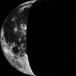
Moon Phase for August 7th at Midnight
1.2 Day After Last Quarter
_____________________________________________
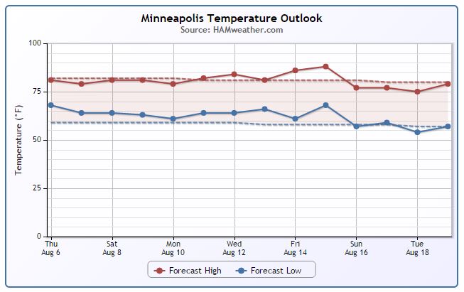
Minneapolis Temperature Trend
Can you believe that we've only seen two 90°+ days this year? According to NOAA's NCDC the average number of 90°+ days through early August is about eight. It appears that near average temperatures continue over the next several days with perhaps, a bit of a warm up by the end of next week... Still nothing significant.
________________________________________
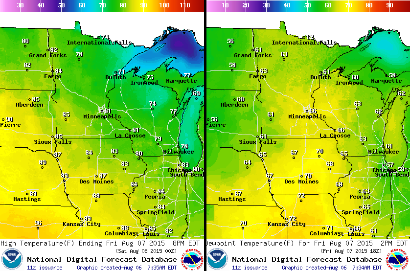
Friday Weather Outlook
Near average temperatures look to continue again on Friday with dewpoints still in the muggy zone. The warmest and stickiest stuff still looks like it will stay well south of us.
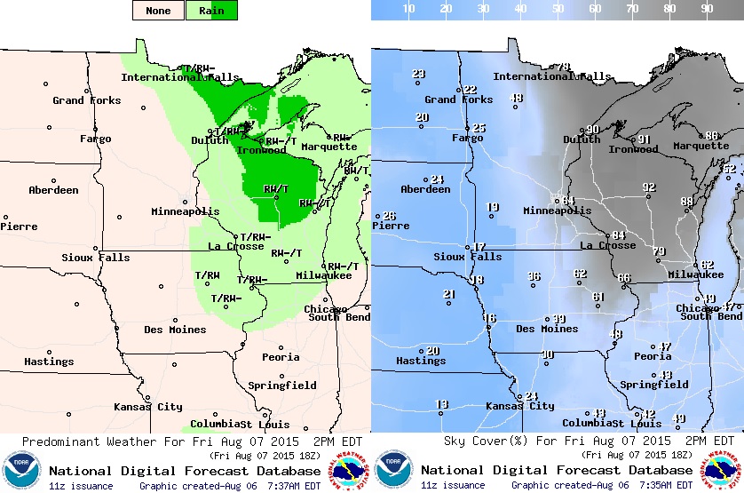
Friday Weather Outlook
Scattered showers and storms on Thursday will still be lingering across the region early Friday with some locally heavy downpours possible. Slow clearing will take place through the rest of the day with more PM sun
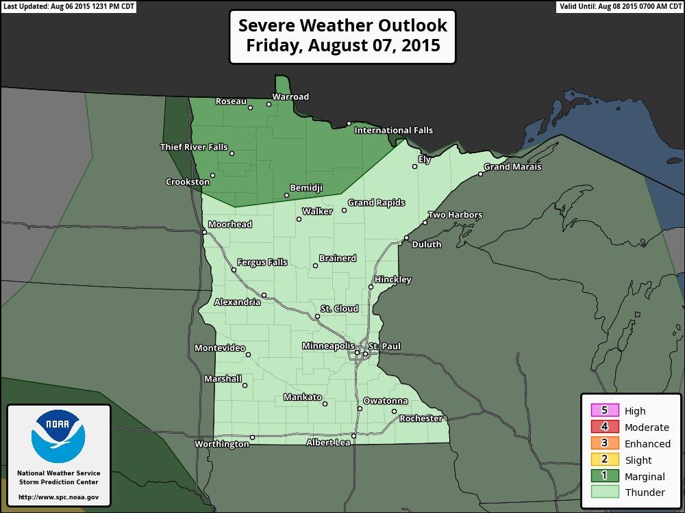
Severe Threat Friday
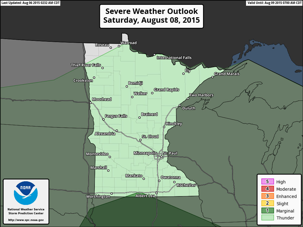
Severe Threat Saturday
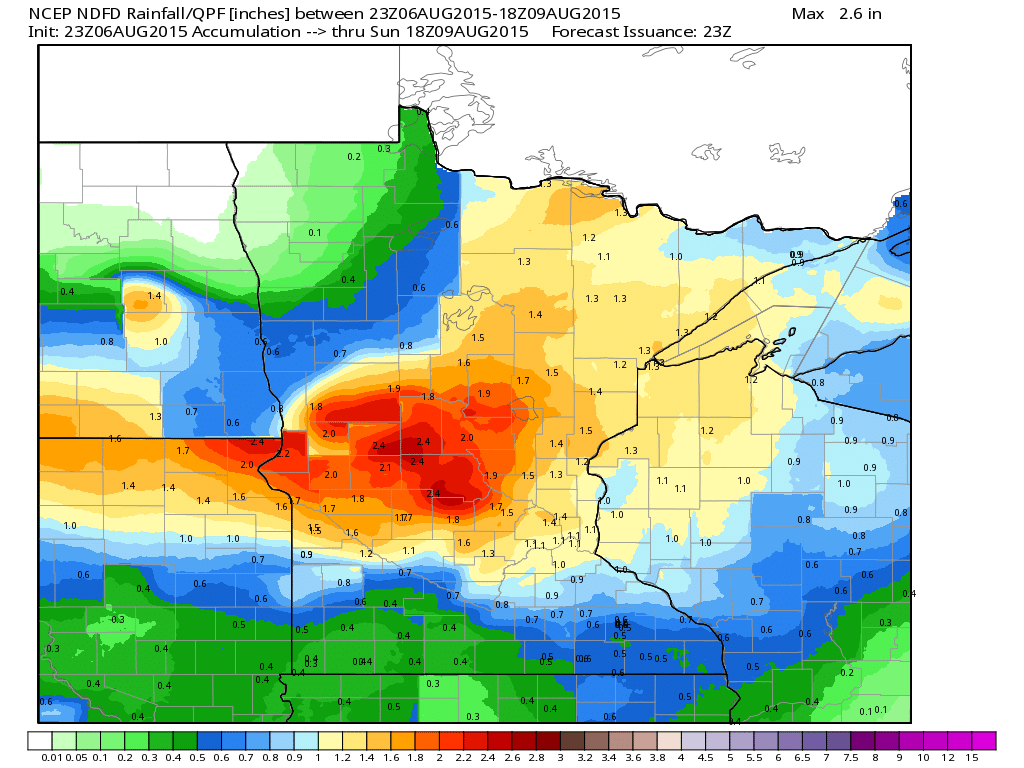
Rainfall Potential
The rainfall potential (Through midday Sunday) across the state looks quite impressive in the image below, but keep in mind that much of the accumulation was expected during the PM Thursday through AM Friday time frame. Additional T-showers will be possible on Saturday and Sunday, but it looks quite a bit more spotty.
_____________________________________
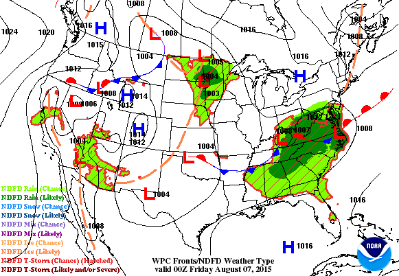
National Weather Outlook
Heavy rainfall across parts of the Upper Midwest will begin to fade during the day Friday, but another area of rain and thunder will move up from the Southwest over the weekend. Additional heavy rain and potentially strong/severe storms will be possible across the southeastern part of the country.
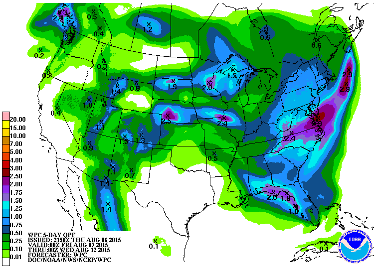
5 Day Precipitation Outlook
According NOAA's WPC, the heaviest rainfall over the next 5 days will be in pockets across the Midwest and along the eastern U.S.. Note that California looks to stay mostly dry.
____________________________________
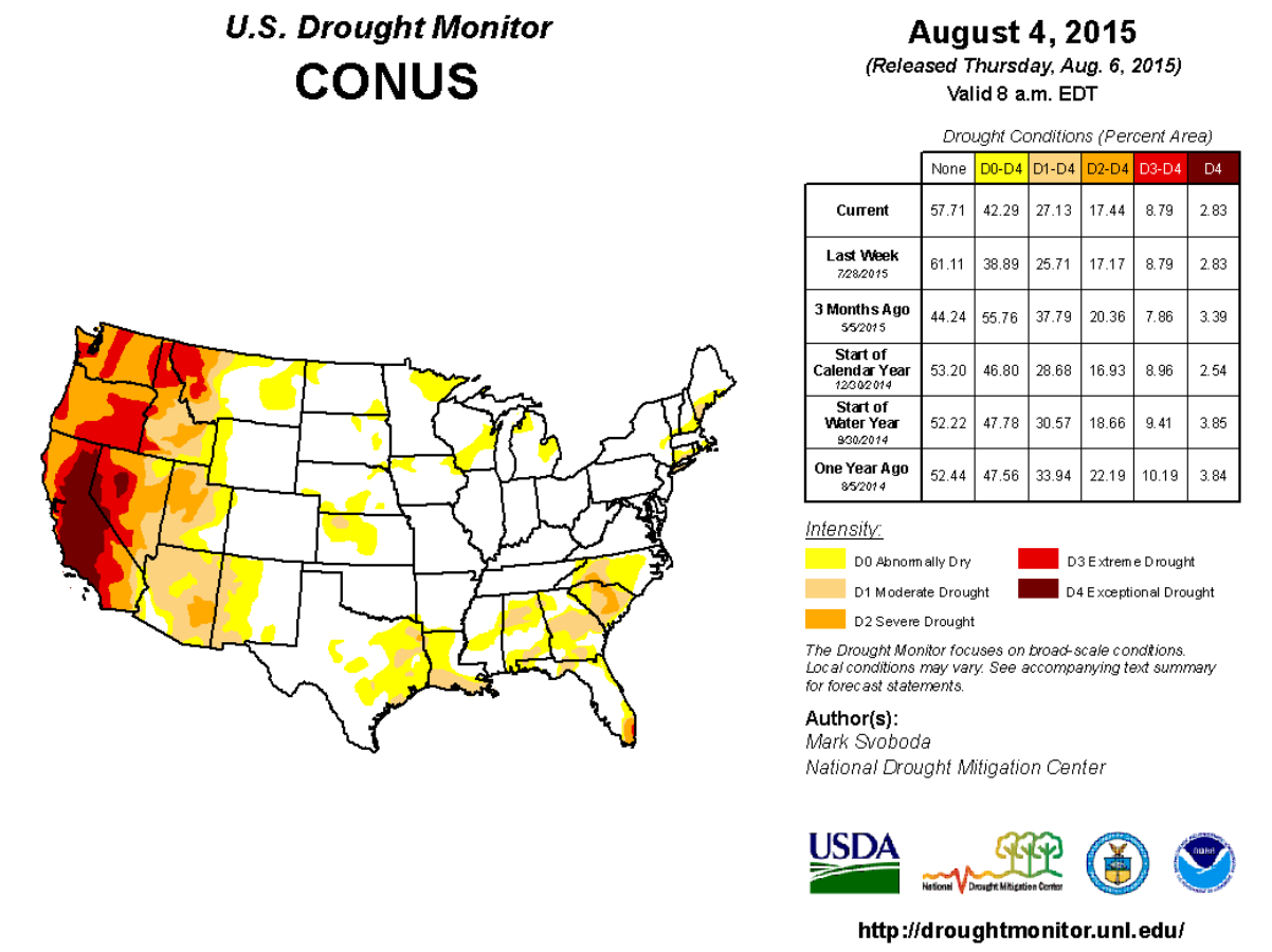
U.S. Drought Monitor
According to the U.S. Drought Monitor, nearly 42% of the nation is considered to be abnormally dry. Note that nearly 3% of the nation is in the worst drought classification (Exceptional Drought) and most of that is in California.
______________________________________
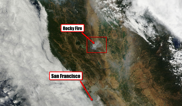
Rocky Fire on Visible Satellite
As of Wednesday, August 5th, the Rocky fire (located north of San Francisco, CA) had consumed nearly 70,000 acres and was only 30% contained. Unfortunately, several structures have been destroyed: 43 residences and 53 outbuildings destroyed; 8 structures damaged. And the fire is threatening nearly another 7,000 structures.
See more from CalFire HERE:
____________________________________________
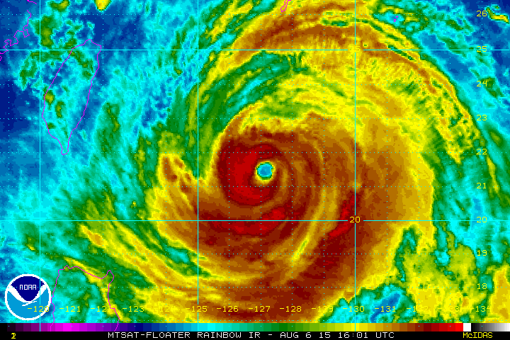
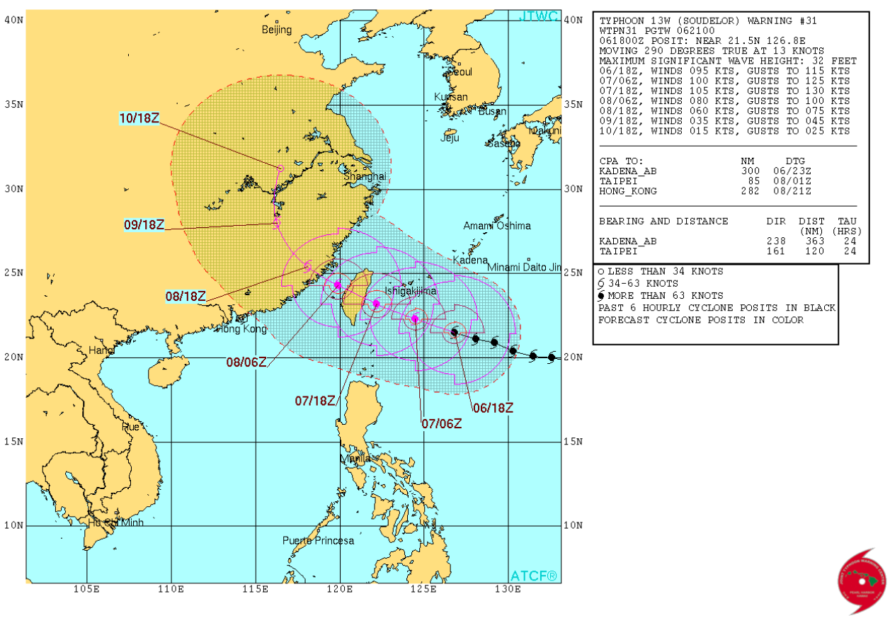
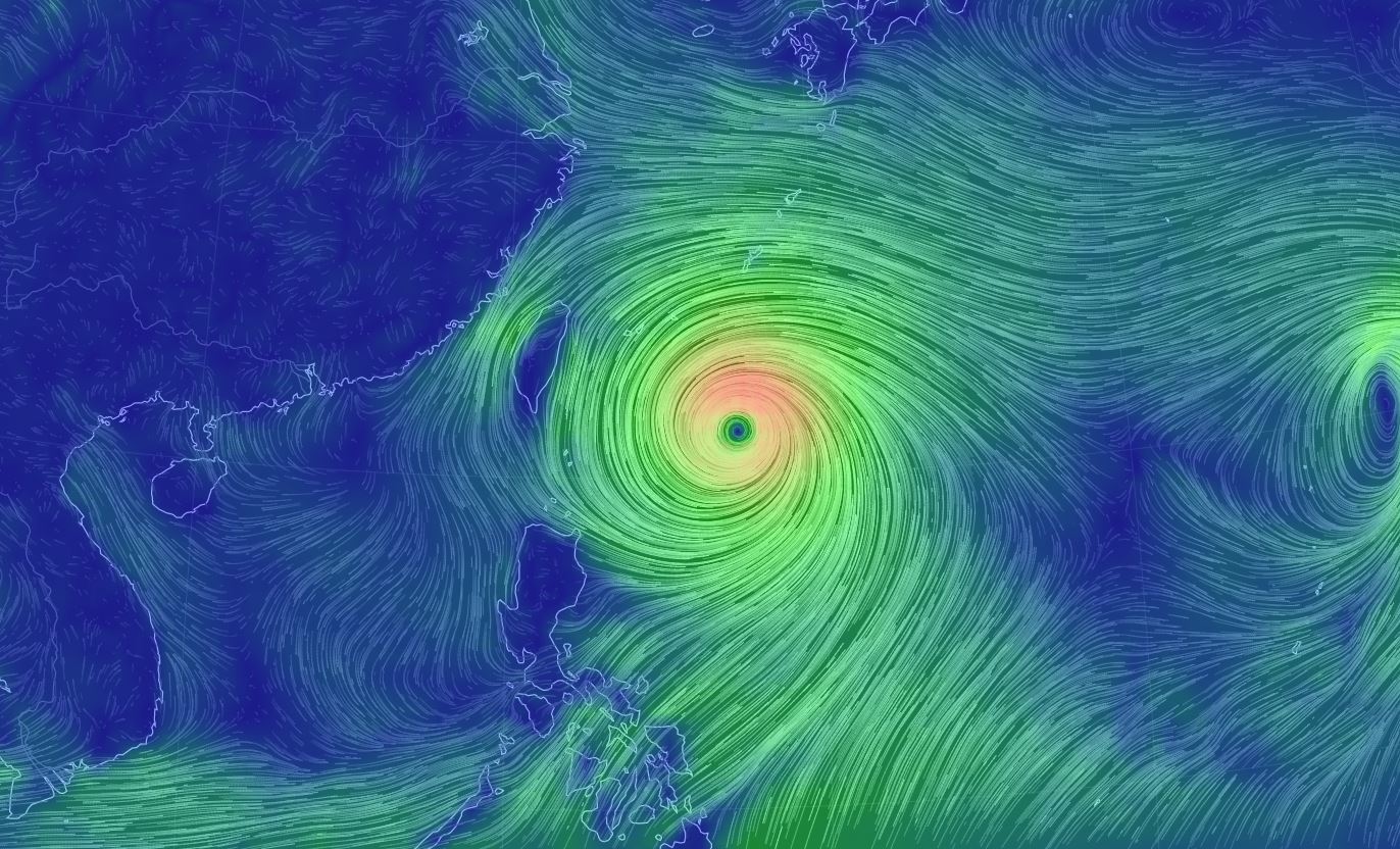
Typhoon Soudelor
The satellite loop of Typhoon Soudelor from Thursday evening showed a well defined eye with the sustained winds at nearly 110mph; high end category 2 hurricane equivalent. The forecast calls for additional intensification to a potential category 3 hurricane equivalent (winds near 120mph) just prior to making landfall with Taiwan. Quick weakening will take place thereafter as Soudelor move over inland eastern China this weekend.
See the animated wind field of Typhoon Soudelor HERE:
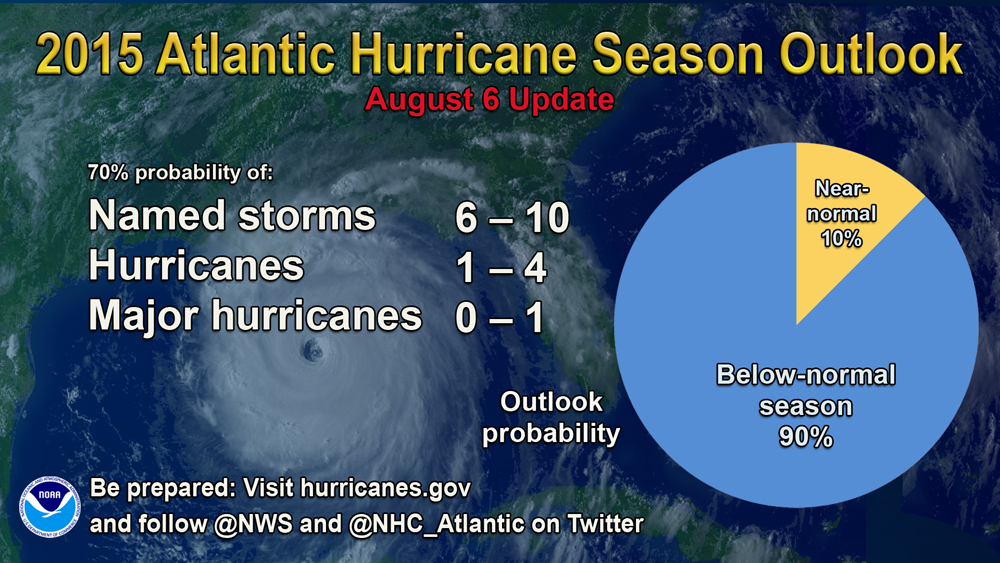
Atlantic Hurricane Season: 90% Chance Below Average
Forecasters attribute the high likelihood of a below-normal season to three primary factors:
*El Niño has strengthened as predicted, and NOAA’s latest El Niño forecast calls for a significant El Niño to continue through the remainder of the hurricane season;
*Atmospheric conditions typically associated with a significant El Niño, such as strong vertical wind shear and enhanced sinking motion across the tropical Atlantic and Caribbean Sea, are now present. These conditions make it difficult for storms to develop, and they are predicted to continue through the remaining four months of the hurricane season; and
*Tropical Atlantic sea-surface temperatures are predicted to remain below average and much cooler than the rest of the global tropics.
See the full story from NOAA HERE:
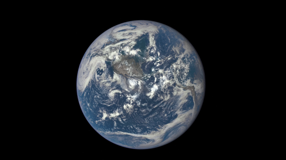
Dark Side of the Moon?
Thanks to NASA's Deep Space craft, we can now get a glimpse of the dark side of the moon.
"In an unusual treat for astronomers, and perhaps Pink Floyd fans, what is often known as the dark side of the moon has been captured, fully illuminated, by a camera aboard a Nasa satellite. The series of images taken from Nasa’s Deep Space Climate Observatory show a view of the far side of the moon, as it is more formally known, as it moved in front of the sunlit side of Earth. The images, taken on 16 July, show the moon moving across the Pacific Ocean towards North America. Its far side is shown in detail owing to sunlight hitting it, revealing a crater and a large plain called the Mare Moscoviense. Earth-bound observers see only one side of the moon because it is tidally locked to our planet, meaning its orbital period is the same as its rotation around its axis. The images of the far side of the moon, which wasn’t seen by humankind until a Soviet mission in 1959, will be captured about twice a year by Nasa’s observatory, which is primarily monitoring solar winds. “It is surprising how much brighter Earth is than the moon,” said Adam Szabo, a scientist at Nasa’s Goddard Space Flight Center. “Our planet is a truly brilliant object in dark space compared to the lunar surface.” Associate Professor Michael Brown, an astronomer at Monash University, said the images of the far side of the moon were “captivating”."
See more from TheGuardian.com HERE:
Thanks for checking in and have a great rest of your week! Don't forget to follow me on Twitter @TNelsonWX

No comments:
Post a Comment