It's hard to remember any days so far this summer that resembled Thursday's cloudy/soggy conditions. If you think about it, we really have been spoiled this year. It hasn't been too hot or too cold and we've had sufficient moisture to nix the drought statewide! Here's to hoping the last part of our summer continues the trend!
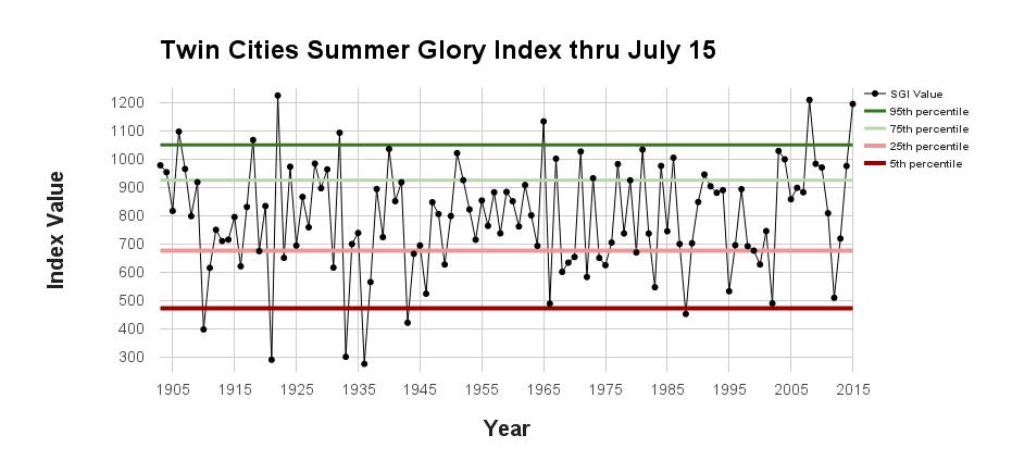
MSP "Glory" Index
According to UMN's Climate Office, Minneapolis has seen its 5th most glorious summer on record (through August 4th)! Here are the numbers to back up that theory in an article posted by the MN DNR:
The all-new Summer Glory Index (SGI) can help us answer these questions. Any day from June through August can earn up to 40 Glory points for being within “ideal” temperature, dew point, and precipitation ranges, and can lose points for being too hot, cold, wet, or humid. A given year’s SGI is then the sum of all the points earned and lost, and tells us how frequently we’ve experienced glorious conditions. Like its counterpart, the Winter Misery Index, the SGI allows us to compare individual summers to the historical record.
Through July 15, this summer had been the 3rd most glorious on record. Only 1922 and 2008 were better. Our current high ranking should come as no surprise: Through July 15th, Minneapolis had only topped 90 degrees once, had not recorded a minimum temperature of 70 or greater, had only had one 6 PM dew point reading above 70 degrees, and had just two calendar days with over an inch of rain.
Of course, there is no guarantee that the second half of summer will match the first half’s splendor. Nine of the top-10 summers up through July 15th slipped to between 19th and 69th for the second half of the season, and the summer of 1940, after a stellar first half, had one most miserable second halves on record. Stay tuned to find out how this currently-spectacular summer finishes.
Read the full story from MN DNR HERE:
_______________________________________
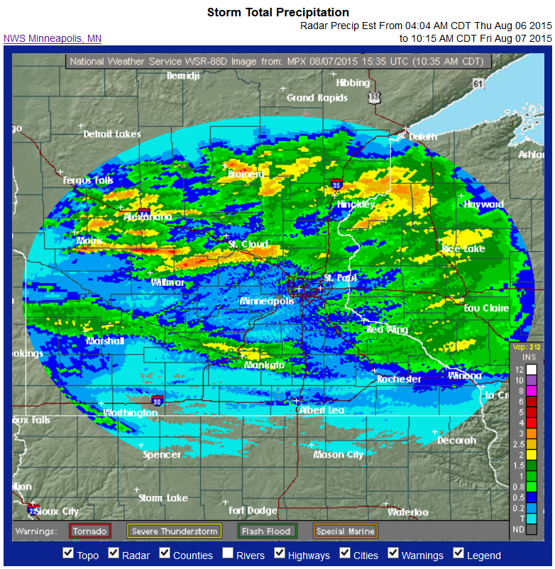
Thursday Rainfall
The image below shows how much rain fell based on radar estimates from AM Thursday to AM Friday. Note that the Twin Cities didn't see as much as areas across central Minnesota and into Wisconsin. Some of the heaviest rainfall occurred along and just south of the I-94 corridor with radar estimates suggesting nearly 2" to 4"+ in spots. That is also the area that saw large hail and tornadoes from a supercell that developed Thursday evening.
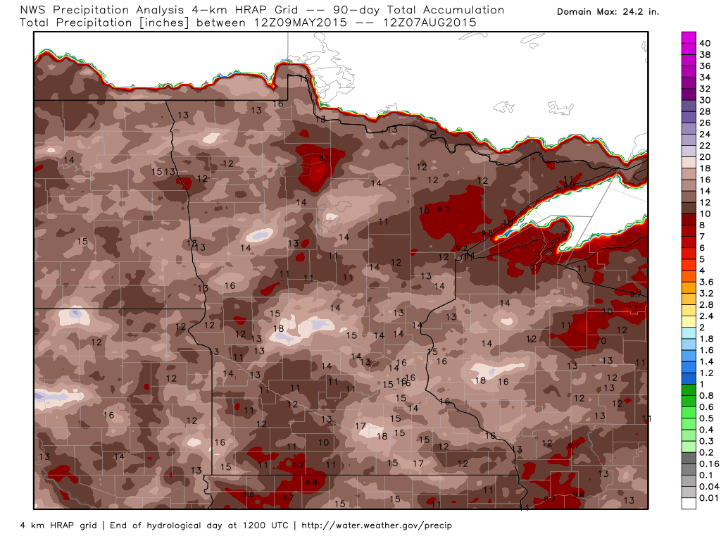
Rainfall: Past 90 Days
Here's an interesting product from WeatherBell that shows how much rain has fallen over the past 90 days (since early May). Note that much of the state has seen nearly double digits tallies with some locations even seeing close to 15" to 18" or more!!
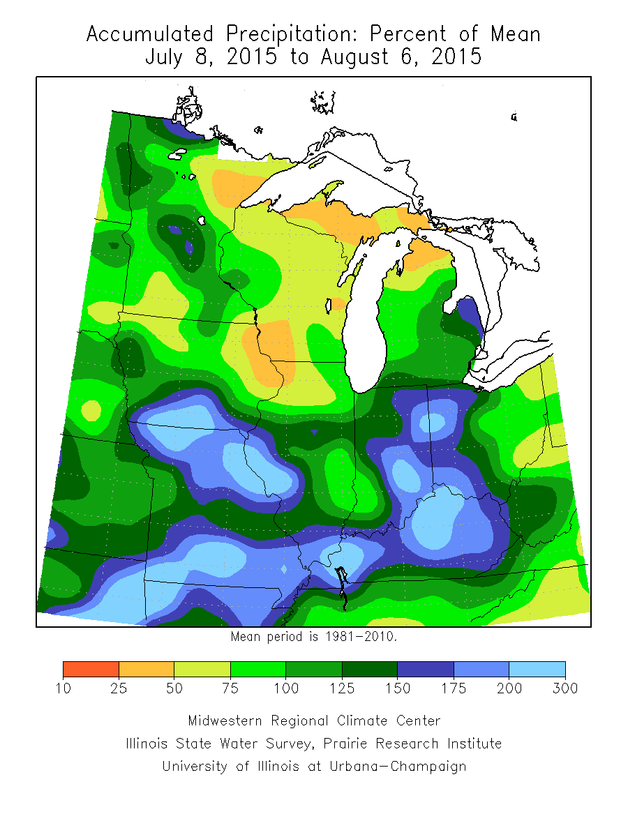
Percent of Average Precipitation: Past 30 Days
The image below from the Midwestern Regional Climate Center shows the percent of average precipitation over the last 30 days (since early July). Note that much of the state has seen near to slightly above average precipitation, but parts of northeastern Minneasota have only seen 25% to 50% of average. Interestingly, this has had an impact on the abnormally dry conditions that have popped up on the U.S. Drought Monitor seen in the section below.
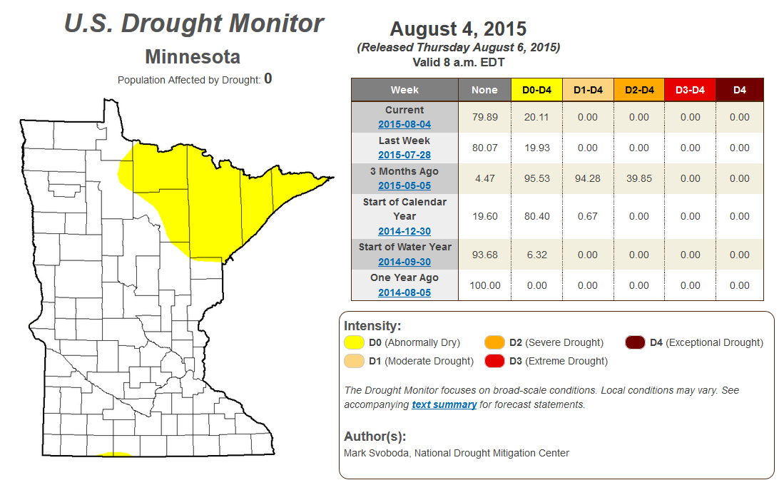
Minnesota Drought: Released Thursday, August 6th, 2015
According to the U.S. Drought Monitor, no part of Minnesota was classified under any drought, however, nearly 20% of the state was considered to be abnormally dry (mainly across NE Minnesota). Interestingly, 3 months ago, nearly 40% of the state was considered to be under severe drought conditions! Thanks to recent summer rains, we've really been able to squash any drought concerns.
________________________________________
Weather Trauma
By Paul Douglas
And how does one become a meteorologist? "Not smart enough to be a doctor, lawyer or engineer Paul?" Guilty. Growing up I delivered newspapers (on a minibike), washed dishes at a local Sheraton and slung burgers at McDonalds. Weather wasn't even on my radar.
And then came Agnes, Tropical Storm Agnes, which stalled over my home in Lancaster, Pennsylvania in 1972. We picked up 18 inches of rain; a man drowned in the stream behind our house. Agnes flooded our home; I still remember swimming in my basement, trying to plug up a gusher of cold, muddy water. That was the defining moment. How could this happen? Why wasn't there more warning?
Here's a dirty little secret: most TV meteorologists were traumatized by weather as kids. A tornado, flood, or blizzard - something put the fear of God into them. Because who in their right mind wants a gig where you're wrong much of the time, in public, without a safety net? "You're just a weatherman!" Paul Magers liked to joke. Yep.
The NAM model prints out over 2 inches of rain from T-storms tonight. The best odds of puddle-free weather: this morning and midday, again PM hours Sunday. Next week looks generally dry with a slow warming trend.
________________________________________
FRIDAY NIGHT: Partly cloudy. Low: 65. Winds: ENE 5-10mph
SATURDAY: Some sun. Heavy PM storms. Winds: South 10. High: 82. Winds: S 5-10.
SATURDAY NIGHT: Spotty showers/storms ending early. Low: 65. Wind: S 10.
SUNDAY: Storms early, some PM clearing. High: 79
MONDAY: Partly sunny, less humid. DP: 59. Wake-up: 66. High: 79
TUESDAY: Bright sun, light winds. Very nice. Wake-up: 63. High: 80
WEDNESDAY: Warm sunshine. No weather drama. Wake-up: 65. High: 84
THURSDAY: Partly sunny. Stickier. DP: 64. Wake-up: 67. High: 88.
FRIDAY: Hot sun. Feels like July. Wake-up: 69. High: 88.
__________________________________________
This Day in Weather History
August 8th
1930: A record high of 102 is set at Redwood Falls.
__________________________________________
Average High/Low for Minneapolis
August 8th
Average High: 82F (Record: 96F set in 2010)
Average Low: 63F (Record: 47F set in 1888)
___________________________________________
Sunrise/Sunset Times for Minneapolis
August 8th
Sunrise: 6:06am
Sunset: 8:30pm
*Daylight lost since yesterday: ~2 1/2 minutes
*Daylight lost since summer solstice (June 21st): ~1hr 13minutes
____________________________________________
Moon Phase for August 8th at Midnight
2.2 Days After Last Quarter
______________________________________________
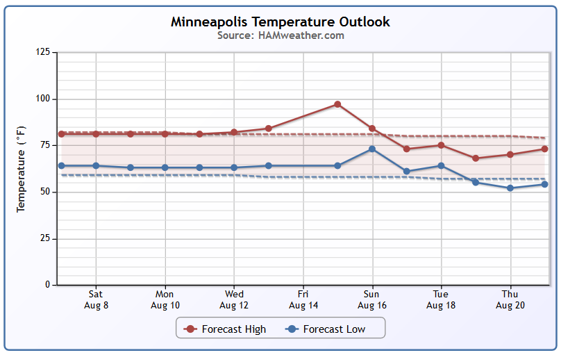
Minneapolis Temperature Trend
I am amazed by the lack of excessive heat close to home this summer. Near average temperatures look to continue through early next week with warmer temperatures possibly moving in by late next week/weekend.
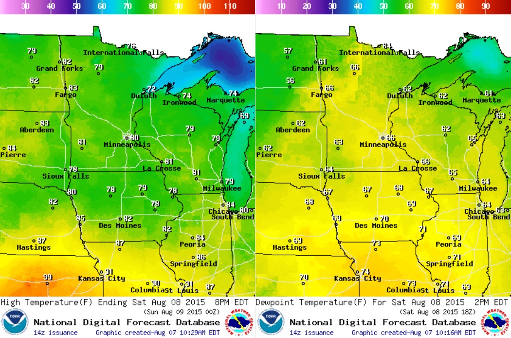
Saturday Weather Outlook
No surprises here. Near average temperatures look to continue on Saturday with sticky dewpoints in the 60s. Pretty typical for August... what else would you expect?
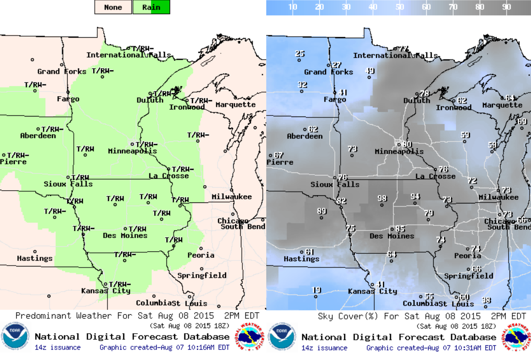
Saturday Weather Outlook
Somewhat unsettled weather will be with us on Saturday. I don't see an all day rain upon us, but some spotty stuff may develop with locally heavy downpours possible.
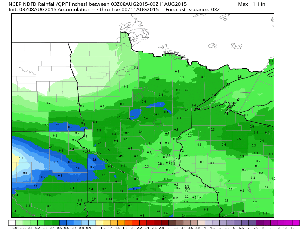
Rainfall Potential Through
Rainfall potential through early next week looks somewhat heavy in pockets. Keep in mind that spotty thunderstorms could produce locally heavier rainfall amounts than what is projected below.
________________________________________
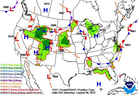
National Weather Outlook
Intense heat across south-central part of the country will keep most of the shower and thunderstorm potential on its our periphery. Note how the rainfall potential looks to move in an arc-like fashion from the Four Corners region to the Midwest. Within these areas, a few storms could be severe with locally heavy rainfall.
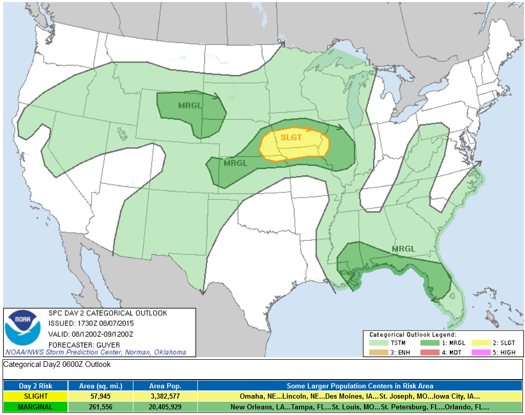
Severe Threat Saturday
...SUMMARY... SEVERE THUNDERSTORMS ARE EXPECTED SATURDAY FROM PARTS OF THE CENTRAL PLAINS TO THE MISSOURI VALLEY AND MIDWEST. OTHER STRONG TO SEVERE THUNDERSTORMS WILL BE POSSIBLE ACROSS OTHER PORTIONS OF THE HIGH PLAINS AND SOUTHEAST STATES.
...SYNOPSIS... ON THE NORTHERN PERIPHERY OF AN UPPER-LEVEL RIDGE CENTERED OVER THE SOUTHERN PLAINS/ARKLATEX...A PROGRESSIVE/MODERATELY STRONG CORRIDOR OF RELATIVELY LOW-AMPLITUDE WESTERLIES WILL EXTEND FROM THE GREAT BASIN/ROCKIES TO THE UPPER MIDWEST AND MID-ATLANTIC/NORTHEAST STATES ON SATURDAY.
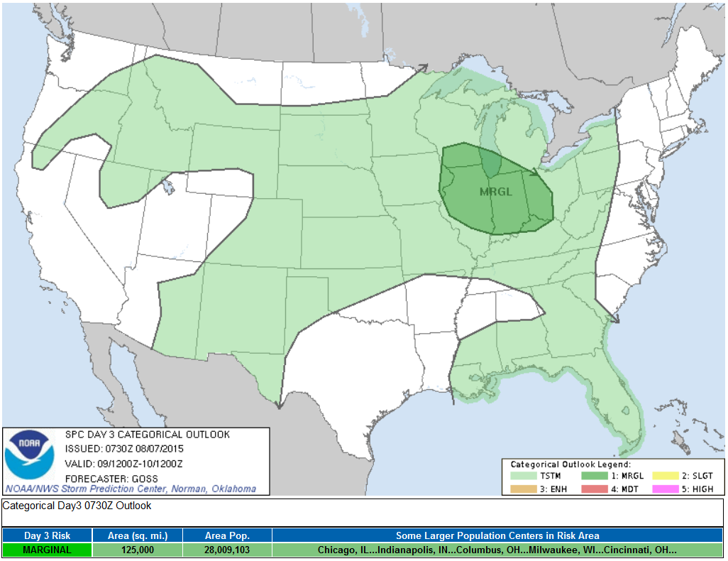
Severe Threat Sunday
...SUMMARY... A FEW STRONG/LOCALLY SEVERE STORMS WILL BE POSSIBLE SUNDAY ACROSS THE MIDWEST. ...SYNOPSIS... A PERSISTENT LONGER-WAVELENGTH/BACKGROUND UPPER FLOW PATTERN -- FEATURING A WRN TROUGH/CENTRAL RIDGE/ERN TROUGH -- IS EXPECTED TO PERSIST ACROSS THE U.S. DAY 3...THOUGH SOME AMPLIFICATION OF THE FLOW FIELD IS EXPECTED WITH TIME. THIS AMPLIFICATION WILL OCCUR AS A LOW JUST OFF THE SWRN CANADA/NWRN U.S. COAST ADVANCES GRADUALLY SEWD...WHILE A TROUGH OVER ONTARIO BEGINS DIGGING SEWD ACROSS THE GREAT LAKES. AT THE SURFACE...EXPECT THE PATTERN TO REMAIN RELATIVELY WEAK/NONDESCRIPT THROUGH THE PERIOD.
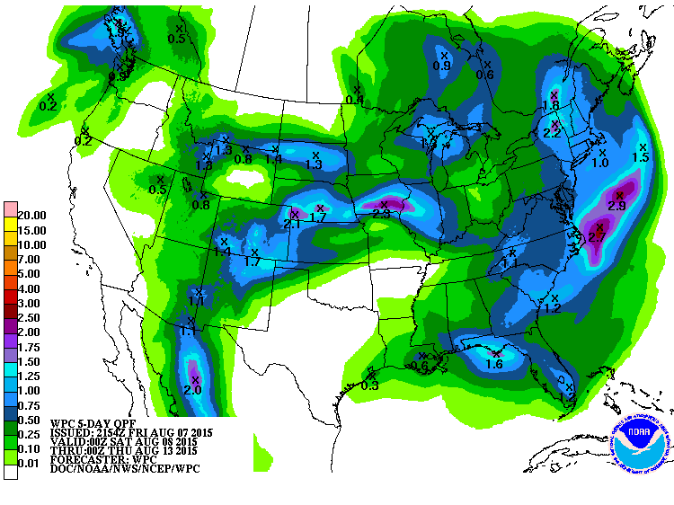
5 Day Precipitation Outlook
Pockets of heavy rain look to fall in an arc-like fashion from the Desert Southwest to the Midwest to the Mid-Atlantic around the intense heat in the southern U.S.
______________________________________
Typhoon Soudelor
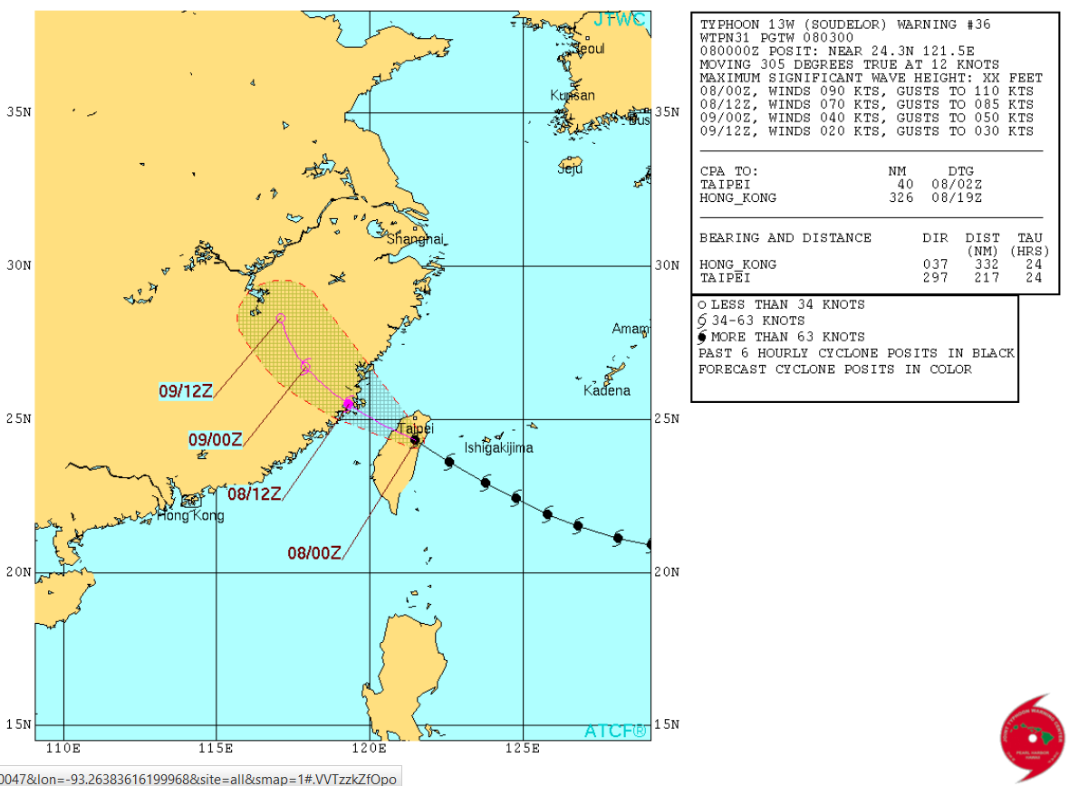
According to the Joint Typhoon Warning Center, Typhoon Soudelor was an equivalent mid tier category 3 hurricane with sustained winds of near 130mph just prior to making landfall with Taiwan on Friday CDT. Intense winds and significant rainfall was on track to batter the small island in the Western Pacific.
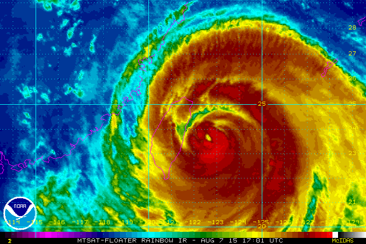
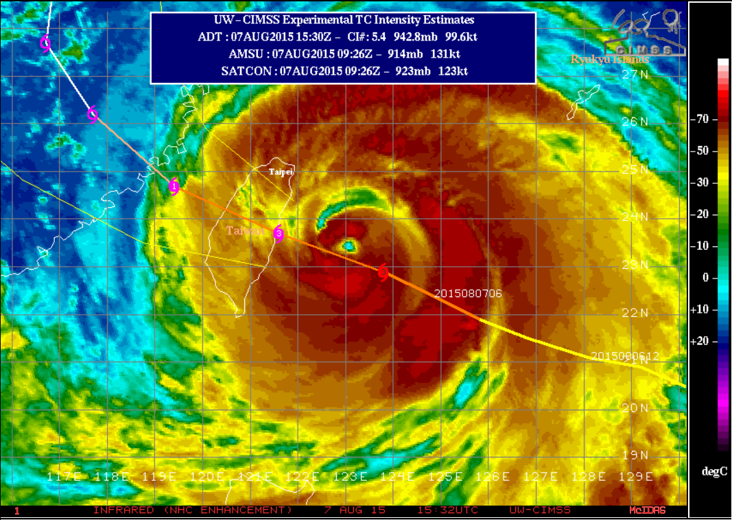
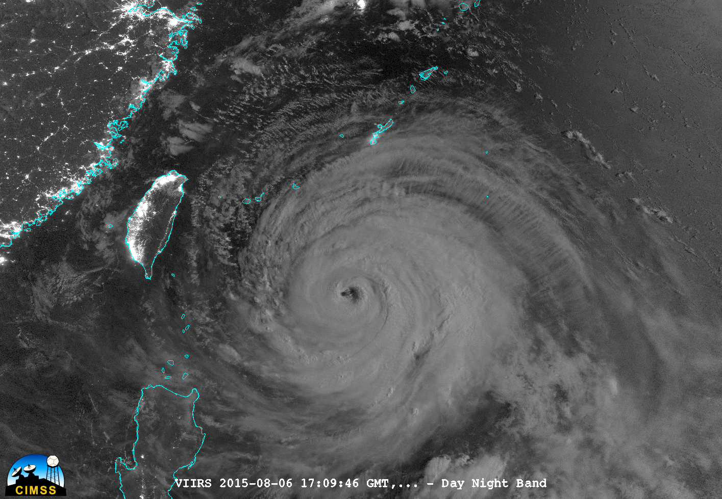
Incredible Soudelor Imagery
The CIMSS Satellite Blog from the University of Wisconsin is pretty amazing and has a lot of great imagery from Soudelor over the last several days. Keep in mind that earlier this week, Soudelor had satellite derived wind speeds sustained at near 180mph with gusts to near 220mph! This will likely be one of the strongest storms on the globe in 2015... think about that!
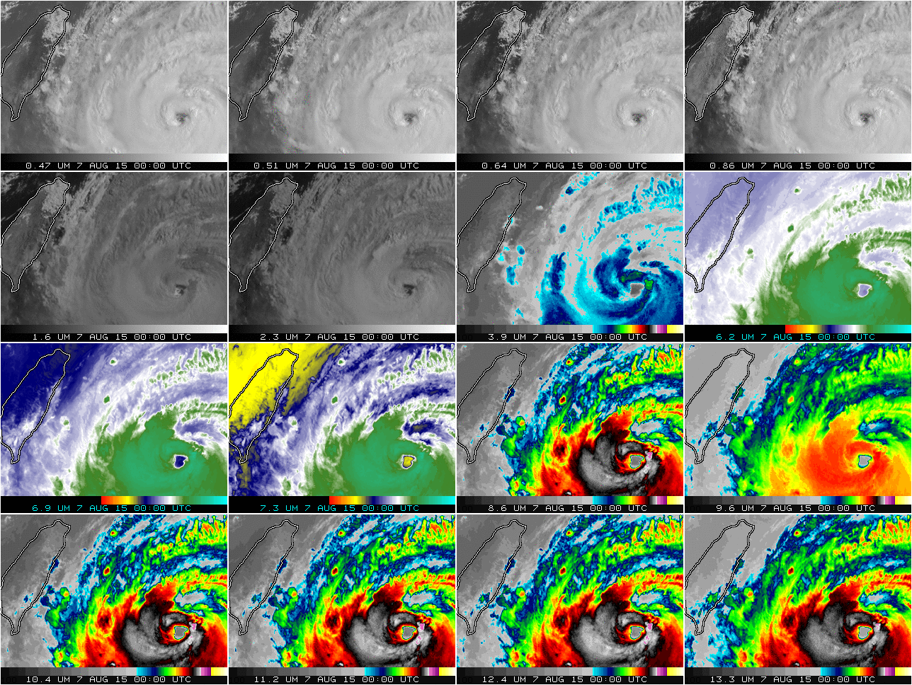
"The 16-channel animation from Himawari-8, below, at half-hour steps from 0000 through 1230 UTC on 7 August, shows plain evidence of dry air at mid-levels increasing with time, first northeast of the storm and later west of the storm (especially in the ‘water vapor channels: 6.2 µm, 6.9 µm and 7.3 µm)."
See more from the CIMSS Satellite Blog HERE:
Soudelor Track
According to the Joint Typhoon Warning Center, the track takes Soudelor over Taiwan on Friday into eastern China on Saturday CDT.
____________________________________________
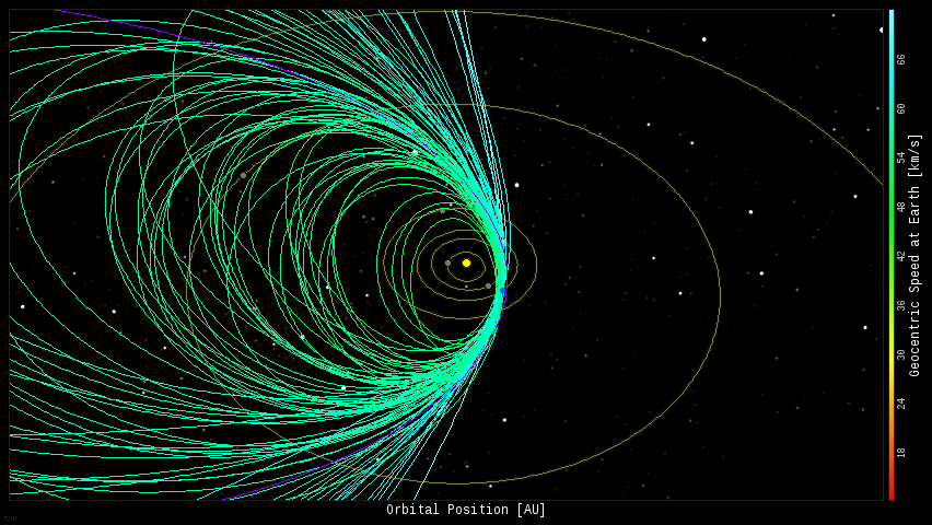
Annual Perseid Meteor Shower Cometh
Every year, the Earth passes through debris from the Comet Swift-Tuttle and according to astronomers, we have already entered that debris field, so keep an eye out for meteors each night through next week. The forecast calls for peak Perseid Meteor showers next week and especially around the middle part of next week when as many as 100+ meteors per hour may be visible!
See more from SpaceWeather.com HERE:
______________________________________
Thanks for checking in and have a great weekend ahead! Don't forget to follow me on Twitter @TNelsonWX

No comments:
Post a Comment