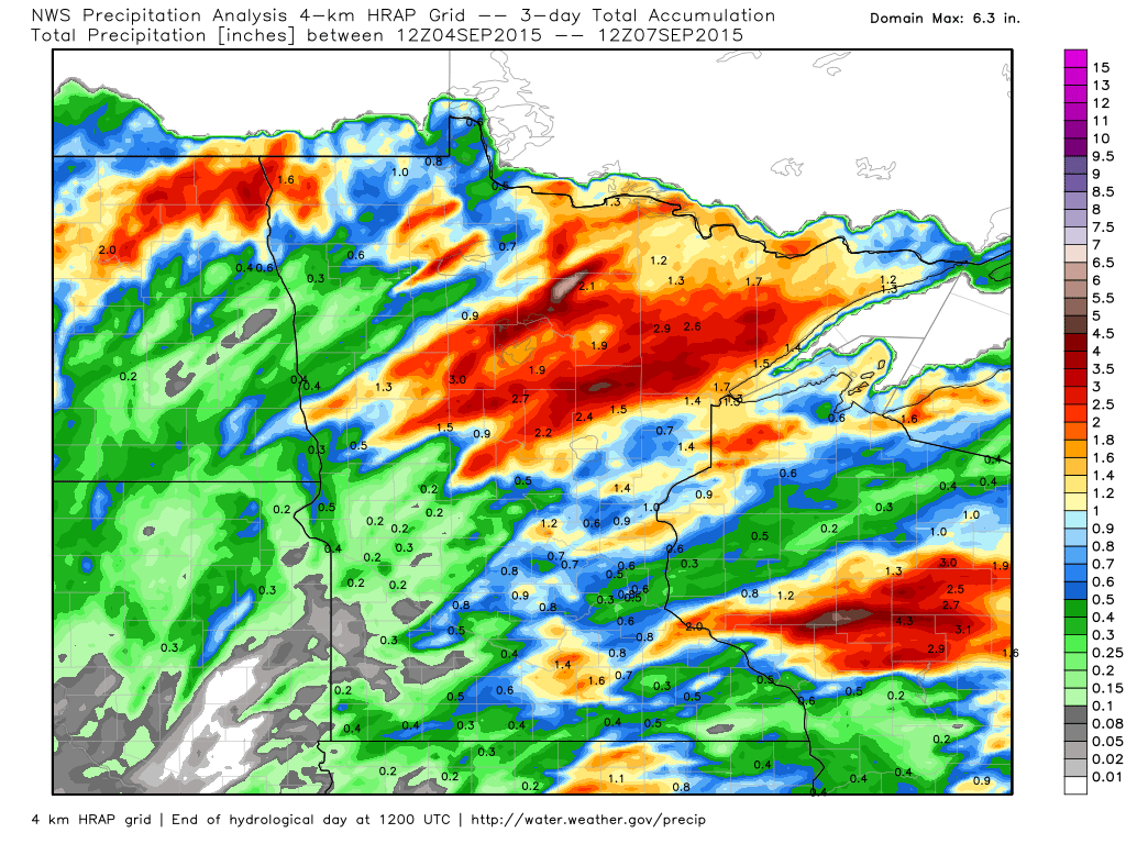
3 Day Radar Estimated Rainfall
The 3 day radar estimated rainfall from AM Friday to AM Monday suggests nearly 1" to 3" fell across parts of northern Minnesota
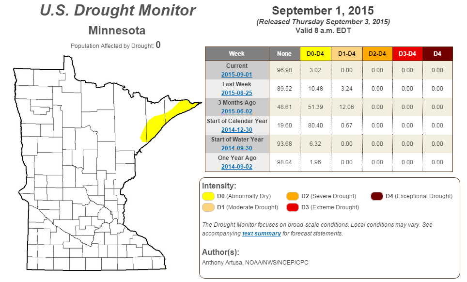
MN Drought Monitor
This is nice to see! According to the U.S. Drought Monitor, only 3% of the state is considered to be abnormally dry. If you think about it, the summer of 2015 really has been pretty spectacular. It hasn't been too hot or humid for too long and we've had adequate rainfall at just the right time to keep most lawns and gardens looking mostly lush.
Back to the grind
By Todd Nelson
It seems surreal that the unofficial end of summer is behind us, doesn't it? I feel like we were just celebrating the 4th of July yesterday. No doubt, time goes too fast. Did I mention that I was going to miss the summer?
I have to admit, I do enjoy the more refreshing breeze through the house around this time of the year. It's hard to replace the crisp autumn air and the smell of fresh apple pie. That means I'll have to make a stop at my Grandma's for some fresh baked goodies.
Keep in mind that the Autumnal Equinox arrives in two weeks. The average high in the Twin Cities on that day is 69 degrees! Yes, changes start happening fast at this time of the year. If you haven't noticed, we've lost nearly 2 hours and 40 minutes of daylight since the Summer Solstice.
Weak impulses of energy will slide through the region this week with a few spotty thundershower chances. It won't be anything significant and we certainly won't have much in the way of rainfall potential, however, you will notice a subtle chill to the air that we haven't felt in a while. It's about that time of the year to find my favorite hoodies, there's a hint of fall in the air.
________________________________
MONDAY NIGHT: Spotty shower or storm possible in southern MN. Low: 62. Winds: NW turning SE 5mph.
TUESDAY: Back to school. Cooler with a spotty shower possible. High: 79.
TUESDAY NIGHT: Mostly clear and quiet. Low: 55. Winds: NW 5-10mph.
WEDNESDAY: Sunny start, rumble possible overnight. High: 76.
THURSDAY:AM shower, cool breeze. Wake-up: 56. High: 70.
FRIDAY: Hello Fall! Clouds thicken late. Wake-up: 53. High: 68.
SATURDAY: AM shower, more PM sun. Wake-up: 51. High: 72.
SUNDAY: Milder sunshine. Wake-up: 58. High: 76.
MONDAY: Slight chance of thunder. Wake-up: 58. High: 77
______________________________
This Day in Weather History
September 8th
1985: An F1 tornado touched down in Faribault County causing $25,000 worth of damage and hail up to 1 3/4 inches in Freeborn and Waseca Counties.
1968: 1 3/4 inch hail fell in Goodhue County.
1931: A record was set in St. Cloud with a temperature of 102 degrees Fahrenheit.
_______________________________
Average High/Low for Minneapolis
September 8th
Average High: 75F (Record: 99F set in 1931)
Average Low: 56F (Record: 36F set in 1883)
________________________________
Sunrise/Sunset Times for Minneapolis
September 8th
Sunrise: 6:43am
Sunset: 7:37pm
*Daylight lost since yesterday: ~3 minutes and 3 seconds
*Daylight lost since summer solstice (June 21st): ~2 hours and 42 minutes
_________________________________
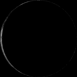
Moon Phase for September 8th at Midnight
3.9 Days After Last Quarter
______________________________________
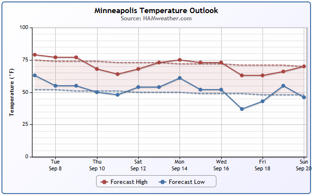
Minneapolis Temperature Trend
Ahh... this is more like it! After several days with highs nearly 10F to 15 F degrees above average, temperatures have cooled to more September-like levels and look to stay there through the next several days. However, not the cooler than average readings that will be with us later this week and potentially again next week. I suspect that some folks my be trading their shorts from this weekend for sweatshirts over the coming days.
__________________________________________
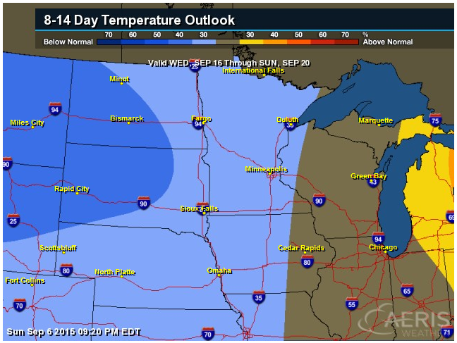
8 to 14 Day Temperature Outlook
According to NOAA's CPC, the 8 to 14 day temperature outlook suggests more cooler weather moving in by next week. No doubt, it'll feel more like fall over the coming days! Also keep in mind that this cooler weather will help to trigger a few more fall colors, especially up north.
___________________________________
Average Fall Color in Minnesota
With cooler weather on the way, keep an eye out for fall colors! According to the MN DNR, typical peak across far northern Minnesota is only a few weeks away, while we're still about one month away from peak near the Twin Cities.

______________________________
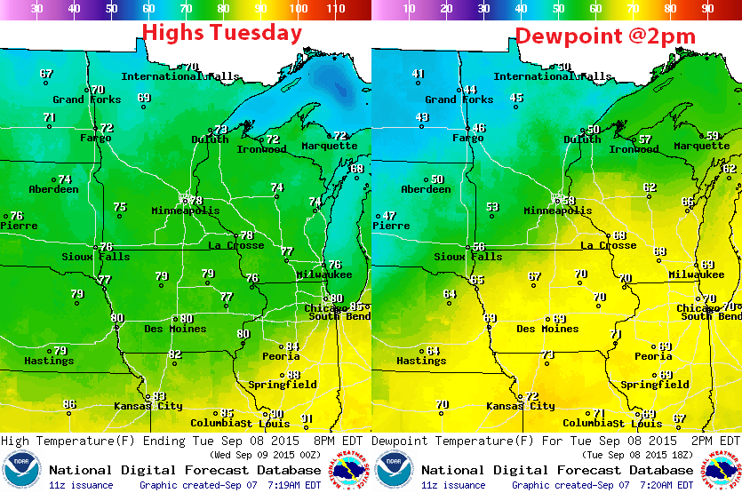
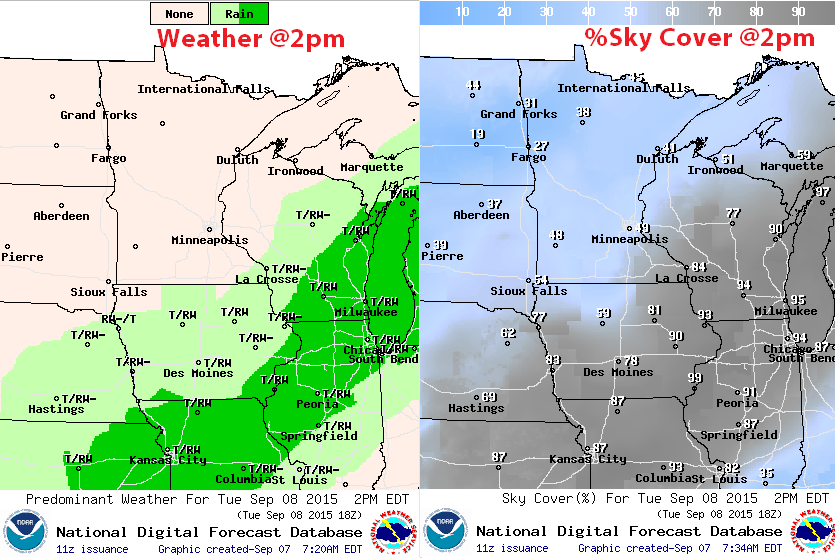
Tuesday Weather Outlook
There will be a hint of fall in the air over the next few days with highs in the 60s and 70s across the region. Note that dewpoints will be significantly lower than they were over the weekend. From a near 70F dewpoint to a near 50F; the 20F dewpoint drop means that have half as much water in the air than we did this weekend!
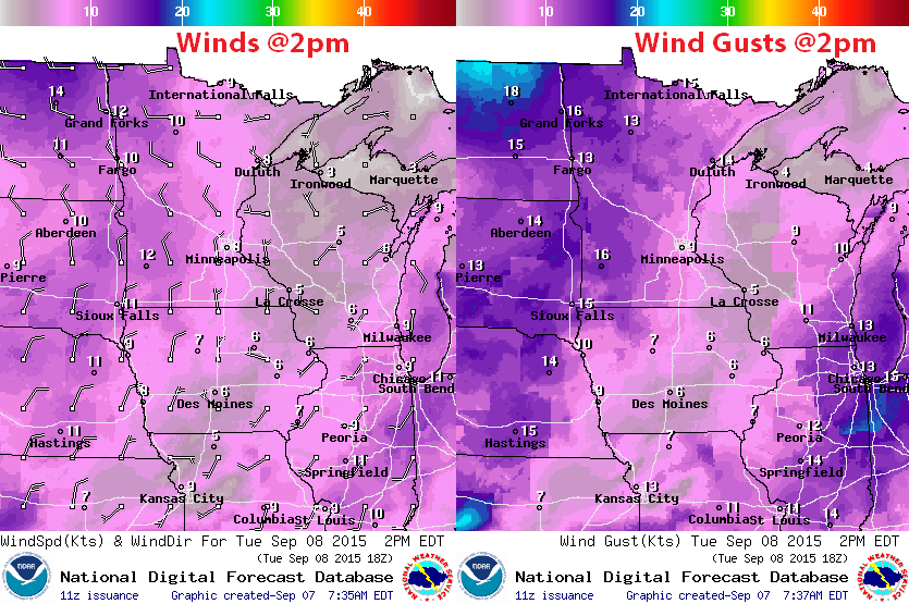
Tuesday Weather Outlook
Winds will be more northwesterly on Tuesday with a few gusts across western/northwestern Minnesota approaching 20mph later in the day. This northwesterly breeze will help to continue to pump in cooler/less humid weather.
Tuesday Weather Outlook
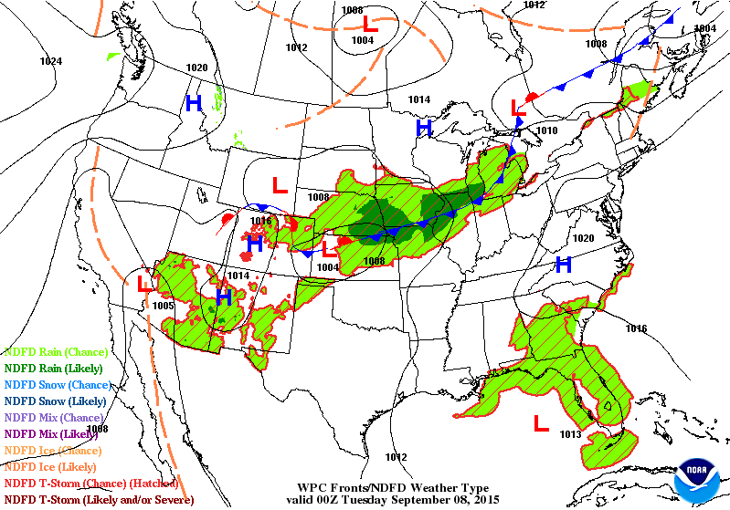
The same front that brought us heavy rain and a few strong storms over the weekend will continue to slowly slide southeast through the middle part of the country/Great Lakes Region. Much of the heavy precipitation will be well south of us now.
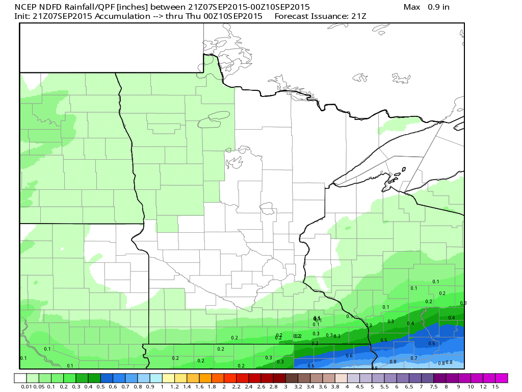
Rainfall Potential
While much of the rain will be south of us over the next day or so, the rainfall potential through PM Wednesday suggests very little precipitation possible across parts of the state as weak impulses of energy scoot through the region through the remainder of the week.
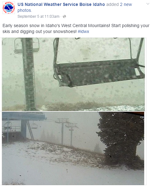
________________________________________Recent Mountain Snows...
Believe it or not, parts of the Northern Rockies recently saw SNOW! Take a look at this post from the National Weather Service out of Boise, Idaho (September 5th). These images from Brundage Mountain Resort in Idaho, where the snow has since melted.
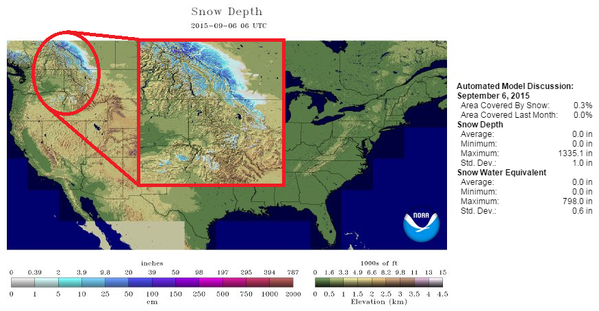
National Snow Depth Map
YIKES!! I am breaking this map out for the first time this season. According to NOAA's NOHRSC, the national snow depth map from September 6th, suggested that 0.3% of the nation was covered in snow. Keep in mind that it was mainly the higher elevations in the Northern Rockies...
National Weather Outlook
The cold front responsible for our somewhat soggy weather over the weekend will continue to push southeast through the next few days with much cooler and less humid weather behind it. However, scattered showers and storms will continue along the eastern edge of the front will locally heavy rain and possibly some strong to severe storms.
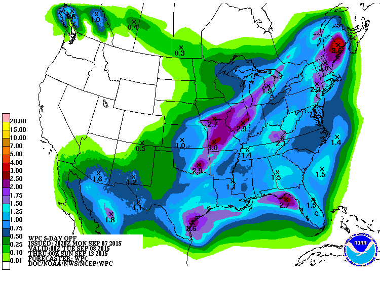
5 Day Precipitation Outlook
According to NOAA's WPC, the heaviest rainfall will be across parts of the Midwest/Great Lakes/Northern New England States through the early week time frame.
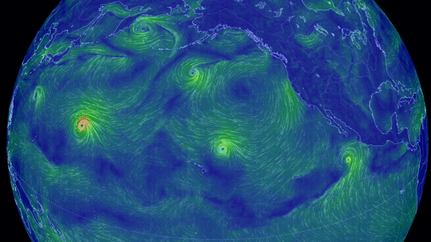
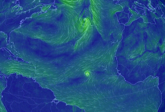
Pacific Update
This was the view of the Pacific on Monday, which showed several areas of circulation. The easternmost area of circulation just southwest of Mexico was newly formed Linda.
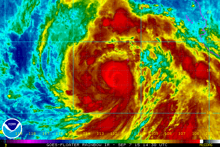
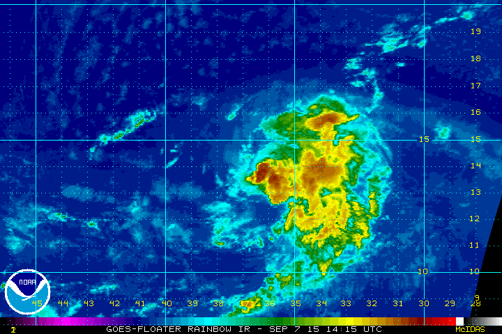
Hurricane Linda
This was the view of Hurricane Linda from PM Monday, which was equivalent to a category 2 storm with winds near 105mph.
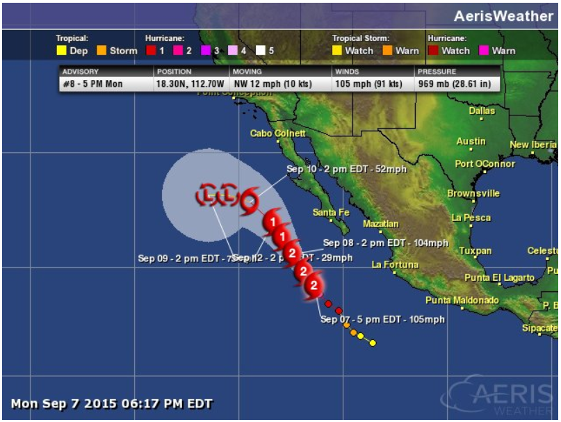
Tracking Linda
This was the official track for Linda, which shows some deterioration by the end of the week.
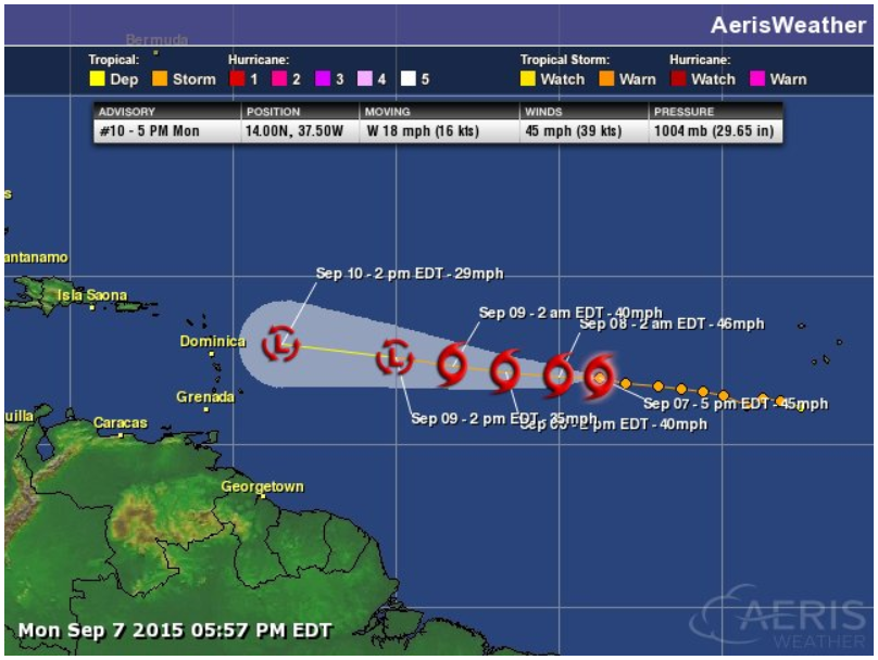
The only storm in the Atlantic basin on Monday was that of Tropical Storm Grace.
Tropical Storm Grace
Tropical Storm Grace looked pretty disorganized on Monday evening.
Tracking Grace
Grace looks to continue tracking west toward the Lesser Antilles
____________________________________________
Thanks for checking in and have a great week ahead! Don't forget to follow me on Twitter @TNelsonWX

No comments:
Post a Comment