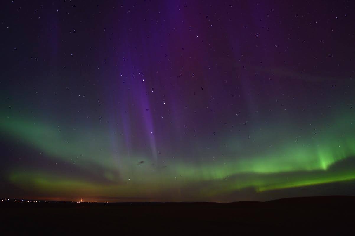
A geomagnetic storm produced a brilliant display of northern lights PM Monday - AM Tuesday. The picture below was taken from a meteorologist at the National Weather Service Bismarck, ND!
See more pictures HERE:
Astro Bob
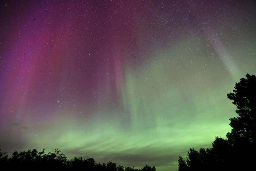
Here's another great shot from my good friend Bob King, a.k.a. Astro Bob. He snapped this picture late Monday night near Duluth, MN.
Check out Astro Bob's page HERE:
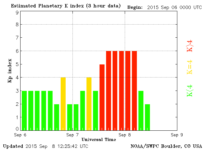
Planetary K-Index
A G2-class geomagnetic storm sent the Planetary K-Index soaring PM Monday - AM Tuesday. This is what the Kp index looked like when it peaked.
See the current Kp Index HERE:
Planetary K-Index
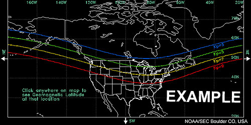
The image below from NOAA's SEC, shows when northern lights may be visible...
Kp of 3: aurora could be expected south to the BLUE line.
Kp of 5: aurora could be expected south to the GREEN line.
Kp of 9: aurora could be expected south to the RED line.
Kp of 9+: aurora could be seen as far south as Texas and Florida.
_____________________________________
Fading into Fall
By Todd Nelson
I couldn't help it, but I actually shed a tear getting my little guy on the bus yesterday. Sometimes it gets tough to see time go by so quickly and for seasons to leave so soon, but we all have to be ready for that next chapter.
Fall won't officially start until the Autumnal Equinox, September 23rd, but it will feel more fall-like this week as temperatures dip to more typical levels. A quick moving impulse of energy will scoot through the region later today with a few spotty showers and storms. Although rainfall won't be all that impressive, this system will help to reinforce the chilly autumn air through the end of the week. Highs in the 60s Thursday and Friday may have you reaching for an extra layer before heading out the door. Overnight lows in the 40s and 50s may also have you reaching for an extra layer at night too.
With that said, the weekend is shaping up to be pretty nice! A little breezy, but nice. At this point, we might be able to sneak up close to 80 degrees again Sunday and perhaps into early next week, but extended models are still suggesting another shot of cooler weather late next week.
What goes up, must come down.
______________________________________
TUESDAY NIGHT: Mostly clear and quiet. Low: 54. Winds: WNW 5mph.
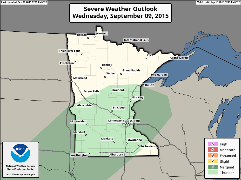
WEDNESDAY: Sunny start, late day rumble risk. High: 77. Winds: WSW 5-10mph
WEDNESDAY NIGHT: Chance of showers and storms. Low: 56. Winds: SW 5-10mph
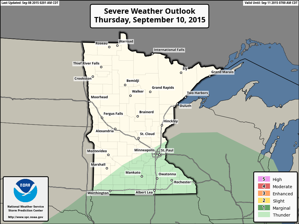
THURSDAY:AM shower, cool PM breeze. High: 70. Winds: Turning NW 5-10mph
FRIDAY:Dry. Risk of a sweatshirt. Wake-up: 50. High: 67.
SATURDAY: Beautiful Fall day! Wake-up: 49. High: 74.
SUNDAY: Warmer wind. Late PM storm. Wake-up: 56. High: 78.
MONDAY: Slight chance of thunder. Wake-up: 60. High: 74
TUESDAY: Breezy. Spotty thunder. Wake-up: 56. High: 78.
_______________________________________
This Day in Weather History
September 9th
1979: 1 3/4 inch hail fell in Douglas County.
1917: Very chilly air over region with 17 degrees at Roseau.
_______________________________________
Average High/Low for Minneapolis
September 9th
Average High: 75F (Record: 95F set in 1947)
Average Low: 56F (Record: 38F set in 1883)
_______________________________________
Sunrise/Sunset Times for Minneapolis
September 9th
Sunrise: 6:44am
Sunset: 7:35pm
*Daylight lost since yesterday: ~3 minutes and 3 seconds
*Daylight lost since Summer Solstice (June 21st): ~2 hours and 45 minutes
________________________________________
Moon Phase for September 9th
3.0 Days Before New Moon
___________________________________________________
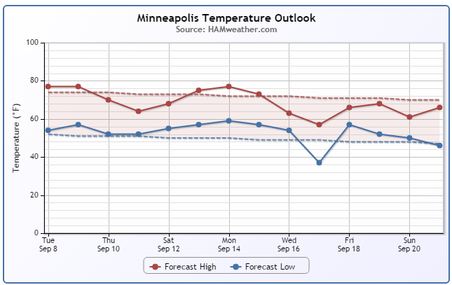
Minneapolis Temperature Trend
After a very summer-like, long holiday weekend, temperatures have finally dropped to more seasonable levels. Interestingly, we're still expecting more cooler to take place later this week to below average levels. There may be a little surge in the temperature department by late weekend/early next week, but there still seems to be guidance suggesting an even bigger cool down by mid month.
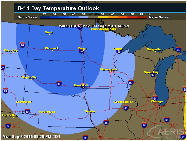
8 to 14 Day Temperature Outlook
According to NOAA's CPC, the 8 to 14 day temperature outlook (September 17th - September 21st) suggests another batch of cooler than average temperatures moving into the Upper Midwest. At this rate, mid to late September will definitely be more fall-like than what we started the month with.
_________________________________________
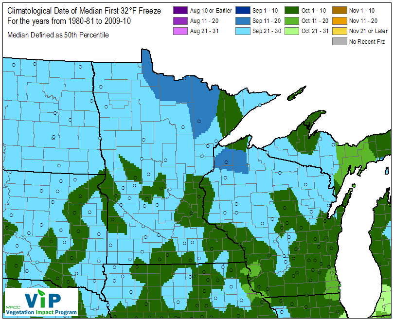
Average First Frost
Thanks to the Midwestern Regional Climate Center for the image below, which shows the average first frost 32° across the region. Note that parts of northern Minnesota typically see a first frost by mid September, while areas near the Twin Cities typically don't see that until closer to mid October.
See more from MRCC HERE:
________________________________________
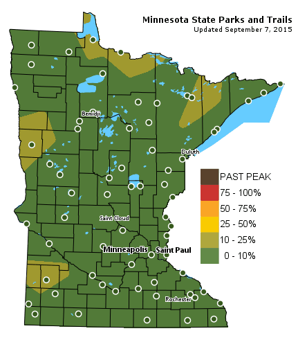
Fall Color Update
Here's the latest update from the MN DNR regarding our fall colors. As of Labor Day, there were a few more areas popping up with 10%-25% fall color, mainly along the international border and in western MN.
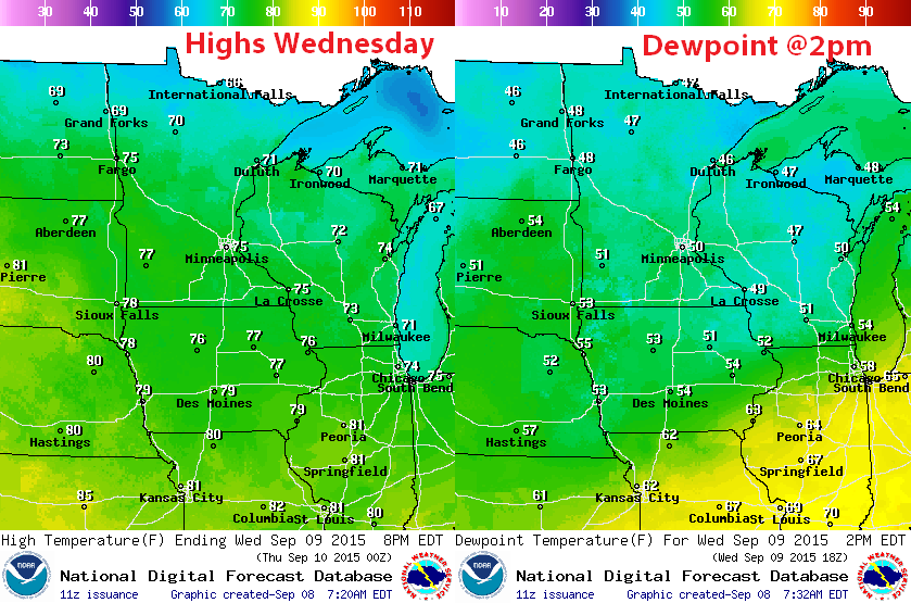
Wednesday Weather Outlook
Wednesday will be another comfortable day with high temperatures in the 60s and 70s and dewpoints in the 40s and 50s across the state. This is far less hot and humid that what we had at the start of September.
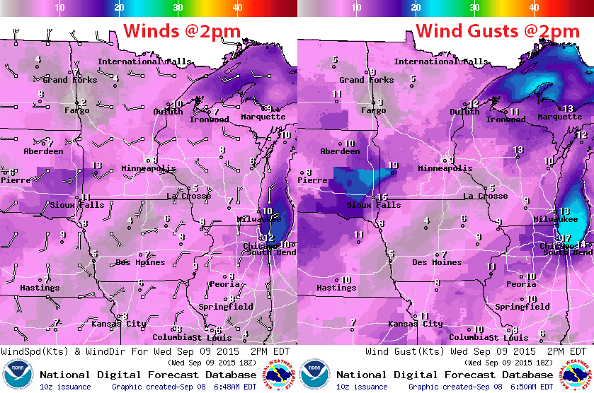
Wednesday Weather Outlook
Westerly winds today around 5-15mph won't be too big of a disruption, but it will help to keep funneling in that cooler/less humid weather from Canada.
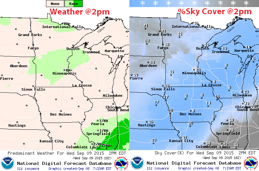
Wednesday Weather Outlook
Wednesday will start on a sunny note, but will become cloudier through the day with a few spotty showers and storms possibly developing later.
Thunder Threat Wednesday
Thunder Threat Thursday
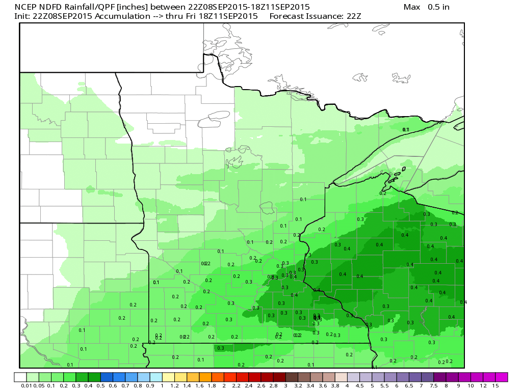
Rainfall Potential
Rainfall since last Friday was fairly impressive across parts of the state/region with the last batch of heavy rain wrapping up early Tuesday morning across southern Minnesota and Wisconsin. Additional rainfall potential through the rest of the week should be fairly light, with the next best chance moving in later Wednesday through early Thursday.
_____________________________________
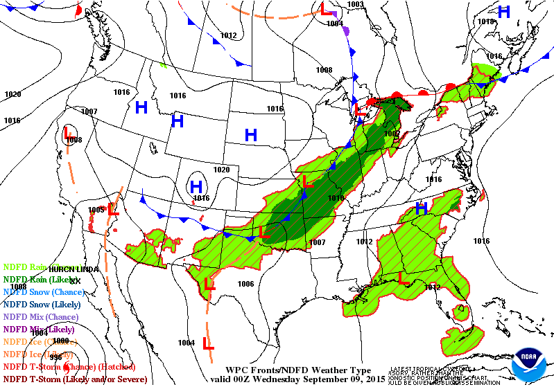
National Weather Outlook
The same front responsible for our fairly soggy Labor Day Weekend is continue to pump out heavy rainfall potential in the eastern half/third of the nation through the middle/end of the week. Note that weather conditions post front are rather quiet across much of the rest of the nation except for the next weaker cold front that moves through the Midwest later this week.
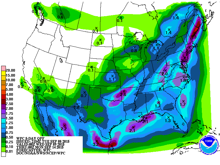
5 Day Precipitation Outlook
According to NOAA's WPC, the 5 day rainfall forecast suggests heavy rain still possible across parts of the eastern half of the country. Also, moisture across parts of extreme southern California and the Desert Southwest is actually moving in thanks to Hurricane Linda in the Eastern Pacific.
_______________________________________
Hurricane Linda
As of PM Tuesday, Linda was still a category 3 hurricane with winds near 125mph. There was a fairly defined eye as well as the storm tracked northwest away from Baja California.
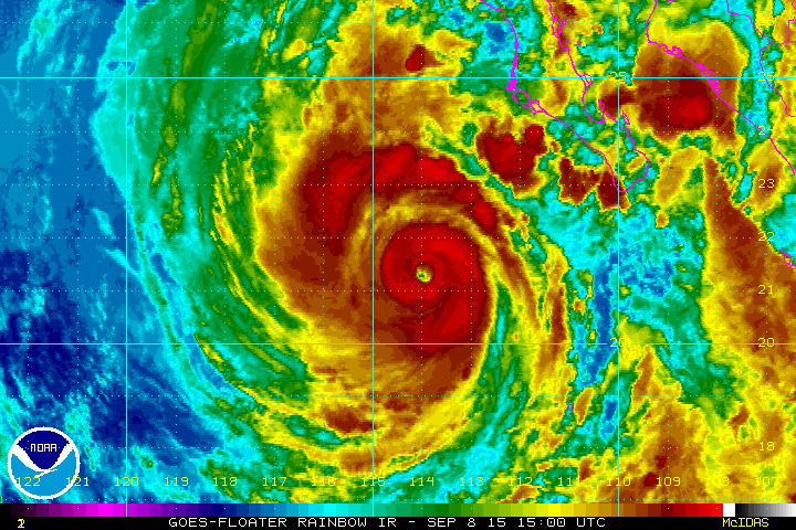
Tracking Linda
The forecast track has Linda weakening over the coming days as it continues tracking west/northwest away from Baja California.

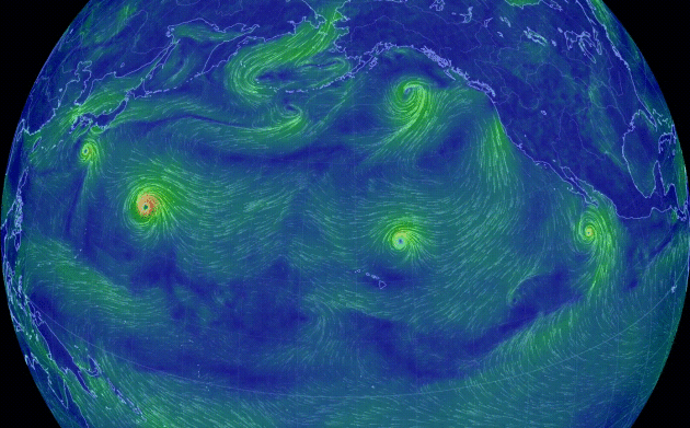
Pacific Update
The wind circulation loop below shows several tropical system in the Pacific Basin. Note Hurricane Linda southwest of of Mexico, while Jimena continues just north of the Hawaiian Islands as well as Kilo and Euta in the Western Pacific. Also note the remnants of Ignacio in the Gulf of Alaska. Interestingly, these remnants are on track to affect parts of southeast Alaska and Canada!
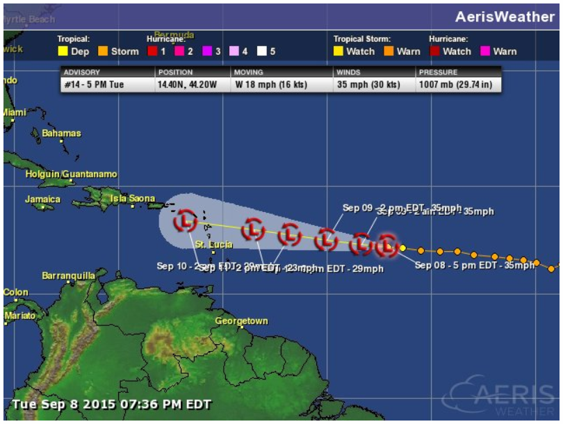
Atlantic Update
As we head closer to the peak of the Atlantic Hurricane Season (September 10th), the only system even relevant in the Atlantic Basin is that of Grace
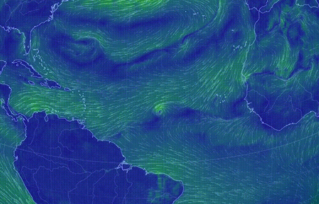
Grace Continues in the Atlantic
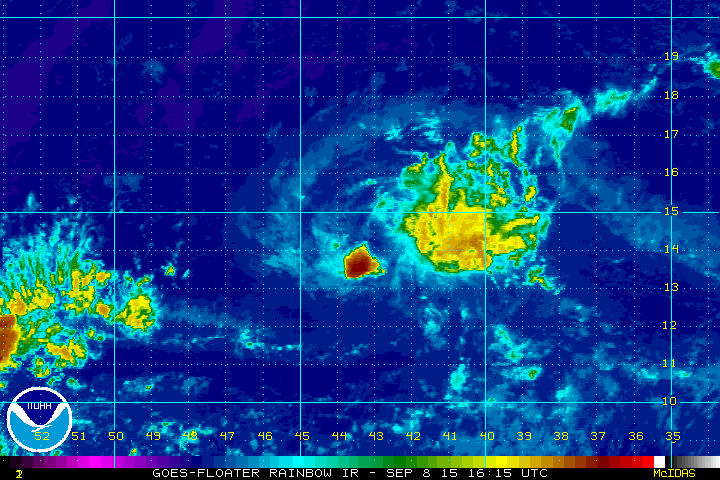
Tracking Grace
Dry air and unfavorable weather conditions have Grace floundering in the Atlantic Basin over the next several days.
_____________________________________
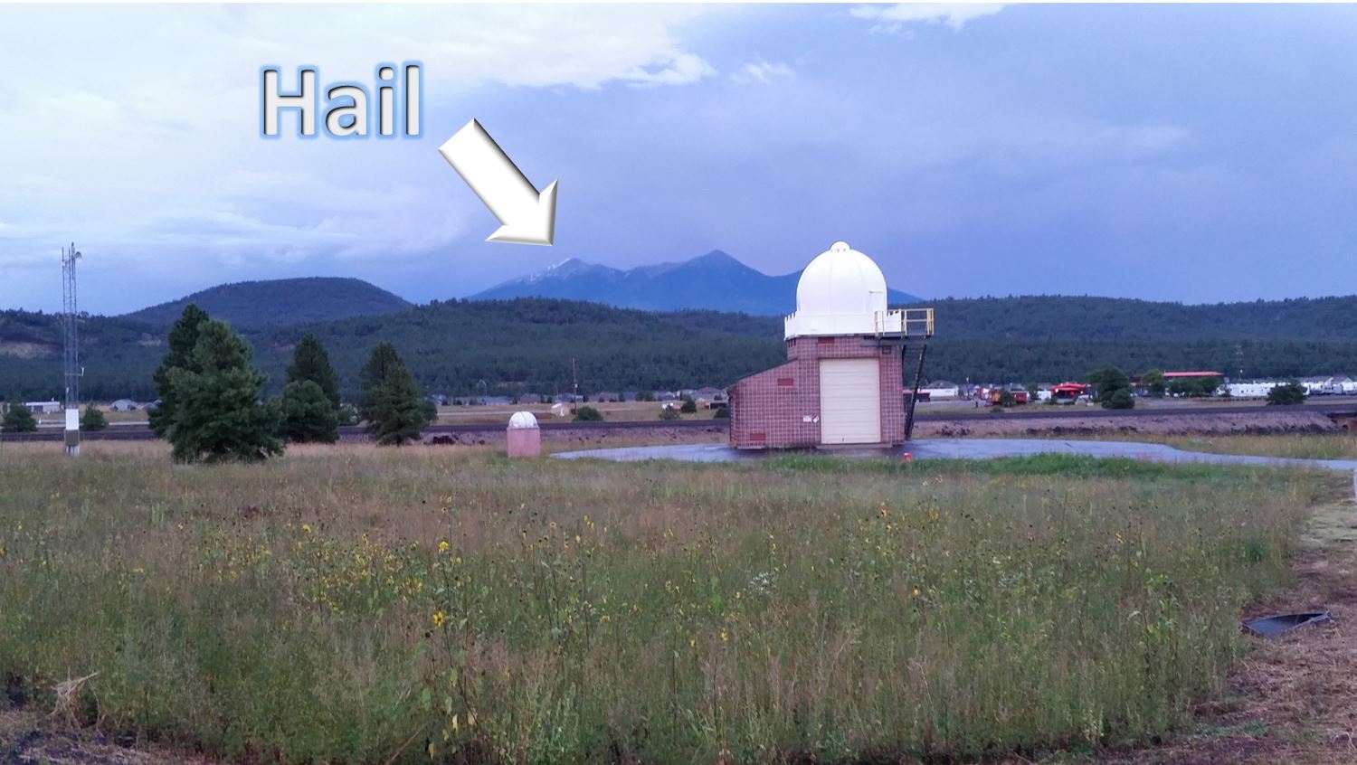
Arizona Hail
Here's a neat picture from the National Weather Service out of Flagstaff, AZ. A double take may had folks thinking they saw snow on top of Mt. Humphreys when in fact it was hail from a recent thunderstorm on Labor Day Monday!
If you glanced up at the San Francisco peaks this evening you may have thought you saw snow! Storms that rolled through just before 6 pm left a lot of hail on the west facing slope of Mt. Humphreys.
See more from the National Weather Service out of Flagstaff, Arizona HERE:
_______________________________
Thanks for checking in and have a great rest of your week! Don't forget to follow me on Twitter @TNelsonWX

No comments:
Post a Comment