I love this picture! Thanks to my good friend Kirsten Monshaugen Hage and her daughter who must have had a very enjoyable summer! While some kids have already gone back to school, everybody will be back in session on Tuesday. Summer is coming to an end...

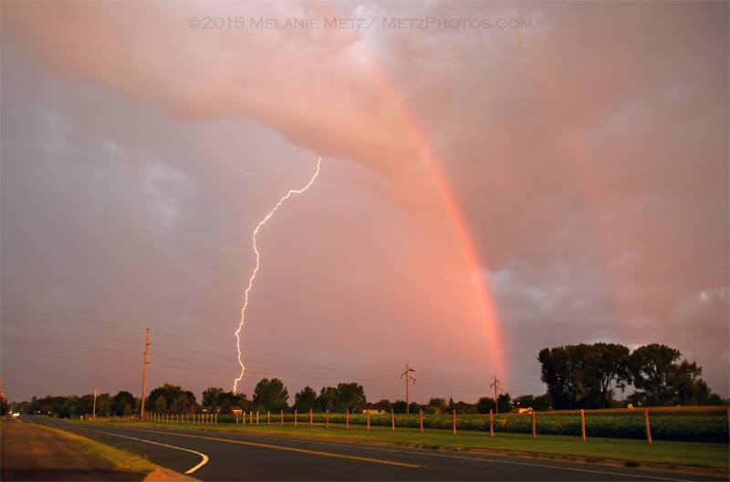
Saturday Morning Storms
WOW! Great picture from my good friend and very talented photographer Melanie Lorraine Metz. She snapped this amazing picture Saturday morning from Otsego, MN. Thanks Melanie!
"This gorgeous display of nature was worth getting out of bed at 6:30 Saturday morning! After shooting the incredible sunrise from across the street, I grabbed one last shot of the approaching storm as I ran back to the house. And this was the lucky shot of the day! Handheld. 9/05/15 in Otsego, MN."
(Image courtesy Melanie Lorraine Metz / MetzPhotos.com)
No Regrets
By Todd Nelson
I am saddened to hear that one of my all-time favorite inspirational speakers, Dr. Wayne Dyer, recently passed. He wrote: "Live this day as if it were your last. The past is over and gone. The future is not guaranteed."
I have a 6 year and a soon to be 4 year old at home. Sure, life gets hectic once in a while, but I try to remember the little things. One of my only rules in the house is, no growing up, I hope they obey.
Make the most of the summer weather while you can. The chance of temperatures like what we're experiencing now will decrease exponentially as we head through the next several weeks. For those of you that like the cooler, less humid weather, you're in luck too! A series of cold fronts will help temperature and humidity values to dip to more fall-like levels later this week.
The first front will swing through today with scattered showers and storms, some of which could be strong to severe with gusty winds and locally heavy rain. Keep an eye on the weather later today. In the meantime, we'll still be sweating out another summery September day with feels like temps near 90 degrees.
I suspect sweatshirts will replace shorts later this week.
_____________________________
SATURDAY NIGHT: Scattered showers and storms. Low: 75. Winds: S 10-15mph
SUNDAY: Warm and breezy. Strong storm possible late. High: 86. Winds: S 15-25mph
SUNDAY NIGHT: Scattered showers and storms early, then turning partly cloudy. Low: 62. Winds: SW turning WNW 5-15mph
LABOR DAY: Not as hot, sun fades late. High: 80. Winds: WNW 5-10mph
TUESDAY: Back to school. Rumble early, pleasant afternoon. Wake-up: 60. High: 78.
WEDNESDAY: Comfy. Storms possible overnight. Wake-up: 56. High: 76.
THURSDAY:Slight chance of thunder. Wake-up: 57. High: 71.
FRIDAY: Hello Fall! Chilly breeze. Wake-up: 52. High: 67.
SATURDAY: Brisk sun, nothing rought. Wake-up: 51. High: 70.
_____________________________
This Day in Weather History
September 6th
1977: An early morning thunderstorm dropped 2 inch hail in McLeod County.
1922: Heat wave over Minnesota with highs over 100 in southwest Minnesota. One of the hot spots was New Ulm with 105.
______________________________
Average High/Low for Minneapolis
September 6th
Average High: 76F (Record: 98F set in 1922)
Average Low: 66F (Record: 35F set in 1885)
______________________________
Sunrise/Sunset Times for Minneapois
September 6th
Sunrise: 6:41am
Sunset: 7:41pm
*Daylight lost since yesterday: ~3 minutes and 2 seconds
*Daylight lost since summer solstice (June 21st): ~2 hours and 36 minutes
_______________________________
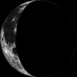
Moon Phase for September 6th at Midnight
1.9 Days After Last Quarter
______________________________
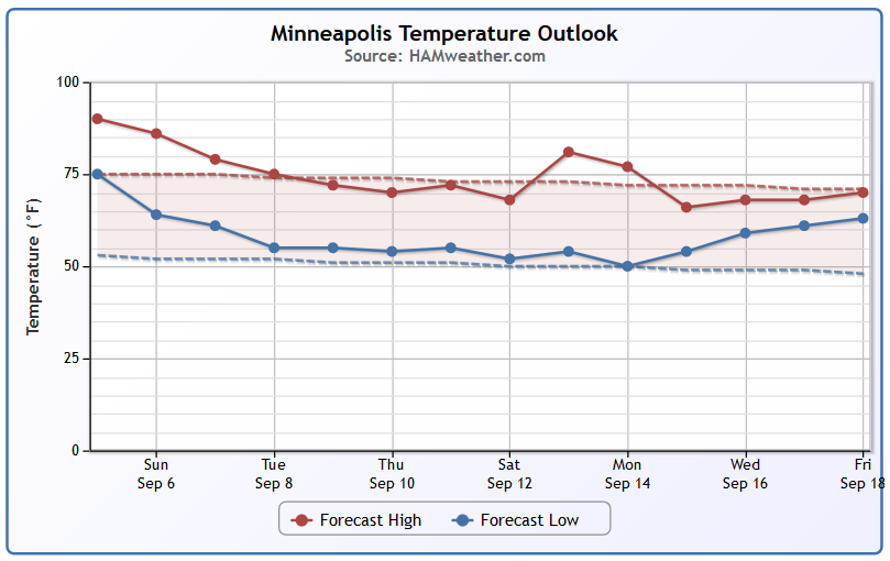
Minneapolis Temperature Trend
We're nearing the end of our September warm spell. Note that as we head into next week, temperatures will cool to near normal levels once again.
____________________________
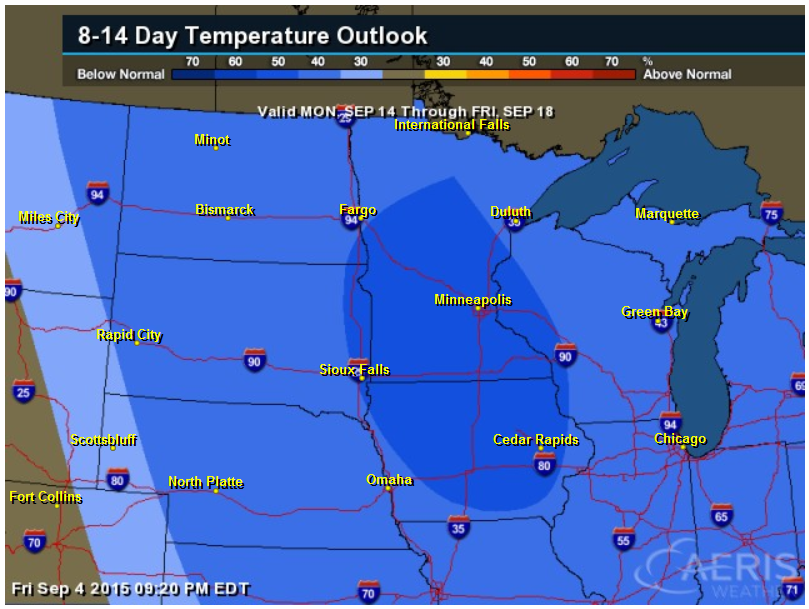
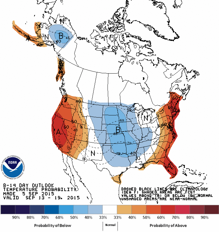
8 to 14 Day Temperature Outlook
According to NOAA's CPC, the 8 to 14 day temperature outlook suggests the potential of much cooler than average temperatures as we approach the middle part of September.
___________________________________
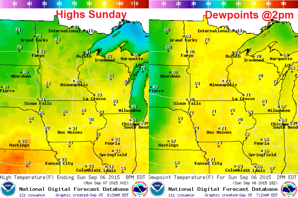
Sunday Weather Outlook
Sunday will be our last hot day across the Upper Mississippi Valley. Temperatures will still be in the 80s with dewpoints in the upper 60s and lower 70s, which means that feels like temperatures will be in the lower 90s.
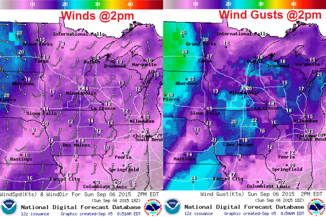
Sunday Weather Outlook
South winds on Sunday will be breezy with gusts close to 25mph at times.
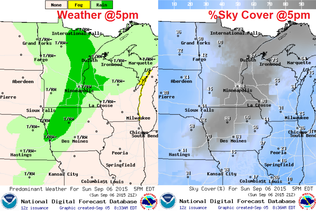
Sunday Weather Outlook
Scattered showers and storms are expected to develop during the afternoon/evening hours, some of which could be strong to severe with gusty winds and locally heavy rain.
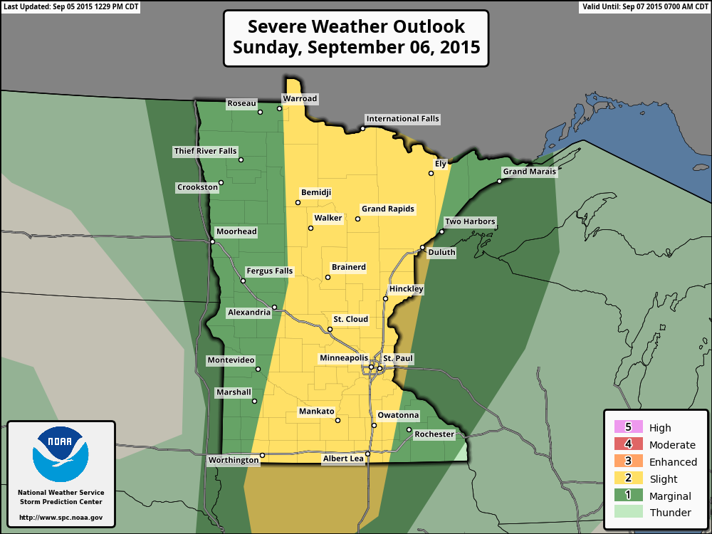
Severe Threat Sunday
...SUMMARY... A FEW SEVERE THUNDERSTORMS ARE EXPECTED TO DEVELOP OVER PARTS OF MINNESOTA SUNDAY AFTERNOON AND EVENING. OTHER STRONG TO ISOLATED SEVERE THUNDERSTORMS MAY DEVELOP SOUTHWARD INTO WESTERN IOWA AND EASTERN NEBRASKA. ...SYNOPSIS... MODEL GUIDANCE INDICATES THE UPPER FLOW PATTERN WILL GRADUALLY DEAMPLIFY ON SUNDAY AS THE UPPER LOW CURRENTLY OVER THE PACIFIC NW MOVES NEWD INTO SRN SASKATCHEWAN...AND HEIGHTS FALL FROM THE NRN ROCKIES/PLAINS TOWARD THE UPPER MS VALLEY. AT THE SURFACE...A COLD FRONT OVER THE DAKOTAS AND WRN NEB AT THE START OF THE PERIOD IS FORECAST TO PROGRESS EWD/SEWD REACHING FROM WRN MN INTO ERN NEB BY 07/00Z AND CONTINUING TO WRN PARTS OF LAKE SUPERIOR AND WI SWWD ACROSS CENTRAL IA INTO SWRN KS BY 07/12Z. THE FRONT IS EXPECTED TO PROVIDE A FOCUS FOR STRONG/SEVERE THUNDERSTORM DEVELOPMENT MAINLY DURING THE LATE AFTERNOON AND EVENING.
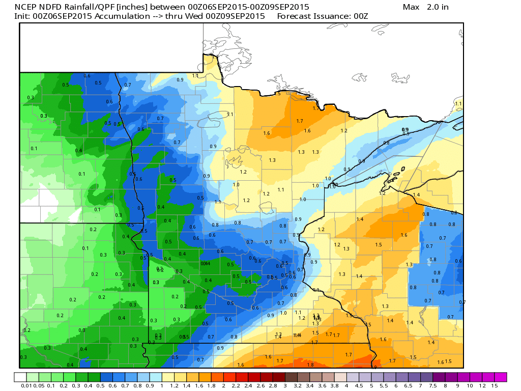
Rainfall Potential
Another round of showers and storms will develop late Sunday with heavy pockets across parts of the region. The rainfall potential through early next week suggests as much as 1" to nearly 2" possible, especially in northern Minnesota.
______________________________________
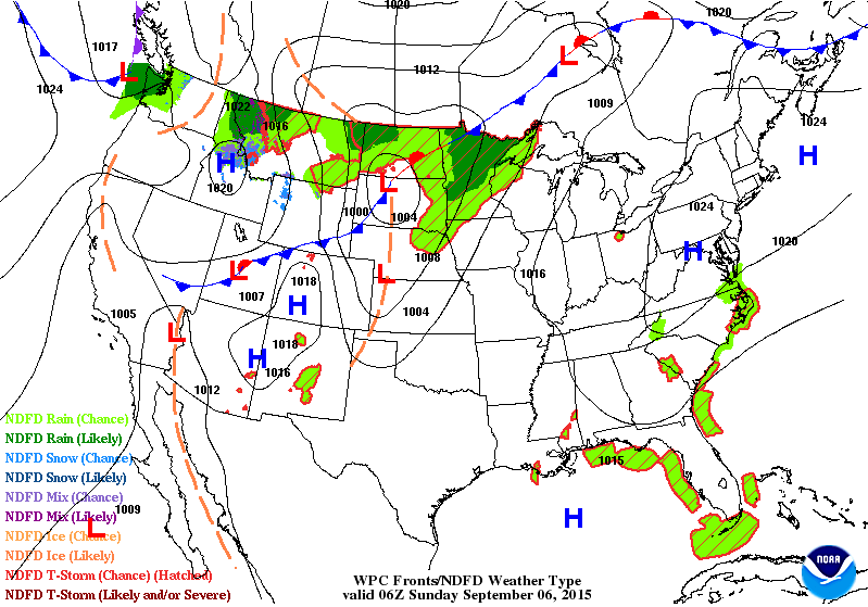
National Weather Outlook
The storm system moving across the northern tier of the nation will be responsible for widely scattered showers and storms across the Upper Midwest on Sunday. Lingering showers and storms will move into the Great Lakes Region by Monday with cooler temperatures in it's wake.
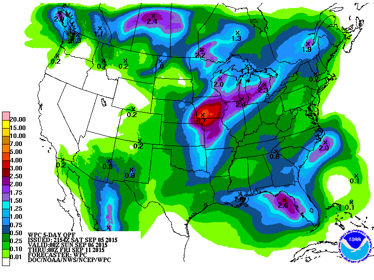
5 Day Precipitation Outlook
According to NOAA's WPC, the 5 day precipitation outlook shows heavy rainfall potential across the middle part of the country through the middle part of next week. Note that Florida is still expected to see some heavier rainfall potential as well.
____________________________________
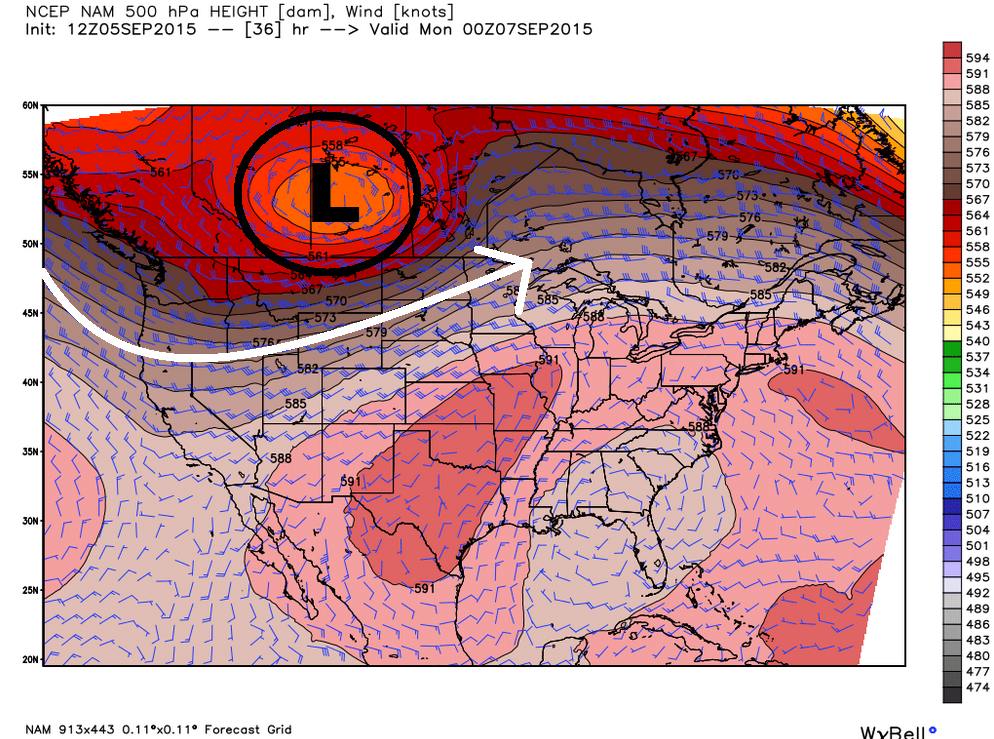
Upper Level Storm
The upper level storm that we've been following in the Western U.S. over the past few days will begin lifting north into Canada late weekend/early next week. This will be responsible for slightly cooler temps near the international border as we head into the early week time frame.
__________________________________-
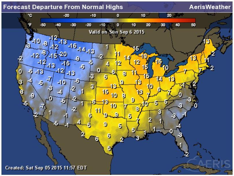
Highs From Average Sunday
The image below suggests Sunday's highs from average. Note that temperatures in the eastern two-thirds of the nation will still be warmer than average, while cooler than average readings are staring to spread farther east. Temperatures by the middle of the week will be closer to average for many locations nationwide.
Extended Temperature Outlook
According to NOAA's CPC, the 8 to 14 day temperature outlook suggests still cooler than average readings in the middle part of the country, while areas along the east and west coast will be warmer than average by mid month.
___________________________________
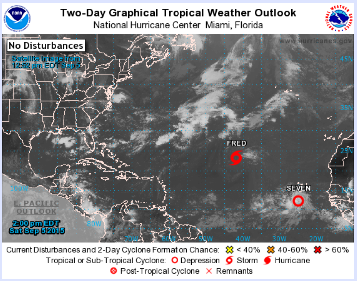
Atlantic Update
As of Saturday, there 2 tropical systems in the Atlantic Basin. Fred and newly formed Tropical Depression Seven
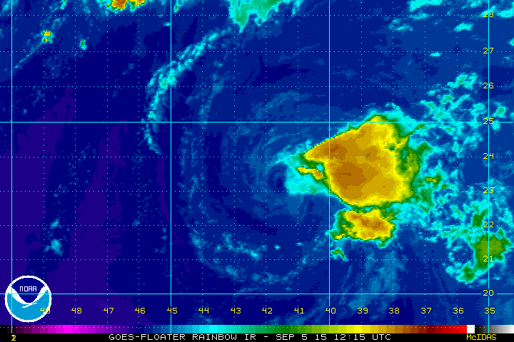
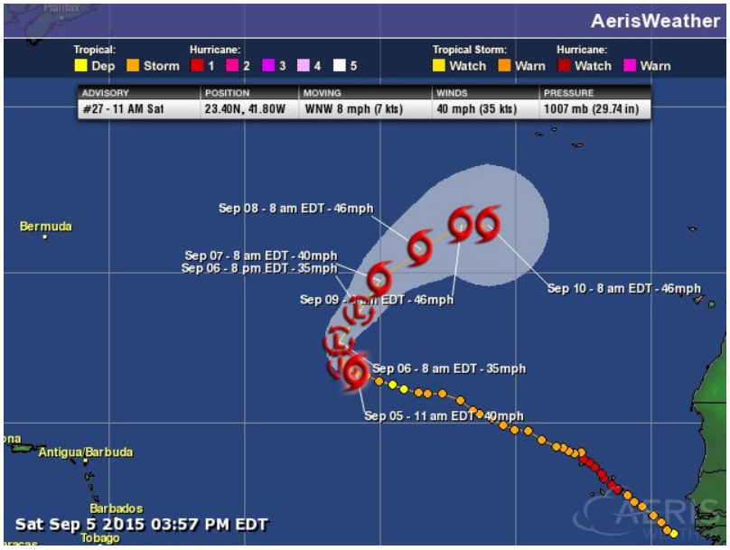
Tropical Storm Fred
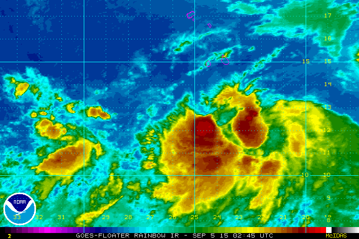
This is kind of an interesting satellite loop... Note the void of vibrant colors surrounding the center of circulation. It appears that the entire complex fo thunderstorms surrounding the center of circulation just blew away.
Tracking Fred
Fred has been a interesting storm. Wobbling around the Atlantic, it became our 2nd hurricane of the season and quickly diminished. The track takes it to tropical depression strength and then tropical storm strength again later this week.
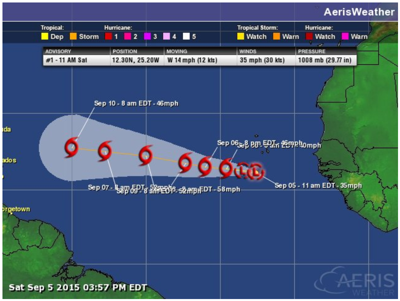
Tropical Depression Seven
This was newly developed Tropical Depression Severn as of Saturday afternoon (CDT). TD Seven is forecast to become our 7th named storm of the season.
Tropical Depression Seven Track
Here's the forecast track, which calls for Tropical Storm Strength by later this weekend. Likely Grace.
___________________________________
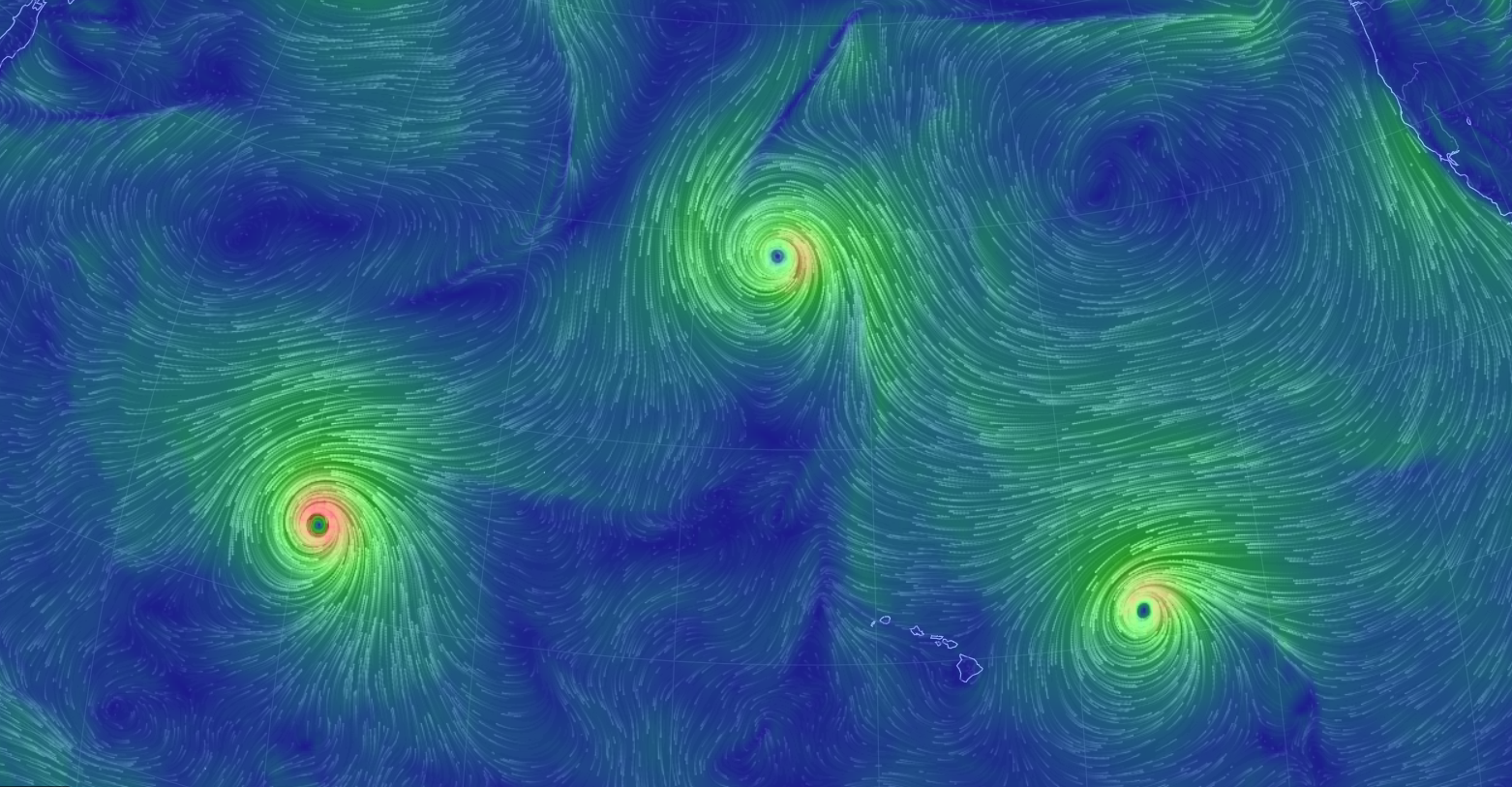
Active in the Pacific
Thanks the Earth.NullSchool for the image below, which shows three topical systems in play in the Pacific. From left to right; Kilo, Ignacio and Jimena
_________________________________________
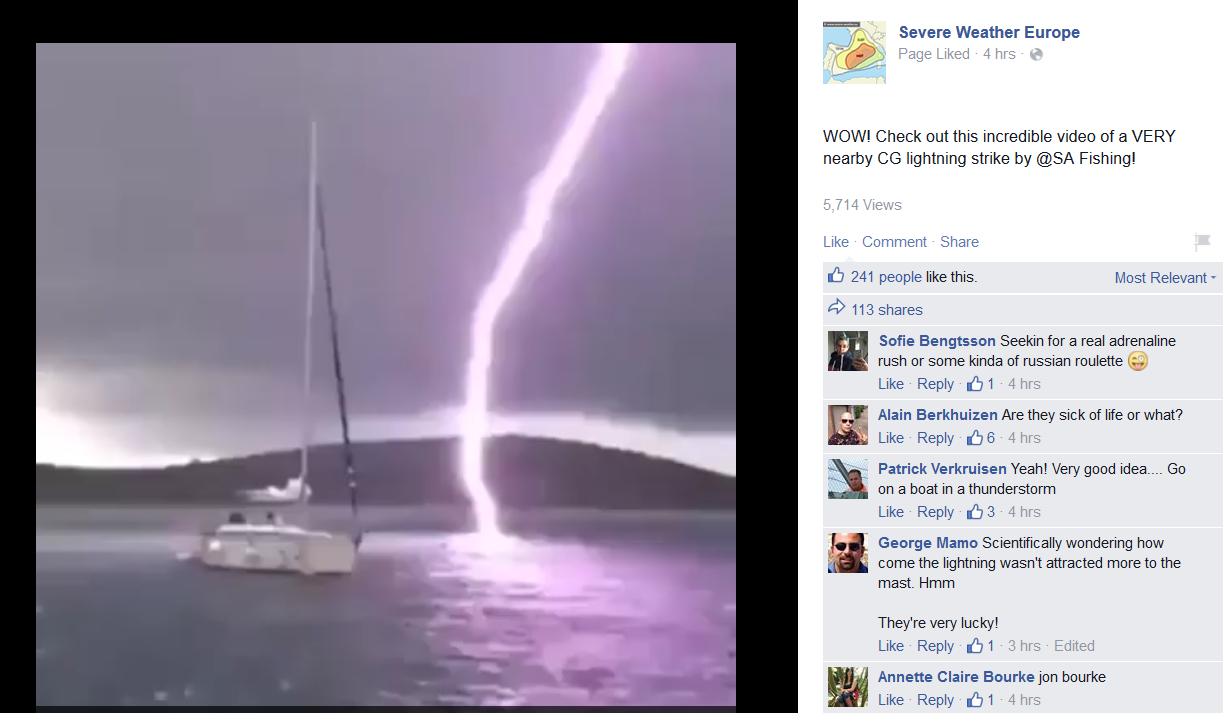
A Close Call...
Take a look at this incredible video from the Severe Weather Europe Facebook Page. Talk about a close call... YIKES!
See the video HERE:
____________________________________
"Virtual twister reveals possible source of tornado longevity"
Here's a neat story from ScienceNews.org about a tornado simulation that may help explain why some tornadoes linger for hours after forming.
(CYBER STORM The 60-kilometer-wide swirling thunderstorm in this simulation spawned the first digitally created long-lived EF5 tornado (bottom, right-center). The 700-meter-wide virtual twister may reveal why some real-life tornadoes linger.)
See the full story from ScienceNews.org HERE:

_____________________________________________
Thanks for checking in and have a great rest of your weekend. Don't forget to follow me on Twitter @TNelsonWX

No comments:
Post a Comment