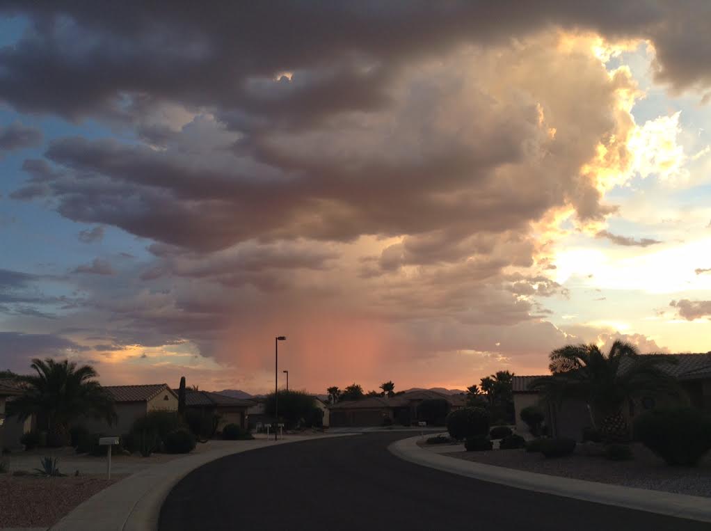
Thanks to Randy Musil for this beautiful picture out of Surprise, AZ as a few monsoonal showers and storms were present in the evening sky a few nights ago. Great picture!
Summer's last gasp?
By Todd Nelson
I have to admit, I love summer. Don't get me wrong, the heat and humidity can get to any person, but it's nice to be able to walk outside and not have to be bundled up like Ralphie's brother, Randy, in the movie "A Christmas Story".
Shade and A/C is a person's best friend on a day like today. Suddenly, shaved ice or ice cold lemonade sounds more refreshing than a pork chop on a stick, doesn't it? Oh, don't worry, I'll still likely stuff my face with all my favorites at the Fair. It's a must! I only do it once a year.
Our sweaty September weather continues through the weekend with feels like temperatures in the low to mid 90s. Dewpoints near 70 degrees will have you glistening even after a fresh shower. Enjoy it while you can (if you like this stuff) because fall-like weather is on the way next week!
A large trough of low pressure will slowly slide our way through the weekend, increasing thunder chances each day. Best chance of storms will be in far northwestern MN late Friday but that thunder risk increases for everybody PM Saturday and Sunday. A few strong storms and locally heavy downpours will remind you of mid summer.
___________________________
THURSDAY NIGHT: Mostly clear, warm and sticky. Low: 71. Winds: ESE 5-10mph
FRIDAY: Hello July! Hot and sticky. High: 89. Winds: SE 10-15 mph
FRIDAY NIGHT: Mostly cloudy. Low: 72. Winds: SSE 5-10mph
SATURDAY: Find some A/C. PM storms, mainly northern MN. Feels Like: 95F. High: 80. Winds: S 10-15 mph.
SUNDAY: Last hot day. Strong storm possible late. Wake-up: 72. High: 86
LABOR DAY: Soggy AM, fresh PM breeze. Wake-up: 64. High: 79
TUESDAY: Back to school. Cooler start, PM thunder south. Wake-up: 58. High: 76.
WEDNESDAY: Clearing and cooler. Wake-up: 57. High: 72.
THURSDAY: More sun. Wake-up: 53. High: 70.
____________________________
This Day in Weather History
September 4th
1992: Early morning storms resulted in 3/4 to 1 3/4 inch hail in Hennepin, Dakota, Rice and Goodhue Counties.
1941: A late batch of tornadoes hit Minneapolis, New Brighton, and White Bear Lake, killing six people.
1925: The third consecutive day of 95 degrees or above in the Minneapolis area.
_____________________________
Average High/Low for Minneapolis
September 4th
Average High: 76F (Record: 98F set in 1925)
Average Low: 58F (Record: 39F set in 1974)
______________________________
Sunrise/Sunset Times for Minneapolis
September 4th
Sunrise: 6:38am
Sunset: 7:45pm
*Daylight lost since yesterday: ~3 minutes and 1 second
*Daylight lost since summer solstice (June 21st): ~2 hours and 30 minutes
_______________________________
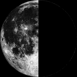
Moon Phase for September 4th at Midnight
0.1 Day Before Last Quarter
__________________________________
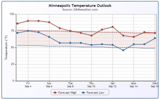
Minneapolis Temperature Trend
Sweaty September weather continues through the weekend with highs still well above average on the high and low side. High dewpoints will make it feel more like the low/mid 90s through Sunday before a cold front pushes through with possibly strong thunderstorms. Note the cooler weather post-front next week. The first FULL week of September will feel more like fall.
_____________________________________
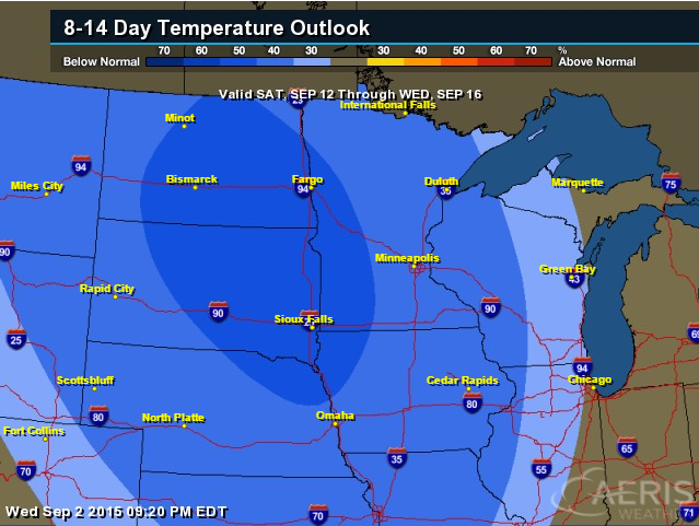
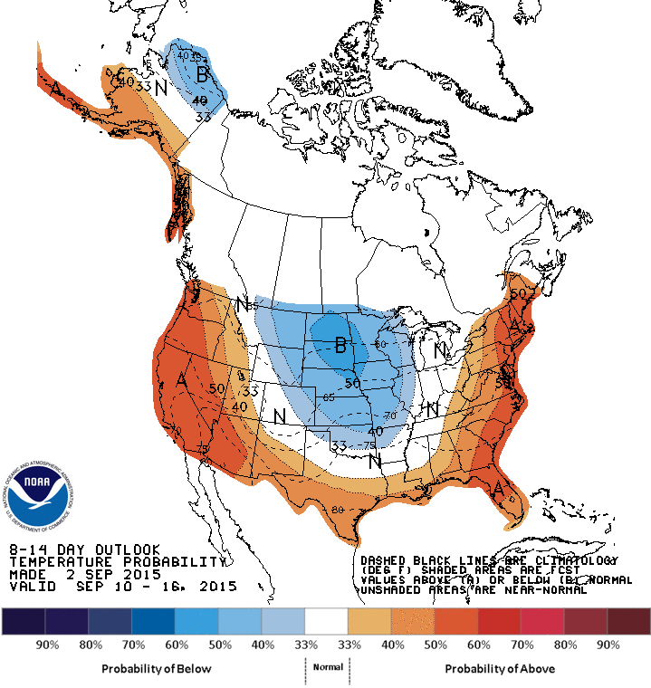
8 to 14 Day Temperature Outlook
According to NOAA's CPC, the 8 to 14 day temperature outlook suggests that much of the Upper Midwest will have cooler than average temperatures by midmonth. For those of you that like the hot, sticky weather now, enjoy it because it'll likely feel like fall in a few short days!
_______________________________________
Friday Weather Outlook
Friday will, no doubt, be a very warm day for September. Highs will approach 90F with dewpoints in the upper 60s and lower 70s, it'll feel more like the low to mid 90s! Find some A/C!!
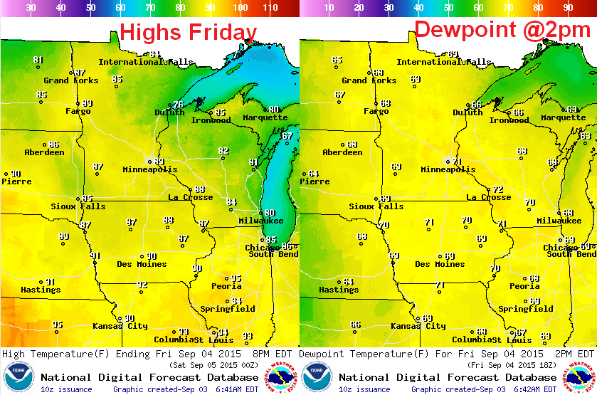
Friday Weather Outlook
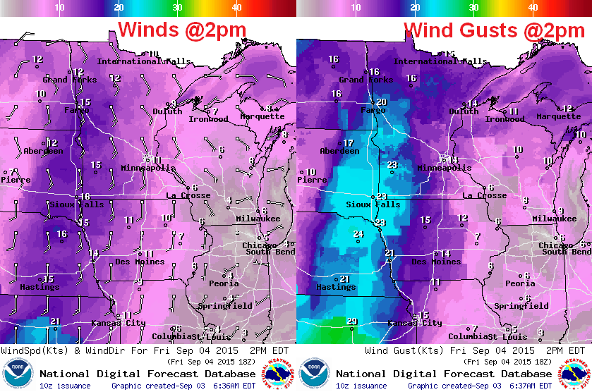
Wind conditions on Friday will also be a bit breezy, especially across western Minnesota and the Dakotas. Note that wind gusts there could be near 20mph+. The reason for the gusty winds is the approaching storm system, which will keep us hot, sticky and somewhat unsettled through the weekend.
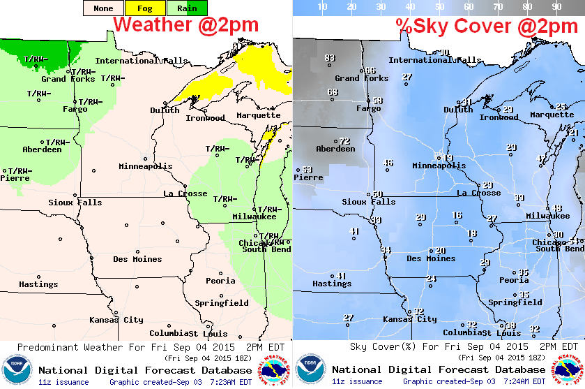
Friday Weather Outlook
The first round of thunderstorms will push into far northwestern Minnesota late Friday with a few strong/severe storms possible and potential even some locally heavy rain. Much of the rest of the state will remain dry, hot and humid.
_______________________________________
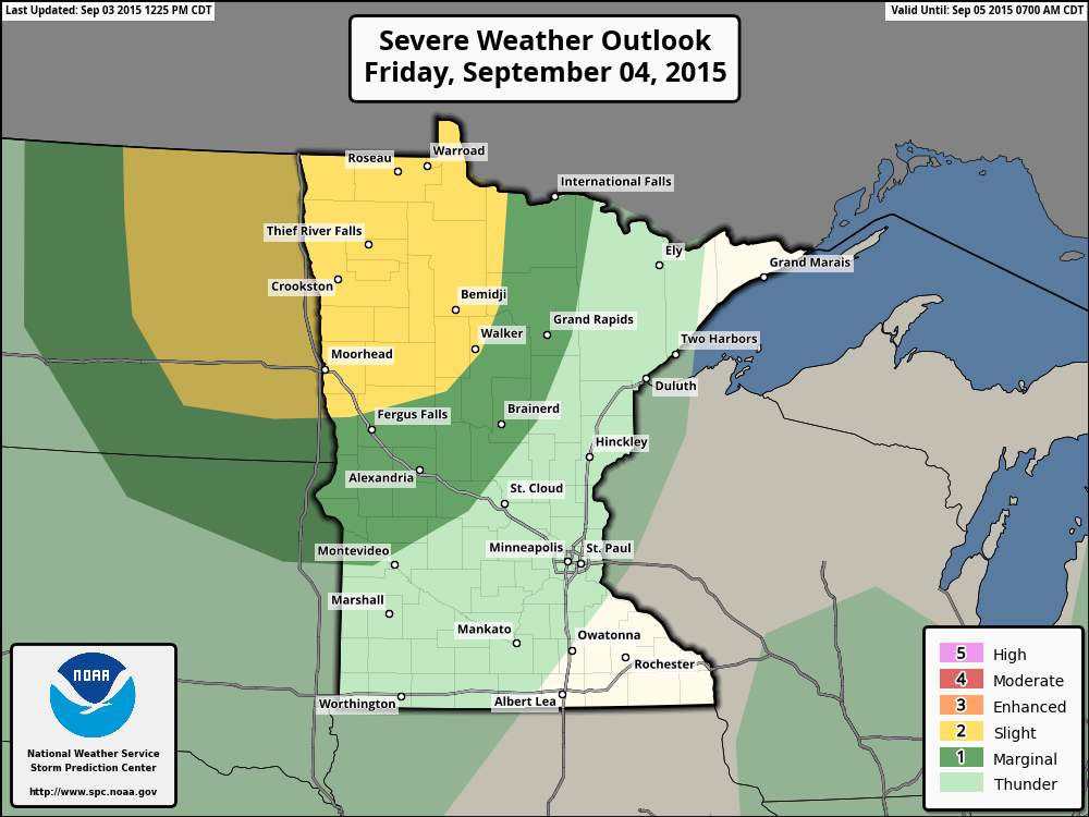
Severe Threat Friday
The approaching storm system will bring a round of strong to possibly severe storms to parts of the Red River Valley late Friday. This will likely be the first round of many to push through the region this weekend. For now, the Storm Prediction Center has far northwestern Minnesota under a SLIGHT Risk of severe weather...
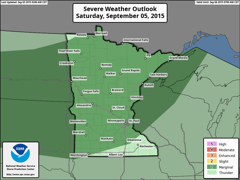
Saturday Severe Threat
The storm sytem will creep a little closer on Saturday with more widely scattered showers and storms late afternoon/overnight. Some of the storms shaded in dark green could be strong to possibly severe with some locally heavy rainfall... Stay tuned.
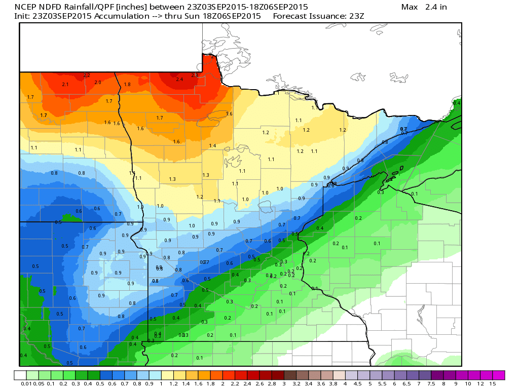
Rainfall Potential
The rainfall potential below (through midday Sunday) shows some of the heaviest across far northwestern Minnesota. However, rounds of strong thunderstorms and locally heavy rainfall will still be possible through the end of the weekend through much of the rest of the region.
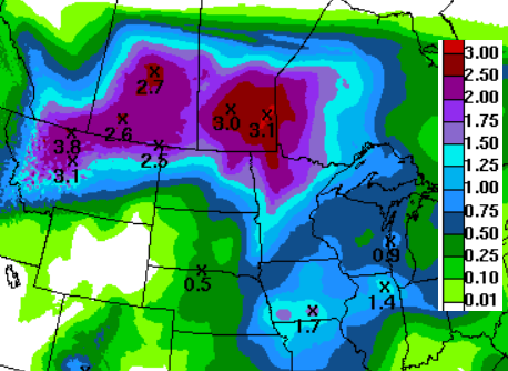
5 Day Rainfall Outlook
Here's the 5 day rainfall outlook, which suggests that some of the heaviest rainfall through the weekend/early next week will be found across central/northern Minnesota. Several rounds of strong thunderstorms could possibly pump out close to 1" to 3" of rain...
_________________________________
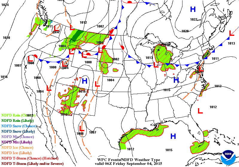
National Weather Outlook
Here's NOAA's weather outlook, which shows a blob of rain along the international border through early the early weekend. Rounds of heavy rain/thunder could make for some locally heavy rain amounts over the next 3 to 5 days.
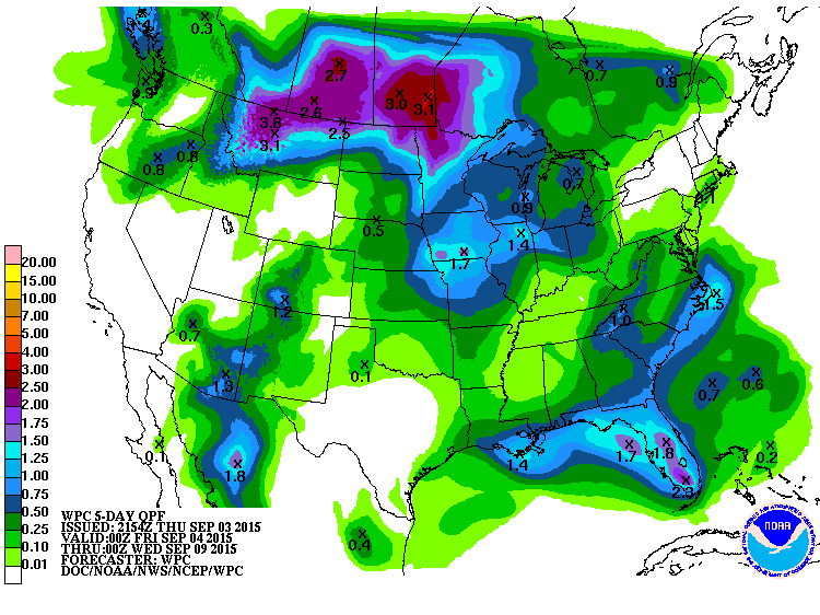
5 Day Precipitation Outlook
According to NOAA's WPC, the 5 day rainfall forecast suggests some of the heaviest rainfall potential from Montana to Minnesota into Canada with as much as 1" to 3"+ possible through early next week.
____________________________________________
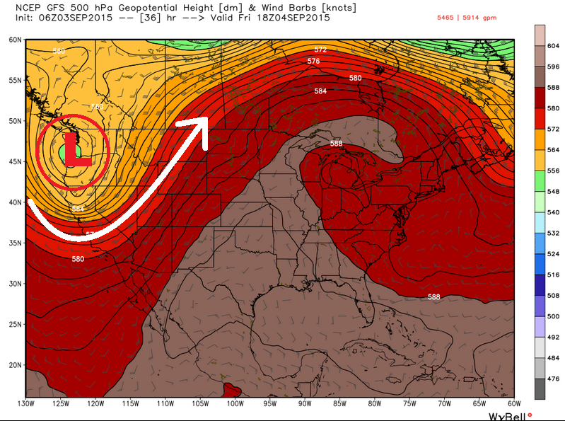
500mb Outlook
The image below shows an impressive ridge of high pressure over the eastern two-thirds of the country on Friday, which is responsible for our current hot, sticky weather. Note the area of low pressure in the Pacific Northwest. This will be responsible for more fall-like weather conditions as we head into the first FULL week of September next week.
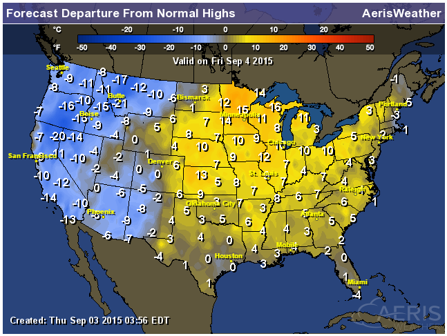
High Temperatures from Average on Friday
The map below corresponds to the 500mb map above. Note that the trough of low pressure and the ridge of high pressure (above) tend to mimic that of the cooler than average highs in the western U.S., while the ridge of high pressure tends to mimic that of the warmer than average highs in the eastern two-thirds of the country.
8 to 14 Day Temperature Outlook
Here's a wider view of the 8 to 14 day temperature outlook from NOAA's CPC. Note that by midmonth, much of the middle U.S. will likely see below average temperatures, while those along the coastal communities will have above average readings.
________________________________
Active Pacific Continues
The Pacific remains active with 4 ongoing storms! From left to right, Kilo, Ignacio, Jimena and Kevin. The good news is that none of these storms will pose any major threat to any major landmass.
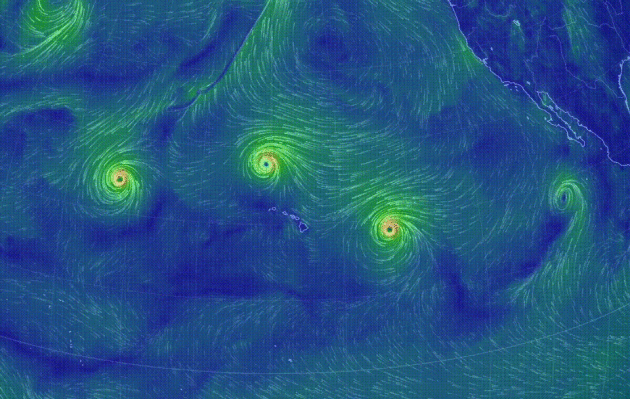
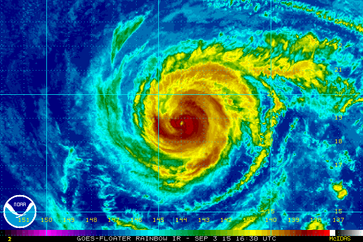
Hurricane Jimena
Hurricane Jimean continued in the Pacific Ocean late Thursday as a category 2 hurricane. The good news is that this storm will continue to drift northwest of the Hawaiian Islands.
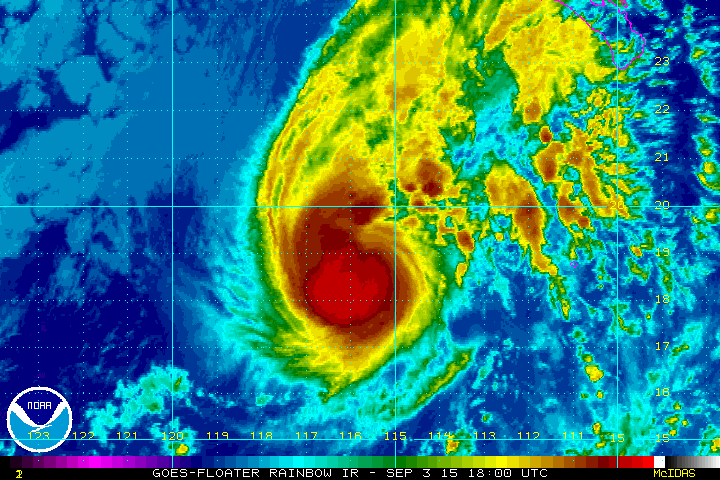
Tropical Storm Kevin
Here's newly formed Tropical Storm Kevin in the Pacific Ocean.
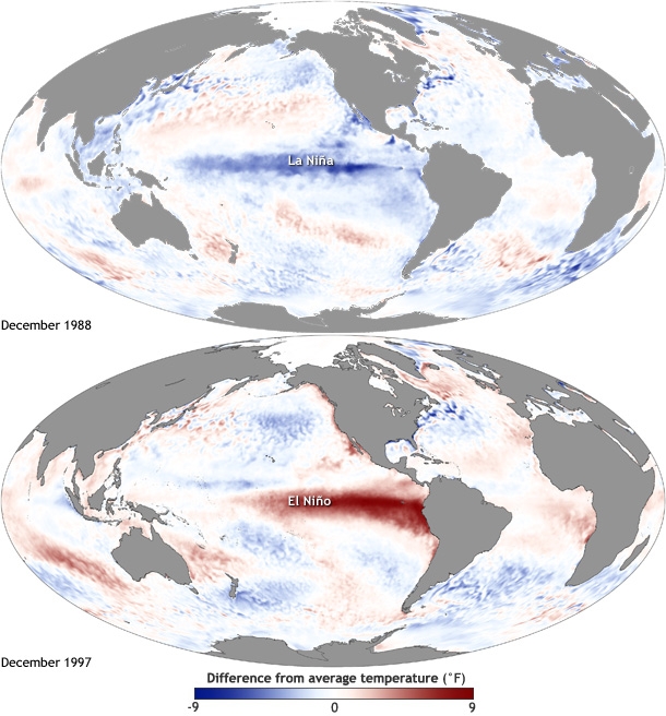
What is El Nino Anyway?
You may have heard a lot of talk about El Nino lately, but what exactly is El Nino? NOAA has a great article, which was posted earlier this Spring:
"1.) El Niño: A warming of the ocean surface, or above-average sea surface temperatures (SST), in the central and eastern tropical Pacific Ocean. Over Indonesia, rainfall tends to become reduced while rainfall increases over the tropical Pacific Ocean. The low-level surface winds, which normally blow from east to west along the equator (“easterly winds”), instead weaken or, in some cases, start blowing the other direction (from west to east or “westerly winds”).
2.) La Niña: A cooling of the ocean surface, or below-average sea surface temperatures (SST), in the central and eastern tropical Pacific Ocean. Over Indonesia, rainfall tends to increase while rainfall decreases over the central tropical Pacific Ocean. The normal easterly winds along the equator become even stronger.
3.) Neutral: Neither El Niño or La Niña. Often tropical Pacific SSTs are generally close to average. However, there are some instances when the ocean can look like it is in an El Niño or La Niña state, but the atmosphere is not playing along (or vice versa)."
Read more HERE:
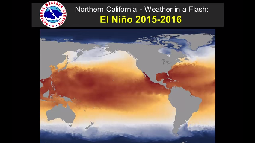
El Nino and it's Impacts on Northern California
Here's a video from the National Weather Service out of Sacremento, CA that explains how El Nino could impact nothern California:
See the video HERE:
_______________________________________-
Thanks for checking in and have a great rest of your week and weekend ahead! Don't forget to follow me on Twitter @TNelsonWX

No comments:
Post a Comment