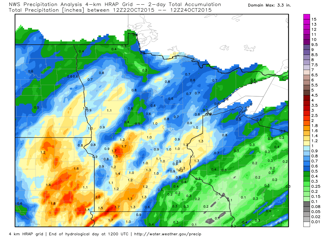
Prior to Friday, October had been a fairly dry month. Many locations were dealing with fairly decent precipitation deficits, but nearly an all day rain across parts of the state/region helped cut into some of those numbers. Take a look at the radar estimated rainfall from AM Thursday to AM Saturday below and not how widespread some of the 1"+ tallies were (including the Twin Cities). The official tally at Minneapolis was 1.18", this is the greatest 2 day tally we've seen since September 17th & 18th when 2.74" of rain fell.
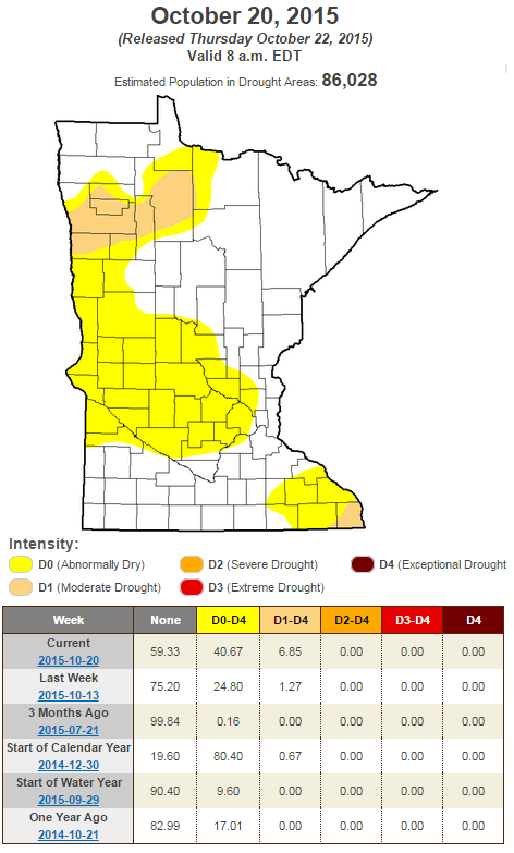
U.S. Drought Monitor
Prior to our rainfall on Friday, the U.S. Drought Monitor suggested that nearly 40% of the state was in abnormally dry conditions, including parts of the Twin Cities.
Halloween Climatology / Outlook
We're about a week away from fright night and it's kind of hard to believe that the end of October is almost here! While the average high in Minneapolis on October 31st is 51F and the average low is 34F, we can have a wide range of weather at this time of the year.
Take a look at some of the Halloween stats from the MN State Climatology Office below:
"Halloween is typically a time of crunchy leaves on the ground, and a bit of chill in the air. High temperatures in the Twin Cities are generally in the 40's and 50's. It is more common for the daily high on Halloween to be in the 60's than in the 30's. In spite of the 1991 Halloween Blizzard, measurable snow on Halloween is about as rare as getting a full sized candy bar in your trick or treat bag. Since 1872 there's been enough snow to measure only six times: .6 in 1884, .2 in 1885, 1.4 in 1932, .4 in 1954, .5 in 1995 and of course 8.2 inches with the Halloween Blizzard of 1991."

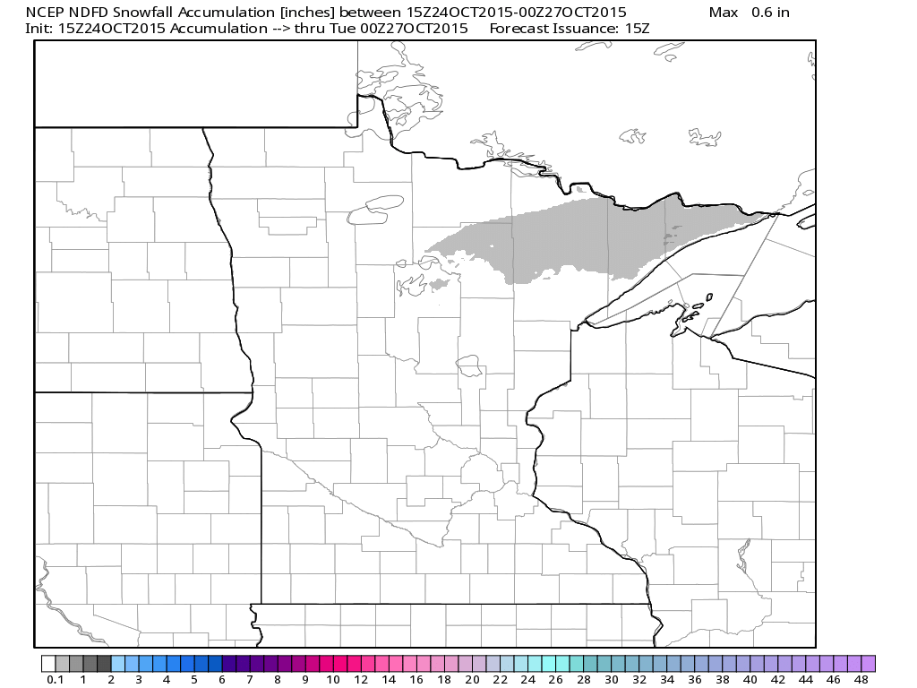
Northern MN Snowfall Potential This Week?
Although it doesn't look like much... a quick moving system will skirt across the international border PM Sunday through Monday and there could be enough cold air/moisture for a little light snow in the Arrowhead. Interestingly, the remnants of Patricia could meet up with another cold front from Canada near the Great Lakes could bring another chance of wet flakes across the northern half of the state by midweek... stay tuned!
_________________________
Quiet Sunday. Wet snowflake potential up north?
By Todd Nelson, filling in for Douglas
Sometimes I scratch my head at how amazing Mother Nature can be. Producing such spectacles, the most recent being Hurricane Patricia!
In 30 hours, Patricia went from tropical storm status to the strongest hurricane ever recorded in the Eastern Pacific! Sustained winds of 200mph became the strongest winds ever reliably recorded in any tropical cyclone in the world!
After landfall Friday evening with 165mph winds near Manzanillo, Mexico, it rapidly weakened. The remnants will be responsible for more flooding rain along the Gulf Coast through Monday. Interestingly, that moisture will continue lifting north toward the Great Lakes and get caught up with a cold front approaching from Canada. The result would be cold, wind-whipped rain for us and potentially some wet snowflakes near the international border by midweek!
With that said, enjoy today. The weather pattern looks a little more active over the next several days. Good news, no repeat 1991 Halloween Blizzards brewing. Next Saturday doesn't look too scary yet... BOO!
_________________________
SATURDAY NIGHT: Mostly clear, quiet and chilly! Winds: WNW 5. Low: 40
SUNDAY: Dry start, more PM clouds with an isolated shower risk up north. Winds: S 5. High: 59
SUNDAY NIGHT: More clouds, a few showers possible, mainly north. Winds: SSE 5. Low: 42
MONDAY: Stray AM shower, some PM sun. High: 57
TUESDAY: More PM clouds, rain develops late. Wake-up: 44. High: 59
WEDNESDAY: Windy with cold rain. Wake-up: 44. High: 52
THURSDAY: Chilly wind, spits of rain. Wake-up: 37. High: 48.
FRIDAY: Peeks of chilly sun. Wake-up: 35. High: 51.
SATURDAY: Bright sun. Not too scary. Wake-up: 38. High: 55.
_________________________
This Day in Weather History
October 25th
1887: Albert Lea set a record low of -6 degrees F.
1830: Heat wave at Ft. Snelling. Temperature reached 80.
_________________________
Average High/Low for Minneapolis
October 25th
Average High: 54F (Record: 82F set in 1989)
Average Low: 37F (Record: 12F set in 1887)
_________________________
Sunrise/Sunset Times for Minneapolis
October 25th
Sunrise: 7:41am
Sunset: 6:12pm
*Daylight lost since yesterday: ~2 minutes and 55 seconds
*Daylight lost since summer solstice (June 21st): ~5 hours and 6 minutes
_________________________
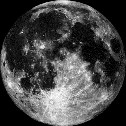
Moon Phase for October 25th at Midnight
1.2 Days Before Full Hunter's Moon
____________________________
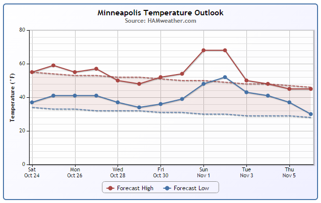
Minneapolis Temperature Trend
The temperature trend for Minneapolis through the end of October still looks to be close to average levels for this time of year. However, extended models suggests a bit of a warm up into early November!
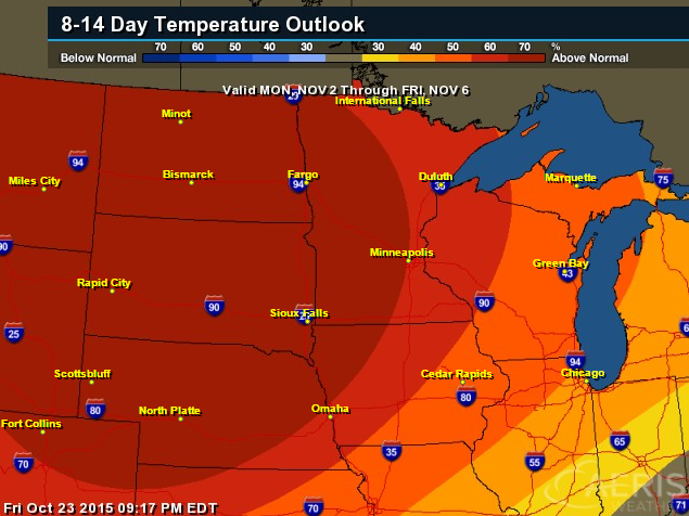
8 to 14 Day Temperature Outlook
According to NOAA Climate Prediction Center, The Midwest has a has a fairly decent chance at seeing above average temperatures heading into the early part of November. Keep in mind that the average high for Minneapolis falls from 50F on November 1st to 45F by November 9th, so even if we're above average, we still may need a few extra layers... stay tuned!
_________________________
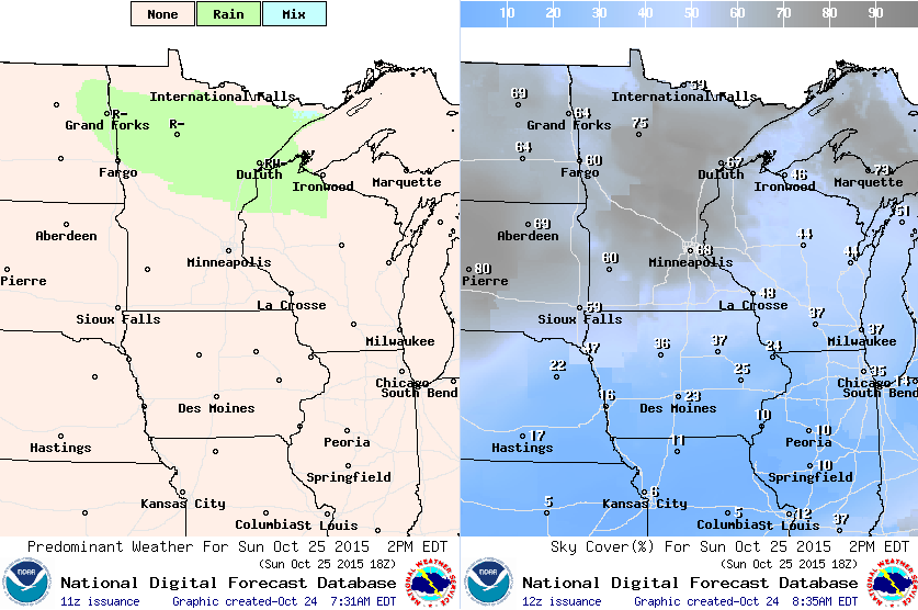
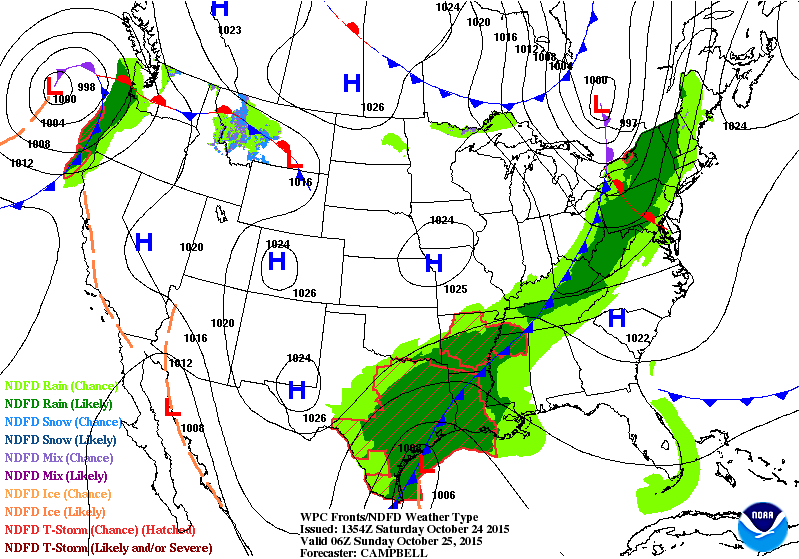
Sunday Weather Outlook
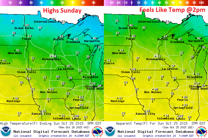
Sunday Weather Outlook
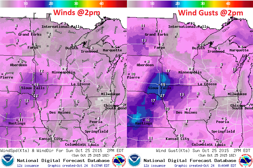
Sunday Weather Outlook
_________________________
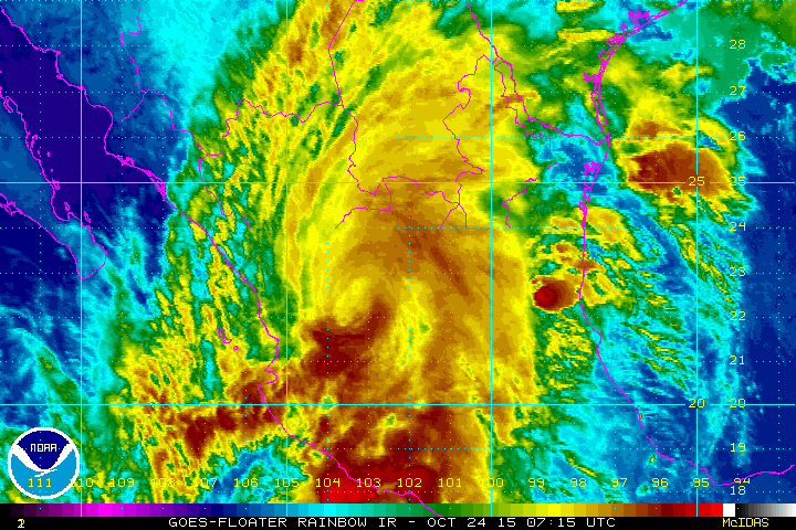
Hurricane Patricia
Hurricane Patricia become the strongest hurricane ever recorded in the Eastern Pacfic on Friday with top sustained wind speeds of 200mph and a central pressure of 879mb! Interestingly, the 200mph winds are the strongest winds ever reliably measured in any tropical cyclone in the world! At 6:15pm CDT, Hurricane Patricia made landfall as a category 5 storm with sustained winds of 165mph and a central pressure of 920mb near Manzanillo, Mexico
(Iimage courtesy: Astronaut Scott Kelly)

Video of Patricia Making Landfall Near Vallarta Jalisco
Take a look at this wild Youtube video of Hurricane Patricia making landfall near Vallarta Jalisco, Mexico:

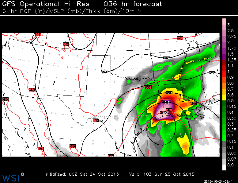
Patricia Fades; Brings Heavy Rain to U.S.
This was Tropical Storm Patricia from early Saturday. Interestingly, as quickly as Patricia strengthened into the strongest hurricane ever recorded in the Eastern Pacific, it weakened even faster over Mexico Friday night/Saturday. You can see the remnants of Patricia moving northeast toward Texas, which is expected to bring significant rain tallies to parts of the southern U.S..
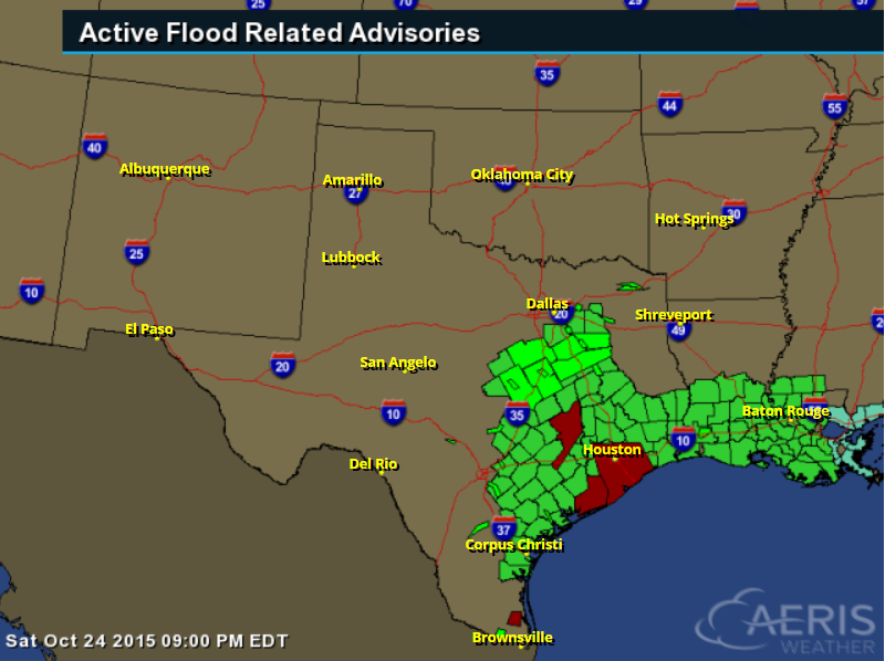
Remnants of Patricia to Bring More Heavy Rain to the Southern U.S.
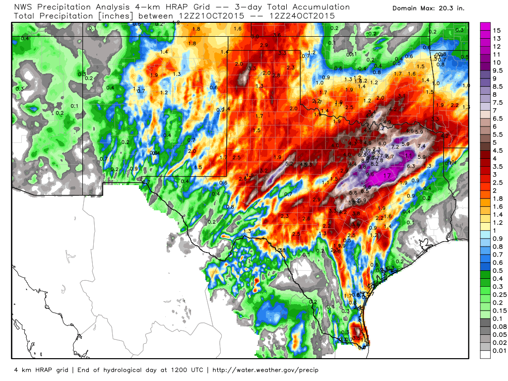
Radar Estimated Rainfall Past 3 Days
Prior
to any remnant Patricia moisture moving in, parts of the southern U.S.
saw significant quantities of rainfall last week. Take a look at the
radar estimated rainfall over a 3 day period from AM Wednesday to AM
Saturday and note that some areas have already seen nearly 6" to 10"+!
Flash Flood Concerns Continue Through Monday
The National Weather Service continues a number of flood concerns through early next week.
FLASH FLOOD WATCH THROUGH MONDAY MORNING
*
WIDESPREAD HEAVY RAINFALL IS EXPECTED TO DEVELOP AND SPREAD ACROSS THE
REGION ON SATURDAY. RAINFALL AMOUNTS OF 3 TO 6 INCHES ARE POSSIBLE NORTH
OF A COLUMBUS TO CLEVELAND LINE WITH RAINFALL AMOUNTS OF 6 TO 12 INCHES
POSSIBLE ACROSS THE REMAINDER OF SOUTHEAST TEXAS BY MONDAY MORNING.
ISOLATED AREAS COULD EXPERIENCE HIGHER AMOUNTS AREAWIDE. * THE RAINFALL
RATES TONIGHT AND INTO SUNDAY MAY EXCEED 3 INCHES PER HOUR WHICH WILL
EASILY LEAD TO STREET FLOODING. RIVER AND BAYOU FLOODING WILL BE
POSSIBLE WHERE THE HEAVIER AMOUNTS CONCENTRATE. BY SUNDAY NIGHT OR
MONDAY MORNING THE HEAVIER RAINS SHOULD DEPART THE AREA TO THE EAST BUT
THE THREAT OF RIVER AND BAYOU FLOODING COULD LINGER.
Additional Rainfall
As remnant moisture from Patricia moves northeast through the southern U.S. heavy rainfall will continue with more flood concerns. The image below suggests an additional 6" to 10"+ possible in spots across Texas and Louisiana through early this week.
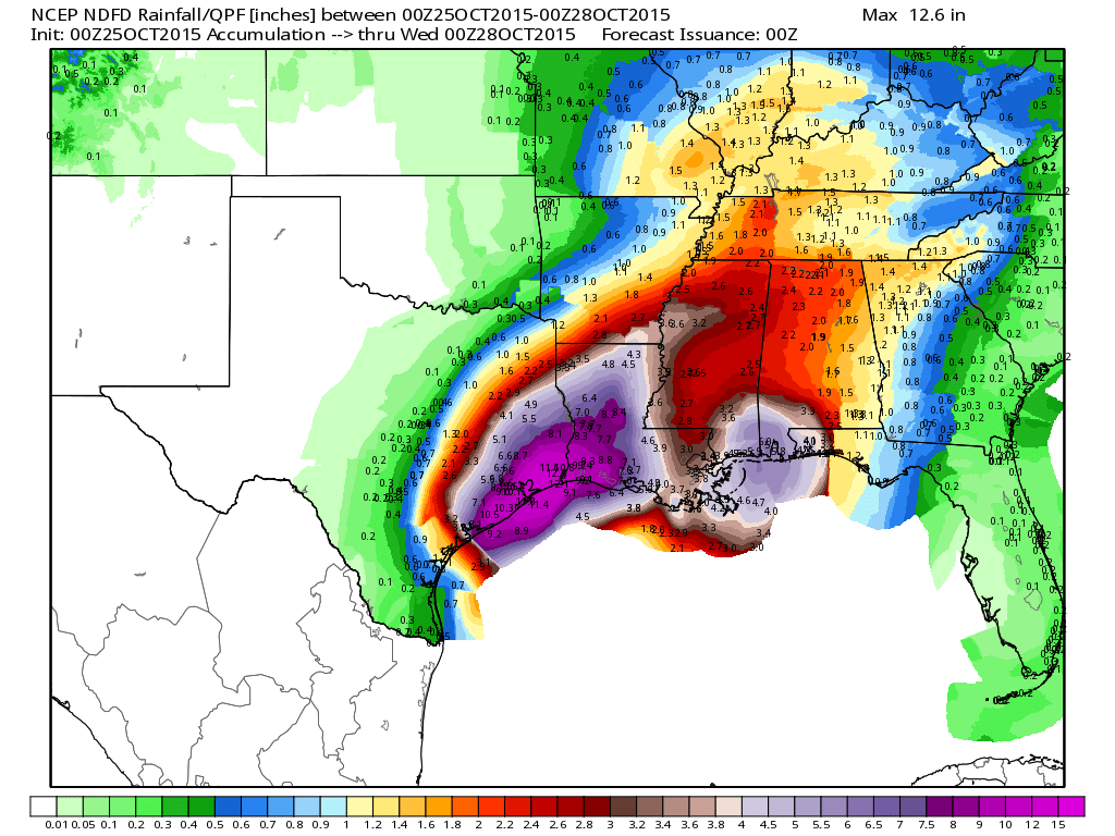
5 Day Precipitation Outlook
According to NOAA's WPC, the 5 day rainfall forecast suggests nearly 6" to 11"+ of rain possible near the Coastal Bend of Texas into southwestern Louisiana.
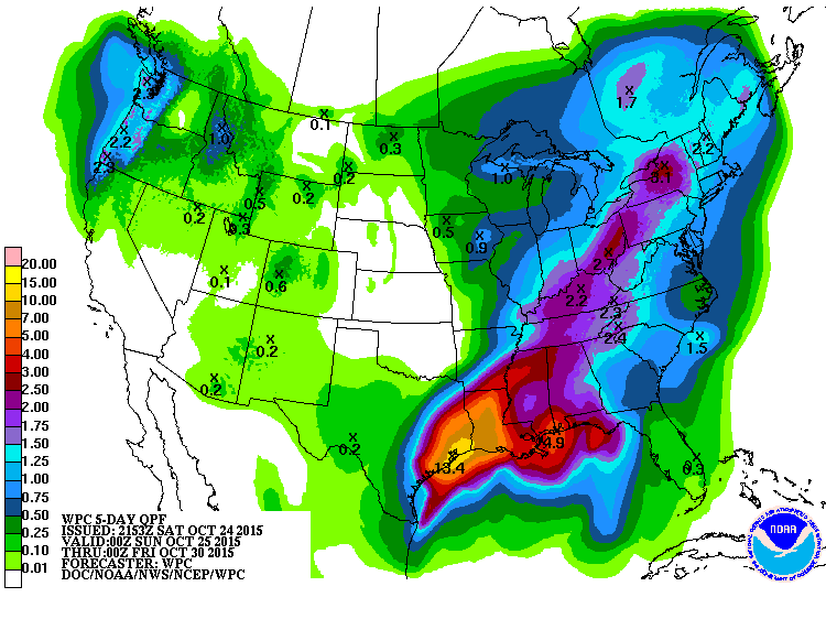
National Weather Outlook
The national weather outlook keeps heavy rain/flood concerns ongoing across the southern U.S. through early next week, while another storm system will begin to spread moisture into the northwestern part of the U.S.. Note that as moisture spreads through the Intermountain-West, some of it may turn to snow and mixed precipitation across the higher elevations.
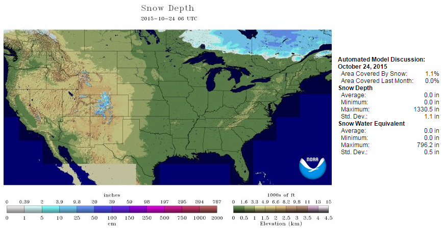
Snow Depth Increasing
It's not uncommon to see snow through the Intermountain-West at this time of year. In fact, as of October 24th, NOAA's NOHRSC suggested that nearly 1% of the nation was covered in snow. Note that there is a pretty decent swath of snow across eastern Canada!
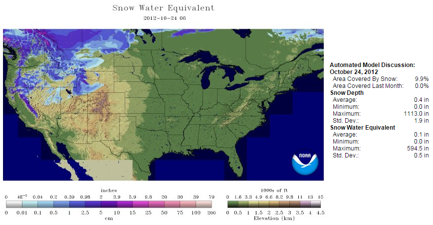
Snow Depth in 2012
I looked back and found that in 2012, nearly 10% of the nation was covered in snow on October 24th. Typically, the chances of snow coverage increase quite a bit as we head over the next several weeks.
_______________________________
Climate and Pumpkins
Here's an interesting story from NOAA regarding pumpkins and climate:
"A poor pumpkin harvest is spooking Halloween fans this year. Earlier this month, the internet was set afire with news of a pumpkin shortage after above-average rainfall in Morton, Illinois, the so-called “pumpkin capital of the world,” soaked soils during the crop’s critical growing period. Overall, precipitation has increased by about 2 inches in the early spring over the last century in central Illinois (Climate Division 4). This is consistent with an increasing trend in annual precipitation in the Midwest region during the past century (by up to 20 percent in some locations), with much of the increase driven by intensification of the heaviest rainfalls. According to the Third National Climate Assessment, this tendency towards more intense precipitation events is projected to continue in the future."
Read the full story from NOAA HERE:
(Pumpkins for sale. Creative Commons license by Sheila C.)

Thanks for checking in and have a great rest of your weekend! Don't forget to follow me on Twitter @TNelsonWX

No comments:
Post a Comment