On Friday, Hurricane Patricia become the strongest hurricane ever recorded in the Eastern Pacific with sustained winds of 200mph and a central pressure of 879mph! According to NOAA's NHC: At 6:15pm CDT, Hurricane Patricia made landfall near Cuixmala, Mexico, about 55 miles west of Manzanillo with estimated winds of 165 mph and a central pressure of 920mb. Making Patricia the strongest hurricane ever recorded to make landfall on Mexico's west coast! Interestingly, this was also the first category 5 hurricane to make landfall with North American since Dean in 2007!
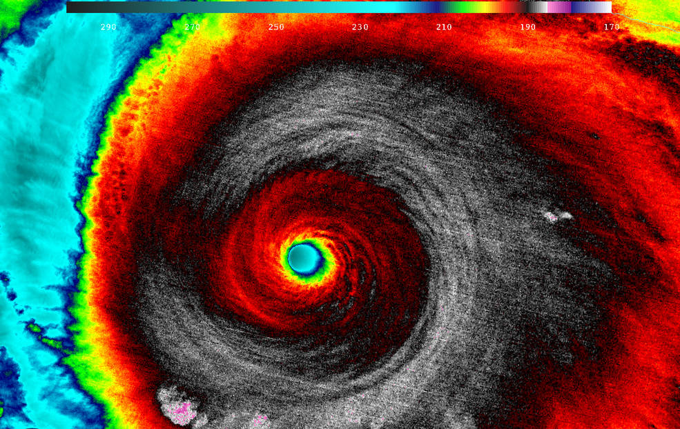
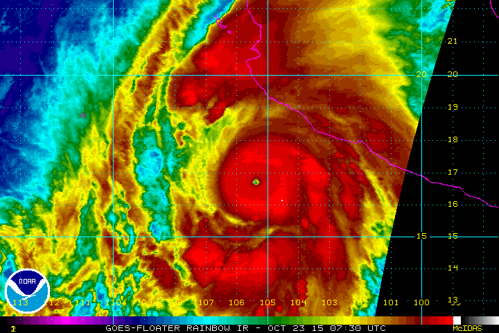
"When NASA-NOAA's Suomi NPP satellite
passed over Patricia on October 23 at 5:20 a.m. EDT the VIIRS instrument
that flies aboard Suomi NPP looked at the storm in infrared light.
Cloud top temperatures of thunderstorms around the eyewall were between
180K (-135.7F/ -93.1C) and 190 Kelvin (-117.7F/ -83.1C)."
Credits: UW/CIMSS/William Straka III
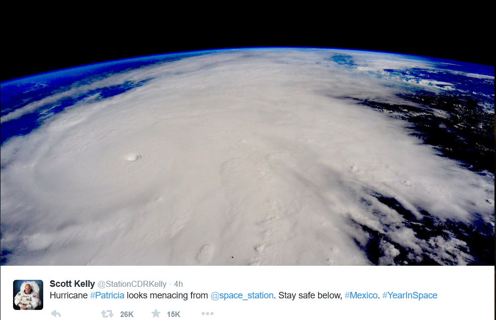
Patricia From Space
Thanks to @StationCDRKelly for the picture below. Scott Kelly is an astronaut aboard the ISS and this is the picture he tweeted on Friday.
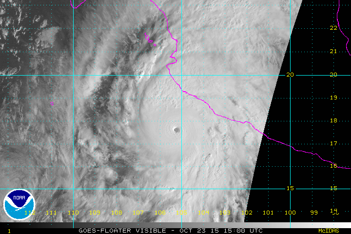
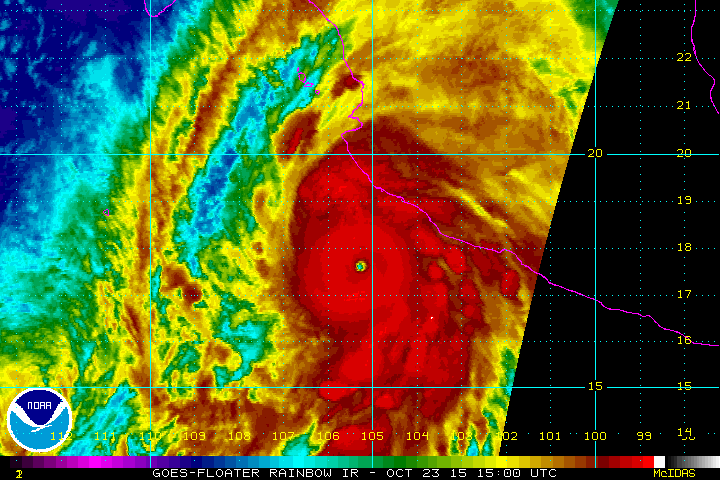
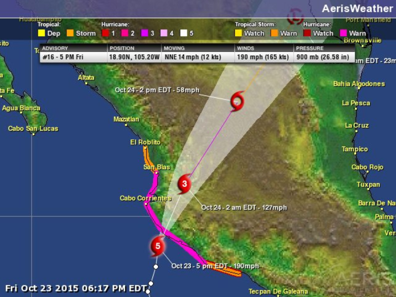
Category 5 Hurricane Patricia Just Before Landfall PM Friday
According to NOAA's National Hurricane Center, Hurricane Patricia was a category 5 storm with sustained winds of 190mph prior to landfall with the Mexican Coast Friday evening.
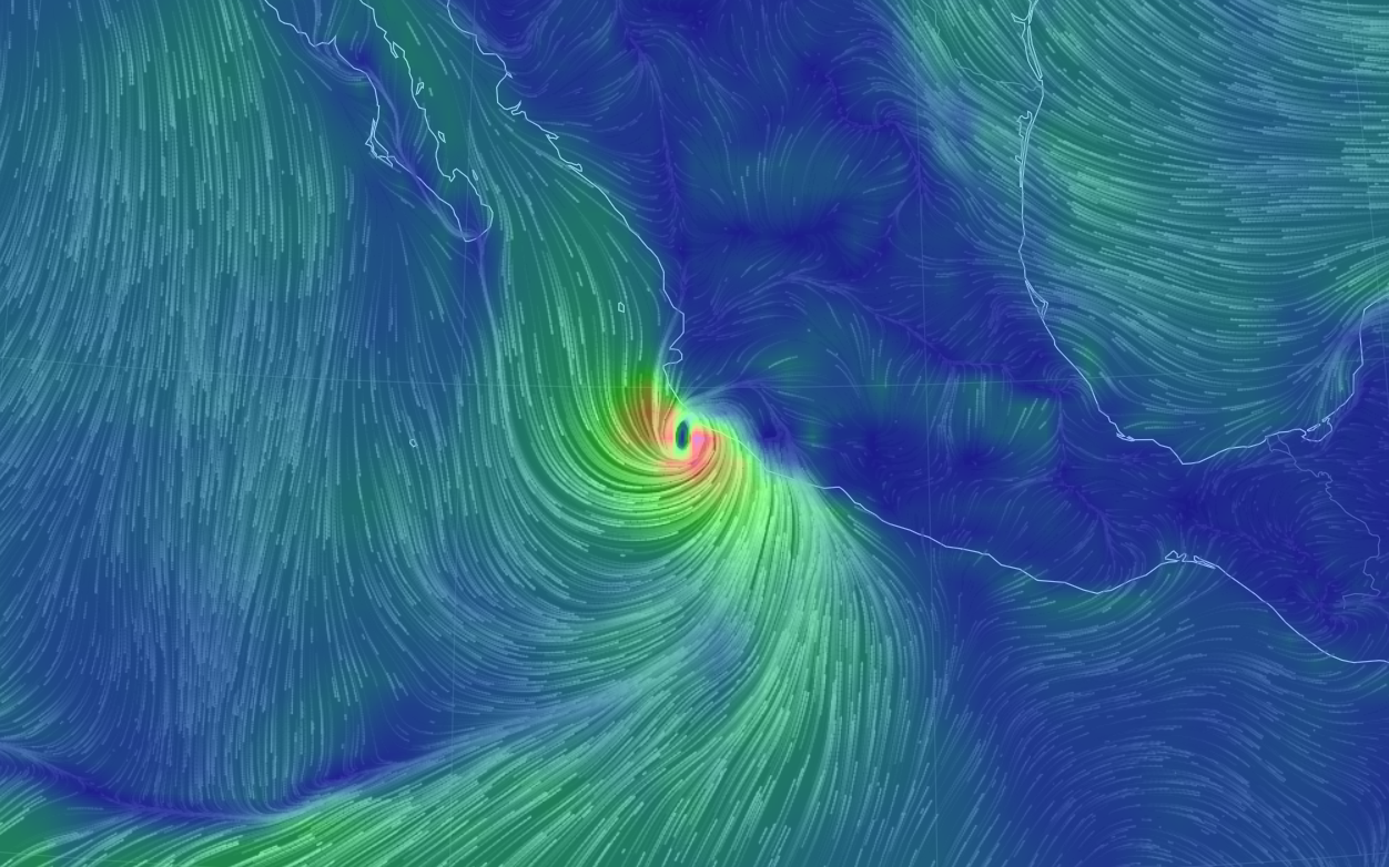
Winds Surrounding Patricia Prior to Landfall
Here's an interesting look at the wind field surrounding Patricia just prior to landfall. Interestingly, NOAA stated that category 5 winds were occurring over a very small area near the center - about 15 miles across. However, significant winds across a much wider area continued.
Last Update Prior to Landfall on Friday Evening
The last update from the National Hurricane Center at 5pm EST was category 5 storm with sustained winds around 190mph and a central pressure at 900mph. Patricia was estimated to have sustained winds of 165mph at landfall making it the strongest hurricane on record to ever hit the west coast!
More Stats on Patricia
As of early Friday, Hurricane Patricia was the strongest hurricane on record in the Eastern Pacific with sustained winds of 200mph and a central pressure of 879mb! Interestingly, Hurricane Patricia becomes the strongest tropical cyclone in the world (in terms of wind speeds officially recorded). "The previous record-holder for the strongest tropical cyclone ever recorded anywhere on Earth—by wind speed—was Super Typhoon Haiyan, which struck the Philippines with satellite-estimated, one-minute sustained winds of 195 MPH."
Other incredible stats:
- Patricia went from Tropical Storm status to becoming the strongest hurricane on record in the Eastern Pacific in 30 hours with a sustained winds of 200mph and a central pressure of 880mph
- The central pressure of Patricia dropped 100mb in 24 hours!
- The central pressure of Patricia dropped 73mb in 12 hours!
___________________________________
Historic Hurricane Patricia,
Fueled by El Nino?
By Paul Douglas
Tornadoes are terrifying, but come and go in the blink of an eye. Not to minimize the impact of floods, blizzards and a steady treadmill of natural disasters, there is nothing on Earth to compare to a Category 5 hurricane. "Patricia" was the strongest hurricane ever observed in the eastern Pacific, possibly the strongest hurricane ever tracked on the planet's surface, with sustained winds over 200 mph - roughly equivalent to a 40 mile wide EF-5 tornado, only one that lingered 3-6 hours. Incomprehensible.
A plume of tropical moisture from Patricia will fuel extreme flooding from Texas to Louisiana. There's a good chance additional warming of the Pacific from El Nino fueled this super-storm. I've never seen a storm strengthen so rapidly in such a short period of time.
Skies clear today; only a glancing blow of chilly air later this week. For the next 1-2 weeks prevailing winds aloft will blow from the Pacific, not the Yukon. The GFS hints at a day or 2 above 60F the first week of November.
Minnesota's weather is an afterthought - as Mexico grapples with a true catastrophe.
__________________________
FRIDAY NIGHT: Mostly cloudy. A few lingering showers possible. Winds: SSE 5-10. Low: 48.
SATURDAY: Damp start, then clearing. Winds: NW 10-15. High: 58
SATURDAY NIGHT: Mostly clear, quiet and chilly! Winds: WNW 5. Low: 40
SUNDAY: Dry start, isolated PM shower risk. Winds: SSW 5-10. High: 57
MONDAY: Cool, bright sun. Wake-up: 38. High: 55
TUESDAY: Partly sunny, milder. Wake-up: 43. High: 61
WEDNESDAY: Chance of showery rains. Wake-up: 45. High: 53
THURSDAY: Slow clearing and cool. Wake-up: 46. High: 52.
FRIDAY: Increasing clouds, showers late?. Wake-up: 32 High: 48
_____________________________
This Day in Weather History
October 24th
1922: Storm over Minnesota brings 55 mph winds at Collegeville.
_____________________________
Average High/Low for Minneapolis
October 24th
Average High: 54F (Record: 80F set in 1989)
Average Low: 37F (Record: 15F set in 1887)
_____________________________
Sunrise/Sunset Times for Minneapolis
October 24th
Sunrise: 7:40am
Sunset: 6:14pm
*Daylight lost since yesterday: ~2 minutes and 56 seconds
*Daylight lost since summer solstice (June 21st): ~5 hours and 3 minutes
______________________________
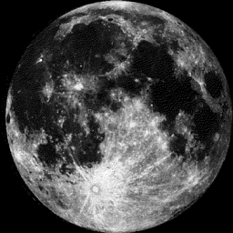
Moon Phase for October 24th at Midnight
2.2 Days until Full Hunter's Moon
__________________________________
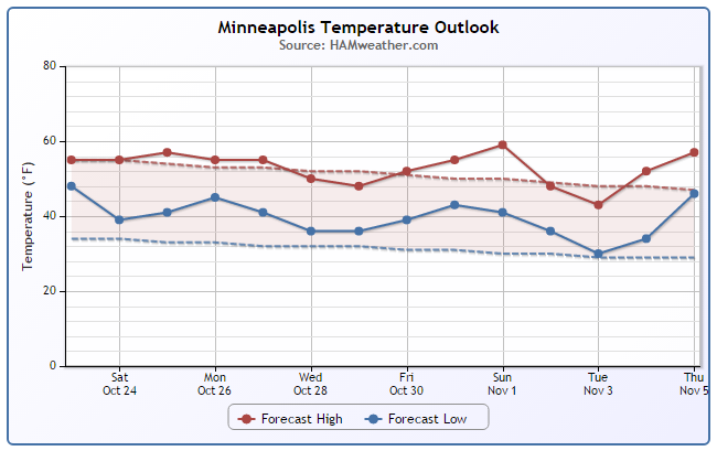
Minneapolis Temperature Trend
Through the first 22 days of October, temperatures are running nearly 3F degrees above average. Looking at the extended forecast, reading should be a little closer to average through much of the rest of the month.
_________________________________
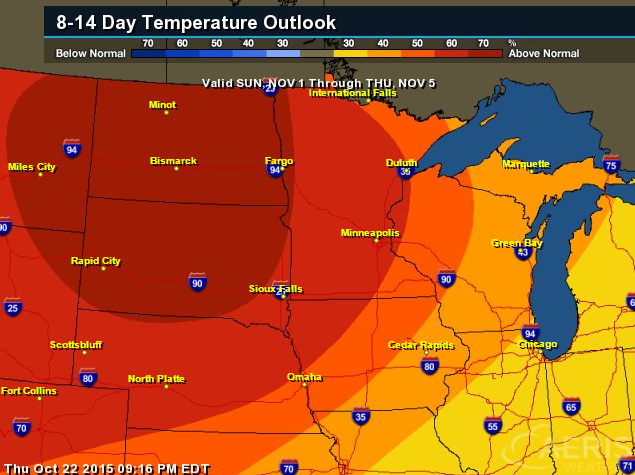
8 to 14 Day Temperature Outlook
According to NOAA's Climate Prediction Center, the 8 to 14 day temperature outlook suggests warmer than average into early November.
________________________________
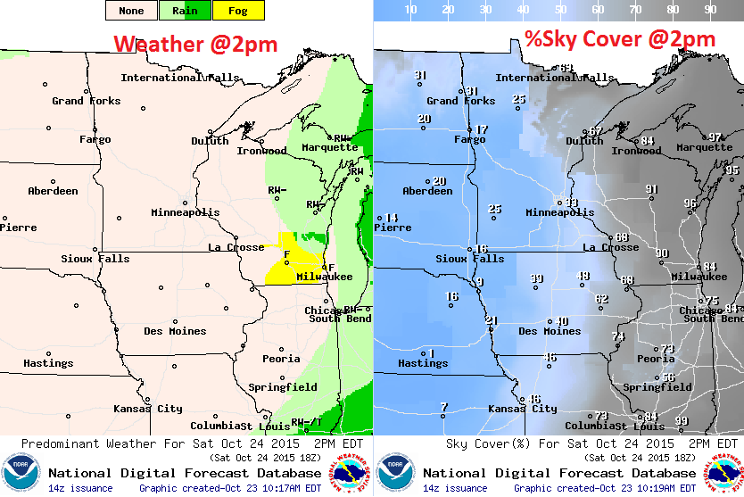
Saturday Weather Outlook
Cooler temps continue on Saturday with highs in the 50s across much of the state. It'll be damp to start, but drier weather and sunshine will move in later in the day.
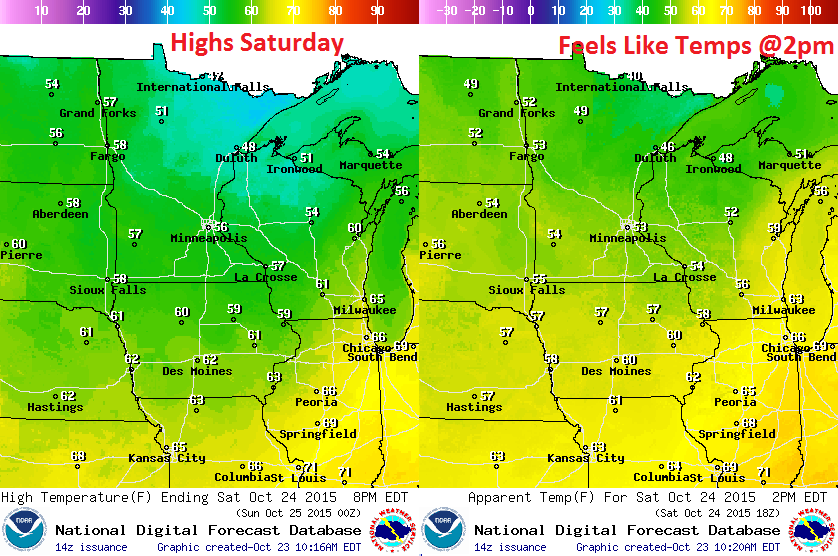
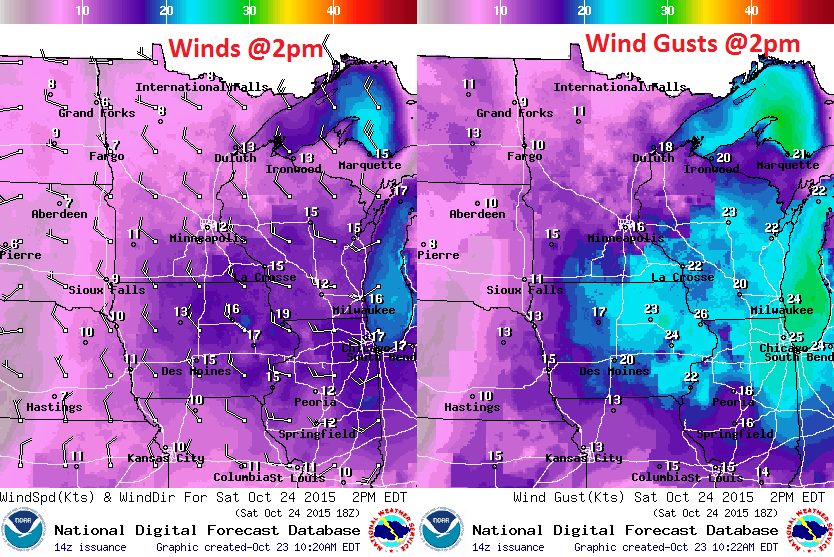
Saturday Weather Outlook
Winds will pick up a bit out of the WNW post storm system Saturday, making it feel a little cooler than the actual air temperature would suggest. Keep in mind the strongest winds will begin shifting east as the storm system moves east through the day.
Saturday Weather Outlook
Soggy weather conditions will be in place early Saturday, but a slow clearing trend will take us into the afternoon/evening hours with some sun and clear skies.
________________________________
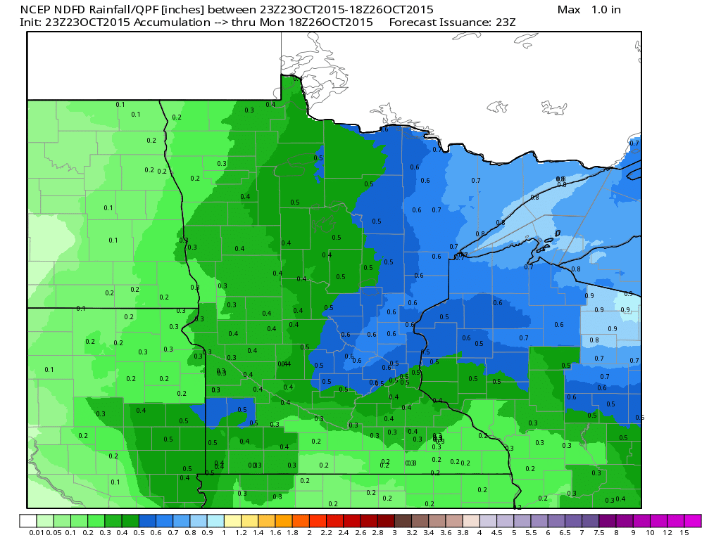
Minnesota Rainfall Potential
Rainfall will begin to taper late Friday/AM Saturday. Prior to that, any additional heavy rainfall will be confined to parts of NE Minnesota and northern Wisconsin.
____________________________________
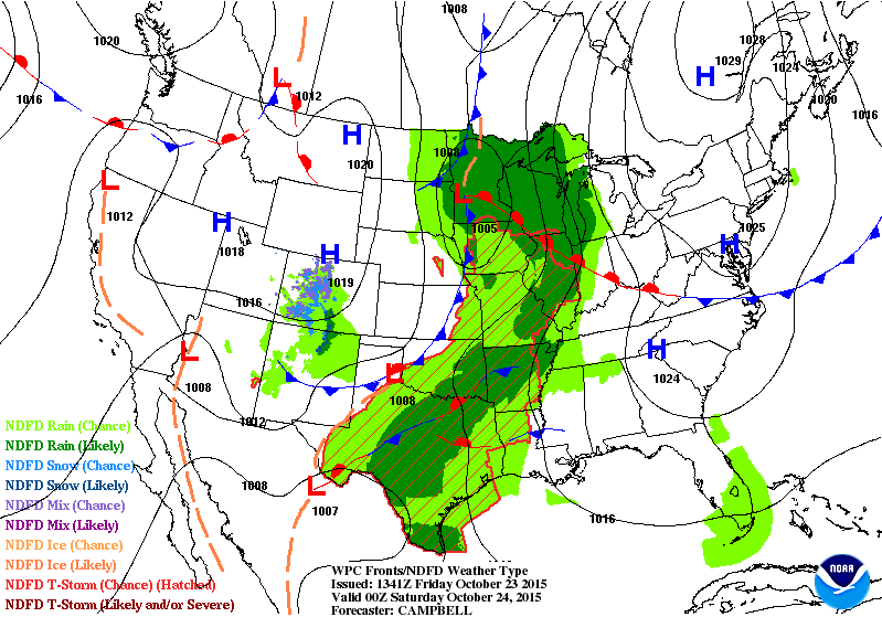
National Weather Outlook
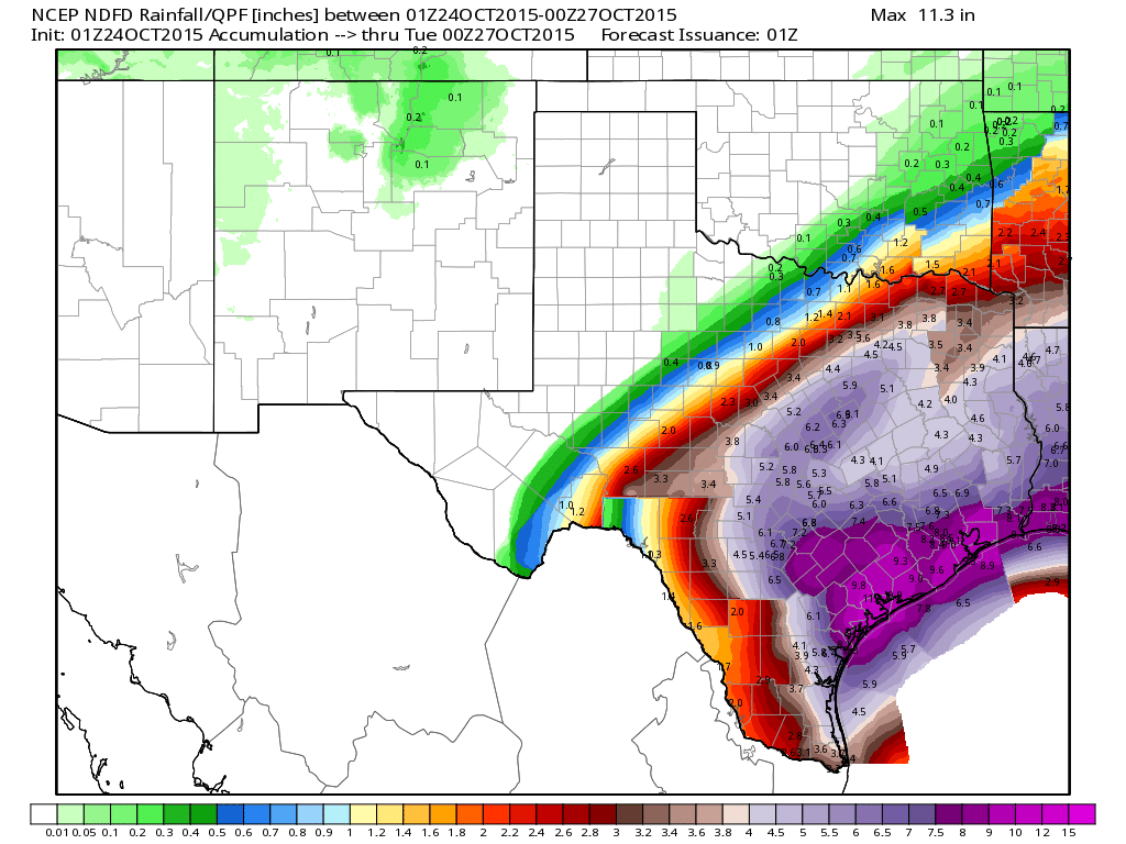
The middle part of the country will be pretty active over the next few days, especially in the Deep South, where remnants of Hurricane Patricia will begin to move in. The remnants of Patricia will be responsible for additional heavy rain this weekend across the Southern Plains and Lower Mississippi Valley!
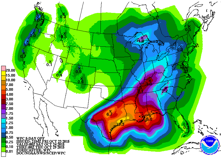
5 Day Precipitation Outlook
According to NOAA's WPC, the 5 day rainfall forecast suggests additional heavy rain across the Gulf Coast States with as much as 6" to 10"+ possible through the middle part of next week. Some of this remnant moisture from Patricia could even make it up into parts of the Ohio Valley with some fairly decent rainfall tallies across parts of Kentucky by the middle part of the week.
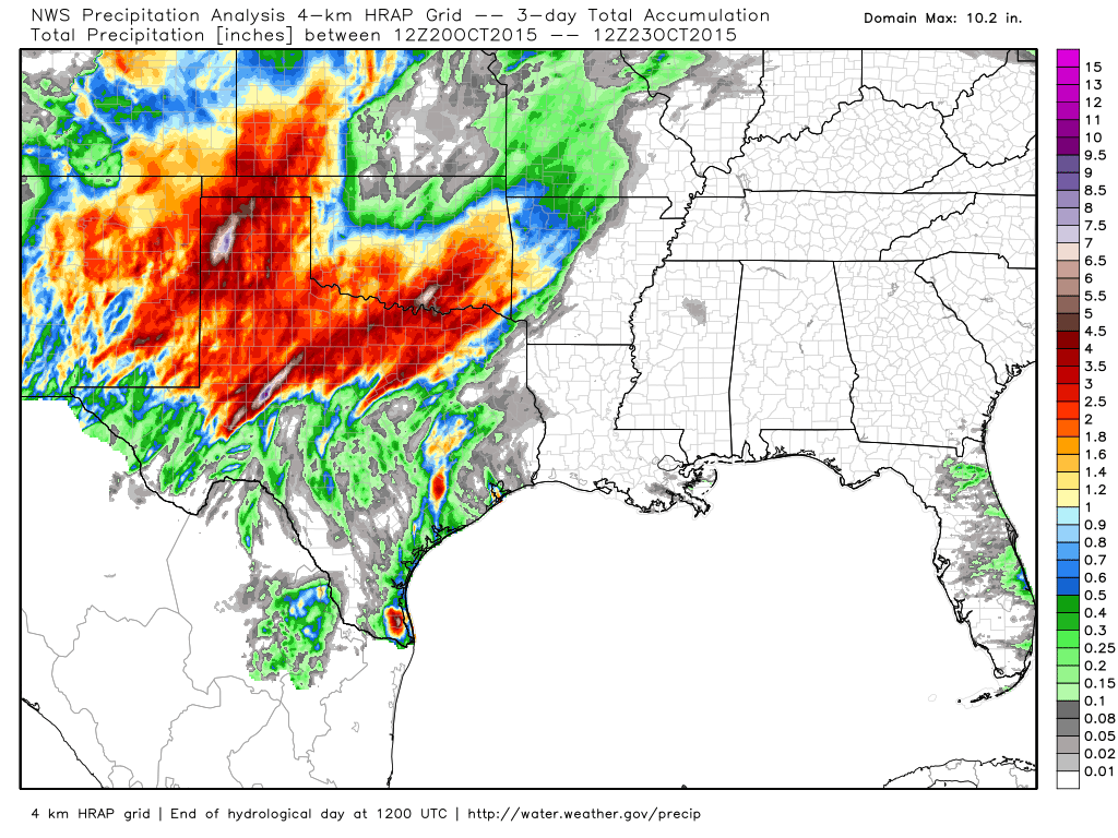
Heavy Texas Rain
Here's the radar estimated rainfall over a 3 day period from AM Tuesday to AM Friday. Note how widespread the 2"+ rainfall amounts have been with a few spots seeing nearly 5" to 6" or more!
Additional Rainfall in Texas
According to NOAA's WPC, the rainfall potential across parts of Texas and Louisiana suggests nearly 6" to 10"+ as the remnants of Hurricane Patricia move in over the weekend/early next week.
________________________________
Thanks for checking in and have a great weekend ahead! Don't forget to follow me on Twitter @TNelsonWX

No comments:
Post a Comment