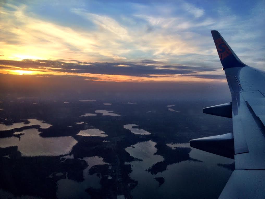
This was my view on my way back from Arizona with family on Tuesday evening. Minnesota sure is a pretty state! While you can pick out some of the lakes
______________________________
Colorado Snow
An area of low pressure located over the Central Rockies earlier this week is responsible for some fairly decent snowfall tallies in the higher elevations. This was the scene from Berthoud Pass in Clear Creek county, Colorado early Thursday.

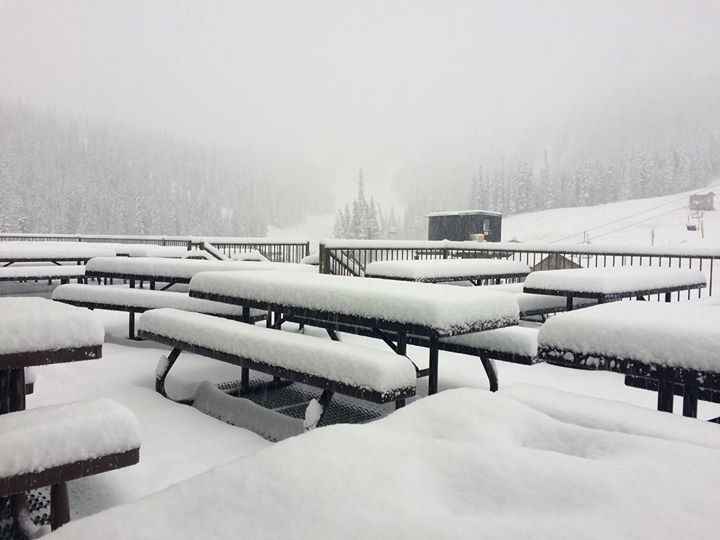
Monarch Mountain
Here's another shot from Monarch Mountain in Colorado! Their report from early Thursday was 4" of snow in the last 24 hours! I'm sure skiers and snowboarders are getting quiet excited for the upcoming season!
See more from Monarch Mountain
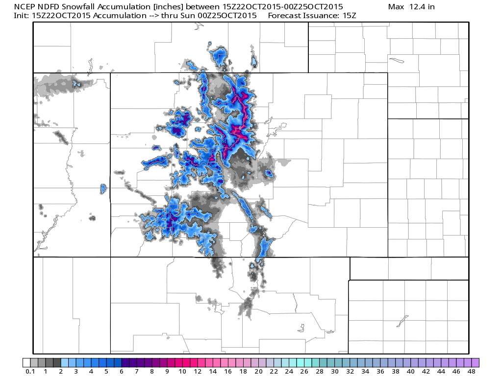
Colorado Snowfall Potential
Here's the snowfall potential through PM Saturday, which shows some locations in the higher elevations getting close to 6" to 10",
______________________________
Friday Puddles
Pondering Implications of El Nino
By Paul Douglas
When in doubt look out the window. The best first guess is a continuation of the current pattern; milder and drier than normal. Thank El Nino for the lukewarm nudge in steering winds. With any luck jet stream winds may be blowing from Vancouver and Portland much of the winter, instead of The Yukon. That's not to say we won't have cold invasions and snowy commutes, but the volume of bitter air may be less this winter, at least for the Upper Midwest.
El Nino winters tend to be stormier for the southern and eastern USA, but a Pacific flow tends to keep Minnesota drier, and more tolerable in the temperature department.
Today may be the wettest day since September 17, when 2.37 inches fell at MSP. Considering October rainfall is a third of an inch, almost 2 inches drier than average, we need moisture. Half an inch or more of rain may fall today and tonight but skies clear Saturday. A chilly slap arrives the middle of next week; 1-2 days in the 40s, but models hint at 60F again next weekend. Amazing.
Meanwhile a tropical system may drop historic rainfall on Texas early next week.
_______________________
THURSDAY NIGHT: Partly cloudy, showers develop late. Low: 47
FRIDAY: Periods of rain. Winds: SE 10-20. High: 58
FRIDAY NIGHT: Mostly cloudy. A few lingering showers possible. Winds: SSE 10-15. Low: 48.
SATURDAY: A few showers early. Then clearing and cooler. Winds: WNW 10-15. High: 59
SUNDAY: Mix of clouds and sun. Winds: S 5-10. Wake-up: 44. High: 58
MONDAY: Intervals of cool sunshine. Wake-up: 45. High: 57
TUESDAY: Few showers up north. Wake-up: 46. High: 60
WEDNESDAY: Cold rain possible, raw. Wake-up: 42. High: 46
THURSDAY: Sun returns, winds east. Wake-up: 36. High: 53.
__________________________
This Day in Weather History
October 23rd
1899: Warm day in the Twin Cities with a high of 82
__________________________
Average High/Low for Minneapolis
October 23rd
Average High: 55° (Record: 82° set in 1899)
Average Low: 37° (Record: 17° set in 1936)
__________________________
Sunrise/Sunset Times for Minneapolis
October 23rd
Sunrise: 7:39am
Sunset: 6:15pm
*Daylight lost since yesterday: ~2minutes and 57seconds
*Daylight lost since summer solstice (June 21st): ~5hours
_____________________________
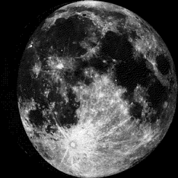
Moon Phase for October 23rd at Midnight
3.2 Day Before Full (Hunter's) Moon
________________________________
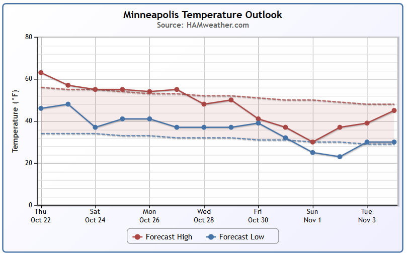
Minneapolis Temperature Trend
Even though temperatures are running nearly 3F above average so far this month, It, no doubt, feels like fall, doesn't it? Looking at the temperatures over the next few days, we should be a little closer to average through the middle part of next week. It appears that we may be in for a bigger temperature drop by the end of the month/early November... stay tuned!
___________________________________
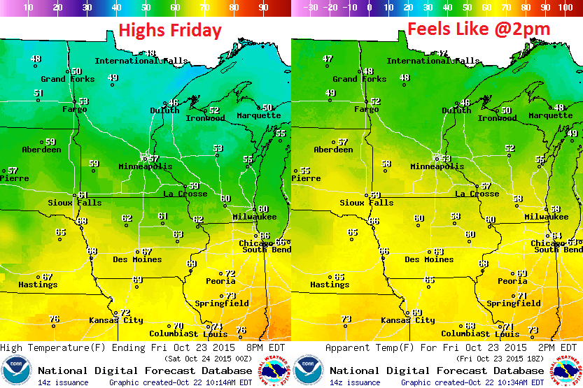
Friday Weather Outlook
Temperatures on Friday will be a little cooler than they were on Thursday. Mostly cloudy skies, breezy winds and scattered rain showers will make it feel even cooler. Hello Fall!
Friday Weather Outlook
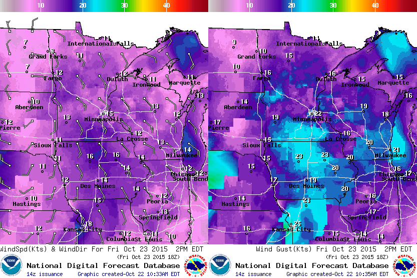
An approaching storm system will be responsible for stronger winds on Friday. Wind could gust to near 20mph across parts of southern Minnesota by the afternoon.
Friday Weather Outlook
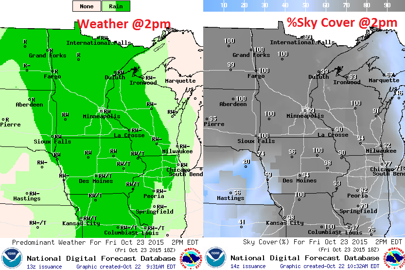
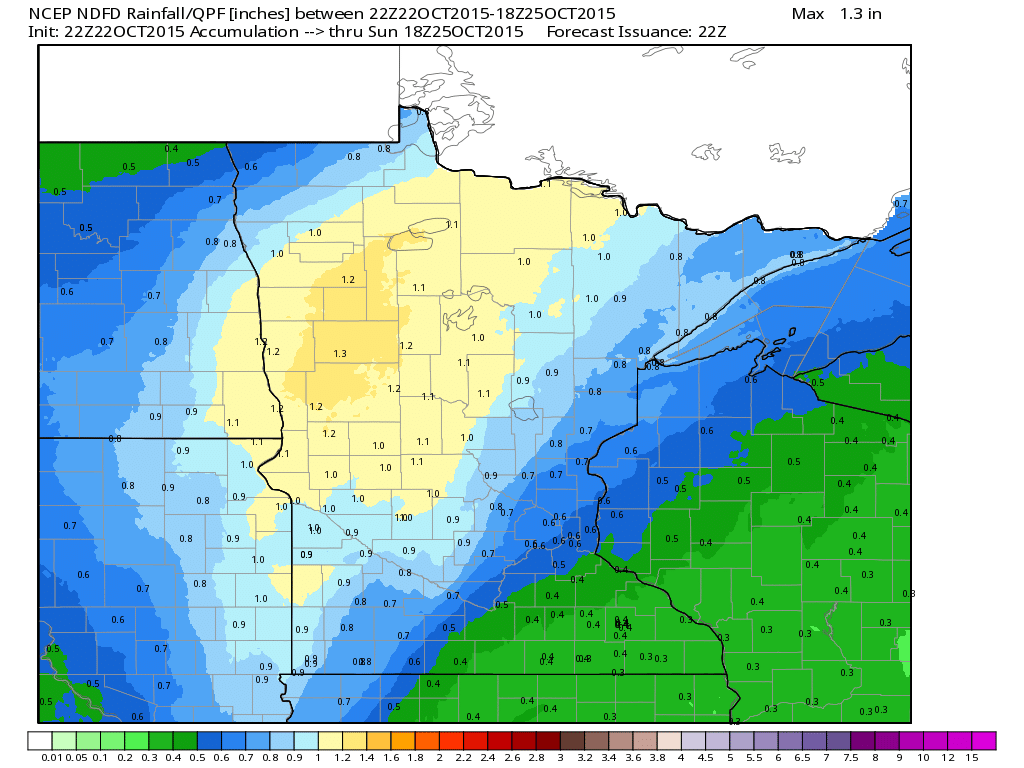
An area of low pressure lifting through the High Plains will be host to steady light to moderate rain across much of the on Friday. Some of the heaviest/steadiest rain will be found across the Dakotas and northern Minnesota. The images below depict potential weather conditions at 2pm Friday.
Rainfall Potential
Note the best chance for heavy rainfall through Saturday looks to be across parts of North Dakota and Northern MN. Some spots could see up to 1" or more, while areas in far southeastern Minnesota may only get a couple of tenths of an inch of rain. The Twin Cities looks to be right on the edge of some of the heavier stuff.
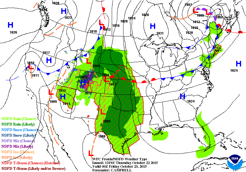
National Weather Outlook
The rain spreading through the the Upper Midwest on Friday is part of a much larger storm system that brought snow to parts of Colorado and flooding rain to Texas earlier this week. Unfortunately, the heavy rain in the Southern Plains isn't quite over yet. Remnants from Hurricane Patricia in the Eastern Pacific could help to bring even heavier rainfall to some of the same areas this weekend.
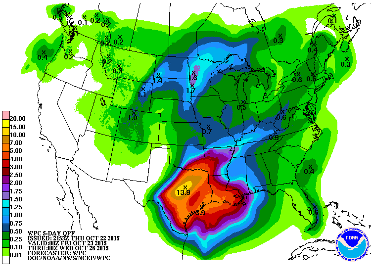
5 Day Precipitation Outlook
According to NOAA's WPC, the 5 day precipitation forecast suggests nearly 6" to 12"+ rain possible across parts of the Southern Plains/Texas through early next week.
____________________________________________
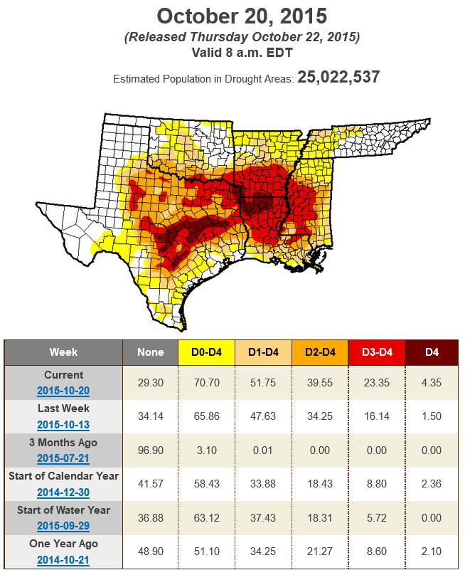
Texas Drought
According to the U.S. Drought Monitor, more than 50% of the South is considered to be in a moderate drought or worse. While flooding is expected, this heavy rainfall will help with drought conditions
_______________________________________
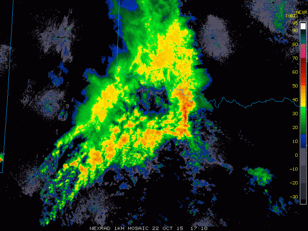
Heavy Southern Rain
The southern flank of this particular storm is helping to dump copious amounts of rain across the Southern Plains. This was the radar from earlier Thursday across parts of Texas and Oklahoma.
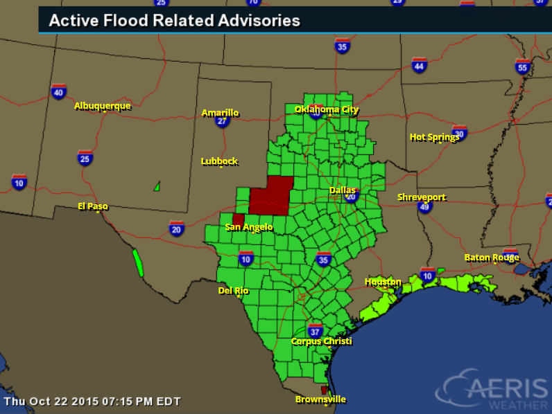
Flash Flood Concerns
The National Weather Service has a number of flood concerns posted from Texas to Oklahoma as heavy rains are expected to continue through the early weekend.
...FLOOD WATCH REMAINS IN EFFECT THROUGH FRIDAY MORNING...
THE FLOOD WATCH CONTINUES FOR * PORTIONS OF NORTHWEST TEXAS AND THE PANHANDLE OF TEXAS...
* STORM TOTAL RAINFALL AMOUNTS OF 2 TO 4 INCHES WILL BE COMMON WITH LOCALLY HIGHER AMOUNTS LIKELY. SOME AREAS COULD SEE STORM TOTAL RAINFALL AMOUNTS OF 3 TO 6 INCHES.
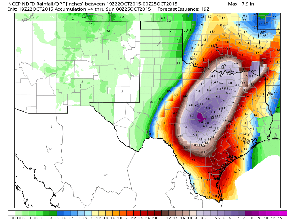
Heavy Texas Rains
Here's a look at the potential rainfall across parts of Texas and Oklahoma through PM Saturday. Note the maximum over the central part of the state near 6" to 7"+. However, note how widespread other heavy tallies will be even into parts of Oklahoma.
____________________________________________
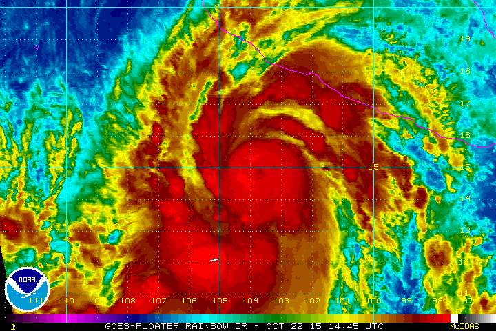
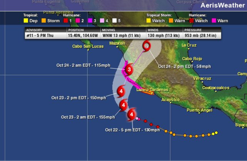
Hurricane Patricia Threatens Mexico: Puerto Vallarta and Manzanillo
As of 5pm EDT Thursday, Category 4 Hurricane Patricia had sustained winds of 130mph in the Eastern Pacific and was located south of two major resort cities of Puerto Vallarta and Manzanillo. Note the small eye that developed just south of Mexico! Interestingly, this particular storm will help to bring parts of the Southern Plains more heavy rainfall as we head through the weekend!
Tracking Patricia
Patricia rapidly developed into a category 4 storm on Thursday. Unfortunately, this storm is expected to make landfall with Mexico as a major hurricane with significant winds and significant rainfall.
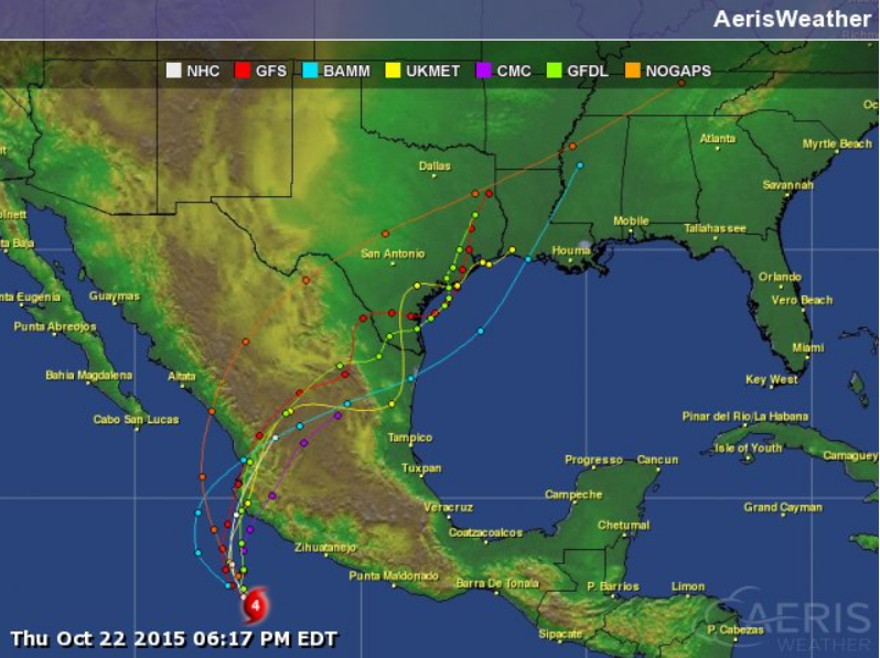
Spaghetti Plots
The image below shows different model solutions for Hurricane Patricia as it moves closer to and over Mexico. Interestingly the models seem pretty consistent with the track through central Mexico. Keep in mind that this track would likely bring significant potentially life-threatening flooding to some of these areas.
___________________________________
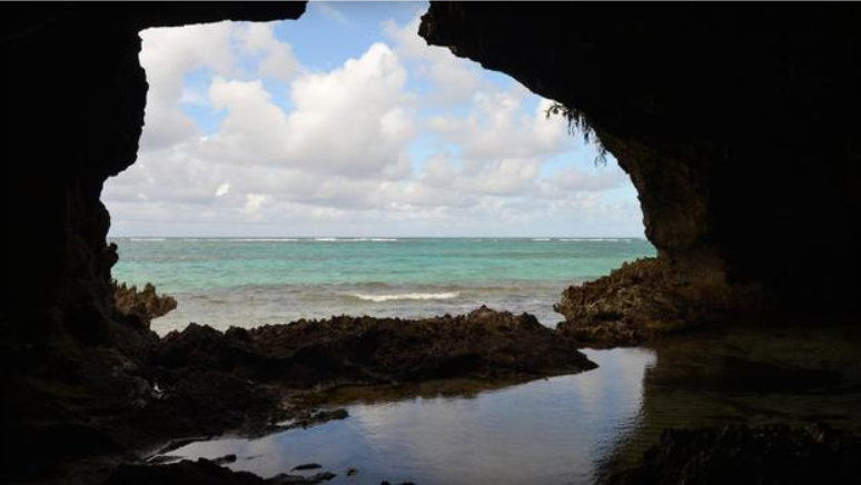
Which is Worse for Wildlife - Climate Change or Humans?
"A new study published in the Proceedings of the National Academy of Sciences journal poses the provocative argument that mankind did more damage to wildlife in the Caribbean than radical shifts in the area's climate thousands of years ago. The research team, lead by the University of Florida, examined 95 fossil species from a flooded cave on the Great Abaco Island, the third largest in the Bahamian Archipelago. They identified 17 species of birds that were casualties of the dynamic climate changes of the Ice Age 10,000 years ago and 22 other species of mammals, reptiles, and birds that survived. These animals adapted to their changing environment, thriving for another 9,000 years. But they disappeared once humans came to the island about 1,000 years ago."
Read more from CBSNews.com HERE:
(Image courtesy: University of Florida)
Thanks for checking in and have a great rest of your week/weekend ahead.

No comments:
Post a Comment