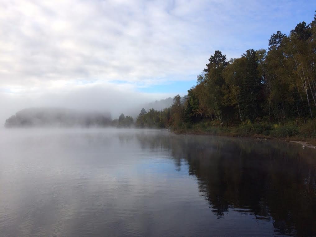
Have you noticed more of your local bodies of water steaming early in the morning? No surprise that this is the time of year when that becomes more typical. Thanks to all those wonderful long and warm summer days, bodies of water have warmed up nicely and are still retaining some of that heat. However, due to frequent overnight lows in the 30s and 40s the evaporation from lakes, rivers, ponds can actually be seen as it turns immediately into clouds of steam. Keep in mind that an air parcel can't hold as much water in a colder environment as it can in a warmer environment. With that said, as moisture evaporates from a warmer body of water and contacts colder air parcels, those colder air parcels quickly become saturated and form clouds or steam. Just like boiling water steaming on the stove, that hot liquid is MUCH warmer than the air surrounding it.
(Image courtesy: Aaron Weidner)
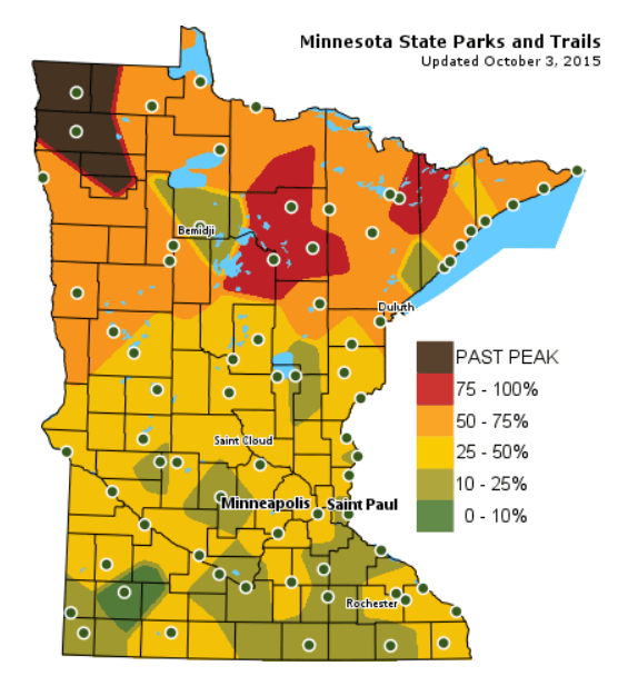
Minnesota Fall Color Report
What a glorious weekend it was to do a little fall color peeping! Take a look at how far along parts of northern Minnesota are in their fall colors! In fact, far northwestern Minnesota is already past peak, while a few pockets in the northcentral and northeastern part of the state are peaking right now!
______________________________________
"Sept-ober": Frost-Free MSP Metro Next 8-10 Days
By Paul Douglas
It's been staying milder longer; warmth extending deeper into autumn in recent years. Not every year, but factoring the random gyrations of weather, a trend is emerging. Not a much-maligned climate model, but actual thermometer readings.
Climate data since 1948 shows the median date of the first 32-degree temperature at MSP International Airport as October 7. The old rule of thumb: most Twin Cities suburbs experience their first frost the first week of October. Last year the first sub-freezing temperature was October 11. In 2013: October 21.
Gazing at the maps, with a persistent west-to-east "zonal" jet stream flow keeping the coldest Canadian air bottled up to our north, I don't see a serious metro frost through at least October 15. A longer growing season, yes, and more ragweed to annoy those of us with allergies.
A "Rex" blocking pattern, coupled with a firehose of tropical moisture from "Joaquin", dumped 2 FEET of rain on parts of South Carolina. Amazing.
Expect more 60s and a few 70s into next weekend. October remains frost, freeze and flake-free until further notice.
______________________________________
SUNDAY NIGHT: Patchy clouds. Low: 46.
MONDAY: Glimmers of mild sunshine. Winds: S 7-12. High: 67
MONDAY NIGHT: Partly cloud. Winds: S 5. Low: 52.
TUESDAY: Partly sunny, pleasant. High: near 70
WEDNESDAY: Early sun, showers late. Wake-up: 53. High: 68
THURSDAY: Showers slowly taper. Wake-up: 57. High: 67
FRIDAY: Blue sky, drying out. Wake-up: 48. High: 65
SATURDAY: Blue sky, no complaints. Wake-up: 49. High: 70
SUNDAY: Warm sun. Wow! Wak-up: 53. High: 74.
________________________________________
This Day in Weather History
October 5th
1963: Heat wave across area with 98 at Beardsley, 96 at Madison, and 94 at Elbow Lake.
________________________________________
Average High/Low for Minneapolis
October 5th
Average High: 63F (Record: 88F set in 2011)
Average Low: 44F (Record: 25F set in 1952)
_________________________________________
Sunrise/Sunset Times for Minneapolis
October 5th
Sunrise: 7:15am
Sunset: 6:46pm
*Daylight lost since yesterday: ~3 minutues & 5 seconds
*Daylight lost since Summer Solstice (June 21st): ~4 hours & 3 minutes
_________________________________________
Moon Phase for October 5th at Midnight
1.4 Day After Last Quarter

__________________________________________
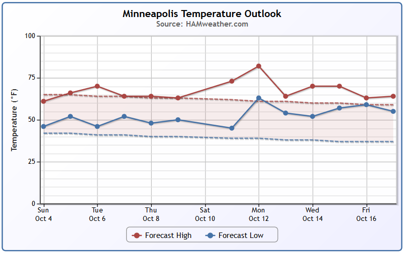
Minneapolis Temperature Trend
After several days of cool Fall weather, temperatures look to warm back to and slightly above average levels over the next several days. In fact, extended model runs suggest a warmer bias toward the middle part of the month.
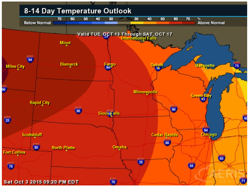
Extended Temperature Outlook
According to NOAA's CPC, the 8 to 14 day temperature outlook suggests a fairly good chance of warmer than normal temperatures across much of the Midwest by the middle part of the month.
_________________________________________
Monday Weather Outlook
High temps on Monday will be a little warmer than what we've had over the past several days as highs warm to near 70F in far Southwestern MN. However, note that feels like temperatures will still be in the low/mid 60s across much of the state with some areas across the northern part of the holding in the 50s.
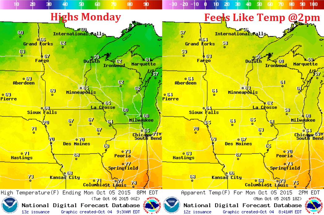
Monday Weather Outlook
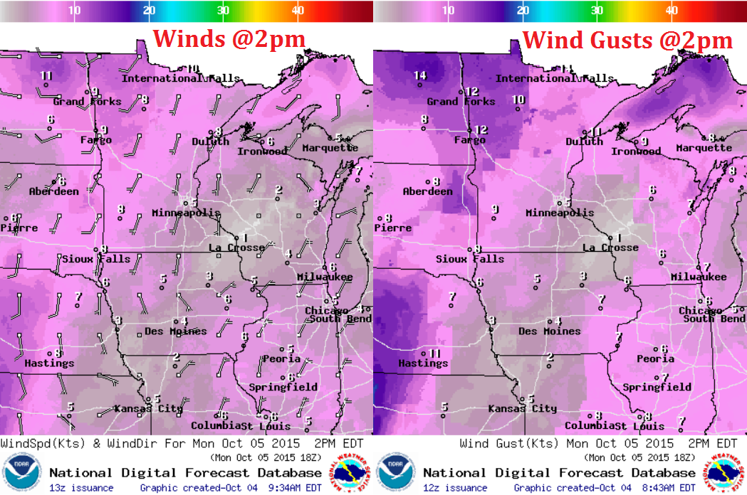
An area of high pressure located over the Hudson Bay in Canada has been responsible for our pretty idyllic October weather as of late. With that said, winds have been out of the east over the past several days, but will switch to a more southerly direction Monday. This will help to bring slightly warmer temperatures to the region over the coming days.
Friday Weather Outlook
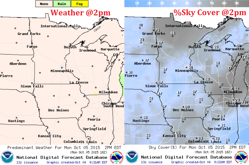
While weather conditions look to stay mostly dry on Monday, cloud cover will be quite a bit thicker, especially across the northern part of the state.
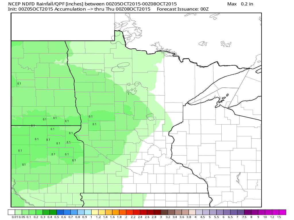
Rainfall Potential
The rainfall potential through early next week doesn't look at that impressive, but it's interesting to note that precipitation will once again be possible across parts of the state after so many dry days.
_______________________________________________
National Weather Outlook
Historic rains over the Carolinas/Mid-Atlantic States will thankfully start to ease early this week, while rainfall will be possible across the Desert Southwest. Also note that much of the middle part of the country will stay dry during the early week time frame.
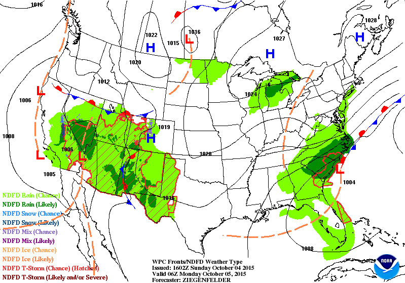
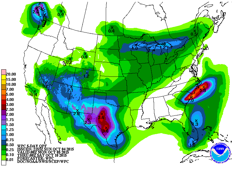
5 Day Rainfall Potential
According to NOAA's WPC, the 5 day rainfall forecast suggests the heaviest rains continuing over the Mid-Atlantic States through the early week time frame. There will also be moisture spreading throughout the Southwestern and Central U.S. as we head through the week.
___________________________________________
Significant / Historic Rains in South Carolina
Thanks to the National Weather Service out of Columbia, SC for the picture below, which was taken by a National Weather Service employee in Sumter, SC. The rainfall report from that are early Sunday was 10.42" !! There was so much water that the National Weather Service issued a Civil Emergency Message early Sunday morning:
======================
COLUMBIA SOUTH CAROLINA RELAYED BY NATIONAL WEATHER SERVICE COLUMBIA SC
715 AM EDT SUN OCT 4 2015
THE FOLLOWING MESSAGE IS TRANSMITTED AT THE REQUEST OF THE SOUTH CAROLINA EMERGENCY MANAGEMENT AGENCY COLUMBIA SOUTH CAROLINA.
SOUTH CAROLINA EMERGENCY MANAGEMENT HAS ISSUED A CIVIL EMERGENCY MESSAGE.
SOUTH CAROLINA EMERGENCY MANAGEMENT IS ASKING PEOPLE TO SAFELY REMAIN WHERE YOU ARE DUE TO THE SEVERE WEATHER AND FLASH FLOODING ACROSS THE STATE. CALL 9 1 1 FOR LIFE THREATENING EMERGENCIES ONLY.
=====================
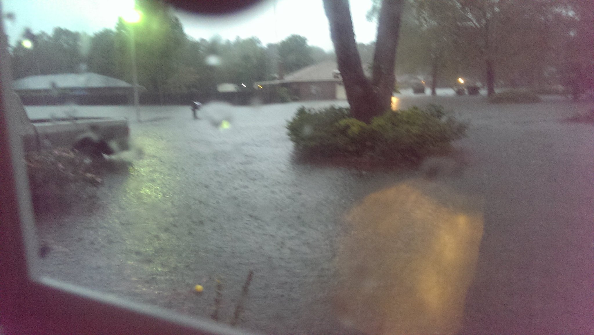
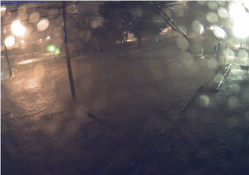
More Flooding...
Here's video from @MegMRivers:

Flooding in Downtown Columbia, SC
This was the view of downtown Columbia, SC early Sunday morning...
Historic Flooding Headlines
Thanks to Paul Douglas for compiling some of these headlines associated with the flooding:
* State of Emergency from New Jersey, Delaware and Maryland southward to Virginia and the Carolinas; as expected South Carolina hit the hardest. Flooding there is extreme, even historic, in some areas a 1-in-1,000 year flood event.
* Coastal flooding reported from New Jersey to South Carolina, especially at high tide. Water levels 2-4 feet above long term averages in some areas, driven by a strong and persistent onshore flow.
* 11.5" of rain fell on Charleston on Saturday alone, a new 24-hour rainfall record.
* Saturday afternoon's high tide in Charleston, South Carolina -- about 8.29 feet or 1.29 feet above flood stage -- was the highest measured there since Hurricane Hugo over 26 years ago. Combining with torrential rain, major flooding up to waist deep was seen in parts of the South Carolina Lowcountry.
* National Weather Service has issued a Flash Flood Emergency for Charleston and Berkeley counties. Details for Charleston:
Charleston Police: "If you believe your safety is in danger call 911, don't wait."
Charleston police: No traffic allowed onto peninsula until flooding recedes. Exceptions made for emergency personnel including hospital employees.
The President has declared a federal emergency in South Carolina. The state now qualifies for public safety assistance from FEMA.
At 3 pm, Charleston County will move to OPCON 1
Here is an explanation of OPCON and what the different levels mean.
Per Folly Beach Police Department: The island is now closed to all non-residents and non-renters.
The Dorchester County Emergency Management Department has implemented a curfew from 6 pm tonight until 7 am tomorrow. More details here.
On top of flooding, there is concern about tornado potential.
Tornado Preparedness
Waterspouts also possible.
Here are the current road closures
The Union Heights neighborhood in North Charleston is being evacuated.
The Dorchester Co. Sheriff's office has evacuated people from Summerwood subdivision in Ladson.
Coastal Flood Watch in effect from 10 a.m. through 4 p.m.; Flash flood watch continues for SC
Authorities issue health warnings after flooding causes sewage problems in North area and Sullivan’s Island (Post & Courier).
Closing and Cancellations
CPD: Use caution if you are walking as the rain may have popped off manhole covers.
Report overflowing manholes by calling 843-727-6800
There have been reports of water rescues and water entering homes.
The Charleston County Sheriffs Office will open a shelter at noon for citizens who are displaced from their homes.
Red Cross is opening a North Charleston shelter at 11 am today.
The Charleston Fire Department will also be a temporary shelter.
Charleston County Government has announced that the Al Cannon Detention Center Work Camp building is now open as a drying shelter. The work camp is located at the corner of Bridge View Drive and Leeds Avenue in North Charleston.
If roads become impassable, the Charleston Police Department has plans in place for hospital access and patient care.
CARTA has suspended all services for Saturday.
Follow Holy City Sinner on Twitter for the most up-to-date information, pictures of flooding, and more.
Mayor Riley calls rain, flooding an ‘unprecedented event’ (Charleston City Paper).
Reports: Sinkhole at Meeting Street Road and Macon Avenue. Intersection is closed; road has partially collapsed.
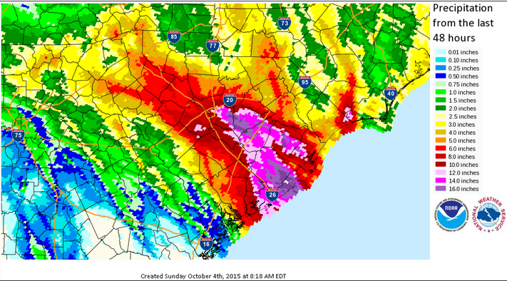
(Image courtesy: NWS Columbia, SC)
48 hour rainfall ending 8AM Sunday
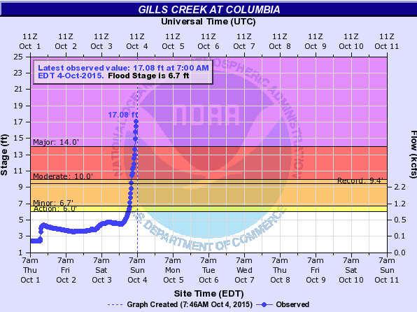
Record Flooding: Gills Creek at Columbia
The river gauge along Gills Creek at Columbia, SC showed an incredible water increase from PM Saturday to AM Sunday. In fact, this was record flooding!
"River stages at Gills Creek. Currently the gauge is reading 17.08 feet. The previous record stage was 9.43 ft on 07/24/1997. Major flooding is happening at this location as well as others around Columbia. Please stay safe! #SEFlood #scwx"
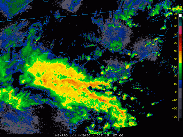
Radar: PM Saturday to AM Sunday
Take a look at the incredible radar loop below from PM Saturday to AM Sunday. Unfortunately, this intense band of heavy rain persisted over some of the same areas for a very long time leading to significant and historic rainfall.
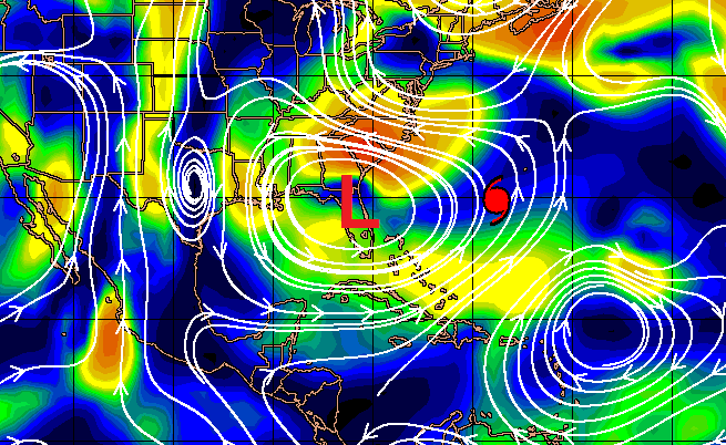
Steering Winds
The steering wind map below may help to explain why so much moisture if feeding into the Carolinas. An are of high pressure located over the the Hudson Bay in Canada in combination with an upper level low over Florida is tightening the pressure gradient over the Mid-Atlantic States. While this is drawing moisture in off of the Atlantic Ocean, the wildcard here is Hurricane Joaquin. Deep tropical moisture from Joaquin has been getting drawn into this flow allowing for exceptional rainfall tallies to occur.
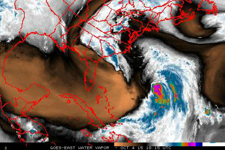
Water Vapor
Here's a look at the water vapor from early Sunday morning. While the richest moisture associated with Joaquin was well east of the Carolinas, lingering moisture from the system was still present over the Mid-Atlantic states and you can clearly see an intense band of moisture (dark blue) located over South Carolina and just east into the Atlantic.
_____________________________________
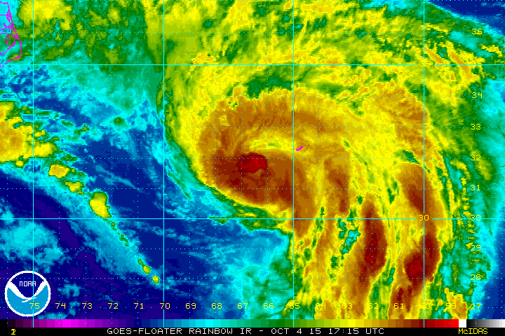
Joaquin
This was the view of Hurricane Joaquin early Sunday morning as Bermuda braced for a close encounter with a category 2 storm with winds near 100mph. Since departing the Bahama Islands, Joaquin hasn't had any major/direct impacts on any other major landmass, except helping to produce significant/historic rainfall in the Mid-Atlantic.
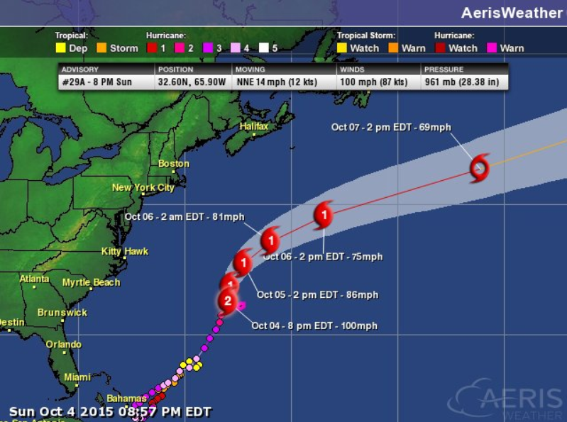
Tracking Joaquin
Joaquin's track changed dramatically from some of the initial forecasts. Interestingly, one of the only forecast models that pegged the correct track was the European model! Note that over the next few days, Joaquin will quickly sweep out into the North Atlantic.
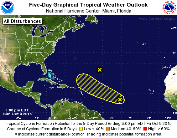
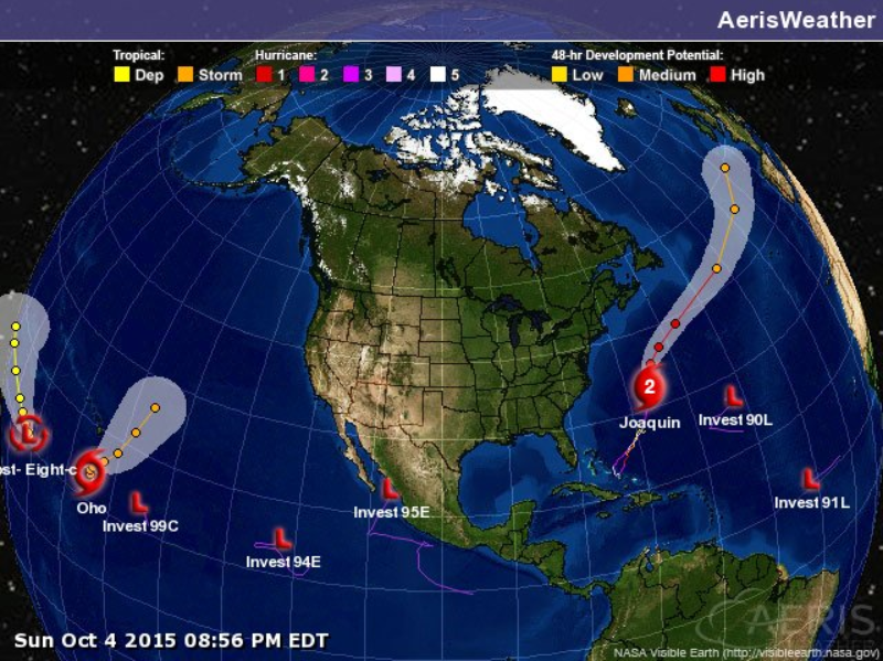
Atlantic Basin
While Joaquin continues quickly moving northeast through the Atlantic, the National Hurricane Center will continue watching a couple of waves farther east. At this time, both areas of interest have a low chance of development over the next 5 days.
Tropical Update
Joaquin is the only named storm in the Atlantic Basin right and Oho is the only named storm in the Central/Eastern Pacific Basin. Interestingly there are several other waves in the Pacific Basin that bear watching...
Thanks for checking in and have a great week ahead! Don't forget to follow me on Twitter @TNelsonWX

No comments:
Post a Comment