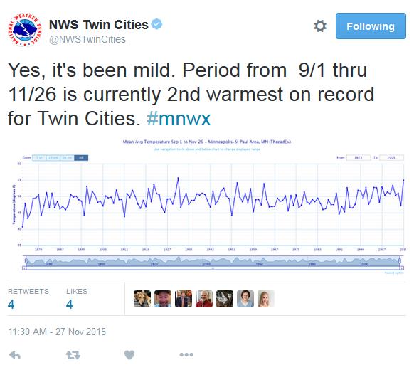
34 F. high temperature yesterday at KMSP.
33 F. average high in the Twin Cities on November 29.
38 F. high on November 29, 2014.
November 30, 2006:
Lake effect snow occurs downwind of the larger lakes in Minnesota.
Northwest winds from 8 to 12 mph accompanied an air mass in the single
digits. This moved over lakes with water temperatures near 40 degrees. A
cloud plume from Mille Lacs stretched all the way to Siren Wisconsin.
Snow from Ottertail Lake and Lake Lida reduced visibilities at
Alexandria to a few miles. Even some low clouds formed from Lake
Minnetonka and were observed at Flying Cloud Airport.
November 30, 2000:
A surface low pressure system moves into extreme southwestern Minnesota
from South Dakota. The heaviest snow reported was in the 6 to 8 inch
range, and fell in a narrow band just southwest of the Minnesota River
in and around the Canby (Yellow Medicine County) and Madison (Lac Qui
Parle County) areas. Northeast winds rising out of the Minnesota river
valley up the slopes of the Buffalo Ridge in southwest Minnesota helped
enhance snowfall amounts. The northeasterly winds between 10 and 20 mph
were responsible for producing visibilities in the one to two mile
range.
November 30, 1991: A storm dumps 14 inches of snow in the Twin Cities in about 12 hours.
November 30, 1896:
Bitterly cold temperatures are reported across Minnesota. A low of 45
below zero occurs at the Pokegama Dam. Source: Twin Cities National
Weather Service.
March-like Slush Storm;Plowable Amounts Likely
To
paraphrase Stephen King, this storm will NOT be a "carnival of
nightmare and death". Meteorological winter, kicking off the coldest 90
days of the year, starts
tomorrow
- but the maps look more like March. This will be a wet, slushy
cement-like snowfall, not prone to blowing & drifting. With
temperatures close to 32F the risk of a shoveling-induced heart attack
will be higher than usual, but many freeways will be wet and slushy.
Cold snows are more dangerous, more prone to traffic gridlock, since MnDOT chemicals don't work as well below 15F or so.
That
said, the first real snowstorm of winter will test nerves and winter
weather driving abilities. Models suggest the heaviest bands may set up
west of the Twin Cities, closer to Willmar, St. Cloud and Alexandria. I
still expect a plowable snowfall; about 4-8 inches for the metro - a
better chance of 6-10 inches about 50-90 miles west of MSP.
If you like snow get out and play in it soon, because much of it will be gone by late week as temperatures reach the low 40s.
Long range models predict a milder than average December. Looks like a trend.
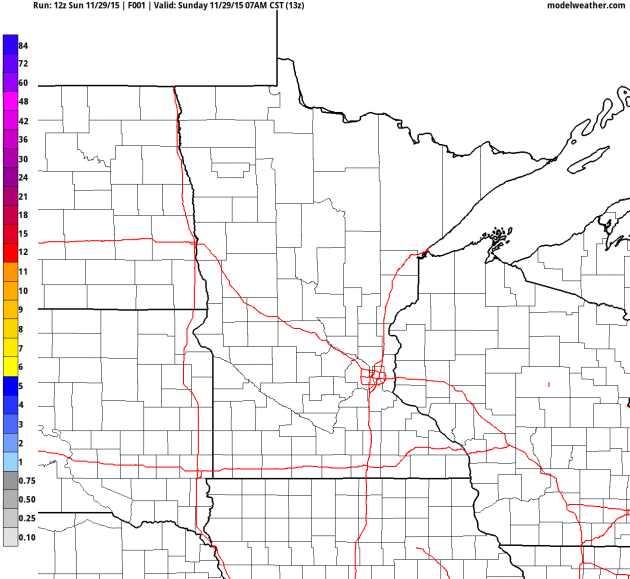
* 4 KM NAM guidance displaying accumulated snow totals courtesy of NOAA and AerisWeather.
Let It Snow.
It's almost December, we are a day away from the start of
meteorological winter. It SHOULD be snowing. Think of this as Old Man
Winter's valiant attempt to get you into the holiday spirit. NAM
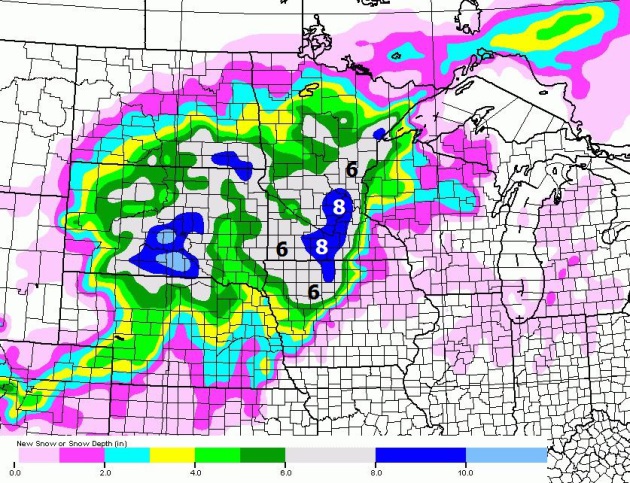
guidance above shows the best chance of 8" from the western metro
southward to Mankato and Albert Lea.
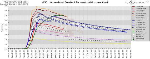
Model Spread.
The National Weather Service is predicting about 7" of snow for MSP,
the model spread for KMSP ranges from 3" to as high as 9" by Wednesday
morning. There will be compaction and settling, but totals in the 5-8"
range seem likely, with the heaviest amounts probably setting up over
the western suburbs.
Reinforcing Minnesota's Brand.
We're known for cold and snow (and our amazing lakes, of course) so
there's something vaguely reassuring about snow on the last day of
November. It's been too mild for too long. Cue winter, at least a taste.
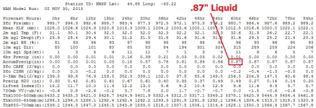
The 00z NAM prints out .87" liquid, which translates into 6-8" of
heavy, wet, slushy snow by Wednesday morning. Winds will be fairly light
through the duration of the storm, meaning little in the way of
drifting. Again, this will be more of a classic March (tournament)
snowstorm.
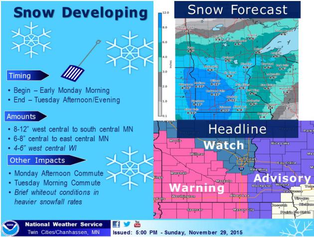
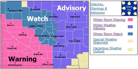
Winter Storm Watches and Warnings.
The immediate 7-country Twin Cities metro area is under a Winter Storm
Watch, meaning a potential for 6" or more of snow in 24 hours. Winter
Storm Warnings are posted just south and west of MSP, where travel
conditions will be even worse. Details from the Twin Cities NWS:
...SIGNIFICANT SNOW LIKELY MONDAY THROUGH TUESDAY...

.A STRENGTHENING STORM SYSTEM WILL MOVE NORTHEAST FROM THE
CENTRAL ROCKIES TO THE WESTERN GREAT LAKES MONDAY AND TUESDAY.
SIGNIFICANT SNOW ACCUMULATIONS ARE POSSIBLE OVER MUCH OF CENTRAL
AND SOUTHERN MINNESOTA...STARTING EARLY MONDAY MORNING OVER
SOUTHWESTERN MINNESOTA... SPREADING TO THE NORTH AND EAST...AND
CONTINUING THROUGH TUESDAY AFTERNOON...MAKING FOR A LONG DURATION
EVENT. TOTAL SNOWFALL IN EXCESS OF 6 INCHES IS EXPECTED FOR MUCH
OF CENTRAL AND SOUTHERN MINNESOTA...WITH LOCAL AMOUNTS NEAR
10 INCHES POSSIBLE. THE HIGHEST AMOUNTS WILL BE IN SOUTHWESTERN
MINNESOTA.

A WINTER STORM WARNING HAS BEEN ISSUED FOR MUCH OF WESTERN
THROUGH SOUTH CENTRAL MINNESOTA...MAINLY ALONG AND WEST OF A LINE
FROM GLENWOOD TO LITCHFIELD TO FARIBAULT TO ALBERT LEA. A WINTER
STORM WATCH REMAINS IN EFFECT FOR PORTIONS OF CENTRAL MINNESOTA
EAST OF THAT LINE TO THE WISCONSIN STATE LINE...INCLUDING THE TWIN
CITIES. A WINTER WEATHER ADVISORY HAS BEEN ISSUED FOR GOODHUE
COUNTY MINNESOTA AND ALL OF WEST CENTRAL WISCONSIN.

THIS IS A SIGNIFICANT WEATHER EVENT THAT WILL PRODUCE DIFFICULT
TRAVEL CONDITIONS. STAY UPDATED WITH NOAA WEATHER RADIO...YOUR
LOCAL MEDIA OR WEATHER.GOV FOR LATER FORECASTS AND STATEMENTS ON
THIS EVENT.
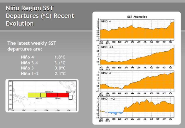
Super-Sized El Nino.
Rumors of El Nino's imminent demise aren't holding up - temperatures in
the mid-Pacific as much as 3C warmer than average; a warm signal that
may bias weather across much of North America well into the winter, even
the spring of 2016. Source: NOAA CPC.
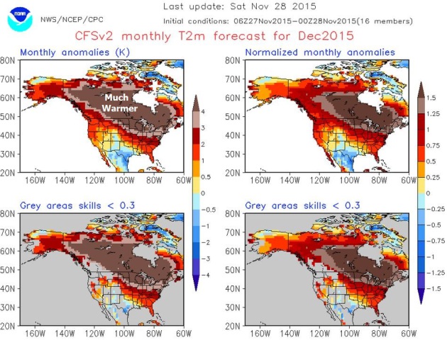
December Warmth.
When in doubt stick with persistence, which is weather-speak for "go
with the flow" or "don't buck the trends". 2015 is the warmest year ever
recorded, beating out 2014, which was the previous record. El
Nino-enhanced warmth bubbling out of the Pacific is forecast to result
in a much warmer than average December, especially northern USA and much
of Canada. Source: NOAA CPC.
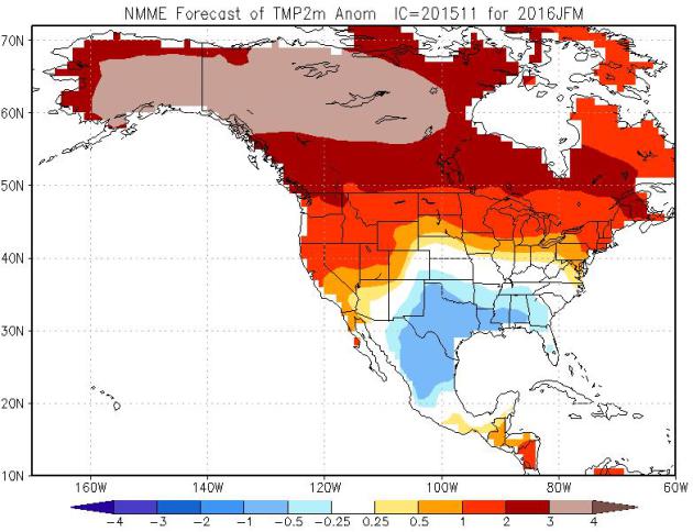
January - March Temperature Anomalies.
The southern Plains and Gulf Coast is forecast to be cooler (and
stormier) than average, but unusual warmth is forecast to persist into
the winter months, with the greatest anomalies over northern Canada and
Alaska, where temperatures are forecast to run nearly 5F warmer than
average.
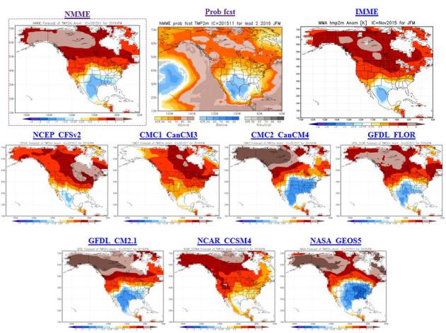
Model Consensus.
It isn't only NOAA's NMME model, but virtually ever other longer-range
climate model shows unusual, in some cases record-breaking warmth for
the northern tier of the USA and Canada into March of 2016. Source: NOAA
Climate Prediction Center.
13 Science-Backed Signs You're Smarter than Average. Sadly I didn't recognize any of the signs at this
StumbleUpon article: "
How
do you know if someone's smart? Without administering an impromptu IQ
test, there are certain clues you can use to gauge a person's relative
intelligence. We combed through decades of scientific research and
highlighted 13 surprising signs of braininess. Keep in mind, however,
that "intelligence" is often measured through tests that have been widely criticized
for putting certain social groups at a disadvantage and for minimizing
the importance of creativity. Psychologists are constantly finding
newer, more effective ways to measure cognitive ability — meaning the
signs are ever evolving..."
Every Cyber Monday Tech Deal We've Found So Far.
CNET
has a long list of possible deals if you want to do some Christmas
shopping in the comfort and privacy of your office cubicle today; here's
an excerpt: "
Cyber Monday is the time-honored tradition where savvy
shoppers skip the Black Friday crowds, and buy products from the
comfort of their couch. Where can you find a list of the products you'll
want to buy? Why, right here in this CNET post! We're tracking all the
Cyber Monday tech deals we find right here -- and perhaps a few Cyber Sunday deals as well. Check back for the latest updates..."
What's The Best Gift You've Ever Received?
Chances are it wasn't a gadget - it was something much more important.
40 leaders in various industries talk about their best gifts ever at
Quartz; here's a clip: "
Most
gifts follow a certain arc: initial excitement, followed by a gradual
fading of utility until the gift is worn out, lost, or a memory. But
great gifts are the ones that increase in value over time, the ones that
break through the noise of an ephemeral age. The gift that stands out
for me is the gift of education. It took my father seven years to make
it through a state school, and by the time I was able to go to college
at Duke, my dad told me he was going to find a way to pay for it,
despite already stretching the limits of a generous financial aid
package..."
5 Unique Winter Warming Gadgets Under $50.
TIME
has the honors, here's an excerpt of the article focused on a must-have
product that will delight you and old alike over the holidays: "
You’re
used to the finer things in life. You drive a Mazda. You drink
Budweiser Black Crown. You have an above-ground pool. So it’s no
surprise that you seem relaxed and refreshed all winter long. Why? A
warm toilet seat, of course. Let the mouth-breathing heathens be shocked
awake in the morning by their common plastic toilet seats. You prefer a
bit more refinement..."
Product Page [Amazon]
TODAY:
Winter Storm Watch Metro Area. Winter Storm Warnings central and
southern MN. Wet snow arrives - roads becoming slippery by afternoon.
Winds: E 10-15. High: 34
MONDAY NIGHT: Snow, heavy at times. Low: 31
TUESDAY: Snow tapers, 4-8" metro (more west of MSP). Winds: W 8-13. High: 34
WEDNESDAY: Flurries taper, some PM sunshine. Wake-up: 27. High: 38
THURSDAY: Mix of clouds and sun. Wake-up: 23. High: 39
FRIDAY: Partly sunny, feels like March. Winds: S 10-15. Wake-up: 26. High: 42
SATURDAY: Milder than average, patchy fog. Winds: SW 10-15. Wake-up: 32. High: 43
SUNDAY: More clouds than sun, good travel. Winds: SE 8-13. Wake-up: 32. High: 41
Climate Stories...
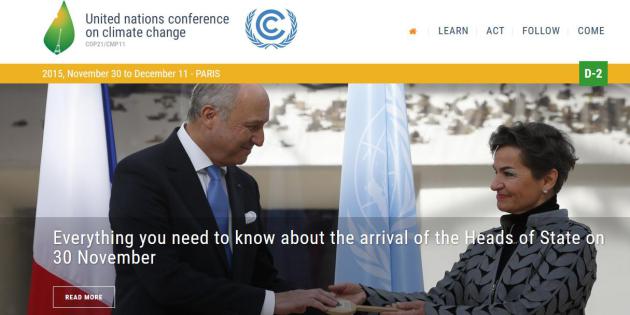
Here's What You Need To Know About the Massive Climate Summit Kicking Off in Paris. Mother Jones and
Grist have more details; here's an excerpt: "
On
Monday, roughly 40,000 heads of state, diplomats, scientists,
activists, policy experts, and journalists will descend on an airport in
the northern Paris suburbs for the biggest meeting on climate change
since at least 2009 — or maybe ever. The summit is organized by the
United Nations and is primarily aimed at producing an agreement that
will serve as the world’s blueprint for reducing greenhouse gas
emissions and adapting to the impacts of global warming. This is a major
milestone in the climate change saga, and it has been in the works for
years. Here’s what you need to know..."
Paris Climate Summit: The Climate Circus Comes to Town. The Guardian
has an amazing behind-the-scenes look at the last summit in Copenhagen.
Will December's conference in Paris yield more promising results? We
want to be hopeful, but the marriage of climate science and political
expediency means perpetual uncertainty - getting the nations of the
world to agree (on anything) is fraught with peril. Here's an excerpt:
"...
Since 1992, negotiators have gathered every year to turn that
weak promise into concrete action, meeting in cities including Berlin,
Kyoto, Buenos Aires, Marrakesh, New Delhi, Milan, back to Buenos Aires,
Montreal, Nairobi, Bali, Copenhagen, Doha, and Lima. The annual
gatherings have grown from roughly 500 participants at the first
official climate negotiations in Berlin in 1995 to sprawling jamborees –
gargantuan rotating festivals of anything remotely associated with
environmental causes or, increasingly, profit-making “green”
enterprises. The talks are conducted in English. Inside dimly lit halls,
negotiators have spent two weeks at a stretch gazing at text blown-up
into headline size by overhead projectors, doing battle over “shall” or
“should”, “commitment” or “contribution”..."
*
HotWhopper has more perspective and behind-the-scenes details of what's really happening at the Climate Summit in Paris.
Tales of a Warmer Planet.
Curt Stager takes a look at previous warm phases and wonders out loud
how the current Anthropocene will ultimately compare; here's an excerpt
from
The New York Times: "...
This
best-case scenario is troubling, but Earth history shows us that the
alternative is unacceptable. If we burn all remaining coal, oil and gas
reserves within the next century or two, we could introduce a more
extreme, longer-lasting hothouse much like one that occurred about 56
million years ago: the Paleocene-Eocene Thermal Maximum, or PETM. Unlike
the relatively mild interglacials driven by the tilt, wobble and orbit
of the Earth, the PETM fundamentally transformed the planet. Experts
speculate that it was set off by volcanism in the Atlantic Ocean,
thawing of permafrost, melting of methane hydrates, or a combination of
such factors. Whatever caused the PETM, it spewed trillions of tons of
carbon dioxide into the air and oceans. Global average temperatures
climbed 10 degrees or more, erasing cold-loving species and habitats
from the planet..." (Illustration above:
Wesley Allsbrook).
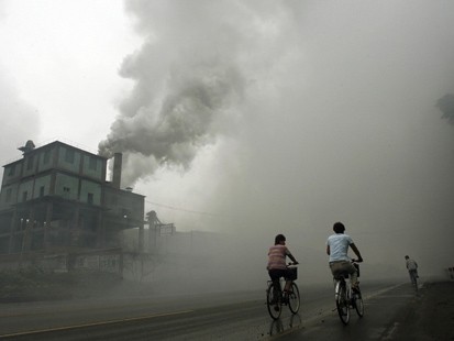
Chinese Report on Climate Change Depicts Somber Scenarios. The New York Times
takes a look at a deepening awareness of the folly of relying on dirty
fossil fuels and the implications for China; here's an excerpt: "Rising seas besieging China’s
economically vital coastal zones. Mighty feats of infrastructure, like
the Three Gorges Dam and railway in Tibet, strained by turbulent
rainfall and the melting of frozen earth. And on the Himalayan
frontiers, the risk in future decades of international conflict over
dwindling water supplies after glaciers retreat. These and other somber
scenarios are laid out in the Chinese government’s latest scientific
assessment of global warming,
released just before negotiations in Paris for a new international
agreement on climate change. “There’s deepening awareness of the gravity
of the problems,” Zhang Haibin, a professor at Peking University who was among some 550 experts who prepared the report, said in an interview..."
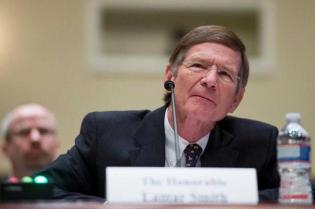
Smith's Intimidation Tactics Offensive, Dangerous. Lamar Smith's hometown newspaper, The
San-Antonio Express News
takes a dim view of Smith's grandstanding and attempted intimidation of
climate scientists in Washington D.C. - here's an excerpt of their
Op-Ed: "...
Smith told Express-News reporter Bill Lambrecht
that he has taken such an aggressive approach because the Obama
administration hasn’t been honest with the public about climate change
and is ostensibly using it as a wedge to force more regulations on
industry. He has focused on an NOAA study that found the rate of global
warming hasn’t slowed between 1998 and 2012, a finding that runs counter
to other studies. Smith has requested emails and internal
communications about the study, arguing it was politically manipulated,
and has threatened Sullivan with criminal penalties if she doesn’t
comply..."
Photo credit above:
Bill Clark /AP. "Chairman
of the Science, Space, and Technology Committee Lamar Smith, R-Texas,
is playing a dangerous game with climate change. His strategy is less
useful inquiry as it is active indimidation of the agencies and
scientists who conduct such study."
Can We Avoid Climate Apocalypse? There's still time to avoid a worst-case scenario with a 5-8C warming by the end of the century.
CNN reports; here's a clip: "
That's
when climate change starts to get especially dangerous. Nearly every
country in the world has agreed that 2 degrees of warming, measured as
an increase in global average temperature since the Industrial
Revolution, is too much to tolerate. Yet there's less agreement about
how to achieve the ambitious goal of keeping the increase below that
threshold, and how economies can switch quickly enough from dirty fuels
like coal and oil to cleaner sources of energy like solar and wind.
World leaders will meet in Paris starting on November 30 to discuss all
of this at the COP21 meeting of the UN Framework Convention on Climate Change.
Before that gets going, we invited authors, experts and activists to
weigh in on the 2-degree target. What's at stake? And how can we
actually get there?..."
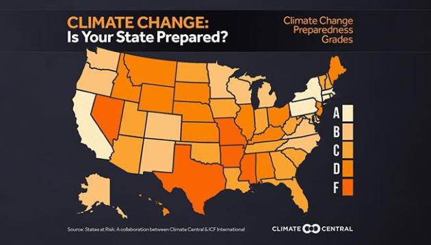
States At Risk: America's Preparedness Report Card. Minnesota, Wisconsin and Michigan score B's, in better shape - according to an evaluation from
Climate Central - than most of the USA. Here's an excerpt: "
For
over a century weather events have become more extreme, turning normal
fluctuations into long-term climate trends. Today, heavy rains
increasingly pound northeastern states, the southwest is in a long term
drying pattern, the western wildfire season is 60 days longer, rising
seas compound damaging coastal storms, and the Southeast and Gulf Coast
states are on the verge of exceeding critical heat thresholds that
seriously endanger human health..."


The GFS model has been unbelievably consistent day to day in it's predictions for temperatures. The storms will come and go, but daily temperatures are almost unanimously 32-40 for highs and 20-25 for lows. Is this because a blocking pattern similar to the North Pacific one of 2013-2014 has set up, except the El Nino version?
ReplyDeleteAnd this is for weeks on end. the 186-384 hour data, for the last 2 weeks, has been "Max temp 36-42, min temp 18-25."
ReplyDelete