30 F. high in the Twin Cities Saturday.
34 F. average high on November 28.
24 F. high on November 28, 2014.
November 29, 1991: Parts of central Minnesota receive heavy snow including a record 16 inches of snow in New Ulm.
November 29, 1835: A low of 11 below zero is reported at Ft. Snelling.
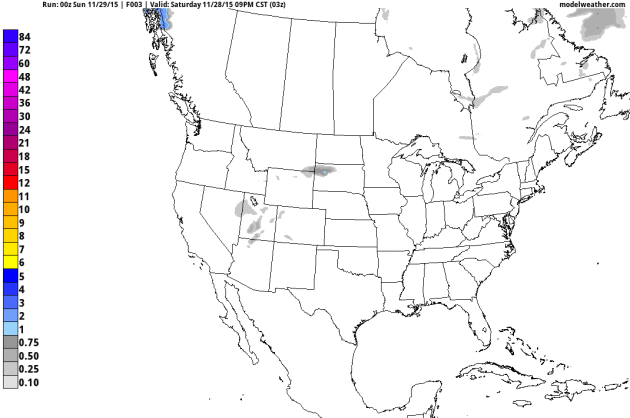
Long-Duration Snow Event Coming;Potential grows for 5-10" amounts close to home
Alert the TSA, call out the National Guard, schedule a sick day for
Tuesday
- because a wet, sloppy, long-duration "storm" is shaping up for much
of Minnesota. You remember snow, right? Yes, we are overdue for a
gasp-worthy, white-knuckle commute, school closings ticking away at the
bottom of the TV screen and flustered meteorologists comparing favorite
weather models.
On our patented scale of
nuisance-plowable-crippling this should be a long-duration (plowable)
snow event as a storm tracks southeast of MSP, keeping us on the cold
side of the system. Snow arrives during the PM hours
Monday; tapering to flurries
Wednesday morning. By then much of the metro may pick up 3-6 inches of slush; a band of 5-10 inches setting up very close to home.
This,
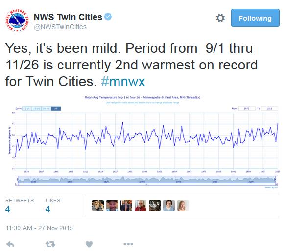
in spite of a mild El Nino pattern which is forecast to linger through
the winter. NOAA data shows Twin Cities temperatures since
September 1 have been the second warmest ever recorded. The mercury tops 40F by late week so plan a midweek romp in the snow.
It's been a long slog for Minnesota snow-lovers but patience may soon pay off. Let it snow!
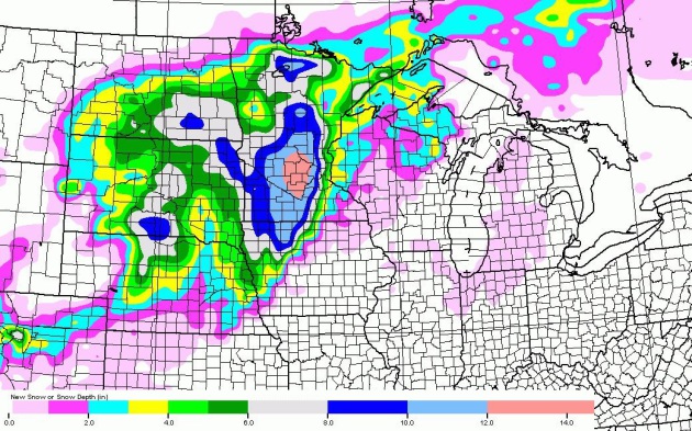
A Very Significant Pile of Slush?
Confidence levels are slowly increasing that the upcoming storm will
produce significant amounts of snow. Temperatures will be close to
freezing, meaning a heavy, wet, slushy snowfall, which increases the
risk of heart attacks, but I don't envision much blowing and drifting
with this system. It may be more like a March snow; high water content,
tough to get off driveways and sidewalks, but freeways may remain wet
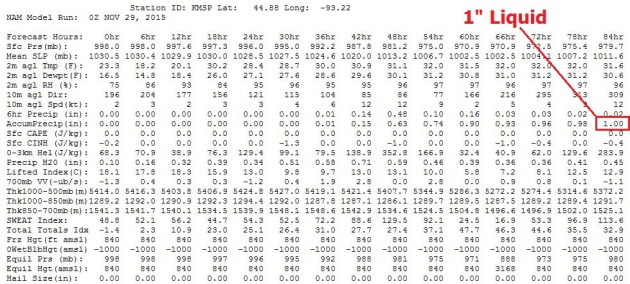
and slushy for much of this long-duration snow event. NOAA's 00z NAM
model prints out 1" liquid, which would translate into roughly 10" of
slushy accumulation (if it verifies).
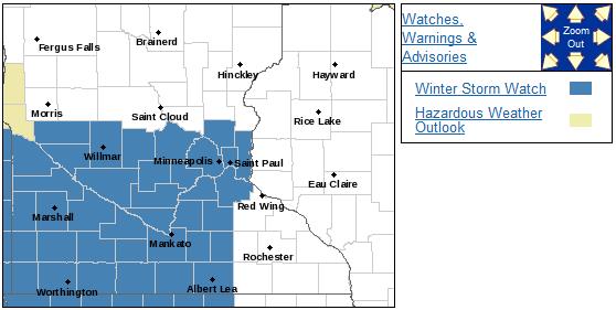
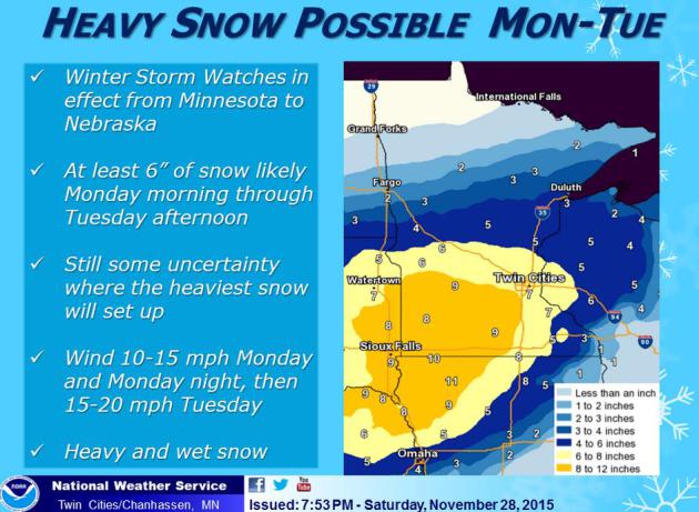
Winter Storm Watch.
NOAA has already issued a Winter Storm Watch, effective Monday and
Tuesday, calling for a potential of 6" or more of snowfall. Details from
the Twin Cities National Weather Service:
...WINTER STORM WATCH IN EFFECT FROM MONDAY MORNING THROUGH
TUESDAY AFTERNOON...

THE NATIONAL WEATHER SERVICE IN TWIN CITIES/CHANHASSEN HAS ISSUED
A WINTER STORM WATCH...WHICH IS IN EFFECT FROM MONDAY MORNING
THROUGH TUESDAY AFTERNOON.

* SNOW IS POSSIBLE FROM MONDAY MORNING THROUGH TUESDAY
  AFTERNOON.

* SIGNIFICANT REDUCTIONS IN VISIBILITY ARE POSSIBLE.

* TOTAL SNOW ACCUMULATIONS OF 7 TO 10 INCHES ARE POSSIBLE.

* THE POTENTIAL EXISTS FOR DIFFICULT DRIVING CONDITIONS...
  INCLUDING DURING THE EVENING COMMUTE ON MONDAY.

PRECAUTIONARY/PREPAREDNESS ACTIONS...

A WINTER STORM WATCH MEANS THERE IS A POTENTIAL FOR SIGNIFICANT
SNOW...SLEET...OR ICE ACCUMULATIONS THAT MAY IMPACT TRAVEL.
CONTINUE TO MONITOR THE LATEST FORECASTS.
Very Plowable.
The model solutions are all over the map, which is pretty typical with
the system still 24 hours away. The latest NAM model from NOAA shows the
heaviest amounts over central Minnesota, where over 10-12" may fall. My
confidence level is still low with all the model flip-flopping. It's
still early to pin down variations in snowfall, but there's little doubt
that this will wind up being a (very) plowable snowfall for most of the
state.
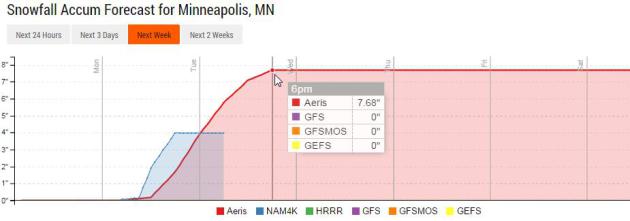
Looks Like Snow.
I'm still not convinced the upcoming snowstorm will be the exception or
the rule, but we certainly kick off December on a snowy, slushy note -
models hinting at 7+" of snow before te flakes begin to taper late
Tuesday. Source: Aeris Enterprise.
Mild Bias Continues.
No arctic plunges are brewing, at least looking out 2 weeks or so. In
fact GFS guidance has metro highs in the mid 40s two Saturdays from now
as a mild, El-Nino enhanced Pacific signal returns.
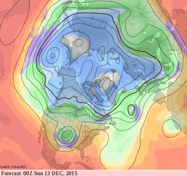
Mild Bias into mid-December, With a Side of Slush?
The GFS 500 mb upper level wind forecast valid Saturday evening,
December 12, shows a deep cut-off low over the south central USA, with
relatively mild air across most of the USA. Frankly this looks more like
mid-October than mid-December. The southerly branch of the jet is
becoming more active and Minnesota and Wisconsin may be brushed by some
of this (El Nino-enhanced) moisture.
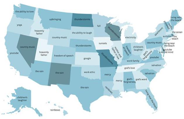
This Map Shows What People Are Most Thankful For in Each State. Minnesotans are most thankful for "fall"; Wisconsin residents most thankful for "thunderstorms". Really?
Mother Jones drills down: "
Earlier this week, Facebook's data team crunched the numbers on what users say they are most "thankful" for. The top two overall results were predictably "friends" and "family," which is heartwarming but sort of a snooze..."
What's The Best Gift You've Ever Received?
Chances are it wasn't a gadget - it was something much more important.
40 leaders in various industries talk about their best gifts ever at
Quartz; here's a clip: "
Most
gifts follow a certain arc: initial excitement, followed by a gradual
fading of utility until the gift is worn out, lost, or a memory. But
great gifts are the ones that increase in value over time, the ones that
break through the noise of an ephemeral age. The gift that stands out
for me is the gift of education. It took my father seven years to make
it through a state school, and by the time I was able to go to college
at Duke, my dad told me he was going to find a way to pay for it,
despite already stretching the limits of a generous financial aid
package..."
TODAY: Partly sunny, good travel conditions. Winds: SE 3-8. High: 35
SUNDAY NIGHT: Clouds increase. Low: 25
MONDAY: Winter Storm Watch. Snow develops, tough PM rush hour. Winds: E 5-10. High: 35
TUESDAY: Wet, slushy snow; plowable amounts; over 5" expected, as much as 8-10" in a few areas. Winds: N 10-20. Wake-up: 30. High: 34
WEDNESDAY: Flurries taper, slow clearing with slowly improving travel. Wake-up: 26. High: 37
THURSDAY: Plenty of sun, turning milder. Wake-up: 23. High: 39
FRIDAY: Patchy fog, rapid melting of snow. Winds: S 10-15. Wake-up: 27. High: near 40
SATURDAY: Mild, more clouds and fog. Winds: S 10-15. Wake-up: 29. High: 41
Climate Stories...
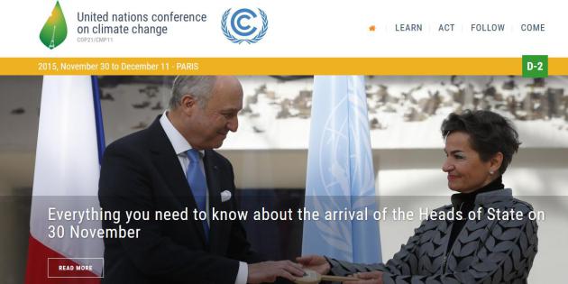
Paris Climate Summit: The Climate Circus Comes to Town. The Guardian
has an amazing behind-the-scenes look at the last summit in Copenhagen.
Will December's conference in Paris yield more promising results? We
want to be hopeful, but the marriage of climate science and political
expediency means perpetual uncertainty - getting the nations of the
world to agree (on anything) is fraught with peril. Here's an excerpt:
"...
Since 1992, negotiators have gathered every year to turn that
weak promise into concrete action, meeting in cities including Berlin,
Kyoto, Buenos Aires, Marrakesh, New Delhi, Milan, back to Buenos Aires,
Montreal, Nairobi, Bali, Copenhagen, Doha, and Lima. The annual
gatherings have grown from roughly 500 participants at the first
official climate negotiations in Berlin in 1995 to sprawling jamborees –
gargantuan rotating festivals of anything remotely associated with
environmental causes or, increasingly, profit-making “green”
enterprises. The talks are conducted in English. Inside dimly lit halls,
negotiators have spent two weeks at a stretch gazing at text blown-up
into headline size by overhead projectors, doing battle over “shall” or
“should”, “commitment” or “contribution”..."
Bill Gates Expected to Create Billion-Dollar Fund for Clean Energy. The New York Times has more details; here's an excerpt: "...
Bill Gates
will announce the creation of a multibillion-dollar clean energy fund
on Monday at the opening of a Paris summit meeting intended to forge a
global accord to cut planet-warming emissions, according to people with
knowledge of the plans. The fund, which one of the people described as
the largest such effort in history, is meant to pay for research and
development of new clean-energy technologies. It will include
contributions from other billionaires and philanthropies, as well as a
commitment by the United States and other participating nations to
double their budget for clean energy research and development, according
to the people with knowledge of the plans, who asked not to be
identified because they were not authorized to discuss the fund..."
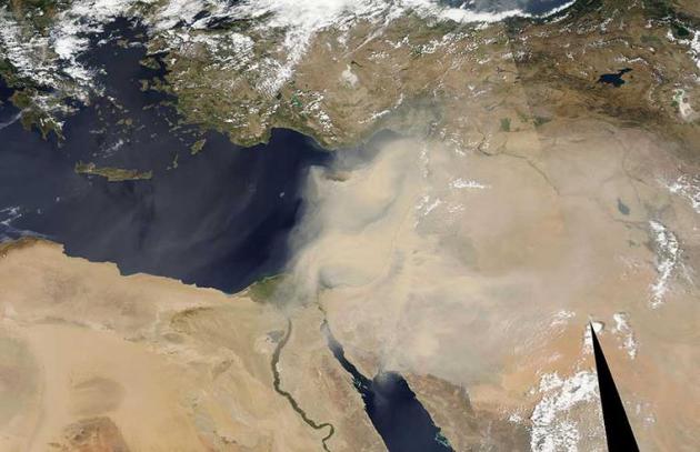
A "Climate of Insecurity": Global Warming as a "Threat Multiplier". Is
a warming (drying) climate in the Middle East and northern Africa
increasing the potential for destabilization? Here's an excerpt of an
article at
Worldcrunch: "...
Drawing a link between security
and climate change inspired mockery from some quarters. But this link
is a certainty, and a sufficiently unpleasant one that we systematically
forget it, only to see it raise its ugly head over and over again. In
March 2008, the High Representative of the European Union for Foreign
Affairs and Security Policy forwarded an unambiguous report to member
states on this very issue. Seven years after it was written, it clearly
served as an eerily accurate warning. The text said that global warming
acts as a "threat multiplier" in areas already suffering from social,
political, religious or ethnic tensions. "In the future, climate change
is likely to affect the social and political stability in the Middle
East and North Africa," the report read, pointing to "tensions related
to the management of water resources in the Jordan Valley and the
Euphrates and Tigris rivers, which are becoming scarce" and the
worsening tensions caused by rising temperatures..." (File image credit: NASA).
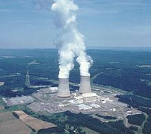
The New Atomic Age We Need.
The world is moving toward a low-carbon future, but not fast enough -
and cleaner, smaller, ultimately safer forms of nuclear energy may be
the only forms of non-carbon energy that scale fast enough, worldwide.
Peter Thiel makes a fairly compelling case at
The New York Times; here's a clip: "...
The single most important action we can take is thawing a nuclear energy
policy that keeps our technology frozen in time. If we are serious
about replacing fossil fuels, we are going to need nuclear power, so the
choice is stark: We can keep on merely talking about a carbon-free
world, or we can go ahead and create one. We already know that today’s
energy sources cannot sustain a future we want to live in. This is most
obvious in poor countries, where billions dream of living like
Americans. The easiest way to satisfy this demand for a better life has
been to burn more coal: In the past decade alone, China added
more coal-burning capacity than America has ever had. But even though
average Indians and Chinese use less than 30 percent as much electricity
as Americans, the air they breathe is far worse. They deserve a third
option besides dire poverty or dirty skies..."

No comments:
Post a Comment