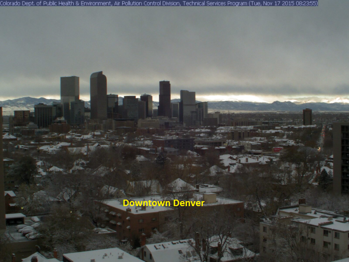
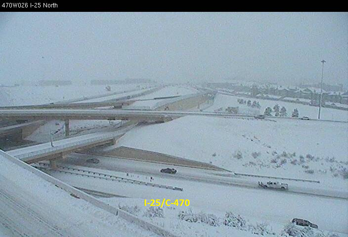
Here are a few snowy images from early Tuesday out of Denver, Colorado. The same storm system responsible for our wet weather in the Twin Cities over the last couple of days is the same storm that brought more than a foot of snow to places in the Central Rockies/Front Range earlier this week.
(Images courtesy: NWS Denver/Boulder via CDOT, Douglas County, & Colorado Air Pollution Division)

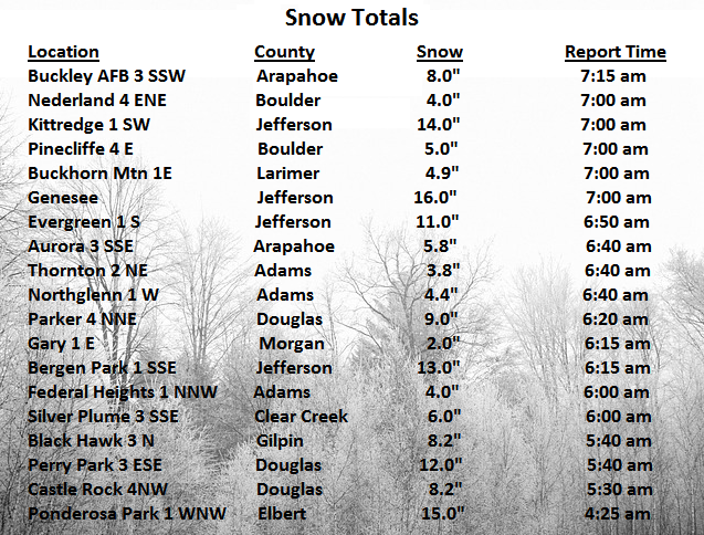
Some Colorado Snow Totals
Thanks to the National Weather Service out of Denver/Boulder for the snow reports below. Note that there were a several 12"+ amounts!!
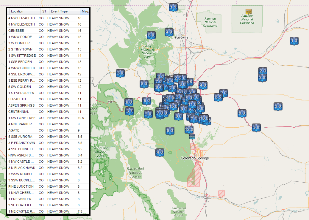
Colorado Radar Early Tuesday:
This was the radar from early Tuesday in Colorado as snow, strong winds and even blizzard-like conditions continued along the Front Range of the Rockies.

Blizzard Conditions Tuesday
Thanks to the National Weather Service out of Goodland, KS for the image below, which shows how poor visibility was in the northwestern part of Kansas early Tuesday.

_____________________________________
Damp. Temperatures take a tumble, snow up north
By Todd Nelson
My feet are wet, my umbrellas needs a break and my shovel is getting jealous. I don't think I am cut out for this wet, November weather. It doesn't seem right, does it?
Thanks to a deep trough of low pressure in the Western U.S., we've had to deal with a steady stream of moisture over the past couple of days. Precipitation values with this particular storm have been impressive for this time of the year and we're not quite done yet.
The center of the storm will pass over us today with steadier rains ending early and possibly transitioning to a wintry mix late in the day across the northern half of the state. You will definitely notice the chill in the air late tonight/tomorrow as winds pick up on the backside of the system. Enough lingering moisture combined with cold air could produce a few inches of slush in northern Minnesota through Thursday, but the Cities will state accumulation free. A quick moving system could bring shovelable snow to Iowa and southern MN Friday, I'm watching it.
No big storms developing for Turkey Day.
_______________________________
TUESDAY NIGHT: Cloudy with periods of rain. Perhaps a rumble of thunder. Winds: ESE 10-15. Low: 49
WEDNESDAY: Turning breezy and cooler. Rain/snow mix late, mainly north. Winds: SSW 10-20. High: 53
WEDNESDAY NIGHT: Windy, chance of a light rain/now mix, mainly north. Winds: W 15-20. Low: 30.
THURSDAY: Windy and much colder, snow up north. Winds: W 20-30. High: 36
FRIDAY: Hello November. Chance of light snow. Winds: NW 5-10. Wake-up: 22. High: 36.
SATURDAY: Still chilly. Mix of sun and clouds. Winds: NW 5. Wake-up: 19. High: 32.
SUNDAY: Brisk sunshine. Breezy south wind. Winds: SW 10-15. Wake-up: 18. High: 36.
MONDAY: A little warmer, nothing rough. Winds: WNW 10-15. Wake-up: 29. High: 43.
TUESDAY: Clouds thicken late. Winds: SE 7. Wake-up: 30. High: 42.
_________________________________
This Day in Weather History
November 18th
1994: 58 to 69 mph wind gusts result in isolated damage to structures across south central and southeastern Minnesota. Some of the counties included were Blue Earth, Faribault, Freeborn, Goodhue, Le Sueur, Nicollet, Rice, Steele, and Waseca.
1979: A heat wave continues in Southwest Minnesota. The temperature hits 70 degrees at Browns Valley.
________________________________
Average High/Low for Minneapolis
November 18th
Average High: 40F (Record: 68F set in 1941)
Average Low: 25F (Record: -4F set 1891)
_________________________________
Sunrise/Sunset Times for Minneapolis
November 18th
Sunrise: 7:14am
Sunset: 4:42pm
*Daylight: ~9 hours and 27 minutes
*Daylight lost since yesterday: ~2 minutes and 15 seconds
*Daylight lost since summer solstice: ~6 hours and 9 minutes
__________________________________
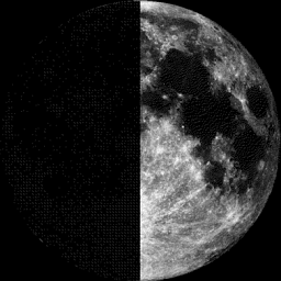
Moon Phase for November 18th
First Quarter
_____________________________________
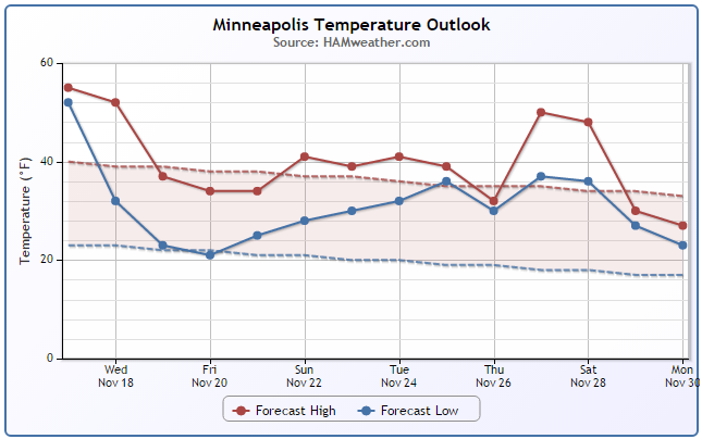
Minneapolis Temperature Trend
A blast of cooler air is on the way for the end of the week/weekend ahead. Interestingly, temperatures will be closer, if not just a little below average, but because it has been so warm as of late, this may be a bit of a shock. Good news, the extended runs are hinting at a slightly warmer temperatures by the end of the month than what it previously looked like. However, things could still change, so stay tuned!.
___________________________________
Wednesday Weather Outlook
I hope you enjoyed the mild weather while we had it because it looks like we're heading toward more normal/below normal temperatures through the end of the week. Wednesday will be the transition day as we start on a fairly mild note, but temperatures will begin to tumble late as the center of the storm begins to lift northeast into Canada.
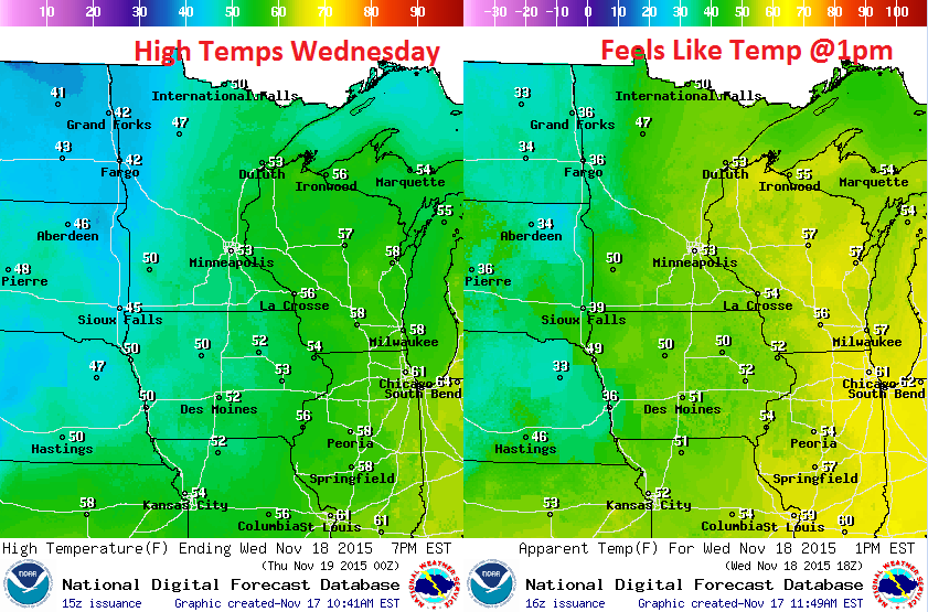
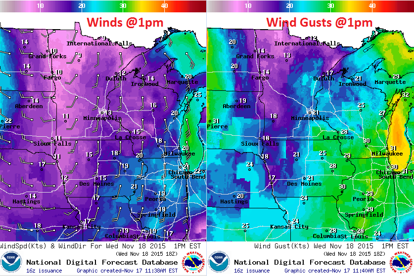
Wednesday Weather Outlook
Winds will be a bit stronger on Wednesday. They will be southerly during the first part of the day, but will begin to switch out of the WSW late and begin to increase overnight with winds gusting to near 30mph Wednesday night.
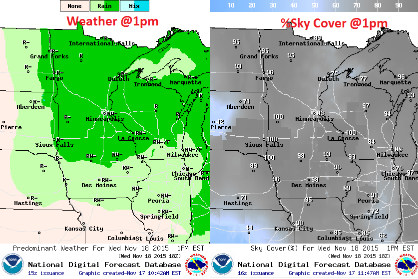
Wednesday Weather Outlook
Cloudy/soggy weather conditions continue on Wednesday as rain showers rotate around the area of low pressure. However, as temperatures begin to fall, a wintry mix can't be ruled out across the northern half of the state by Wednesday night/Thursday.
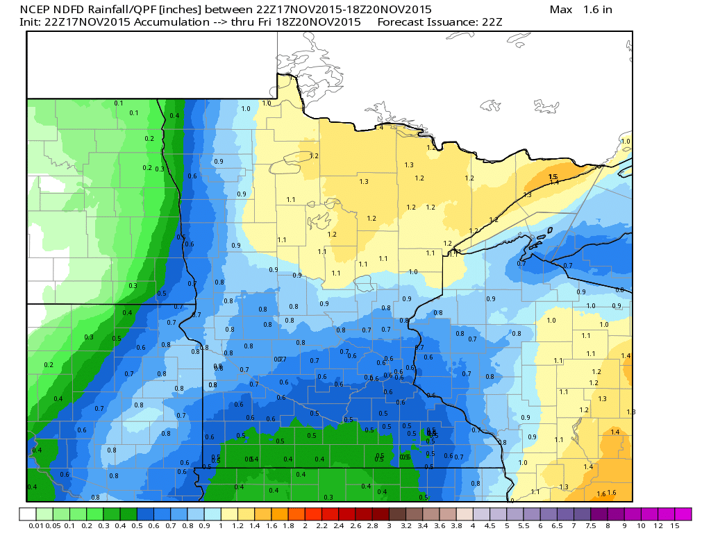
Minnesota Rainfall Potential
Here's a look at additional precipitation values from 4pm Tuesday to 12pm Friday. Note that the heaviest appears to shifting into the northern part of Minnesota.
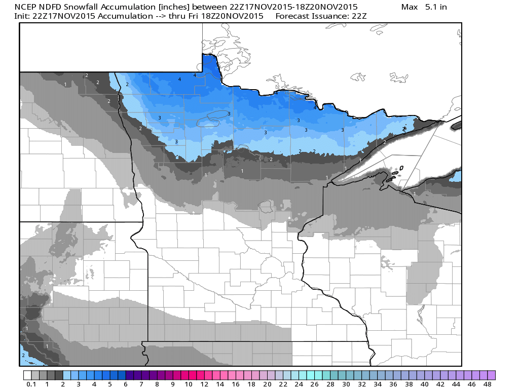
Snowfall Potential
As colder air moves in, lingering moisture will turn to snow through the end of the week. Snowfall amounts look fairly decent across the extreme northern part of the state with as much as a few inches possible through midday Friday.
___________________________________
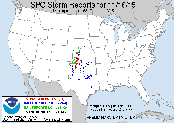
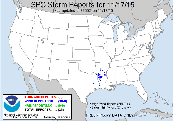
Severe Weather Monday
According to NOAA's SPC, there were nearly 150 reports of severe weather on Monday, November 16th. Nearly 40 of those reports were PRELIMINARY tornado reports from the Panhandle of Texas and Oklahoma to southern Nebraska!
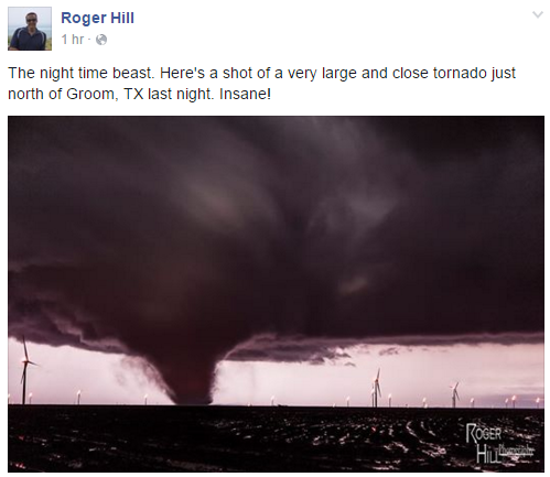
Tornado Near Groom, TX
Take a look at one of the tornadoes that was captured by the very talented forecaster/storm chaser Roger Hill from Silver Linings Tours (Storm Chasing Tours) on Monday night near Groom, TX! WOW!! Great shot Roger!!
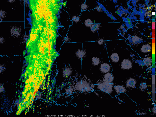
Severe Weather Reports Tuesday
According to NOAA's SPC, there were approximately 30 wind damage reports across the Lower Mississippi Valley through 5pm.
Storms Tuesday Evening
This is what the line of storms looked like on Tuesday evening as it was moving through the Lower Mississippi Valley. The line looks to continue to produce heavier rainfall through the middle and end of the week as it shifts east.
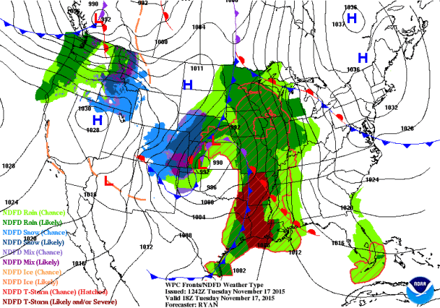
National Weather Outlook
As the storm system continues to lift northeast into Canada, heavy rain will push east of the Mississippi River Valley through the second half of the week. It appears that severe weather chances will fade, but additional heavy rain will be possible in the eastern half of the country with the heaviest found in the Southeastern U.S.. On the western/northwestern side of the storm, wind-whipped snow will develop across the northern part of Minnesota, Wisconsin and the U.P. of Michigan through the end of the week. Meanwhile, an impulse of energy developing in the Pacific Northwest will likely bring some snow accumulations to parts of the Midwest/Great Lakes by the end of the week/early weekend time frame.
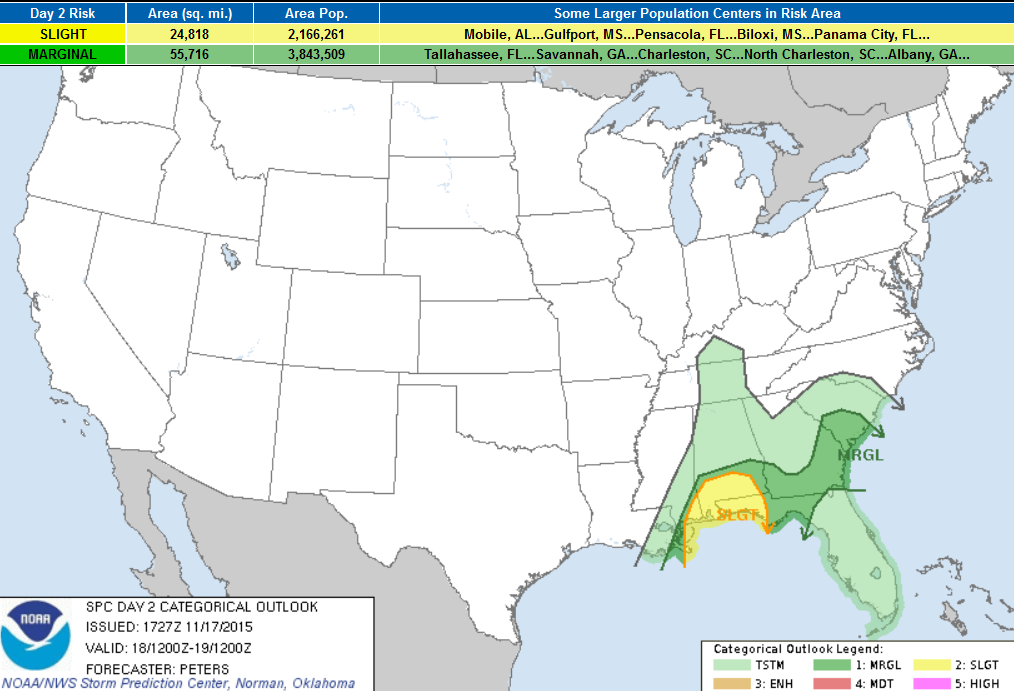
...SUMMARY...
   SEVERE THUNDERSTORMS ARE POSSIBLE ALONG PORTIONS OF THE CENTRAL AND
   EASTERN GULF COAST WEDNESDAY MORNING AND AFTERNOON.  ISOLATED SEVERE
   STORMS MAY DEVELOP WEDNESDAY NIGHT INTO EARLY THURSDAY MORNING
   ACROSS SOUTHEAST GEORGIA AND SOUTHERN SOUTH CAROLINA.

   ...SYNOPSIS...
   MID-UPPER LEVEL CLOSED LOW LOCATED OVER EASTERN PORTIONS OF THE
   CENTRAL PLAINS AND MID/LOWER MO VALLEY AT 12Z WEDNESDAY IS EXPECTED
   TO EVOLVE INTO AN OPEN WAVE AS IT TRACKS THROUGH THE UPPER MS
   VALLEY/UPPER GREAT LAKES REGION AND THEN INTO NORTHERN ONTARIO.
   MEANWHILE...A BROAD LARGE-SCALE LONGWAVE TROUGH IS FORECAST TO
   DEVELOP ACROSS THE CONTINENTAL U.S. WEDNESDAY INTO THURSDAY...WITH A
   CYCLONIC FLOW REGIME ENCOMPASSING MUCH OF THE NATION.  A FAST-MOVING
   LOW-AMPLITUDE SHORTWAVE TROUGH EXPECTED TO BE IN THE BASE OF THE
   CENTRAL U.S. TROUGH AT 12Z WILL TRACK ACROSS THE NORTHWEST GULF
   COAST AND LOWER MS VALLEY THROUGH 19/00Z...WITH THIS SHORTWAVE
   TROUGH DAMPENING AS IT MOVES TOWARD THE MID-ATLANTIC STATES
   WEDNESDAY NIGHT.
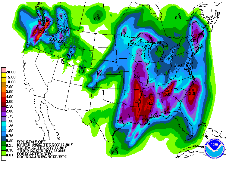
5 Day Precipitation
According
to NOAA's WPC, the 5 day precipitation forecast shows heavier rain
potential continuing east of the Mississippi Valley over the next couple
of days. Some of the precipitation could be as high as 2" to 4"+, which
may lead to areas of flooding. The other area of heavy moisture will be
found across the Pacific Northwest as another impulse of energy moves
into the area.
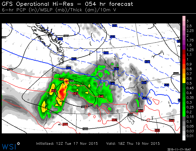
Late Week Sysetm in the Pacific Northwest
Although
it doesn' look like much, the particular system shown below by midday
Thursday may play a role is some of the first snowfall accumulations for
some across the Midwest late this week/early weekend. The sysetm below
will also continue to bring much needed precipitation to places that are
dealing with drought in the Western U.S..
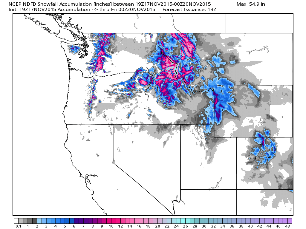
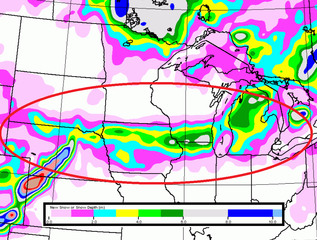
Western Snowfall Potential
The
image below suggests additional snowfall potential from midday Tuesday
to 6pm Thursday. Note that the high elevations of the Northern Cascades
and Rockies will see some of the heaviest through that time period.
Late Week Snow Potential in the Midwest
This
is that same piece of energy from the Pacific Northwest, however, this
forecast period is 6pm Friday. Temperatures will be cold enough here for
snow, some of which could accumulate at a fairly decent rain/amount.
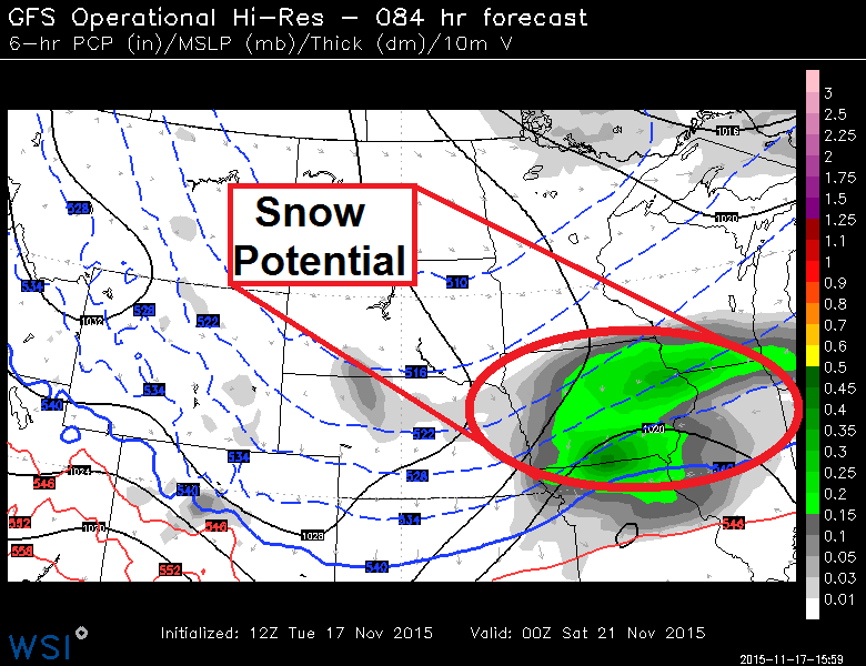
Late Week Snow Potential in the Midwest
This
late week system has been a tough one to pin down... to be honest,
forecast models have been pushing this north and south with each passing
run. The latest shows a fairly decent swath of quick
hitting/accumulating snow from parts of the Central Plains through the
Midwest to the Great Lakes late week/early this weekend. It may be just a
little too early to put an exact placement on it, so stay tuned. Just
note that some within the region below could be shoveling within a few
days!
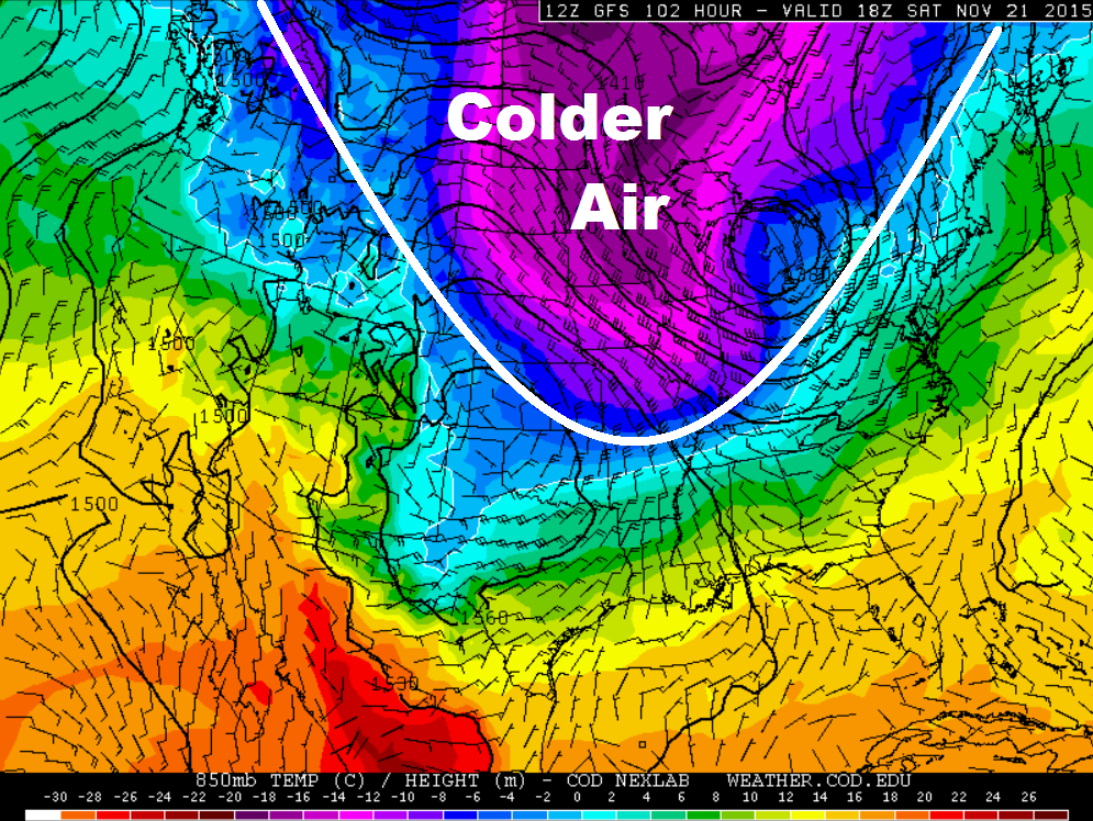
Colder Temps Ahead
Here's
a look a temperatures a few thousand feet off the ground for midday
Saturday. Note the bigger blob of colder air moving into the Midwest.
Keep in mind that this will be on the backside of the storm system that
has been plaguing much of the middle part of the country so far this
week. These cooler temperatures will roar in on a fairly stout
northwesterly breeze later this week and settle in over the weekend.
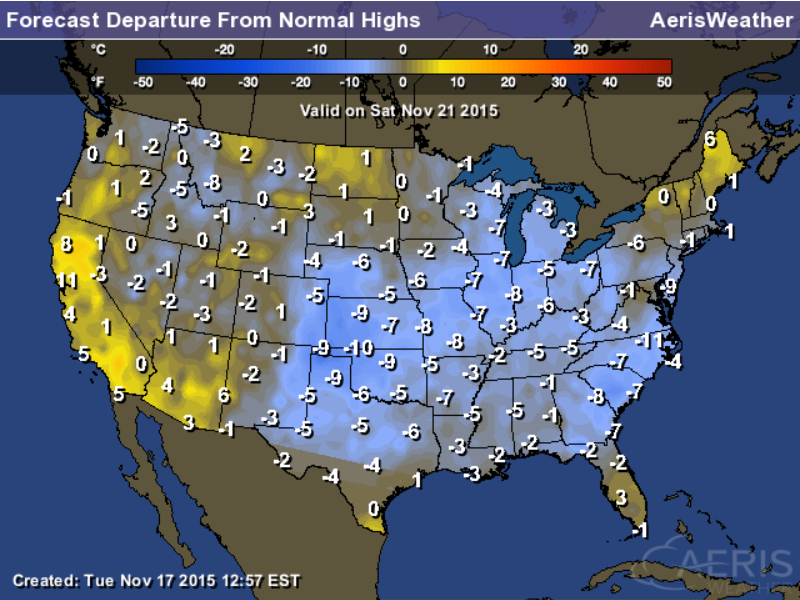
Highs From Average Saturday
As
the cold air settles in over the weekend, temperatures will take a big
hit. Instead of dealing with highs neraly 10F to 25F above average like
we had last weekend/earlier this week, temperatures will be at or below
average across much of the Eastern U.S.. In some cases, readings will be
nearly 5F to 10F below average!
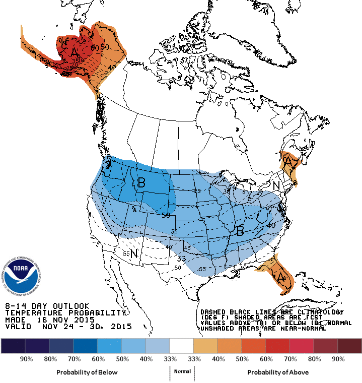
8 to 14 Day Temperature Outlook
According
to NOAA's CPC, the 8 to 14 day temperature outlook shows a decent
chance of below average temperatures heading into next week/the end of
November.
Thanks for checking in and have a great rest of your week! Don't forget to follow me on Twitter @TNelsonWX

No comments:
Post a Comment