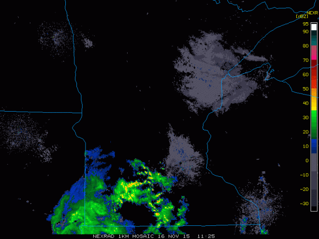
This was the radar from early Monday morning as our first round of rain moved through the southern part of the state. Interestingly, some of these showers were convective with a few heavy downpours, flashes of lightning and rumbles of thunder! Crazy to think that it is mid-November and we're dealing with thunder!!
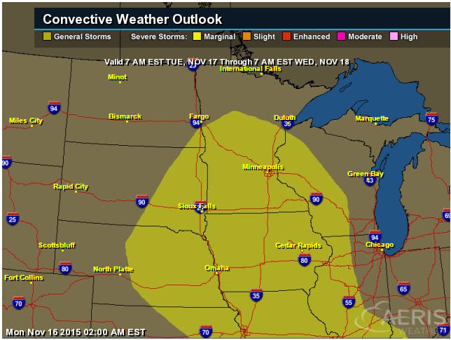
Thunder Potential Tuesday
According to NOAA's SPC, there is another chance of thunder on Tuesday for the areas shaded in yellow.
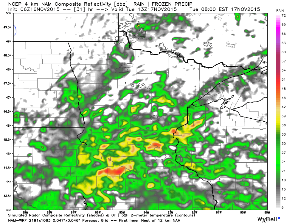
Simulated Radar 7AM Tuesday
Here's a look at the simulated radar at 7am Tuesday as our next wave of potentially heavy rain moves in across the state. This will be the second of three main waves that will be pushing through the region. The first moved through the first half of Monday, the third will move through on Wednesday.
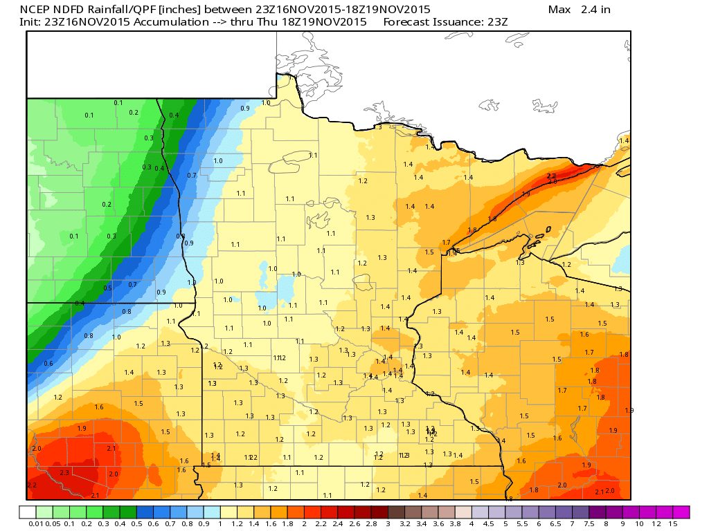
Minnesota Precipitation Potential
Total precipitation tallies (6pm Monday - 12pm Thursday) across the state could range from 1" to nearly 2" in spots.
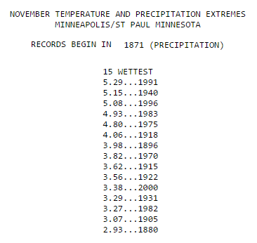
Wettest Novembers in Minneapolis
Minneapolis had 2.11" of precipitation through Sunday, November 15th, which put it in the 28th wettest November spot. With storm total precipitation forecasts nearing 1" to 2" (AM Monday - PM Wednesday) we just might find ourselves in one of the top 15 wettest Novembers in recorded history (precipitation records date back to 1871. Note that the wettest November on record for Minneapolis is just 5.29" set in 1991. Incredibly, Minneapolis saw 46.9" of snow that year, which is the most snow ever recorded during the month of November!
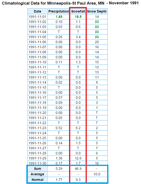
November 1991
Take a look at the crazy November back in 1991! More than 1ft. of snow fell on 2 separate days that November. The grand total snowfall that month was 46.9"!!
_________________________________
More November Puddles - Turning Colder Late Week
By Todd Nelson
Remind me again, what month is it? It sure doesn't feel like November, that's for sure! While the atmosphere seems to be suffering from an October hangover as of late, more seasonable temperatures will arrive later this week with highs dipping into the 30s. Colder temperatures will probably shock your system a bit since average temperatures are running nearly 11 degrees above average so far this month!
In the meantime, we'll have to start at 50 different shades of slate gray skies again today with more November puddles developing. Don't be surprised if you hear a few rumbles of thunder either. Storm total rainfall tallies this week could approach 1 to 2 inches in spots, which may help to put us in one of the top ten wettest Novembers on record! Keep in mind that the wettest November was in 1991 when 5.29" of liquid fell in the form of snow. Interestingly, 1991 was also the snowiest November on record with a whopping 46.9" falling that year, WOW!
Still no major snows in sight, but grease your shovels anyway. Why not.
_________________________________
MONDAY NIGHT: Cloudy with areas of drizzle early. Heavier rain and rumbles of thunder possible by early morning. Winds: SE 10-15. Low: 48.
TUESDAY: Periods of rain, rumbles of thunder?. Winds: ESE 10-20. High: 54
TUESDAY NIGHT: Cloudy with rain/thunder chances. Winds: ESE 10-15. Low: 49
WEDNESDAY: Turning breezy and cooler. Rain/snow mix late, mainly north. Winds: WSW 10-20. High: 52
THURSDAY: Windy and much colder, flakes up north. Winds: W 15-25. Wake-up: 32. High: 37
FRIDAY: Chilly breeze. Chance of light snow. Winds: NW 10-15. Wake-up: 22. High: 37.
SATURDAY: Bright sun. Extra layers needed. Winds: SW 5. Wake-up: 20. High: 34.
SUNDAY: Breezy. A little warmer. Winds: SW 10-15. Wake-up: 21. High: 40.
MONDAY: Chilly breeze. Flakes up north. Winds: WNW 10-15. Wake-up: 29. High: 39.
_______________________________________
This Day in Weather History
November 17th
1996: Six inches of snow falls in Douglas, Pope, and Stevens Counties.
1835: A strange night is observed at Ft. Snelling. Northern lights are seen over prairie fires.
________________________________________
Average High/Low for Minneapolis
November 17th
Average High: 40F (Record: 71F set in 1953)
Average Low: 26F (Record: -5F set in 1880)
________________________________________
Sunrise/Sunset Times for Minneapolis
November 17th
Sunrise: 7:13am
Sunset: 4:43pm
*Daylight: ~9 hours and 29minutes
*Daylight lost since yesterday: ~2 minutes and 17 seconds
*Daylight lost since summer solstice: ~6 hours and 7 minutes
_________________________________________
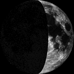
Moon Phase for November 17th at Midnight
1.0 Day Before First Quarter
___________________________________________
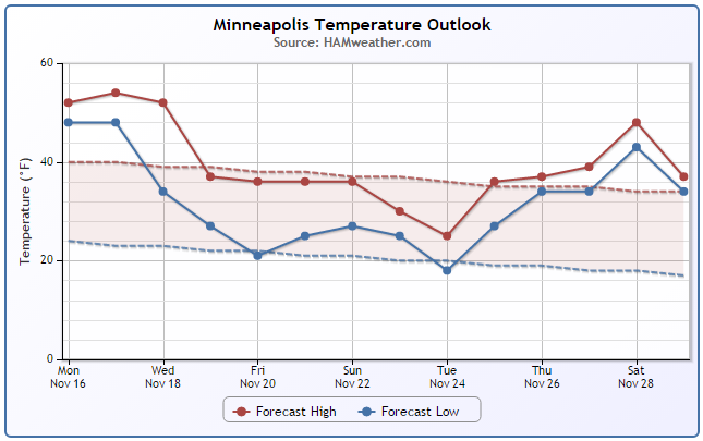
Minneapolis Temperature Trend
After several days of warmer than average temperatures, it appears that we are in for a bit of cool down by the end of the week/weekend ahead! Interestingly, we'll be closer to average during that time frame, which will feel very chilly compared to how warm it's been as of late. Extended models continue to indicate an even bigger burp of cold air a few days prior to Thanksgiving. Stay tuned!
_________________________________
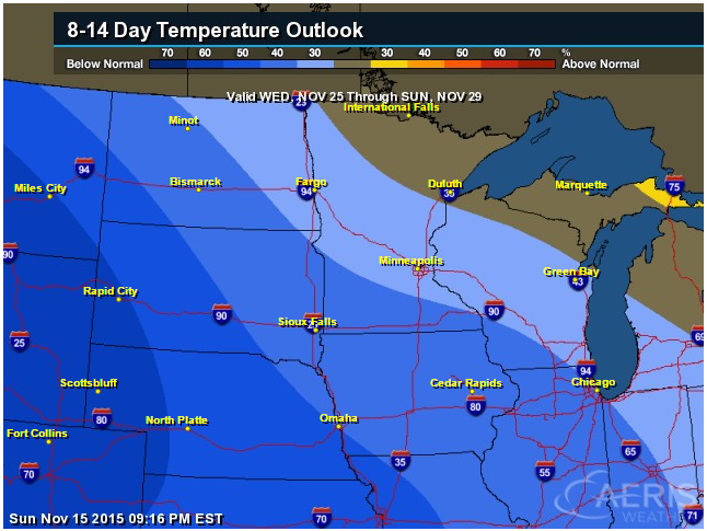
8 to 14 Day Temperature Outlook
According to NOAA's CPC, the 8 to 14 day temperature outlook shows the potential of cooler than average temperatures by Thanksgiving and the end of the month. This may be a little hard to get used to considering how warm it has been as of late.
_________________________________________
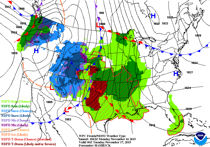
National Weather Outlook
Active weather continues across the middle part of the country as our current storm system lifts northeast toward the Upper Midwest/Great Lakes Region through midweek. Heavy rain, flooding, severe storms and blizzard potential will all be possible.
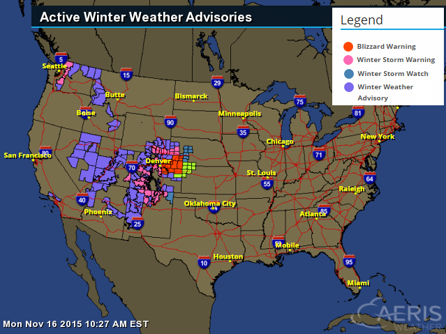
Winter Weather Headlines
There are a number of winter weather headlines across the Western U.S. in association with our current storm system. Note the Blizzard Warning in place for northeastern Colorado!
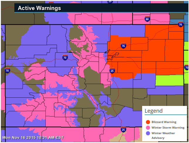
Blizzard Warning
Here are all of the latest winter weather headlines across Colorado
...BLIZZARD CONDITIONS ACROSS MUCH OF THE NORTHEAST COLORADO PLAINS TONIGHT AND TUESDAY WITH AREAS OF HEAVY SNOW IN THE MOUNTAINS...
.A STRONG WINTER STORM WILL MOVE ACROSS COLORADO TONIGHT AND INTO WESTERN KANSAS BY TUESDAY AFTERNOON. THE STORM WILL PRODUCE HEAVY SNOW IN THE MOUNTAINS AND THEN SNOW...AND VERY STRONG WINDS ON THE PLAINS. BLIZZARD CONDITIONS WILL DEVELOP IN AREAS ROUGHLY ALONG AND SOUTH OF INTERSTATE 76 LATE TONIGHT...WITH CONDITIONS IMPROVING FROM WEST TO EAST DURING THE DAY TUESDAY. WINTER TRAVEL CONDITIONS CAN BE EXPECTED IN THE MOUNTAINS BY THIS AFTERNOON.
THE WORST CONDITIONS ARE EXPECTED TO OCCUR FROM THE SOUTHERN AND EASTERN SECTIONS OF THE DENVER METRO AREA EAST TOWARDS LIMON AND AKRON. IN THESE AREAS ROAD CLOSURES ARE LIKELY DUE TO WHITEOUT CONDITIONS AND DRIFTING OF HEAVY SNOW. SOME PLACES MAY RECEIVE OVER A FOOT OF SNOW ALONG WITH WIND GUSTS TO 60 MPH. IN AREAS NORTH OF INTERSTATE 76 THE SNOW WILL BE LIGHTER...BUT THE STRONG WINDS WILL STILL CAUSE EXTENSIVE BLOWING AND DRIFTING SNOW AND HAZARDOUS DRIVING CONDITIONS.
...BLIZZARD WARNING IN EFFECT FROM 8 PM THIS EVENING TO 2 PM MST TUESDAY...
* TIMING...SNOW WILL DEVELOP THIS EVENING AND WILL BE HEAVY AT TIMES. THE HEAVY SNOW MAY LAST INTO TUESDAY MORNING IN THE DENVER AREA...WHILE ON THE EASTERN PLAINS OF COLORADO THE SNOW MAY LAST UNTIL TUESDAY AFTERNOON.
* SNOW ACCUMULATIONS...STORM TOTAL ACCUMULATIONS OF 4 TO 10 INCHES...WITH UP TO 14 INCHES IN A BAND FROM DOUGLAS COUNTY TO BETWEEN LIMON AND AKRON.
* WIND/VISIBILITY...NORTHERLY WINDS WILL INCREASE TO 25 TO 40 MPH BY LATE TONIGHT. GUSTS AS HIGH AS 60 MPH ARE POSSIBLE IN AREAS EAST OF DENVER. VISIBILITIES WILL DROP TO NEAR ZERO IN OPEN AREAS.
* IMPACTS...POOR VISIBILITIES DUE TO BLOWING AND DRIFTING SNOW MAY MAKE TRAVEL DIFFICULT OR IMPOSSIBLE IN OPEN AREAS. HEAVY SNOW AND DRIFTING WILL LIKELY BLOCK SOME ROADS. TRAVEL MAY BECOME DIFFICULT IN URBAN AREAS LATE TONIGHT AND TUESDAY MORNING.
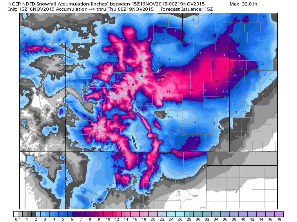
Colorado Snowfall Potential
Here's a look at how much snow could fall through 6pm Wednesday. Note how widespread the 12"+ amounts could be across the high elevations and into the Plains!
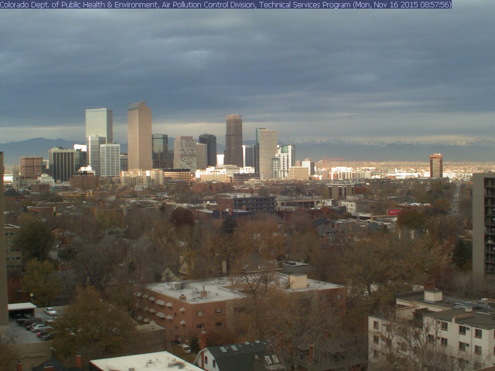
Denver, CO Webcam
This might be a neat webcam to look at when the snow really starts coming down. The image below was captured AM Monday prior to any snow falling.
See the latest view HERE:
______________________________
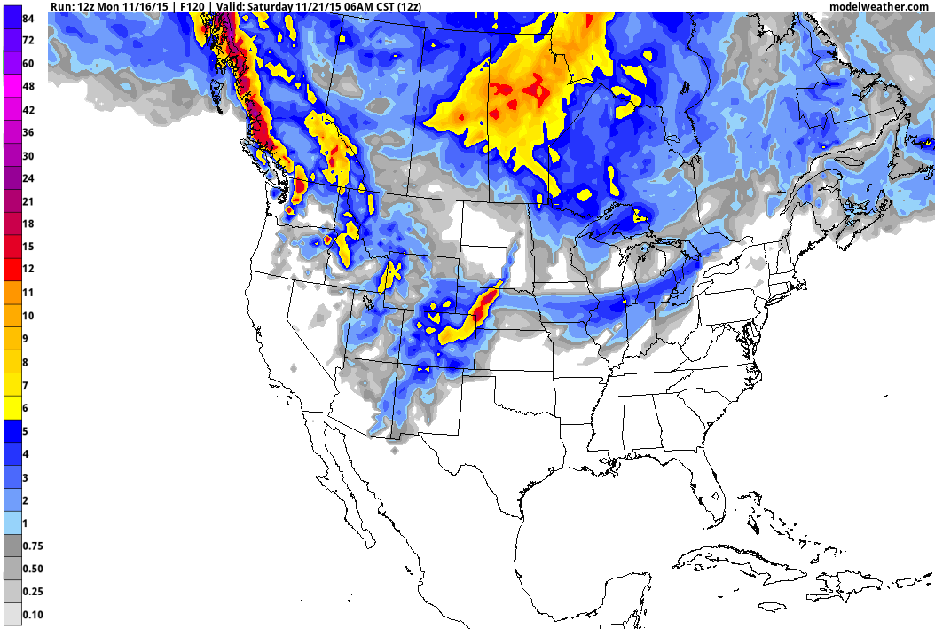
5 Day Snow Potential
Here's a look at the 5 day snowfall forecast, which shows the heaviest snow across the western U.S., but note the swath of snow across the Central U.S. into the Great Lakes Region.
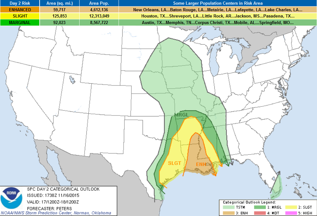
Severe Weather Concerns
A fairly potent storm system will continue to kick out strong/severe thunderstorm chances across the Lower Mississippi Valley on Tuesday. The image below suggests weather conditions midday Tuesday; note the intense band of precipitation stretching from eastern Texas to the Middle Mississippi Valley.
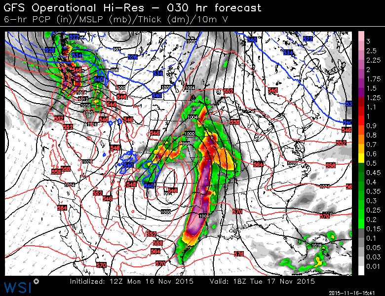
Severe Threat Tuesday
...SUMMARY...
   LINE OF SEVERE THUNDERSTORMS PRODUCING DAMAGING WINDS AS THE PRIMARY
   THREAT WILL SPREAD ACROSS THE SOUTHERN PLAINS INTO THE LOWER
   MISSISSIPPI VALLEY TUESDAY.  SEVERE STORMS WILL LIKELY DEVELOP AHEAD
   OF THE LINE OF STORMS ACROSS PARTS OF LOUISIANA INTO CENTRAL AND
   EASTERN ARKANSAS TO WESTERN MISSISSIPPI.  SOME STRONG TORNADOES AND
   DAMAGING WINDS WILL BE POSSIBLE TUESDAY AFTERNOON INTO THE EARLY
   EVENING.
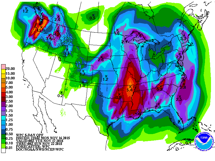
3 Day Precipitation Outlook
According to NOAA's WPC, the 3 day precipitation outlook suggests 3" to 5"+ rainfall amounts across the Central U.S., which could lead to areas of flooding. Note that some of this moisture (nearly 1" to 2"+) will make it as far north as the Upper Mississippi Valley/Great Lakes Region through Thursday.
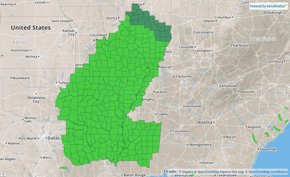
Flash Flood Watch
The National Weather Service has issued a number of Flash Flood Watches across the Central U.S. in advance of the heavy rain potential through midweek.
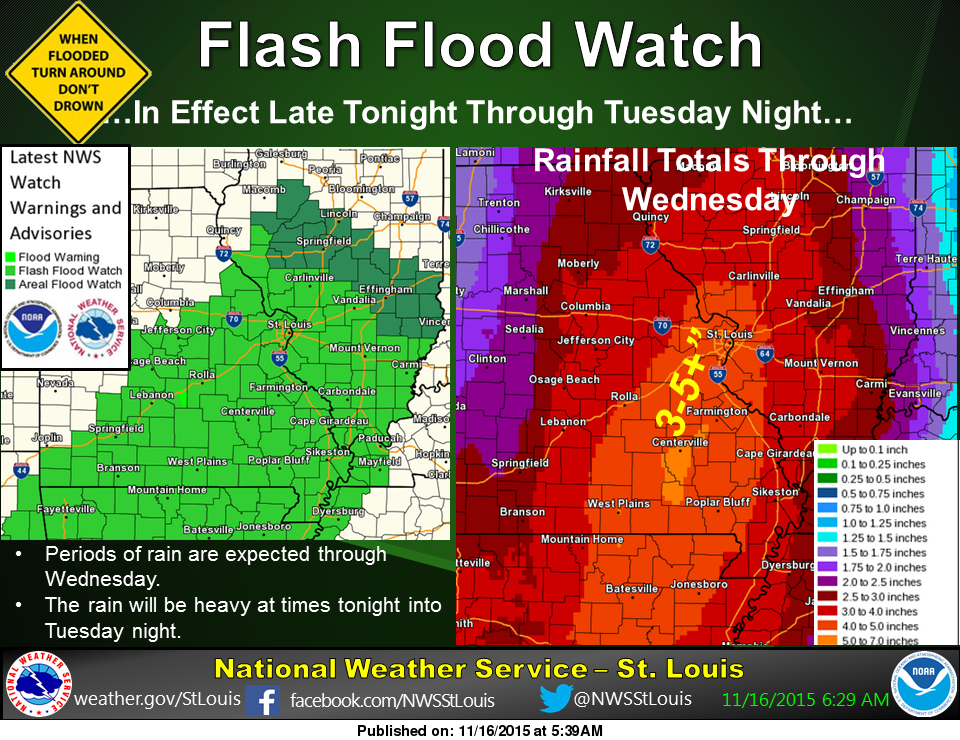
"A slow moving storm system will bring periods of rain to our area into Wednesday. The rain will be heavy at times late tonight into Tuesday night which bring widespread rainfall totals of 3 to 5 inches with locally higher amounts. A flash flood watch has been issued for much of southern and eastern Missouri as well as southern and central Illinois. Heavy rainfall will result in flooding of low lying or poor drainage areas, and dangerous flash flooding on smaller creeks and streams. Significant rises on larger streams and rivers will also be possible."
(Image below courtesy National Weather Service St. Louis, MO)
______________________________________________
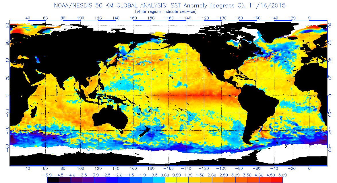
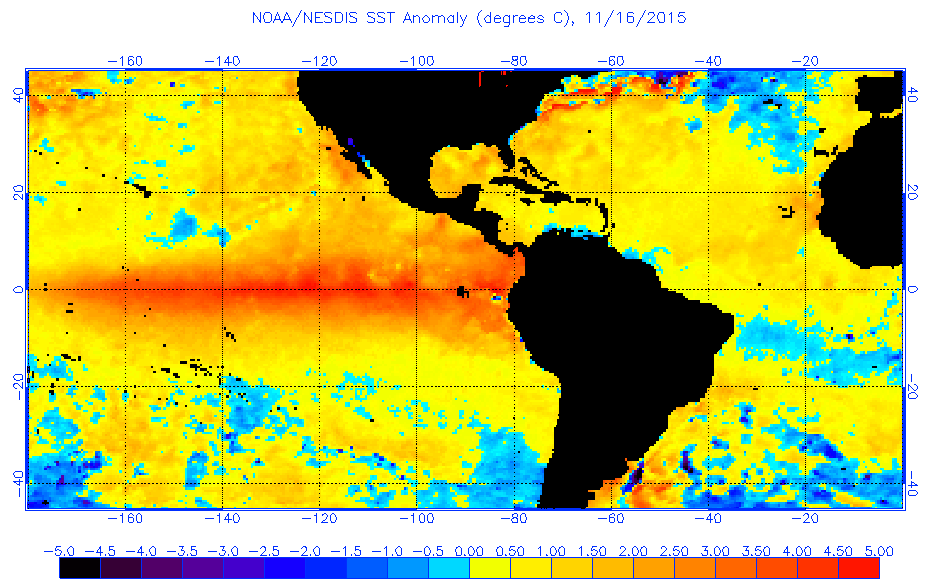
El Nino Update
Here's the latest from NOAA's CPC regarding the current and very strong El Nino ongoing in the Pacific Ocean:
Synopsis: El Niño will likely peak during the Northern Hemisphere winter 2015-16, with a transition to ENSO-neutral anticipated during the late spring or early summer 2016.
Most models indicate that a strong El Niño will continue through the Northern Hemisphere winter 2015-16, followed by weakening and a transition to ENSO-neutral during the late spring or early summer (Fig. 6). The forecaster consensus remains nearly unchanged, with the expectation that this El Niño could rank among the top three strongest episodes as measured by the 3-month SST departures in the Niño 3.4 region going back to 1950. El Niño will likely peak during the Northern Hemisphere winter 2015-16, with a transition to ENSO-neutral anticipated during the late spring or early summer 2016 (clickCPC/IRI consensus forecast for the chance of each outcome for each 3-month period)."
El Niño has already produced significant global impacts. El Niño is expected to affect temperature and precipitation patterns across the United States during the upcoming months (the 3-month seasonal outlook will be updated on Thursday November 19th). Seasonal outlooks generally favor below-average temperatures and above-median precipitation across the southern tier of the United States, and above-average temperatures and below-median precipitation over the northern tier of the United States.
See more from NOAA's CPC HERE:
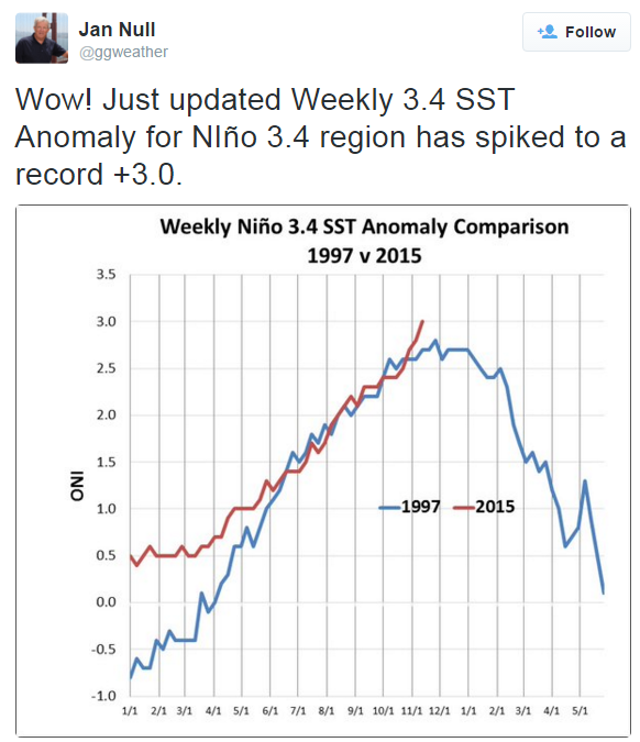
Here's an interesting Tweet from Jan Null (Twitter: @ggweather), which suggests that the sea surface temperature for Nino region 3.4 warmed to a record +3.0 ! Warmer than it was during the strong 1997 El Nino event
Thanks for checking in and have a great rest of your week! Don't forget to follow me on Twitter @TNelsonWX

No comments:
Post a Comment