I stepped outside early Wednesday to enjoy the balmy, near 60 degree warmth and sunshine while it was still avaiable, but I encountered several large puddles as well. Here's a big one in Eden Prairie after nearly 1" to 2" of rain since Monday.

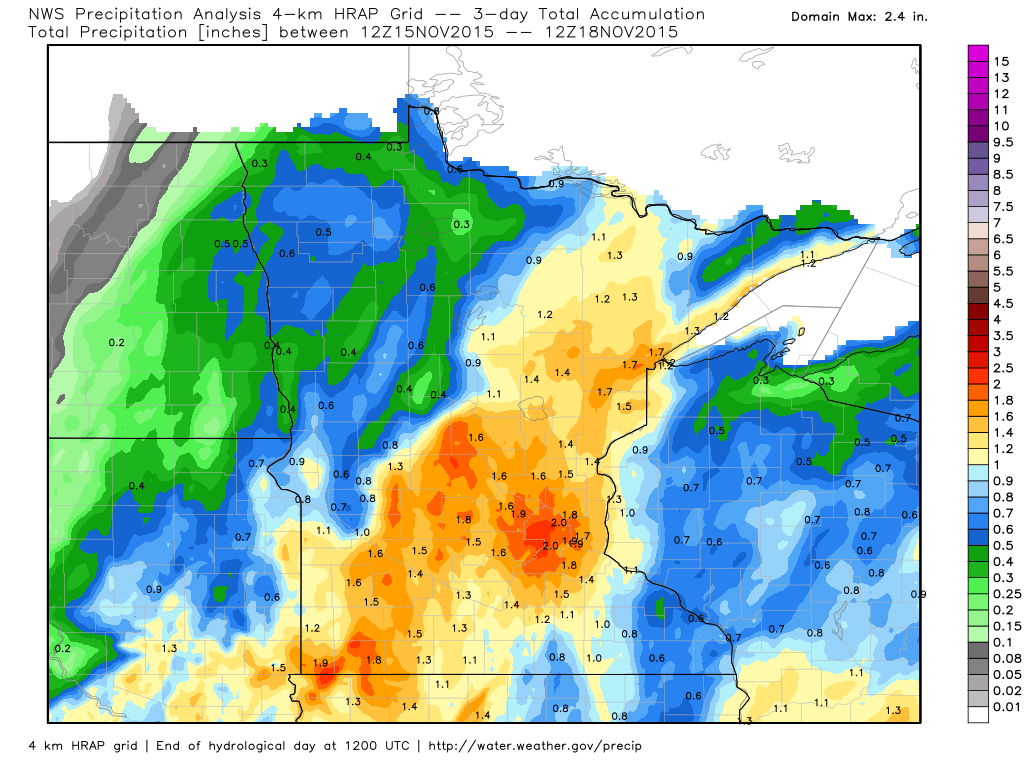
3 Day Radar Estimated Rainfall
WOW! I am very impressed with the latest mid-November storm system. According to the 3 day NWS precipitation analysis, there were several 1" to 2" amounts across the state. Interestingly, some of the heaviest looks to have fallen in and around the Twin Cities Metro!
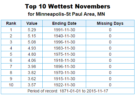
Top 10 Wettest Novembers on Record!
As of 10AM Wednesday, Minneapolis had seen 3.85" of precipitation for the month of November, which is good enough for the 8th Wettest November on record. Interestingly, note that the wettest November on record is that of 1991 when nearly 47" of snow fell!! WHEW!!
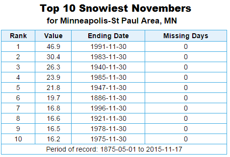
Top 10 Snowiest Novembers on Record
In case you're interested, here's a look at the top 10 snowiest Novembers on record... I think it is safe to say we won't touch any of these records this year.
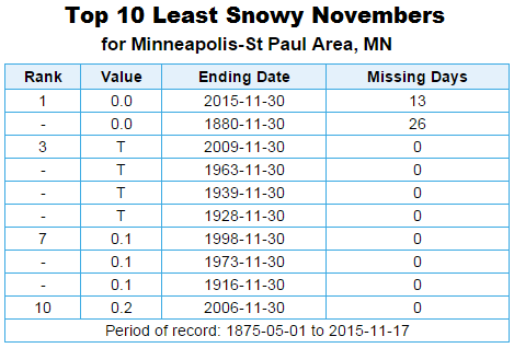
Top 10 Least Snowy Novembers on Record
Now these may be numbers that we may have to look at by the end of the month. While there may be a little snow PM Wednesday/AM Thursday, it doesn't appear to be much. Keep in mind that through November 17th, the Twin Cities has not yet seen any snow!
_______________________________________________
November Gales, Heavy Coats and Shovels(?) Return
By Todd Nelson, filling in for Douglas
If the window rattling wind didn't catch your attention overnight, maybe the near 30 degrees temperature drop will! Yesterday morning's balmy, near 60 degrees temps have dipped to near 30 degrees this morning. Keep in mind that with winds gusting to near 30mph, it'll feel more like the teens and 20s much of the day! YIKES.. grab a coat!
Colder temps and a few wind-whipped snow flakes will be featured today on the backside of a tightly wound storm system that brought us 3 days of soaking rains earlier this week. Precipitation amounts were quite impressive for November! In fact, Minneapolis had a daily precipitation record of 1.21" on Tuesday, which also helped to push us in to one of the top ten wettest Novembers on record!
While our puddles begin to fade, areas across far northern Minnesota will become more accustomed to the color white as a few inches of snow pile up today. I'm also keeping an eye on a quick moving snow event that could produce shovelable snow just south of the Cities on Friday. Stay tuned!
_________________________
WEDNESDAY NIGHT: Windy, chance of a light rain/snow mix, mainly north. Winds: W 20-35. Low: 30.
THURSDAY: Windy and much cooler! A few wind-whipped snow flakes with accumulating snow up north. Winds: W 20-30. High: 37
THURSDAY NIGHT: Partly cloudy, breezy and cooler. Winds: 15-25. Low: 21.
FRIDAY: Hello November. Clouds thicken, chance of light snow in southern MN. Winds: WNW 5-10. High: 35.
SATURDAY: AM flakies in southern MN. Chilly PM sun. Winds: NW 5-10. Wake-up: 19. High: 30.
SUNDAY: Chilly start. Brisk afternoon breeze. Winds: SW 10-15. Wake-up: 17. High: 35.
MONDAY: Mix of clouds and sun. A tad warmer. Winds: WNW 10-15. Wake-up: 26. High: 40.
TUESDAY: Clouds thicken late. Wintry mix overnight? Winds: SE 5-10. Wake-up: 27. High: 42.
WEDNESDAY: Mostly cloudy, chance of more rain. Winds: ESE 10. Wake-up: 27. High: 40.
__________________________
This Day in Weather History
November 19th
1981: Heavy snow with near blizzard conditions is observed over parts of the state. A two day total of 10.4 inches of snow was received at Minneapolis, which caused the inflated fabric of the Metrodome to collapse and rip.
1957: Snowstorm in Southeast Minnesota. A foot is dumped at Winona. Heavy crop losses.
__________________________
Average High/Low for Minneapolis
November 19th
Average High: 39F (Record: 65F set in 1930)
Average Low: 24F (Record: -5F set in 1932)
___________________________
Sunrise/Sunset Times for Minneapolis
November 19th
Sunrise: 7:15am
Sunset: 4:41pm
*Daylight: ~9 hours and 25 minutes
*Daylight Lost Since Yesterday: ~2 minutes and 12 seconds
*Daylight Los Since Summer Solstice: ~6 hours and 11 minutes
____________________________
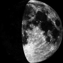
Moon Phase for November 19th at Midnight
1.0 Day After First Quarter
___________________________
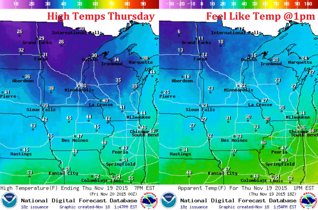
Thursday Weather Outlook
Temperatures on Thursday will be significantly colder than what we've been dealing with over the past several days. Keep in mind that these temperatures are a little closer to where we should be at this time of the year. However, thanks to a strong westerly wind, temperatures will feel like the 10s and 20s much of the day!
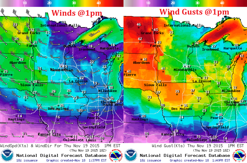
Thursday Weather Outlook
Here's a look at the winds at 1pm across the region. Note that sustained winds will be upwards of 20-30mph, while wind gusts could be up to 30-40mph+, especially across the Dakotas.
Thursday Weather Outlook
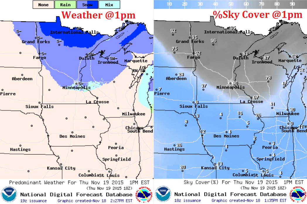
Rotating around the area of low pressure will be wind-whipped snow showers, the heaviest of which look to be across the northern part of the state. The image below suggests weather conditions and %sky cover at 1pm Thursday.
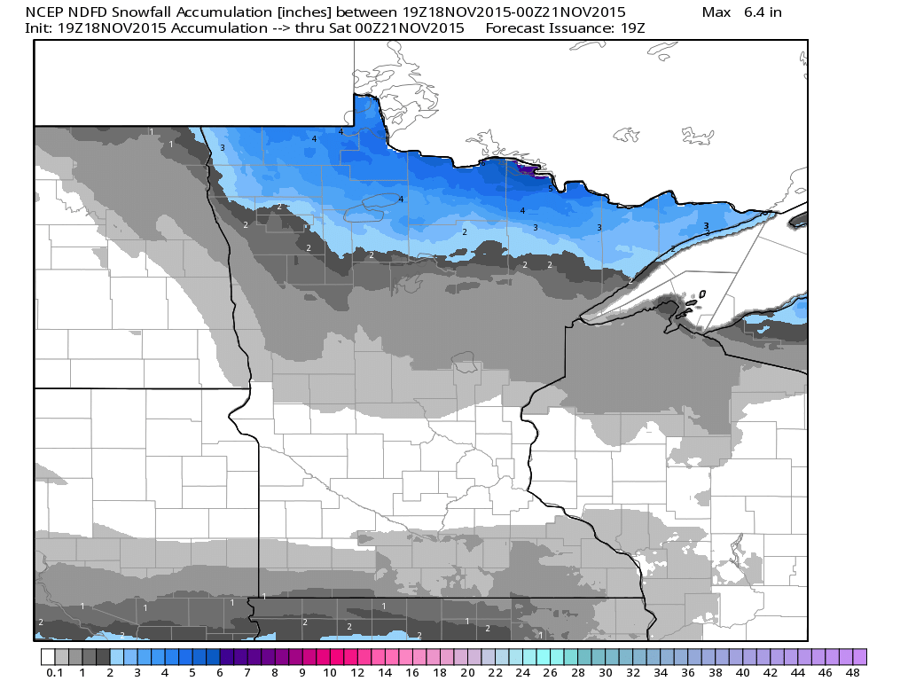
MN Snowfall Potential
According to NOAA's NCEP, the heaviest snowfall appears to be across the northern part of the state through the end of the week. In fact, some spots along the international border could see a few inches of slush by 6pm Friday. Also note the snow band across southern MN, this is the system that we'll have to watch for Friday/Saturday, though it appears the heaviest (shovelable) will fall south of the Twin Cities.
______________________________________
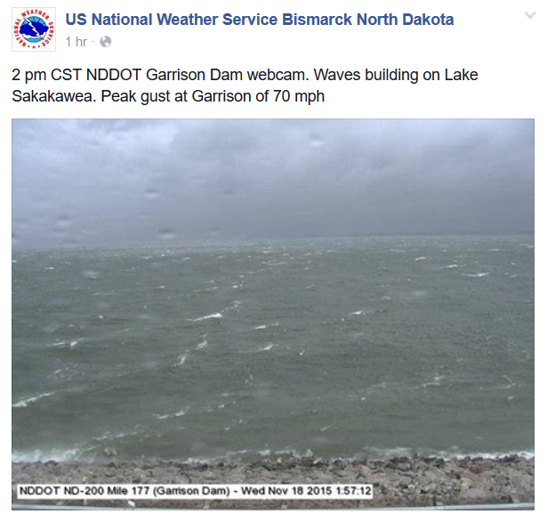
Intense Winds Wednesday
Take a look at this post from the National Weather Service out of Bismarck, ND from Wednesday. This was a NDDOT webcam from the Garrison Dam, which showed pretty inclement weather conditions as strong winds buffeted the region on the backside of the storm system as it lifted into Canada. Interestingly, there was a peak gust at Garrison of 70mph!
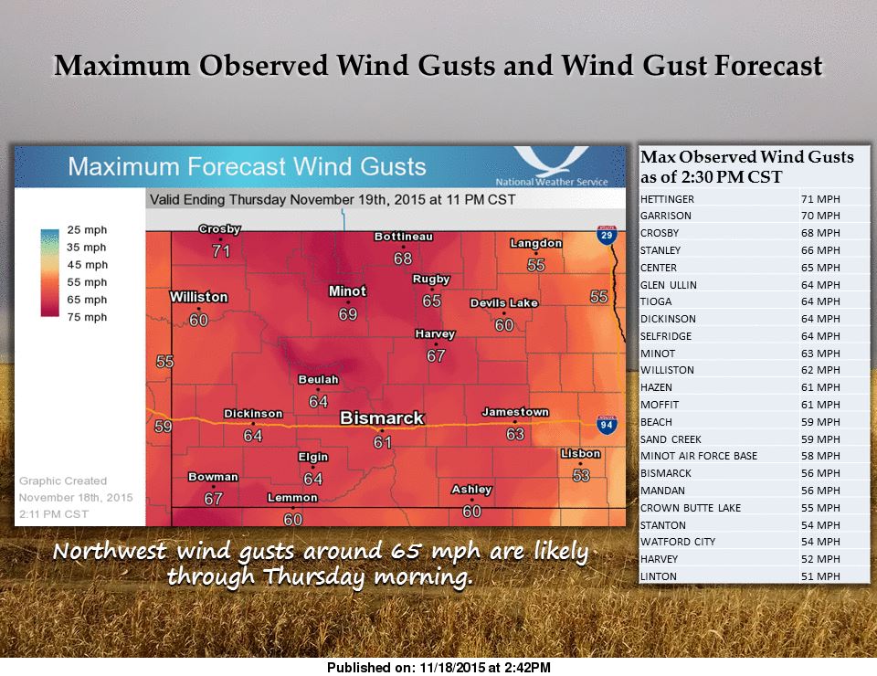
Intense ND Winds
Here are some of the strongest wind gusts observed from Wednesday across parts of North Dakota.
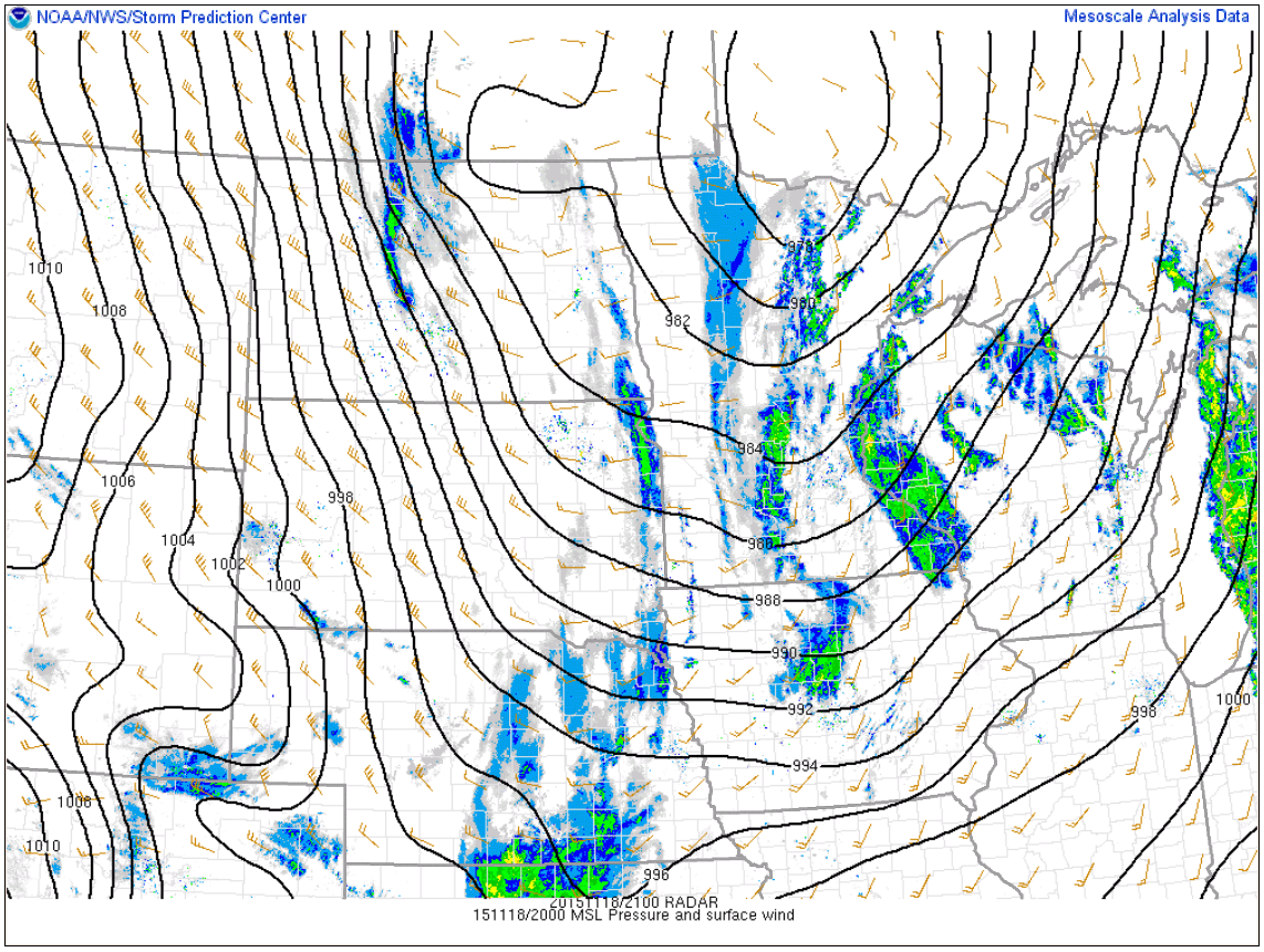
Strong Pressure Gradient
Note how tightly packed the lines of equal air pressure are across the Dakotas, this is helped to whip up significant winds across parts of the High Plains.
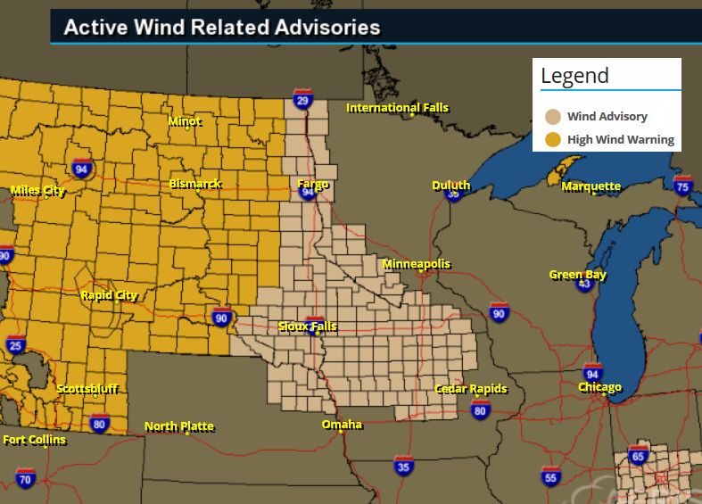
High Wind Concerns
A number of high wind warnings and high wind advisories continue into Thursday as winds gust to more than 30-40mph across parts of the region.
National Weather Outlook
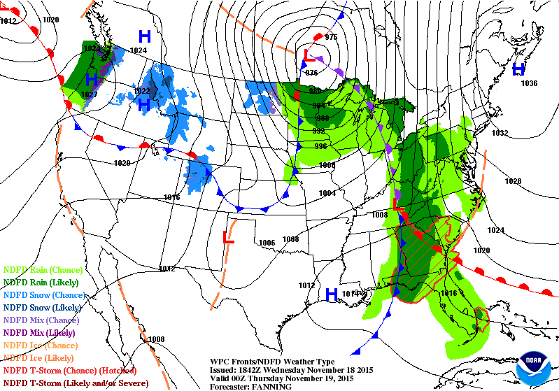
As we say goodbye to our big storm system, another weaker/faster moving system blows in later this week across parts of the Midwest. Note that temperatures look to be cool enough for mostly snow from the High Plains to the Great Lakes. Some of this snow could be quite impressive with some shovelable amounts possible in a few locations!
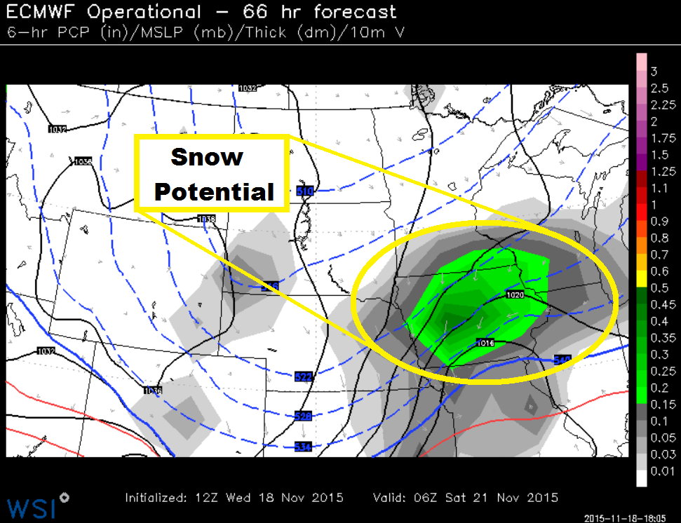
Snow Potential Friday/Saturday
Here's the quick hitting system by 12am Saturday as it moves through parts of the Midwest. Temperatures will be cold enough and there will be enough moisture for some shovelable plowable snow amounts from parts of the High Plains to the Great Lakes.
Late Week/Weekend Snow Event
A quick moving system late this week/early this weekend will have snow accumulating from parts of the High Plains to the Great Lakes Region. Some of the heaviest tallies could approach nearly 6" in spots, which could have big impacts on traveling from Sioux Falls, SD to near Milwaukee, WI.
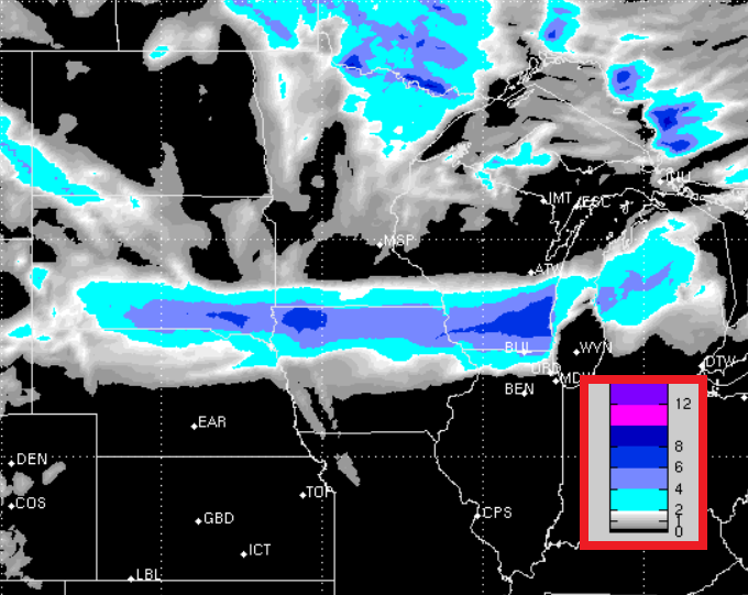
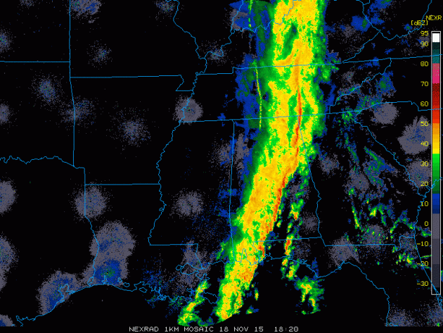
Heavy Rain, Flooding and Severe Storms Wednesday
Take a look a the line of heavy rain and storms from midday Wednesday. Note the line of stronger storms on the leading edge of the heavier rain, these were some of the strong to severe storms that popped up and produced wind damage and even some tornadoes.
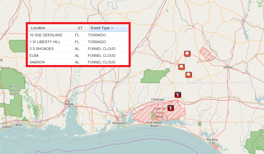
Tornado Reports Wednesday
As of early/mid afternoon Wednesday, there were 2 tornado reports near the Eglin Air Force Base in the Panhandle of Florida. Also note that there were a few funnel cloud reports in southern Alabama.
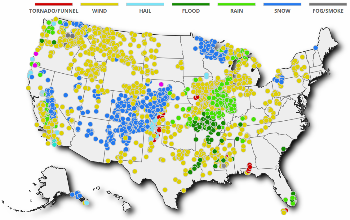
Storm Reports From November 11th to November 18th
It has been a very active week with a number of wind, snow, and severe weather reports across much of the nation. Take a look at all the weather reports over the past 7 days.
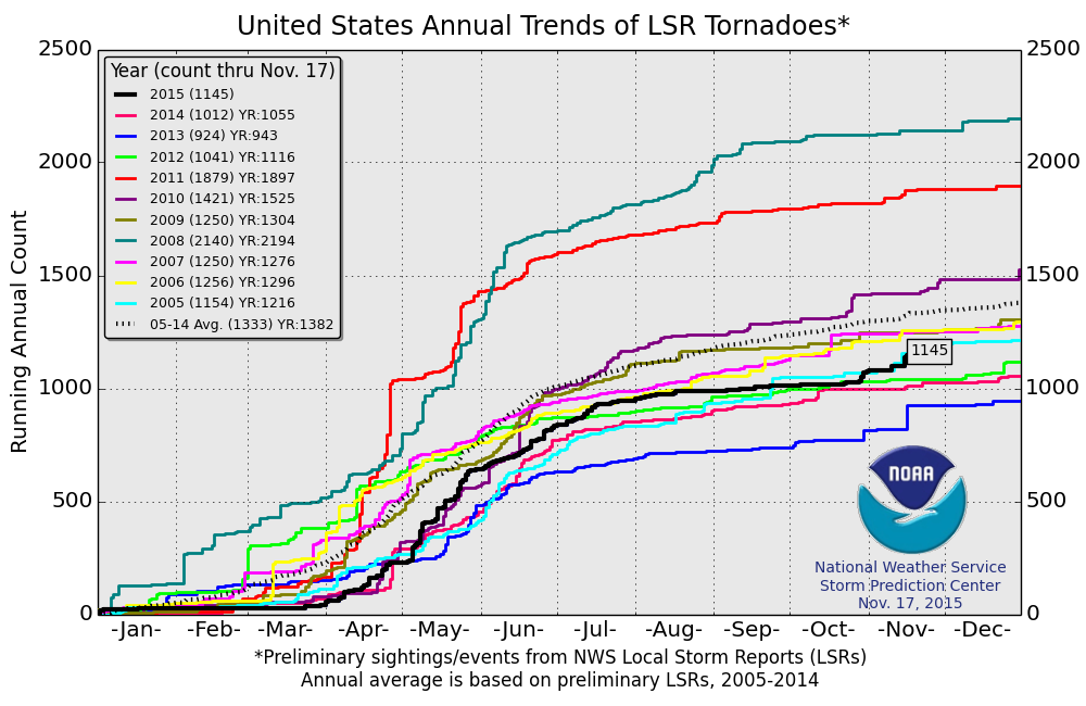
2015 PRELIMINARY Tornado Reports
According to NOAA's SPC, the 2015 PRELIMINARY tornado count through November 17th suggests that there have been nearly 1,150 tornadoes so far this year! This is a little below the 2005-2014 short term average of 1,333. However, note that this is the most tornadoes we've seen since 2011!
Thanks for checking in and have a good rest of your week/weekend ahead! Don't forget to follow me on Twitter @TNelsonWX

No comments:
Post a Comment