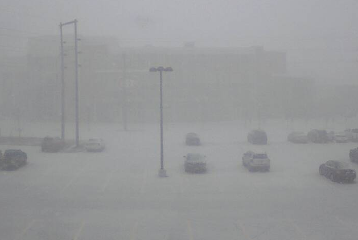
A quick hitting snow burst went through central Minnesota on Thursday morning, which created a mess for travelers/commuters in those areas. This is what the St. Cloud State University Campus looked like around 8AM Wednesday!
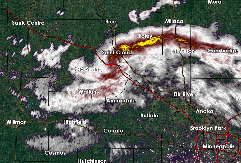
Radar ~8AM Thursday
This is what the radar looked like around 8am Thursday, note the yellow coloring near St. Cloud. This was the burst of heavy snow that brought
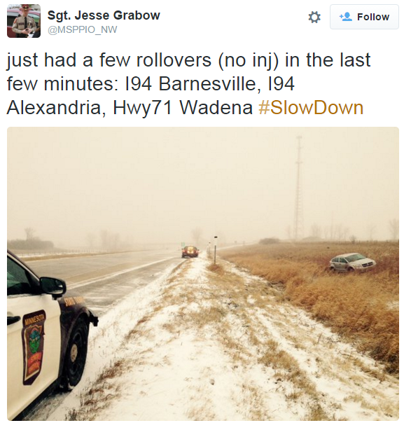
Several Accidents Thursday
Thanks to KVSC 88.1FM for the picture below near Rice, MN. Several roads in central Minnesota were glaze ice after the quick burst of snow that moved through Thursday morning.
See more from the KVSC Facebook page HERE:

More Snow for the Midwest
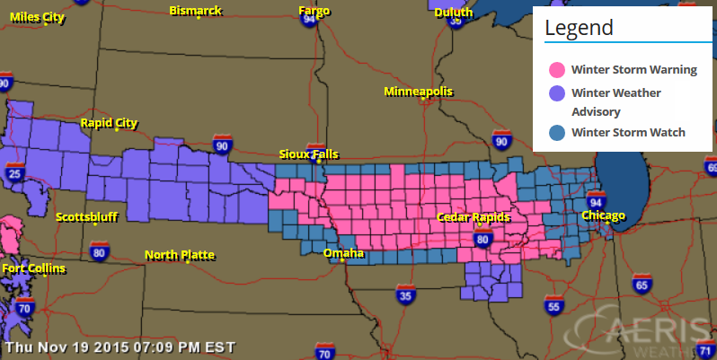
The National Weather Service has issued a Winter Storm Watch for part of the Midwest from Friday to Saturday. The heaviest snowfall accumulations will be found in a very narrow band within the watch area, but some spots could see as much as 6" to 10"!
...WINTER STORM WARNING IN EFFECT FROM 10 AM FRIDAY TO 6 AM CST
SATURDAY...

THE NATIONAL WEATHER SERVICE IN DES MOINES HAS ISSUED A WINTER
STORM WARNING FOR HEAVY SNOW...WHICH IS IN EFFECT FROM 10 AM
FRIDAY TO 6 AM CST SATURDAY. THE WINTER STORM WATCH IS NO LONGER
IN EFFECT.

* TIMING...SNOW IS EXPECTED TO BEGIN ACROSS THE AREA DURING THE
  LATE MORNING TO EARLY AFTERNOON HOURS THEN CONTINUE OVERNIGHT.
  THE HEAVIEST SNOW WILL OCCUR FROM MID AFTERNOON THROUGH MID
  EVENING.

* STORM TOTAL SNOW ACCUMULATIONS...6 TO 10 INCHES EXPECTED BY
  SATURDAY MORNING.

* WINDS/VISIBILITIES...VISIBILITIES IN SNOW MAY DROP TO ONE
  QUARTER MILE AT TIMES. WINDS OF 15 TO 25 MPH FRIDAY NIGHT MAY
  PRODUCE BLOWING AND DRIFTING SNOW...AND ALSO HELP CONTRIBUTE TO
  REDUCED VISIBILITIES.

* IMPACTS...THE COMBINATION OF SLUSHY AND SNOW COVERED ROADS WILL
  LEAD TO HAZARDOUS TRAVEL CONDITIONS...INCLUDING DURING THE
  FRIDAY EVENING COMMUTE. TRAVEL CONDITIONS WILL LIKELY BECOME
  TREACHEROUS AT TIMES. BE SURE TO USE CAUTION AND USE YOUR WINTER
  DRIVING SKILLS.
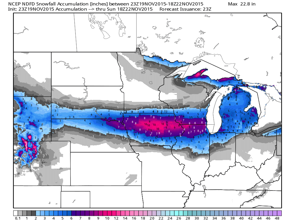
Midwest Snow Potential
Here's a look at snow totals through midday Sunday. Note that the heaviest appears to be across the central/northern part of Iowa with near 10" amount possible.
_________________________________________
Giving in to colder temps - Plowable snow south
By Todd Nelson, filling in for Douglas.
BRR! There went one shoe. I am trying to figure out when the other will drop.
Get this, through November 18th, the average temperature in Minneapolis was running nearly 12 degrees above average, good enough for the second warmest start to any November on record! Thanks to more October-like readings, we've been able to accumulate nearly 4 inches of liquid this month, which also makes it the 7th wettest November on record!
As you scramble to find your heavy coat in the back of the closet, you can keep the shovels and snowblowers at bay for a bit. A quick moving system will pass just south of us today and Saturday with plowable snows likely just south of the I-90 corridor in southern Minnesota. Areas from Sioux Falls, SD to Milwaukee, WI could see as much as 6 inches of snow or more!
At this point, I don't see any major snows brewing for us, but the weather pattern remains active into next week. However, it appears another surge of warmth may bring rain to parts of the state by Turkey Day. Snow flakes possible on Black Friday?
________________________
THURSDAY NIGHT: Clearing trend. Still breezy and cooler. Winds: 15-30. Low: 23.
FRIDAY: Chilly. Chance of light snow in southern MN. Winds: W 5-10. High: 36.
FRIDAY NIGHT: Mostly cloudy, snow continues in far southern Minnesota. Winds: NW 5-10. Low: 21
SATURDAY: Hello December. Feels like 15F to 25F. Mix of clouds and sun. Winds: NW 10-15. High: 29.
SUNDAY: Some brisk sun. Snow in far northern MN. Winds: SSW 10-15. Wake-up: 18. High: 35.
MONDAY: Milder sun, nothing rough. Winds: WNW 5-10. Wake-up: 26. High: 43.
TUESDAY: Bright sun. Nice for late November. Winds: SE 5-10. Wake-up: 27. High: 42.
WEDNESDAY: Clouds thicken. Chance of light rain/drizzle. Winds: SE 10-15. Wake-up: 30. High: 44.
THURSDAY: Turkey Day. Warm enough for more November rain? Winds: W 10-15. Wake-up: 32. High 45.
___________________________
This Day in Weather History
November 20th
1996: Heavy snowfall accumulations of four to eight inches blanket much of Central Minnesota. Some of the heavier amounts included 8 inches at Montevideo and Gaylord, along with 7 inches at St. James, Mankato, Madison and Stewart. Six inches was reported in the Twin Cities and Glenwood.
1953: Freezing rain hits parts of Minnesota. 3 inches of ice accumulates on wires at telephone wires at Lake Benton.
__________________________
Average High/Low for Minneapolis
November 20th
Average High: 38F (Record: 63F set in 1925)
Average Low: 24F (Record: -3F set in 1921)
___________________________
Sunrise/Sunset Times for Minneapolis
November 20th
Sunrise: 7:17am
Sunset: 4:40pm
*Daylight: ~9 hours and 23 minutes
*Daylight Lost Since Yesterday: ~2 minutes and 9 seconds
*Daylight Lost Since Summer Solstice: ~6 hours and 13 minutes
____________________________
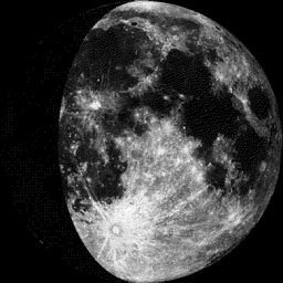
Moon Phase for November 20th at Midnight
2.0 Day Since First Quarter
______________________________________
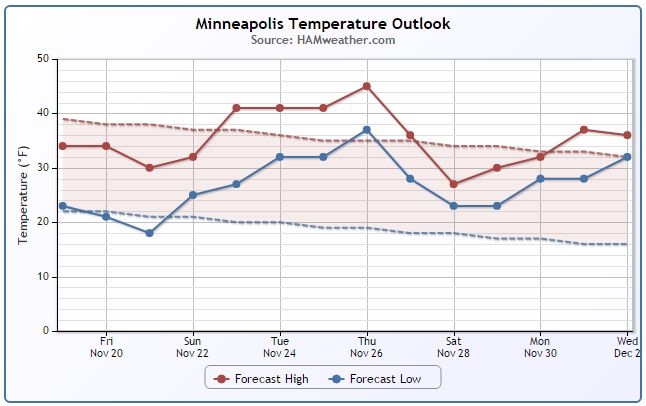
Minneapolis Temperature Trend
Below average temperatures will be with us through the weekend, but a nice little warm up with take place as we near Thanksgiving Day Thursday. This warmth will be in association with a storm system that could possibly bring more November rain to the area on Turkey Day itself! It appears that temperatures will quickly tumble as the storm moves east.
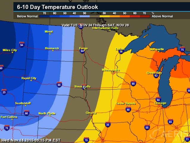
6 to 10 Day Temperature Outlook
According to NOAA's CPC, the 6 to 10 day temperature outlook suggests warmer than average conditions through the Great Lakes Region leading up to Thanksgiving Day, but cooler temperatures will quickly funnel in a couple of days later.
_____________________________
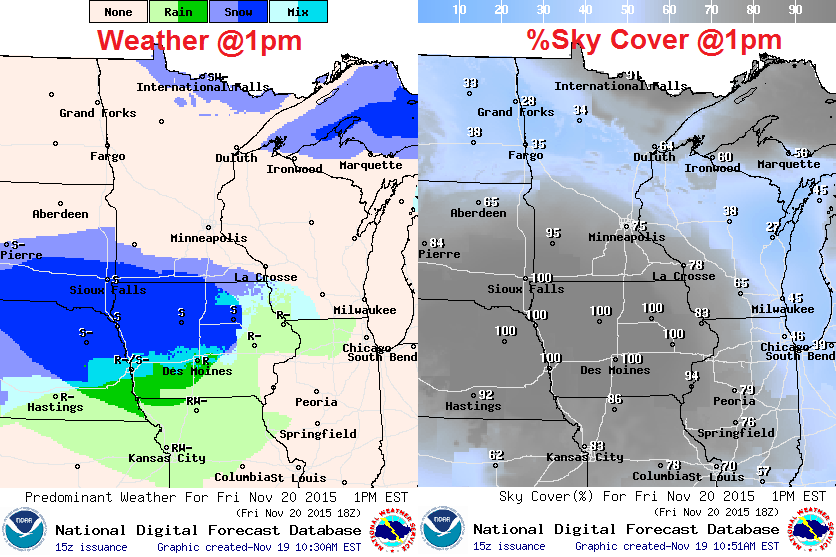
Friday Weather Outlook
Friday will be another chilly day across the region with feels like temperatures in the 10s and 20s across much of the state. Actual air temperatures will be running a little below average with reading in the 20s and 30s across the state.
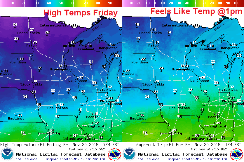
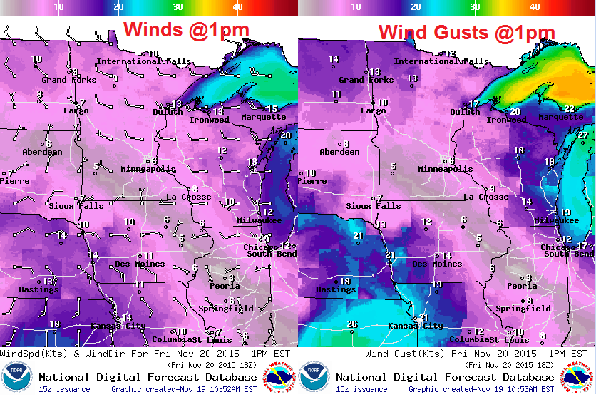
Friday Weather Outlook
The good news is that winds won't be nearly as strong as they were on Thursday.
Friday Weather Outlook
Light snow will fade across the northern part of the state through the day, but another system will scoot along the the MN/IA border with heavy snow potential just south of I-90 into Iowa
_________________________________________
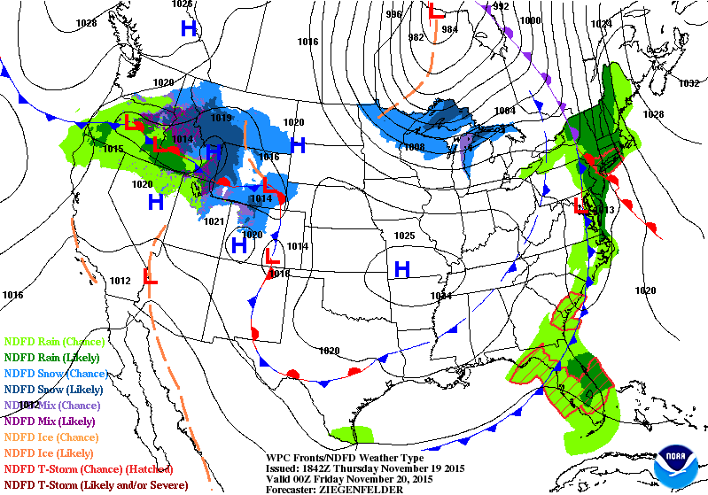
National Weather Outlook
The next impulse of energy is pretty evident on the weather loop below. Note the quick moving system as it slides in from the Pacific Northwest on Thursday to the Great Lakes by Saturday. Along it's path, there will be some shovelable/plowable snow amounts. In the wake of the system, MUCH colder air will push through the Central and Eastern part of the country.
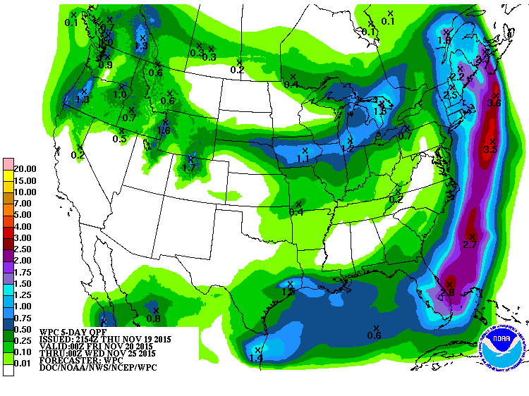
5 Day Precipitation Outlook
According to NOAA's WPC, the 5 day precipitation outlook suggests much lighter amounts than what we had earlier this week. Note the heaviest looks to be just east of the Eastern Seaboard. This is part of the same system that brought all the heavy rain, flooding and severe storms across the eastern half of the country earlier this week.
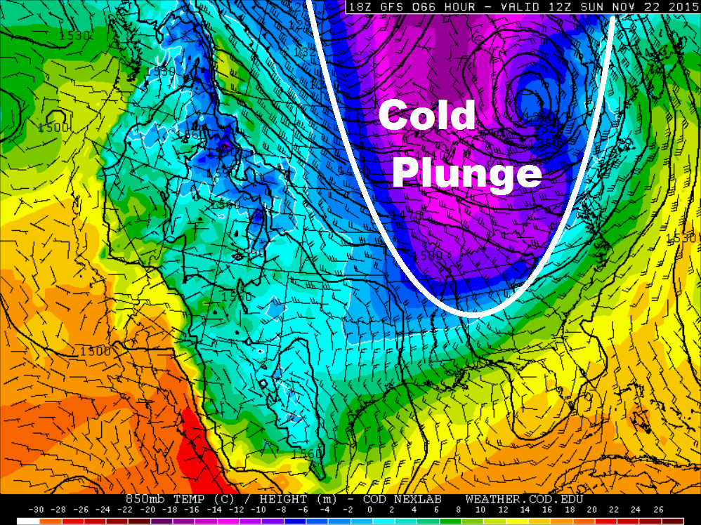
 Cold
Cold Weekend Ahead
The 850mb temperature outlook for AM Sunday suggests a big blob of cold air sinking into the southern part of the country. This will likely bring temperatures to below average levels across much of the Eastern U.S..
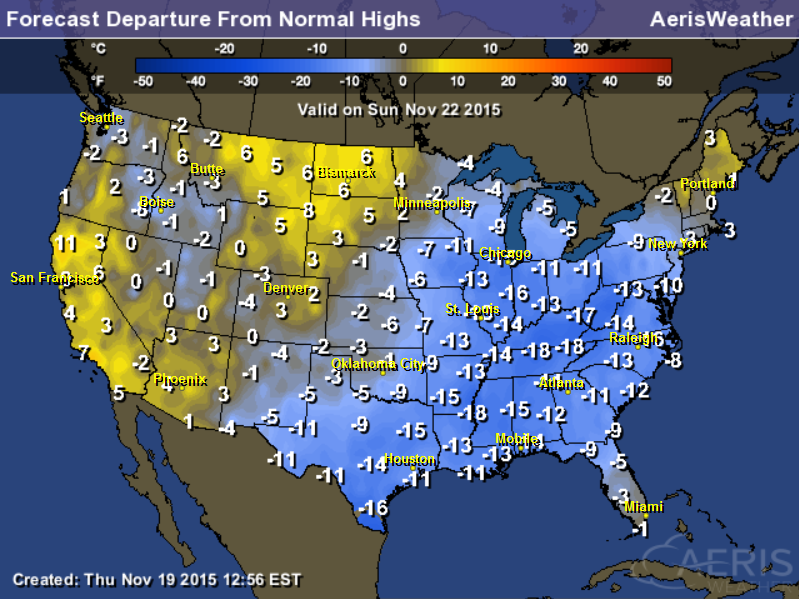
Highs From Average Sunday
Take a look at how much colder than average it will be on Sunday in the Eastern U.S.! Some spots will be nearly 10F to 20F below average!
Thanksgiving Day Temperature Outlook
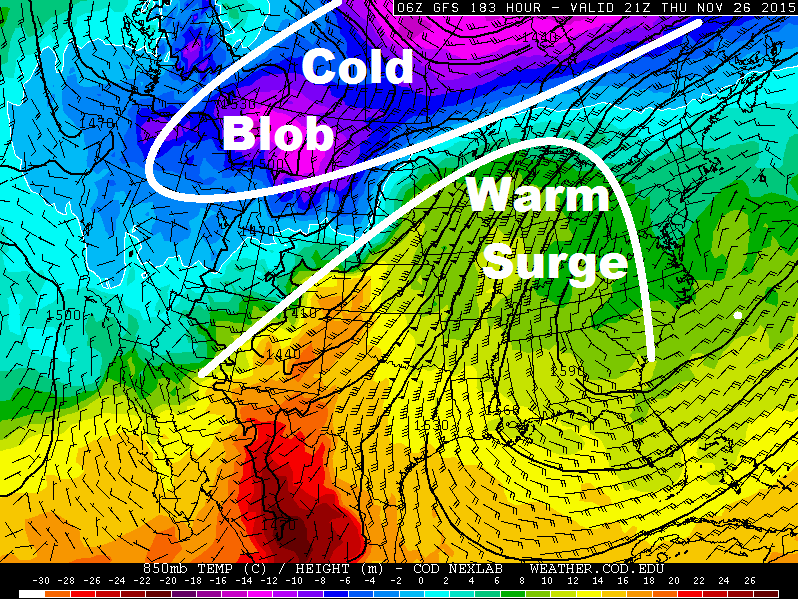
Here's a look at the temperatures outlook on Thanksgiving Day (Thursday, November 26th). Note how there seems to be cold air lurking across Canada and in the Pacific Northwest, but it appears that a warm surge will take up residence parts of the Central U.S.. Keep in mind that this may be ahead of a storm system that may bring rain and snow parts of the Midwest.
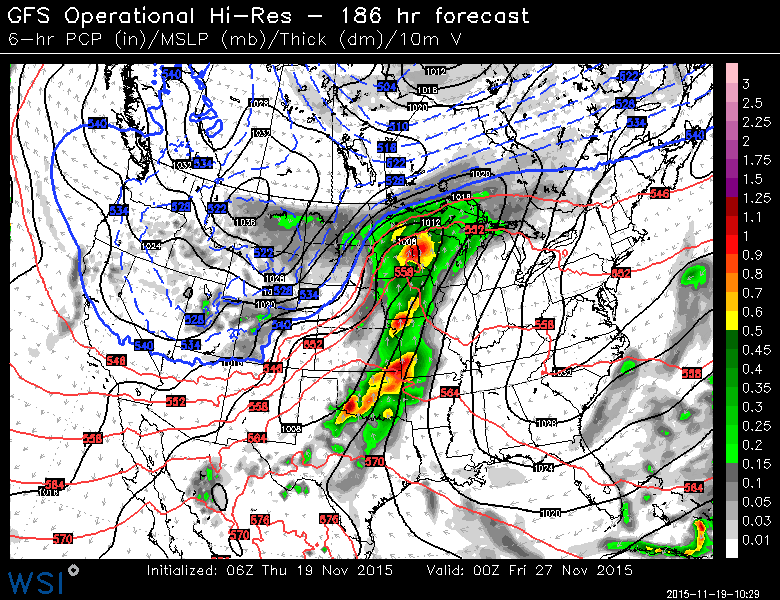
Thanksgiving Day Weather Outlook
Here's the weather outlook for next Thursday, which shows rain potential across the Central U.S. and possibly snow across the High Plains... stay tuned for more!
 ___________________________________
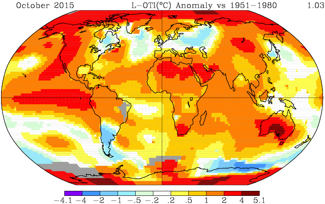
Record-crushing October keeps Earth on track for hottest year in 2015
"It was Earth’s warmest October ever recorded and it wasn’t even close. The record-shattering month was right in step with most of the preceding months in 2015 — which is positioned to easily rank as the warmest year on record."
"New data from the Japan Meteorological Agency and NASA show that the planet obliterated October records established just last year. October 2015 out-baked October 2014 by 0.34 degrees (0.19 Celsius) and 0.32 degrees (0.18 Celsius) in JMA and NASA’s analyses, respectively."
Read more from the WashingtonPost.com HERE:
Thanks for checking in and have a great rest of your week/weekend ahead! Don't forget to follow me on Twitter @TNelson

No comments:
Post a Comment