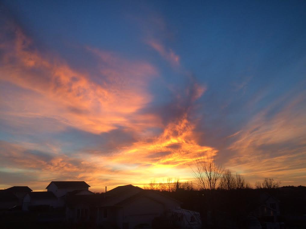
Memories of mid-October today, turning cooler this week
By Todd Nelson, filing in for Douglas
One year ago today, the Twin Cities woke up to 3 inches of snow on the ground, St. Cloud woke up to 7 inches. At this time last year, some of us had already had our first attempt at plowing and shoveling for the season.
We're off to a bit of a slow start this year. Despite being nearly 3.5 inches below average snowfall so far this season in the Twin Cities, we may be able to cut into that deficit a little heading into the second half of November as the weather pattern looks to remain active and temperatures begin to cool. Keep in mind that we typically average a little more than 9 inches of snow in the Twin Cities during the month of November! However, I am certainly not complaining about the lack of snow on the ground right now!
Enjoy memories of mid-October Sunday as temperatures warm into the mid/upper 50s, nearly 15-20 degrees above average! A steadier rain moves in early/mid week with a few rumbles of thunder possible Tuesday. We may chill down enough for a few wet flakes late week, but no worries, we'll stay shovel free.
______________________________
SATURDAY NIGHT: Mostly clear, not as chilly. Winds: SSW 5. Low: 39
SUNDAY: Mild mid-November sun. Winds: SSE 10-15. High: 58
SUNDAY NIGHT: Becoming cloudy, chance of light rain/drizzle overnight. Winds: SSE 10. Low: 45.
MONDAY: Cloudy, damp and breezy. Winds: SE 10-15. High: 53
TUESDAY: Periods of rain, rumbles of thunder?. Winds: ESE 10-20. Wake-up: 48. High: 58
WEDNESDAY: Breezy with a few lingering spits of rain. Winds: WSW 10-15. Wake-up: 46. High: 51
THURSDAY: Cooler with a stray shower? Winds: WNW 10-15. Wake-up: 35. High: 43
FRIDAY: Cold breeze. A few wet flakes. Winds: NNW 5-15. Wake-up: 29. High: 39.SATURDAY: Extra layers needed. Winds: WNW 5. Wake-up: 27. High: 36.
____________________________________________
This Day in Weather History
November 15th
1976: So far this year there were over three thousand forest fires in Minnesota
____________________________________________
Average High/Low for Minneapolis
November 15th
Average High: 41F (Record: 69F set in 1953)
Average Low: 27F (Record: 1F set in 1940)
_____________________________________________
Sunrise/Sunset Times for Minneapolis
November 15th
Sunrise: 7:10am
Sunset 4:44pm
Daylight lost since yesterday: ~2 minutue & 22 seconds
Daylight lost since summer solstice (June 21st): ~6 hours & 2 minutes
______________________________________________
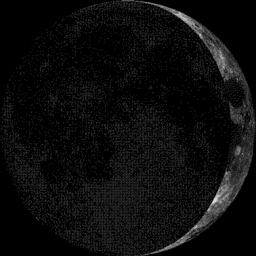
Moon Phase for November 15th at Midnight
3.0 Days Before First Quarter
______________________________________________
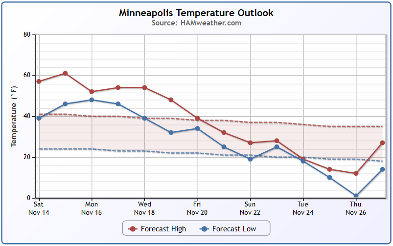
Minneapolis Temperature Trend
Above average temperatures look to continue through the next few days, but extended model runs are suggesting a bigger cool down by Thanksgiving week. We may all be shivering by the end of the month, but will we be shoveling?
_________________________________
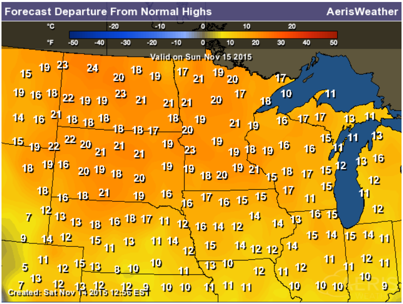
Highs From Average Sunday
Sunday will be another mild day across the region with temperatures running nearly 10-20 degrees above average!
____________________________________________
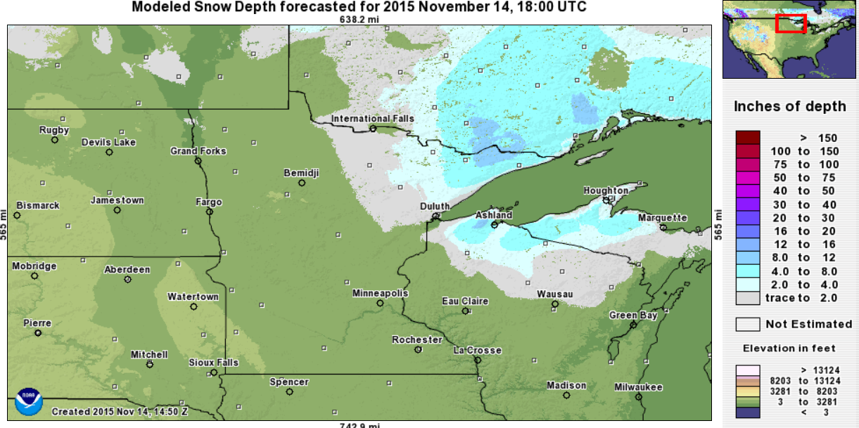
Snow Depth: November 14th, 2015
According to NOAA's NOHRSC, parts of northeastern MN, northern Wisconsin and the U.P. of Michigan are still covered in snow. Interestingly, some spots still have nearly 6" of snow coverage!
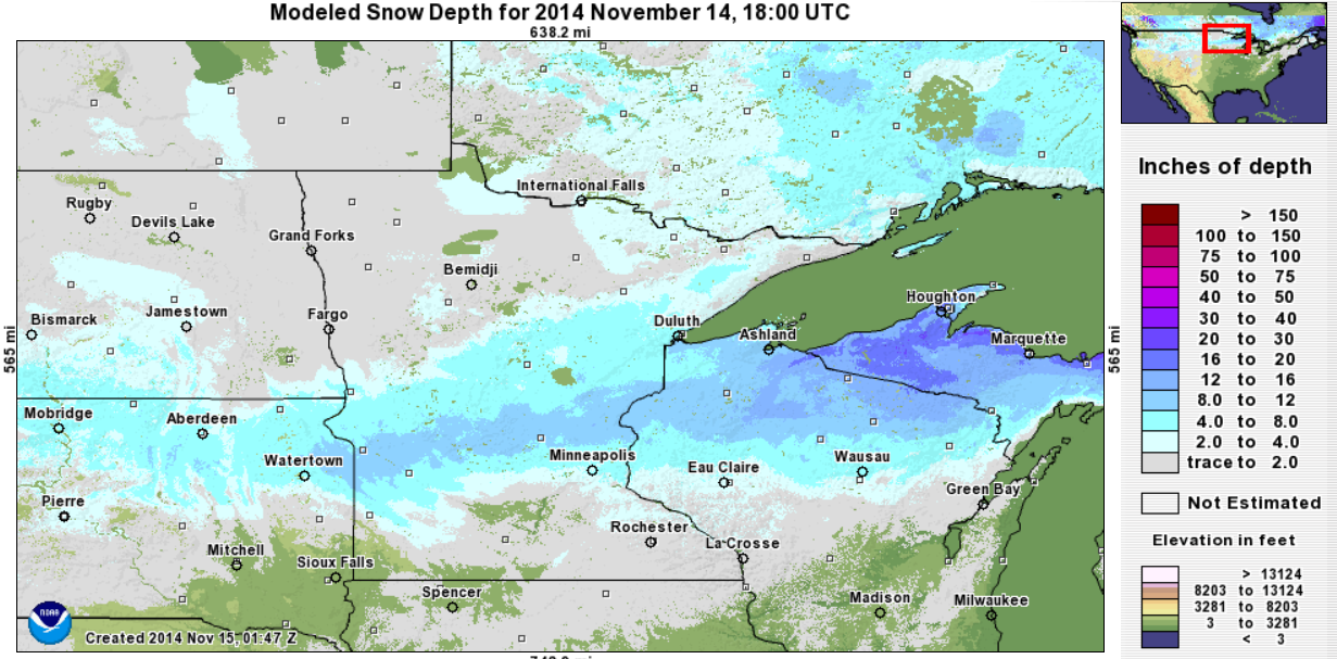
Snow Depth: November 14th, 2014
Interestingly, at this time last year, parts of Minnesota and Wisconsin had nearly 8" to 12" of snow on the ground!
________________________________________
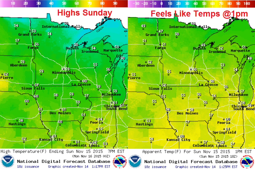
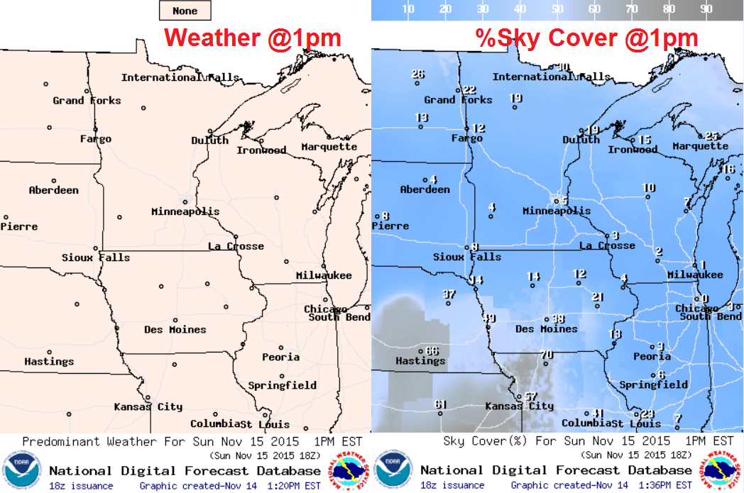
Sunday Weather Outlook
High temperatures on Sunday will warm into the mid/upper 50s across much of the state with a few low 60s not out of the question across far western/southern Minnesota. Feels like temperatures will be a little cooler thanks a southerly breeze. Regardless, 50s in November is very mild, so enjoy before the bottom drops out.
Sunday Weather Outlook
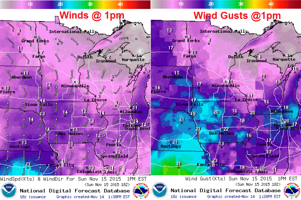
The images below suggest the projected wind at 1pm. It appears that winds will be stronger during the second part of the day across southern MN and across the Plains in advance of a developing storm system that will bring us rain chances through next week.
Sunday Weather Outlook
Mild temperatures and sunshine in mid-November? What else could you ask for? It doesn't look like we'll have any issues on Sunday if you have outdoor plans. Enjoy!
____________________________________
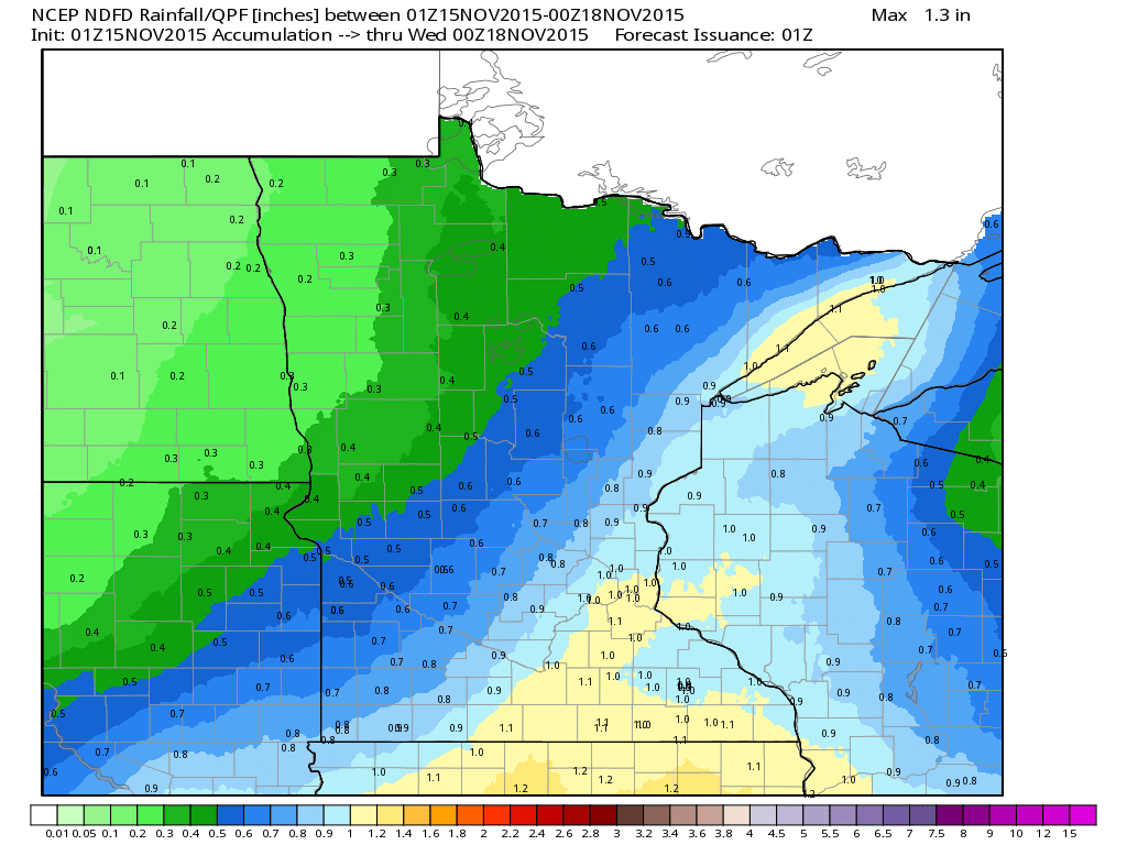
Rainfall Potential Through 6pm Monday
A developing storm system will start pushing moisture back into the state early next week with rainfall amounts nearly a couple of tenths of an inch by 6pm Tuesday... stay tuned for more!
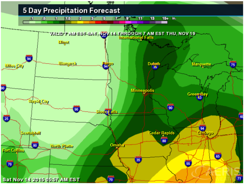
5 Day Precipitation Outlook
According to NOAA's WPC, the 5 day precipitation forecast suggests a fairly decent swath of moisture moving through the Upper Midwest through the middle part of next week. There is a possibility of precipitation amounts nearing 1" or more!
5 Day Snowfall Potential
Here's the thing, this next storm system moving through the middle part of the country this week will once again be laced with warmer temps and will keep snowfall amounts to a minimum across the Upper Midwest. The best chance of snowfall accumulations will be in the western half of the country, mainly in the higher elevations, but there will also be a band possible across parts of the Plains.
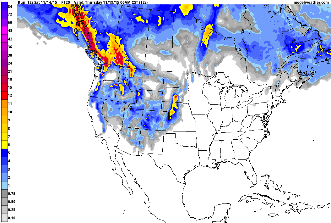
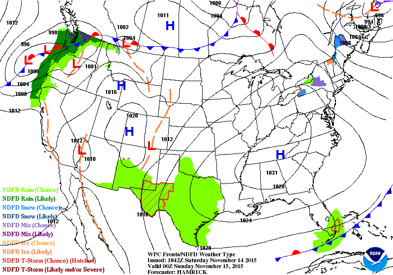
National Weather Outlook
Take a look at the developing storm system and note how much moisture will spread into the central part of the country by early next week. Heavy rain, flooding and high elevation snow in the Western U.S. will translate into heavy rain, some flooding and potentially strong storms in the Central U.S..
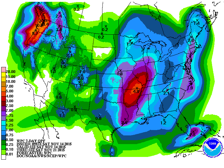
7 Day Precipitation Potential
According to NOAA's WPC, the 7 day precipitation potential suggests 2" to nearly 4"+ of rain across the Central U.S.. Meanwhile, heavy moisture looks to continue in the Pacific Northwest with as much as 5" to 10"+ possible, mainly in the higher elevations.
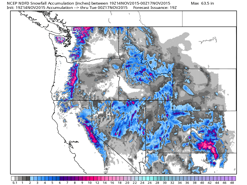
Western Snow Potential
Heavy snow potential will unfold across the high elevations in the Western U.S. as our next storm system moves through. The image below shows several locations nearing 12"+ through early next week. In fact, areas in the Olympic Mountains in northwestern Washington could see as much as 30"+ through the end of the weekend!
________________________________
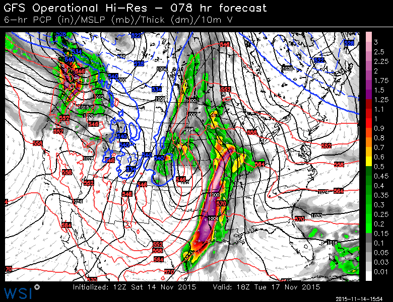
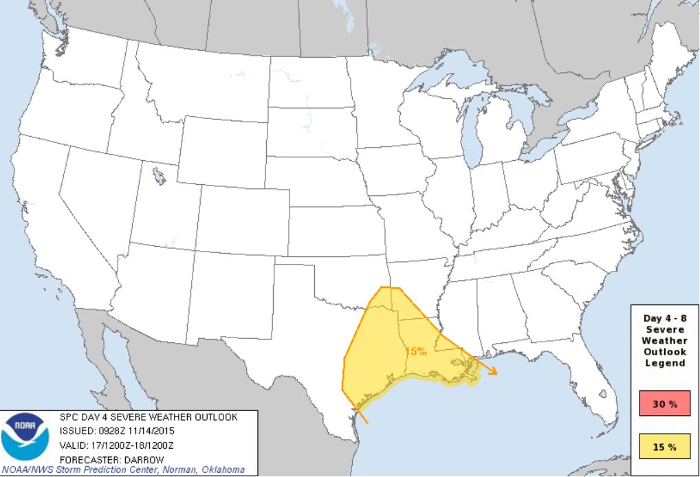
Severe Threat This Week?
As the fairly potent storm system moves out into the Plains, a line of strong to possibly severe storms will develop across the Southern Plains/Lower Mississippi Valley early this week. Here's the forecast for midday Tuesday, which shows the possibility of strong storms and heavy rain.
Severe Threat Monday
...SUMMARY...
   SEVERE THUNDERSTORMS ARE EXPECTED TO DEVELOP ACROSS THE CENTRAL AND
   SOUTHERN HIGH PLAINS MONDAY AFTERNOON.  TORNADOES ARE POSSIBLE WITH
   THIS ACTIVITY.  DAMAGING WIND AND HAIL THREAT WILL SPREAD EAST
   DURING THE OVERNIGHT HOURS.
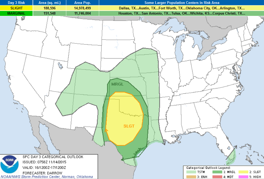
Severe Threat Tuesday
...DISCUSSION...
   SCATTERED SEVERE THUNDERSTORMS ARE POSSIBLE ACROSS PORTIONS OF
   EASTERN TX INTO THE LOWER MS VALLEY DURING THE DAY4 PERIOD.  WHILE
   PRIMARY SPEED MAX/SHORT-WAVE TROUGH ARE EXPECTED TO EJECT INTO THE
   UPPER GREAT LAKES...A SECONDARY SHORT WAVE MAY MAINTAIN TX SQUALL
   LINE OR INDUCE NEW DEVELOPMENT AS THIS FEATURE SHIFTS EAST.  AMPLE
   BOUNDARY-LAYER MOISTURE AND SUFFICIENT INSTABILITY WILL BE IN PLACE
   FOR ORGANIZED SQUALL LINE ALONG SRN PORTIONS OF COLD FRONT.
____________________________________________
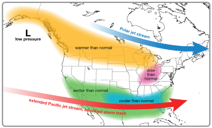
El Nino Impacts and Outlook
Ever wonder what the current El Nino impacts may be this year?
Here' a nice write up by the National Weather Service:
"The image below shows the typical pattern in the winter during El Niño events. The polar jet stream tends to stay to the north of the Great Lakes region, while the Pacific jet stream remains across the southern U.S. With the Great Lakes positioned between the storm tracks, warmer and possibly drier conditions can develop during El Niño events"
Thanks for checking in and have a great rest of your weekend and week ahead! Don't forget to follow me on Twitter @TNelsonWX

No comments:
Post a Comment