27 F. high yesterday in the Twin Cities.
34 F. average high on November 27.
10 F. high on November 27, 2014.
1" snow on the ground at MSP as of Saturday morning.
November 28, 1983:
Widespread snowfall occurs across much of central Minnesota with
snowfall totals at or above 1 foot in many areas. A record 15 inches
fell in Gaylord and 14 inches fell in Farmington.
November 28, 1960:
A major storm produces near hurricane force winds on Lake Superior,
with 20 to 40 foot waves on the lake. Erosion and damage occurred on the
North Shore.
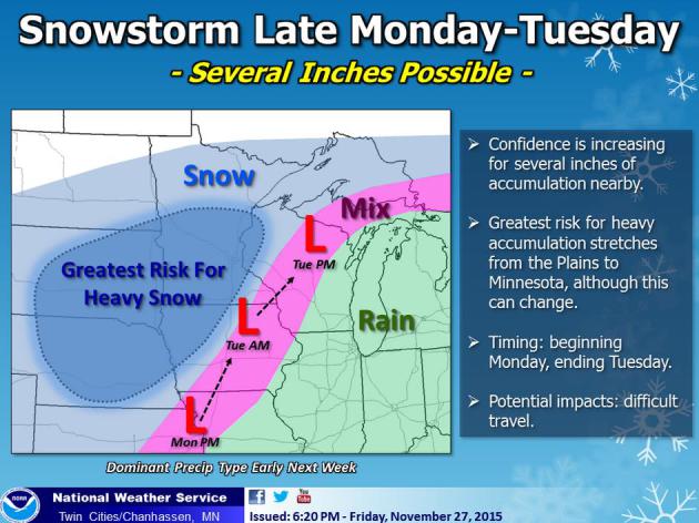
In Search of "Average"Accumulating - Potentially Plowable - Snow
by Tuesday?
A
year ago 9.4 inches of snow fell on MSP during the month of November.
We had already seen our first subzero low; Minnesota's lakes were icing
up. Snow lovers were encouraged. This year some lawns are still
pale-green, there's open water on most lakes and
Thursday's 1.3 inch snowfall qualified as a "storm". Average November snowfall in the Twin Cities is 9.3 inches. Not this year.
Cool sun spills over into
Sunday as weather cooperates with holiday shopping - getting home shouldn't be an issue. Old Man Winter will be well-behaved until
Monday night and
Tuesday, when a spoke of southern
moisture
rotates north, the lowest mile of the atmosphere marginally cold enough
for a few inches of snow. It's too early to predict specific amounts
but
Tuesday's commute may be problematic.
There
just isn't any frigid air across North America, and long-range models
show a mild bias into mid-December as steering winds blow from the
Pacific. Could the pattern shift in January? Possible, but El
Nino is forecast to linger into at least spring of 2016.
The maps remind me of 2011-2012, when 22.3 inches fell at MSP.
*
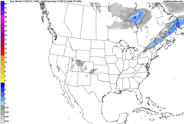
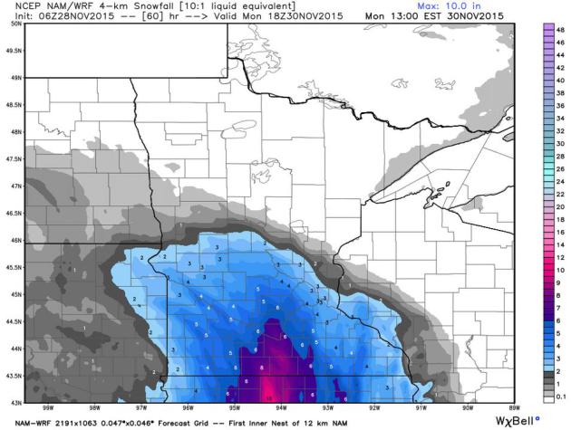
GFS guidance above (showing a potential for "plowable" amounts of snow
late Monday into Tuesday, especially southeastern Minnesota and western
Wisconsin, courtesy of NOAA and AerisWeather.
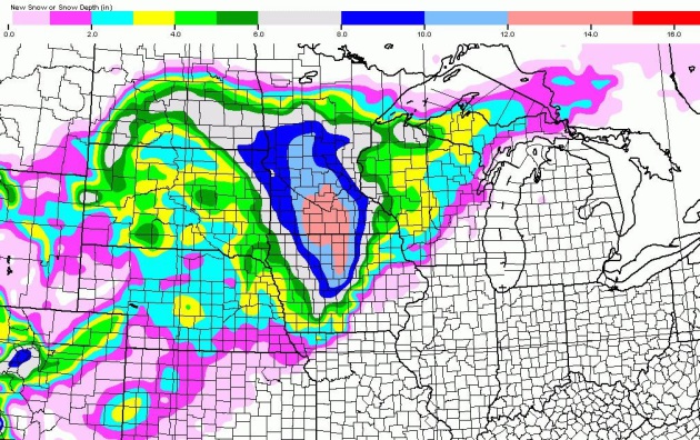
Holy Snowday!
For the record: I'm not buying this (NAM) solution, not yet. The 06z
run brings 8" into the metro with a foot for Mankato and Albert Lea. I
think this may be too aggressive, but if the storm moves slower, and
ample supplies of southern moisture surge north, we could certainly see
plowable amounts of snow Monday into Tuesday. Think of this as a worst
(best?) case scenario right now.
WRF Solution.
The higher-resolution WRF only goes out to 1 PM Monday, but it shows
some 2-4" accumulation in the metro by then, with as much as 8" over
south central Minnesota. The ECMWF (European) model suggests the best
chance of snow will come Monday night into Tuesday morning. Source:
WeatherBell.
Favorable Storm Track for Significant Snow.
Our biggest snowfalls come from storms tracking a couple hundred miles
southeast of MSP, ensuring a supply of not only southern moisture but a
deep layer of <32f a="" air="" all-snow="" and="" but="" changeover="" cities="" commute="" crippling="" enough="" event="" favorable="" for="" inch-amounts="" is="" it="" like="" lobbing="" looking="" make="" mess.="" mix="" more="" morning="" national="" not="" or="" p="" plowable="" premature="" probably="" rain.="" real="" s="" service.="" snow="" source:="" still="" this="" to="" tuesday="" twin="" weather="">
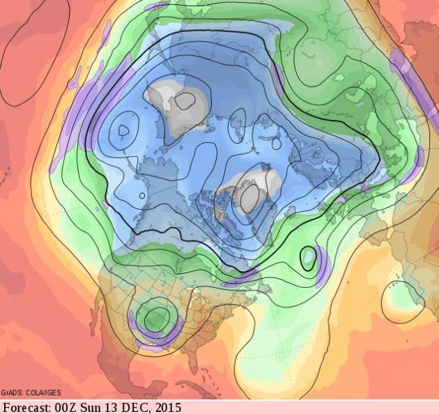
Mild Bias into mid-December, With a Side of Slush?
The GFS 500 mb upper level wind forecast valid Saturday evening,
December 12, shows a deep cut-off low over the south central USA, with
relatively mild air across most of the USA. Frankly this looks more like
mid-October than mid-December. The southerly branch of the jet is
becoming more active and Minnesota and Wisconsin may be brushed by some
of this (El Nino-enhanced) moisture.
One of the 3 Warmest Novembers in Recorded Minnesota History? That's according to climate guru Mark Seeley; here's an excerpt from this week's edition of
Minnesota WeatherTalk: "
Through
the first 25 days of November temperatures have been averaging well
above normal. It is likely that this month will conclude in a manner
that will rank it among the top three warmest Novembers in Minnesota
history, likely falling short of the warmest ever which occurred in
2001. Over 40 communities reported at least one day this month with an
afternoon temperature of 70°F or higher. In all 33 new daily maximum
temperature records were set within the National Weather Service
Cooperative Observer Network in Minnesota, and 145 daily warm minimum
temperature records were set, a remarkably large number. No low
temperature records were set anywhere in the state this month..."
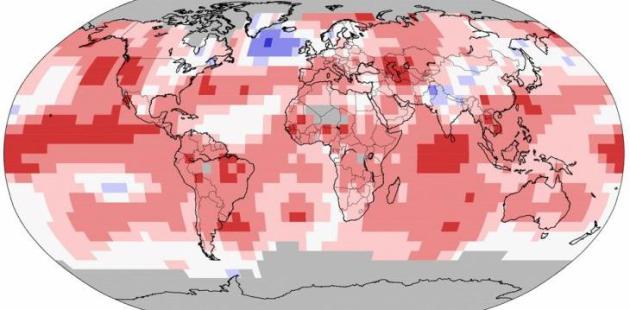
World Meteorological Organization: 2015 Like to be Warmest on Record; 2011-2015 Warmest Five-Year Period. Here's an excerpt from a
WMO press release: "
The
global average surface temperature in 2015 is likely to be the warmest
on record and to reach the symbolic and significant milestone of 1°
Celsius above the pre-industrial era. This is due to a combination of a
strong El Niño and human-induced global warming, according to the World
Meteorological Organization (WMO). The years 2011-2015 have been the
warmest five-year period on record, with many extreme weather events -
especially heatwaves - influenced by climate change, according to a WMO five-year analysis..."
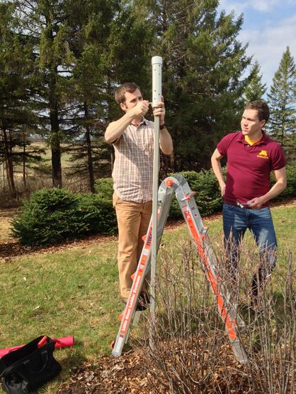
New Urban Heat Island Study Shows Surprising Variation in Air Temperatures Across Twin Cities.
Which brings up a quandary: how do meteorologists factor in urban
heating into their forecasts? Here's an excerpt of a recent press
release from
The University of Minnesota: "
Some
parts of the Twin Cities can spike temperatures up to 9°F higher than
surrounding communities thanks to the “urban heat island” effect,
according to a new study from the University of Minnesota. The study, which was funded by the Institute on the Environment and published in the Journal of Applied Meteorology and Climatology,
used a network of 180 sensors deployed throughout the Twin Cities
metropolitan area in residential backyards and city parks to paint the
most detailed picture anywhere in the world of how temperature varies
with time and place across pavement-filled metropolitan areas and
surrounding communities..."
Image credit above: "Brian Smoliak and research fellow Phil Mykleby install a temperature sensor at the Minnesota Landscape Arboretum."
Photo Credit: Angeline Pendergrass
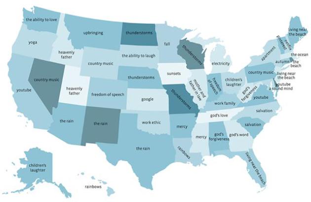
This Map Shows What People Are Most Thankful For in Each State. Minnesotans are most thankful for "fall"; Wisconsin residents most thankful for "thunderstorms". Really?
Mother Jones drills down: "
Earlier this week, Facebook's data team crunched the numbers on what users say they are most "thankful" for. The top two overall results were predictably "friends" and "family," which is heartwarming but sort of a snooze..."
TODAY: Sunny, seasonably cool. Winds: SW 5-10. High: 33
SATURDAY NIGHT: Mostly clear and chilly. Low: 18
SUNDAY: Partly sunny, no travel headaches getting home. Winds: E 3-8. High: 39
MONDAY: Clouds increase, snow at night. Wake-up: 23. High: 36
TUESDAY: Few inches of snow possible. Slippery roads. Wake-up: 30. High: 34
WEDNESDAY: Slushy start, skies begin to clear. Wake-up: 26. High: 38
THURSDAY: Plenty of sun, trending milder. Wake-up: 22. High: near 40
FRIDAY: Partly sunny, melting snow. Wake-up: 25. High: 42
Climate Stories...
Bill Gates Expected to Create Billion-Dollar Fund for Clean Energy. The New York Times has more details; here's an excerpt: "...
Bill Gates
will announce the creation of a multibillion-dollar clean energy fund
on Monday at the opening of a Paris summit meeting intended to forge a
global accord to cut planet-warming emissions, according to people with
knowledge of the plans. The fund, which one of the people described as
the largest such effort in history, is meant to pay for research and
development of new clean-energy technologies. It will include
contributions from other billionaires and philanthropies, as well as a
commitment by the United States and other participating nations to
double their budget for clean energy research and development, according
to the people with knowledge of the plans, who asked not to be
identified because they were not authorized to discuss the fund..."
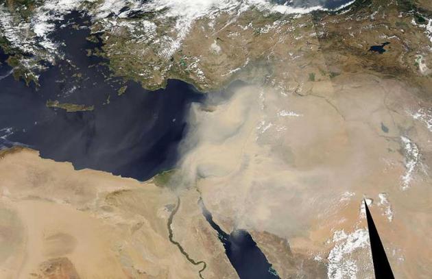
A "Climate of Insecurity": Global Warming as a "Threat Multiplier". Is
a warming (drying) climate in the Middle East and northern Africa
increasing the potential for destabilization? Here's an excerpt of an
article at
Worldcrunch: "...
Drawing a link between security
and climate change inspired mockery from some quarters. But this link
is a certainty, and a sufficiently unpleasant one that we systematically
forget it, only to see it raise its ugly head over and over again. In
March 2008, the High Representative of the European Union for Foreign
Affairs and Security Policy forwarded an unambiguous report to member
states on this very issue. Seven years after it was written, it clearly
served as an eerily accurate warning. The text said that global warming
acts as a "threat multiplier" in areas already suffering from social,
political, religious or ethnic tensions. "In the future, climate change
is likely to affect the social and political stability in the Middle
East and North Africa," the report read, pointing to "tensions related
to the management of water resources in the Jordan Valley and the
Euphrates and Tigris rivers, which are becoming scarce" and the
worsening tensions caused by rising temperatures..." (File image credit: NASA).
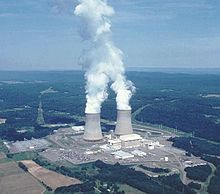
The New Atomic Age We Need.
The world is moving toward a low-carbon future, but not fast enough -
and cleaner, smaller, ultimately safer forms of nuclear energy may be
the only forms of non-carbon energy that scale fast enough, worldwide.
Peter Thiel makes a fairly compelling case at
The New York Times; here's a clip: "...
The single most important action we can take is thawing a nuclear energy
policy that keeps our technology frozen in time. If we are serious
about replacing fossil fuels, we are going to need nuclear power, so the
choice is stark: We can keep on merely talking about a carbon-free
world, or we can go ahead and create one. We already know that today’s
energy sources cannot sustain a future we want to live in. This is most
obvious in poor countries, where billions dream of living like
Americans. The easiest way to satisfy this demand for a better life has
been to burn more coal: In the past decade alone, China added
more coal-burning capacity than America has ever had. But even though
average Indians and Chinese use less than 30 percent as much electricity
as Americans, the air they breathe is far worse. They deserve a third
option besides dire poverty or dirty skies..."
Will We Write Earth's Next Chapter, or it's Obituary? Here's the intro to a story from National Geographic's Editor in Chief at
CNN: "
When
National Geographic first sent some of the world's best photographers
and mapmakers on assignment more than 125 years ago, we didn't set to
capture the "before" photos for an imperiled planet. But that's exactly
what happened. Over the decades, from the Matterhorn to the Great
Barrier Reef to the West Antarctic Ice Sheet, these intrepid explorers
became the visual record-keepers of climate change...."
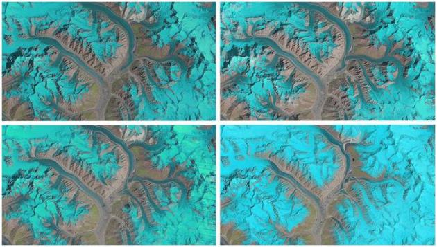
ESA Animations Show 25 Years of Glacier Movement in a Single Second.
Gizmag has the story - here's the intro: "
A
researcher at Switzerland's University of Zurich has combined 25 years
worth of satellite imagery to show the complex behavior of glaciers in a
single second. The effort made use of data collected by NASA's Landsat
satellites, focusing on the Karakoram mountain range in Asia. The
animations were created by glaciologist Dr. Frank Paul, and form part of
the ESA's Climate Change Initiative, which is combining datasets to
build the best possible picture of glacier movement. The GIFs were made
by combining between seven and 15 false-color images taken by three
different Landsat
satellites between the years 1990 and 2015. The glaciers can be seen in
light blues to cyan, with water in dark blue, vegetation in green, bare
ground in brown and clouds in white..."
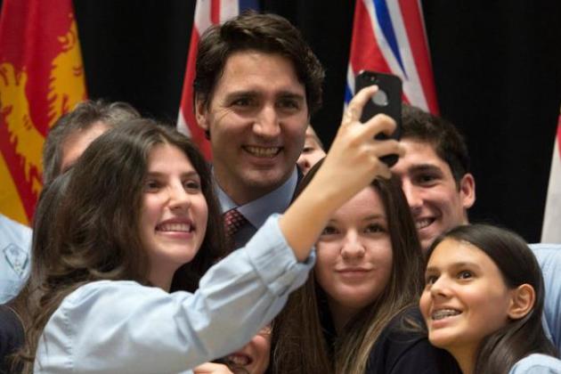
Canada's New Leadership Reverses Course on Climate Change.
The New York Times reports; here's a clip: "
In less than a month, Canada has executed a complete about-face on global climate change. With the defeat of the Conservatives in the October general election, out went nearly a decade of Canada making itself something of a global outcast on the issue. The record of the former prime minister, Stephen Harper, on climate change was marked by retreat, foot-dragging, and hand-wringing over the economic consequences of moving too quickly. The new prime minister, Justin Trudeau,
and his Liberals are now trying to make up for lost time. And along
with the left-leaning New Democrats, who wrested power from the
Conservatives in the oil-rich province of Alberta last spring, they have now moved climate-change policy to the top of the country’s political agenda..."
Image credit above: "Prime Minister Justin Trudeau with high school students in Ottawa after an information session on climate change." Credit Adrian Wyld/The Canadian Press, via Associated Press.


No comments:
Post a Comment