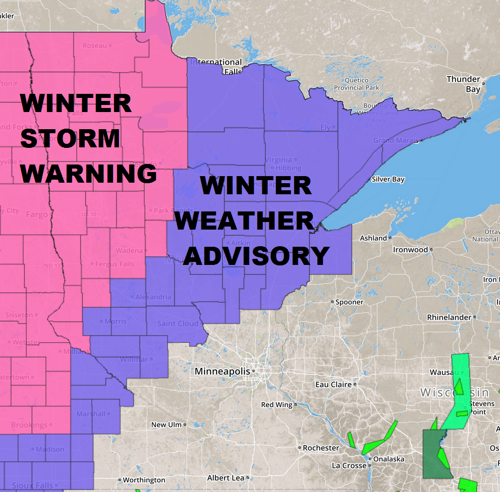
...WINTER STORM BRINGS SNOW LATE TONIGHT INTO WEDNESDAY...

.A WINTER STORM WILL BRING 3 TO 6 INCHES OF SNOWFALL ACROSS MUCH
OF NORTHEAST MINNESOTA LATE TONIGHT INTO TOMORROW...WITH THE
POSSIBILITY FOR RAIN MIXING WITH SNOW THROUGH THE AFTERNOON
WEDNESDAY. ALONG THE NORTH SHORE OF LAKE SUPERIOR EASTERLY WINDS
WILL RESULT IN LAKE EFFECT SNOW BEGINNING THIS EVENING AHEAD OF
THE MAIN LOW PRESSURE SYSTEM. A WINTRY MIX OF FLURRIES...FREEZING
DRIZZLE...AND SLEET MAY PRECEDE THE MAIN AREA OF MODERATE TO
HEAVY SNOWFALL WHICH ARRIVES FROM SOUTH TO NORTH LATE TONIGHT
INTO WEDNESDAY MORNING. THE HEAVIEST SNOW WILL BE ALONG THE
HIGHWAY 2 CORRIDOR INCLUDING THE TWIN PORTS DURING THE MORNING
COMMUTE WITH SNOWFALL RATES OVER ONE INCH PER HOUR POSSIBLE. IN
THE AFTERNOON THIS AREA OF INTENSE SNOWFALL MOVES NORTH INTO THE
MINNESOTA ARROWHEAD...BUT AS THE AFTERNOON GOES ON RAIN MAY MIX
WITH SNOW AS FAR NORTHWEST AS THE MINNESOTA IRON RANGE WITH ALL
RAIN OVER NORTHWEST WISCONSIN. THE MOST INTENSE SNOWFALL ENDS
WEDNESDAY EVENING...BUT LIGHT SNOWFALL MAY LINGER INTO THE NEXT
DAY OR TWO AS COLDER AIR MOVES IN FROM THE NORTH.
...WINTER STORM WARNING IN EFFECT FROM MIDNIGHT TONIGHT TO
MIDNIGHT CST WEDNESDAY NIGHT...

THE NATIONAL WEATHER SERVICE IN GRAND FORKS HAS ISSUED A WINTER
STORM WARNING FOR SNOW AND BLOWING SNOW...WHICH IS IN EFFECT FROM
MIDNIGHT TONIGHT TO MIDNIGHT CST WEDNESDAY NIGHT. THE WINTER STORM
WATCH IS NO LONGER IN EFFECT.

* TIMING...EXPECT SNOW TO DEVELOP AROUND MIDNIGHT AND THEN
  DIMINISH AROUND MIDNIGHT WEDNESDAY NIGHT.

* PRECIPITATION RATES...THE HEAVIEST SNOWFALL RATES WILL OCCUR
  BETWEEN MIDNIGHT AND 6 AM WEDNESDAY.

* SNOW ACCUMULATIONS...TOTAL SNOW ACCUMULATIONS OF 4 TO 7 INCHES
  ARE EXPECTED.

* WINDS / VISIBILITIES...LOOK FOR SIGNIFICANT REDUCTIONS IN
  VISIBILITY AT TIMES DURING FALLING AND BLOWING SNOW.

* IMPACTS...PLAN ON DIFFICULT DRIVING CONDITIONS...INCLUDING
  DURING THE MORNING COMMUTE ON WEDNESDAY.
...WINTER WEATHER ADVISORY IN EFFECT FROM 6 PM THIS EVENING TO
6 PM CST WEDNESDAY...

* LOCATIONS...WALKER...PINE RIVER AND BRAINERD.

* TIMING...EARLY MORNING WEDNESDAY THROUGH WEDNESDAY EVENING.

* SNOW ACCUMULATIONS...3 TO 6 INCHES.

* VISIBILITIES...A HALF MILE OR LESS AT TIMES.

* IMPACTS...INTENSE SNOWFALL LATE TONIGHT INTO EARLY WEDNESDAY
  MORNING WILL RESULT IN DETERIORATING TRAVEL CONDITIONS.
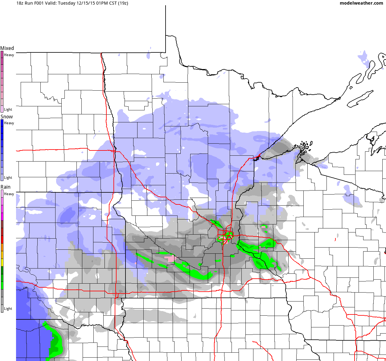
Simulated Radar
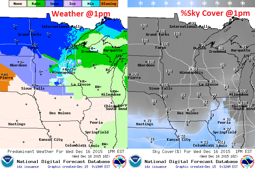
Waves of precipitation will move through the region through Wednesday night. Interestingly, warmer air will wrap into the center of the storm (warm enough for rain) near the Twin Cites, which will limit the amount of wintry precipitation and snow that will fall here. The best chance of shovelable/plowable snow will be found across the Dakotas and into northern Minnesota.
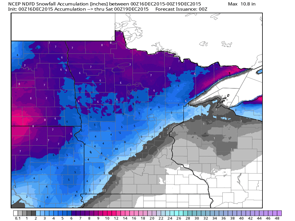
Snowfall Potential
The
heaviest snowfall still looks to be well north of the Twin Cities with
as much as 4" to 7" possible from parts of the Dakotas into northern
Minnesota. There may be a few inches of slush across parts of
central/western Minnesota, but the Twin Cities may be lucky to see a
slushy half inch. There appears to be more rain and mix than snow
potential for the Twin Cities as this storm blows through.
December Worms, Rain and Slush; Mild Trend Lingers
By Paul Douglas
I should have taken more psychology classes. Some days I feel like a therapist, whispering sweet nothings into the ears of frustrated Minnesota snow lovers.
John Judkins reports an outbreak of worms in Cottage Grove, in mid-December. Grant Offermann sent me this digital plea: "You gotta help me though, I'm a winter enthusiast and need some snow. My ski's are collecting dust....my Siberian husky is shedding like its spring time again. Give me something to look forward to!"
Uh, I'm just the messenger and the headline remains the same: think Kansas City winter this year. The pattern may shift abruptly next month or February, but the trends are the trends. The Godzilla of El Ninos will probably keep us milder and slushier than average, into March.
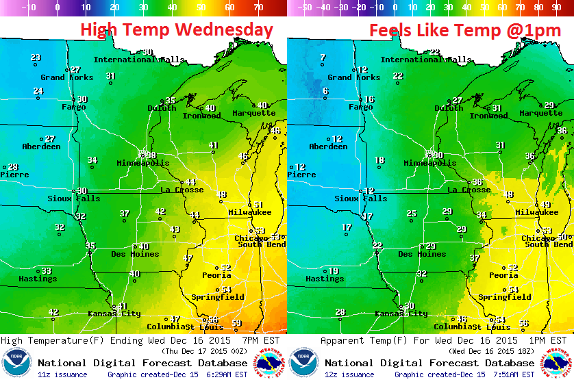
To get all-snow temperatures in the lowest mile of the atmosphere should be less than 32F. Once again today there's too much warm air aloft for snow in the metro. Expect mostly rain at MSP; a few inches of slush for central and western MN.
We chill down by late week - but expect 30s to near 40F much of next week. Santa will need his red SUV.
__________________________
Extended Forecast
TUESDAY NIGHT: Wintry mix likely. Little to now snow accumulation expected. Winds: E 10-15. Low: 34.
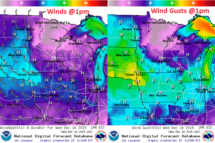
WEDNESDAY: Rain mixes with snow. Wet roads. Little to now snow accumulation expected. Winds: SE turning WSW 10-15. High: 39
WEDNESDAY NIGHT: Lingering light snow. Turning breezy and cooler. Little to now snow accumulation expected. Winds: W 15-30. Low: 25.
THURSDAY: Few flakes, feels like December. Winds: NW 10-20. High: 28
FRIDAY: Peeks of sun, heavier coats required. Winds: NW 10-15. Wake-up: 16. High: 21
SATURDAY: Some sun, feeling better. Winds: S 10-15. Wake-up: 9. High: 29
SUNDAY: Patchy clouds, thawing out again. Winds: S 10-15. Wake-up: 26. High: 39
MONDAY: Drizzle, light mix possible. Winds: NE 10-15. Wake-up: 31. High: 36.
TUESDAY: More drizzle or light rain. Winds: S 10-15. Wake-up: 28. High: 37.
___________________________
This Day in Weather History
December 16th
2000: A surface low pressure system tracks east-northeast through Iowa on the 18th and then into western Illinois during the early evening hours. Extreme south central and southeast Minnesota received 6 to 10 inches of snow, including Albert Lea with 10.5 inches, Kiester and Bixby with 6.0 inches.
1972: Fairmont has its fifteenth consecutive day with lows at or below zero degrees Fahrenheit.
1940: A snowstorm hits much of Minnesota. Water equivalent of the snow was 1.27 inches at Winona.
___________________________
Average High/Low for Minneapolis
December 16th
Average High: 27F (Record: 58F set in 1939)
Average Low: 12F (Record: -22F setin 1876)
___________________________
Sunrise/Sunset Times for Minneapolis
December 16th
Sunrise: 7:44am
Sunset: 4:32pm
*Daylight lost since yesterday: ~28 seconds
*Daylight lost since the summer solstice (June 21st): ~6 hours and 49 minutes
____________________________
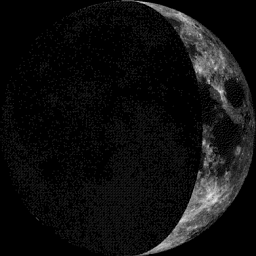
Moon Phase for December 16th at Midnight
1.3 Days Before First Quarter
______________________________
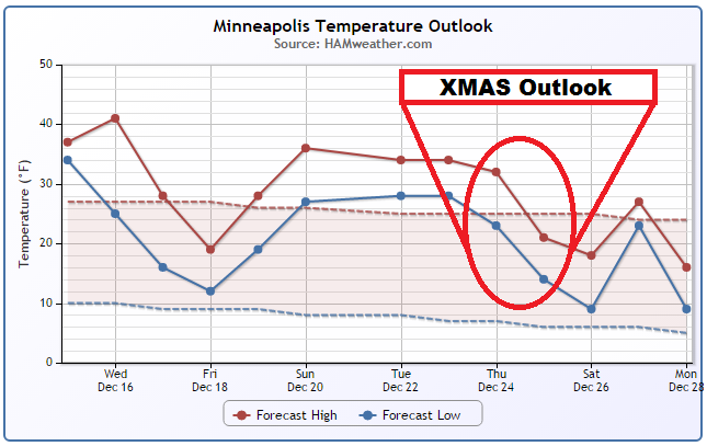
Minneapolis Temperature Trend
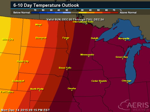
6 to 10 day Temperature Outlook
According to NOAA's CPC, the 6 to 10 day temperature outlook suggests above temperatures moving in just before the Christmas Holiday. This outlook also mimics the December 20th - December 24th above average temperature trend in the graphic above.
_________________________
Wednesday Weather Outlook
Wednesday Weather Outlook
Wednesday Weather Outlook
__________________________________
National Weather Outlook
The storm system moving through the Midwest through Midweek will slide into Canada through the end of the week as a line of showers and even a few storms slide east to the East Coast. In the wake of the storm, colder air will filter in, but only for a brief time. Meanwhile, heavier precipitation continues in the Pacific Northwest.
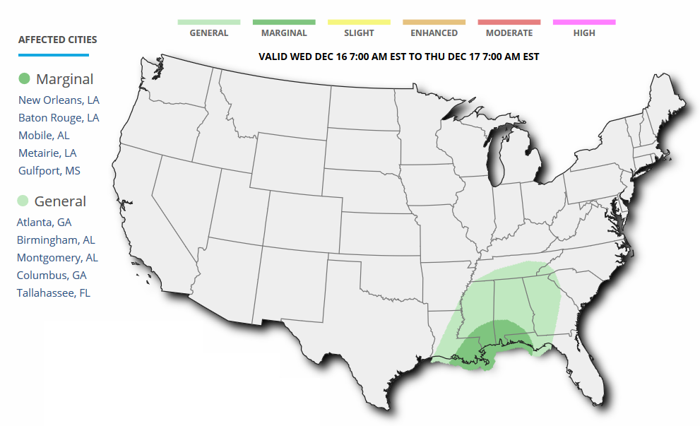
Severe Threat Wednesday
According to NOAA's SPC, there is a MARGINAL risk of severe weather across parts of the Gulf Coast on Wednesday.
...SUMMARY...
   SCATTERED THUNDERSTORMS ARE EXPECTED ACROSS PORTIONS OF THE GULF
   COAST STATES WEDNESDAY...A FEW MAY BE STRONG WITH GUSTY WINDS.

   ...SYNOPSIS...
   MATURE CYCLONE CENTERED OVER THE MID MO VALLEY AT THE BEGINNING OF
   THE PERIOD WILL PROGRESS NEWD INTO WRN ONTARIO WHILE AN ATTENDANT
   COLD FRONT MOVES QUICKLY EWD ACROSS THE MS/OH/TN RIVER VALLEYS AND
   THE CNTRL GULF COAST STATES...REACHING THE APPALACHIANS BY THE END
   OF THE PERIOD. AN ADDITIONAL SHORTWAVE TROUGH IS EXPECTED TO MOVE
   THROUGH THE SRN PLAINS AND INTO THE LWR MS VALLEY...ENCOURAGING THE
   PERSISTENCE OF LONG WAVE TROUGHING ACROSS THE CONUS.
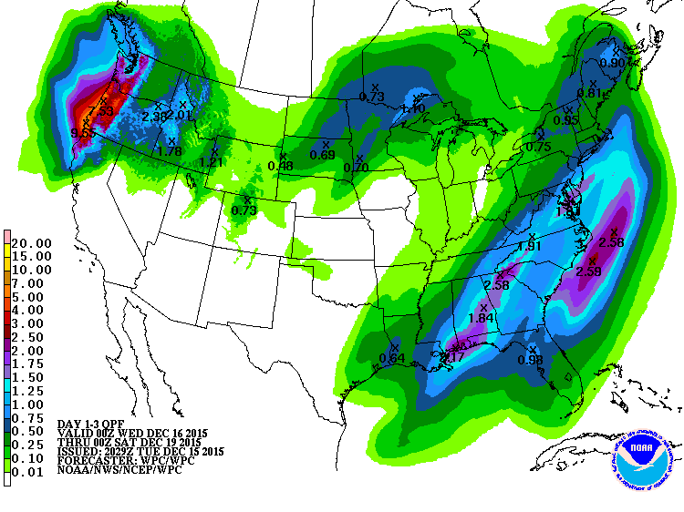
3 Day Precipitation Outlook
According to NOAA's WPC, the 3 day precipitation forecast suggests 3 main areas of precipitation through the end of the week. Showers and storms in the east/southeast will bring as much as 1" to nearly 3" of rain to some areas there, while snow and a wintry mix will be found across the Midwest. Heavy precipitation will continue in the Pacific Northwest with as much as 4" to 8"+ possible in spots.
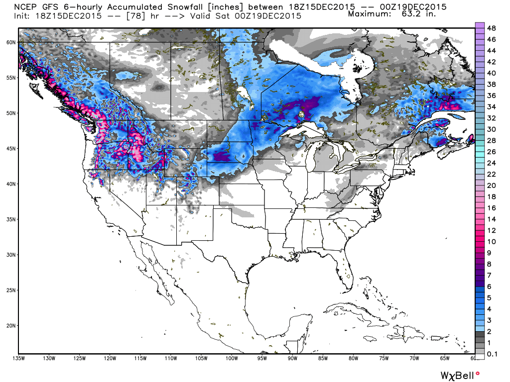
Snowfall Potential
Here's the snowfall potential through PM Friday. Note the fairly large swath across parts of the Midwest as our current storm system wraps up there through PM Wednesday, while some of the heaviest snow will be found across parts of the Cascades and the Northern Rockies as heavy Pacific moisture continues to blow in.
____________________________________
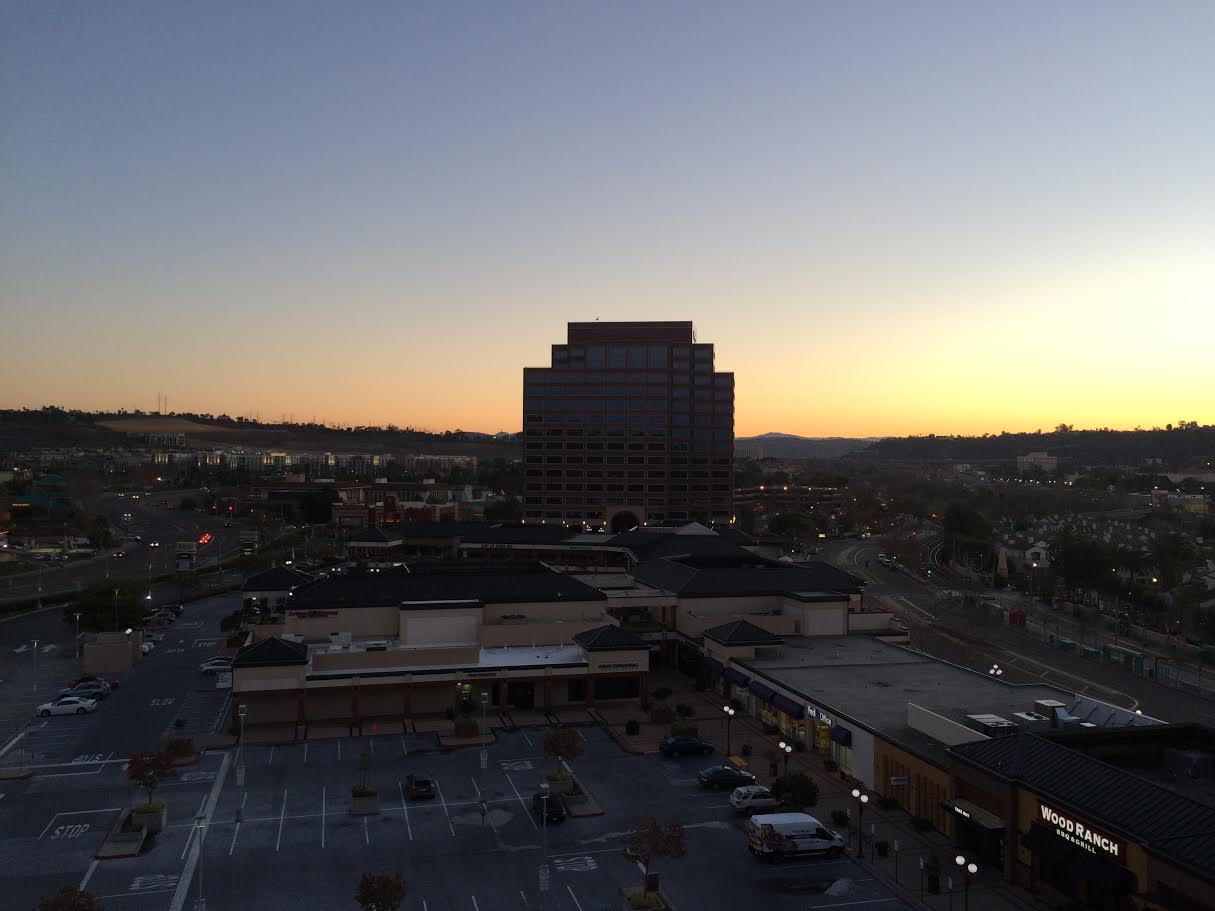
Chilly in the Southwest
Thanks to Aaron Weidner for the picture below who is in San Diego enjoying sunshine and temperatures in the 60s this week. However, temperatures are running a little cooler than average across much of the Southwest in the wake of a large trough of low pressure that brought heavy snow to parts of the Rockies and Central/Northern Plains.
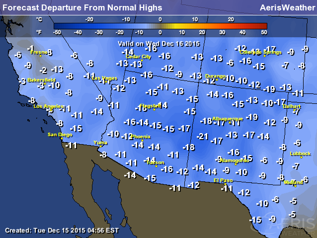
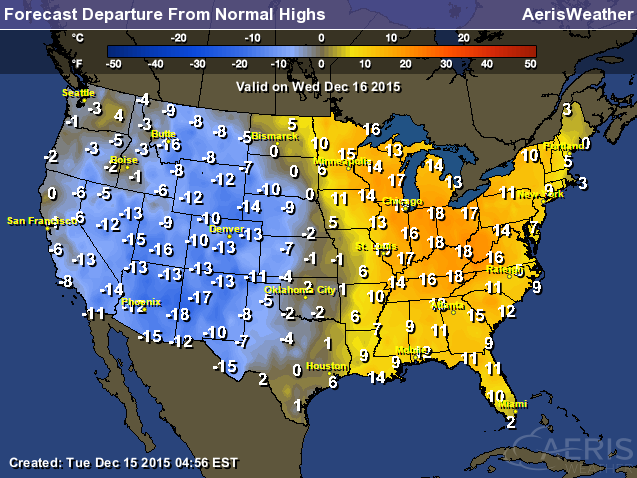
Highs From Average Wednesday
Several locations will be running nearly 10F to near 20F below average on Wednesday with overnight lows in the 20s and 30s.
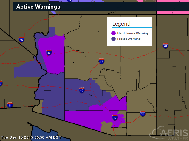
Frost/Freeze Concerns
The National Weather Service has issued a number of freeze warnings for parts of the Southwest for Wednesday and Thursday morning for temperatures that will likely dip into the 20s and 30s
...HARD FREEZE WARNING IN EFFECT FROM MIDNIGHT TONIGHT TO 8 AM MST WEDNESDAY MORNING... ...HARD FREEZE WATCH IN EFFECT FROM LATE WEDNESDAY NIGHT THROUGH THURSDAY MORNING...
THE NATIONAL WEATHER SERVICE IN TUCSON HAS ISSUED A HARD FREEZE WARNING...WHICH IS IN EFFECT FROM MIDNIGHT TONIGHT TO 8 AM MST WEDNESDAY.
A HARD FREEZE WATCH HAS ALSO BEEN ISSUED FROM LATE WEDNESDAY NIGHT THROUGH THURSDAY MORNING.
* IMPACTS...A PERIOD OF WELL BELOW FREEZING TEMPERATURES MAY KILL SENSITIVE VEGETATION. OUTDOOR WATER PIPES MAY NEED TO BE WRAPPED...DRAINED...OR ALLOWED TO DRIP SLOWLY TO PREVENT POSSIBLE BURSTING.
* TEMPERATURES...MINIMUM TEMPERATURES IN THE 20S WITH SEVERAL HOURS BELOW 28 DEGREES ARE FORECAST TO OCCUR ACROSS PORTIONS OF SOUTHEAST PINAL COUNTY...SOUTH CENTRAL PINAL COUNTY AND PIMA COUNTY INCLUDING THE TUCSON METRO AREA.
* TIMING...TEMPERATURES WILL FALL BELOW FREEZING AROUND MIDNIGHT IN MOST LOCATIONS THE NEXT COUPLE OF NIGHTS...WITH THE COLDEST TEMPERATURES EXPECTED TO OCCUR BETWEEN 5 AM AND 8 AM BOTH WEDNESDAY AND THURSDAY MORNINGS.
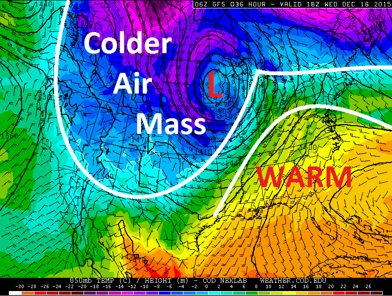
850mb Temperature Outlook
The
storm system currently in place over the Midwest is the culprit for the
bigger cool down across the Western U.S.. Meanwhile, temperatures ahead
of the storm are still running WELL above average across much of the
Eastern U.S.. In fact, more record warmth may be possible again Wednesday
in a few locations.
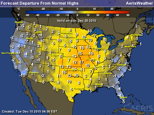
Highs From Average Wednesday
Highs From Average Sunday
Temperatures
will briefly cool behind our current storm system as it plows east
through the end of the week. However, warmer temperatures will quickly
move back in over the weekend/next week across the Central U.S., where
temperatures could once again warm to near 10F - 20F above average!
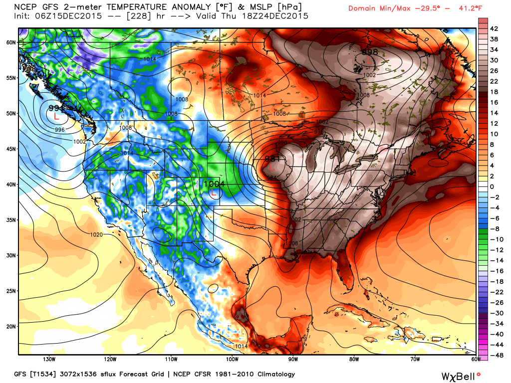
Christmas Eve Temperature Anomaly
Temperatures
look to stay quite warm in the eastern half of the country as we
approach Christmas eve with temperatures potentially running well above
average. Extended model runs are also suggesting a developing storm
system during that time period as well... stay tuned!
______________________________________
First building code improvements adopted based on Joplin tornado study
Here's an interesting story from ScienceDaily.com regarding improved building codes in association with the National Institute of Standards and Technology (NIST) study of the EF-5 Joplin, MO tornado from 2011.
Source: National Institute of Standards and Technology (NIST)
Summary: Protecting schools and their associated high-occupancy buildings from the most violent tornadoes is the goal of the first approved building code changes based on a technical investigation into the impacts of the deadly tornado that struck Joplin, Mo., on May 22, 2011.
Read more from ScienceDaily.com HERE:
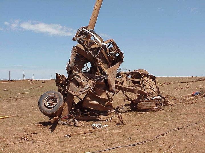
The power of an EF-5 tornado is evident in this photo of a truck wrapped around a utility pole in the aftermath of a May 1999 twister in Oklahoma in which wind speeds of more than 500 kilometers (300 miles) per hour were recorded. New code changes based on recommendations from NIST's Joplin, Mo., tornado study will help protect building occupants in areas where such storms are most likely to occur.
Credit: National Severe Storms Laboratory, NOAA
_____________________________
Thanks for checking in and have a great rest of your week! Don't forget to follow me on Twitter @TNelsonWX

No comments:
Post a Comment