40 F. high temperature yesterday in the Twin Cities.
27 F. average high on December 13 at KMSP.
51 F. high on December 13, 2014.
December 14, 1996:
Snowfall exceeding one foot is reported from south central Minnesota
through portions of the Twin Cities metropolitan area. Some of the
higher snow totals include 15 inches at Rockford, 14 inches at Cedar and
North Branch, 13 inches at Stewart and 7 to 10 inches across the
central and southern parts of the Twin Cities metropolitan area.
December 14, 1933: A severe ice storm hits southeast and central Minnesota.
Rainy, Icy, Slushy Mix TodayDecember Returns Late Week
So here we are, a week before the winter solstice, enjoying a mixed bag of rain, sleet and wet snow. We shouldn't be surprised.
Dr.
Mark Seeley has documented a 4X increase in midwinter rain and ice
since 2000. We're still seeing cold fronts and snowstorms, but the
volume and duration of bitter air, sustained hours below zero, has
steadily decreased since the 1970s. It's not getting as cold - or
staying as (consistently) bitter as it did for your parents and
grandparents.
It's hard finding anyone upset by the prospect of
less pain, but the result may be more slop-storms like today. Keeping
snow on the ground for an entire winter has become something of a
rarity.
Today we're right on the rain/snow line; a warm layer
aloft may re-freeze raindrops into sleet (ice pellets), even an inch of
mushy slush. Winds gust past 30 mph - it will be raw and unpleasant out
there.
A second storm
on Wednesday
may drop another inch of snow with more over central and western
Minnesota. A cosmetic coating of snow on the ground is possible here by
late-week with highs stuck in the 20s - a wind chill dipping to 5F. You
know, December.
We warm up to 40F by
Sunday; 30s lingering into Christmas Day.
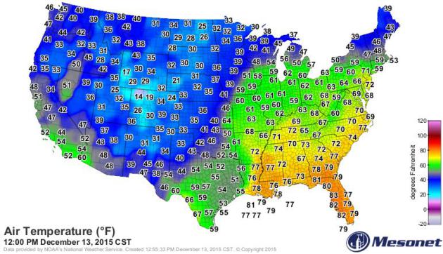
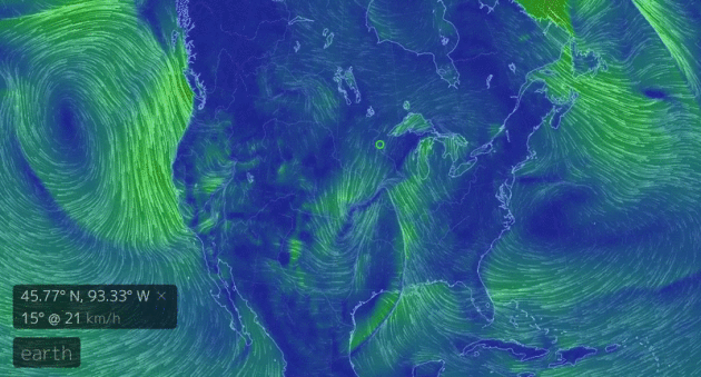
A Springlike December Day.
Check out the temperatures yesterday at noon eastern time, a streak of
60s and 70s as far north as New York City; remarkable warmth,
considering the sun reaches it's lowest angle one week from today.
Source:
Oklahoma Mesonet.
Odd Pattern for Mid-December.
The maps still look like something out of mid-March, and even though
seasonably cold air returns later this week we warm back up to 40F again
as early as Sunday; a streak of days in the 30s to near 40F next week.
Merry (slushy) Christmas! Source:
earth.nullschool.net.
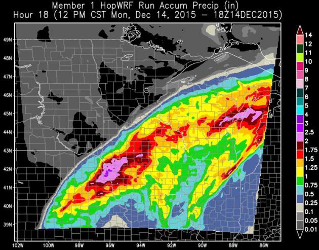
HopWRF: Heaviest Precipitation Bands to Stay Just South and East of MSP.
It may be a close call, according to 3 KM WRF model runs, showing some
1" amounts over the far southern suburbs, but little or no rain from
Willmar to St. Cloud. Expect a sharp gradient of precipitation amounts
along the deformation zone.
Pretty Typical: For Mid-March.
A surge of southern moisture (precipitable water values incredibly high
for mid-December) pushes heavy rain bands across Iowa, southeastern
Minnesota and Wisconsin, with some 2"+ amounts expected closer to Winona
and Rochester. NAM guidance: NOAA and AerisWeather.
Slushy Ending?
NAM guidance continues to hint at a period of sleet (ice pellets) or
wet snow as the column of air overhead begins to cool. Temperatures are
forecast to be above 32F between 4,000 and 7,000 feet, rain drops
re-freezing into ice pellets, possibly heavy wet snow by late morning or
midday.
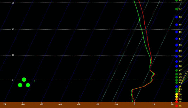
Sleet and Slush Potential.
Although temperatures a mile up are (just) above freezing a cold layer
near the ground may turn a cold rain over to ice pellets, even a few
hours of slushy snow by midday. Predicted Skew-T temperature profile
this morning courtesy of Bufkit and NOAA.
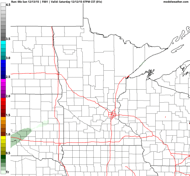
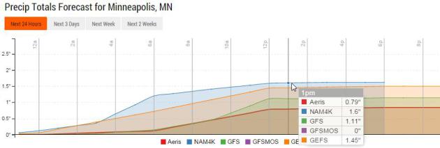
Wide Model Spread.
I'm still not convinced the downtowns will pick up an inch or more of
precipitation (although at this point nothing would shock me). Models
print out anywhere from .79" to 1.45" for the GFS ensemble. I suspect
the heaviest precipitation bands will set up south/east of MSP. Source:
Aeris Enterprise.
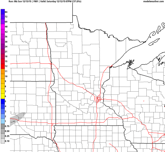
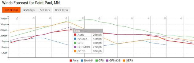
Another Bad Hair Day.
One thing is fairly certain: winds will be howling today; sustained
winds as high as 30 mph with gusts reaching 40 as air accelerates into
an intensifying storm tracking to our south and east. Then again, it
could be windier...
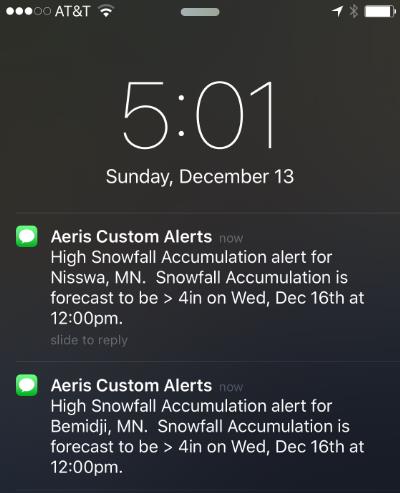
Enough to Plow Up North on Wednesday?
Not here in the metro, but our internal models alerted on the
possibility of a plowable accumulation Wednesday from Brainerd to
Bemidji. Yes, it would be nice to get some snow on the ground in time
for Christmas. Source: Aeris Enterprise Mobile.
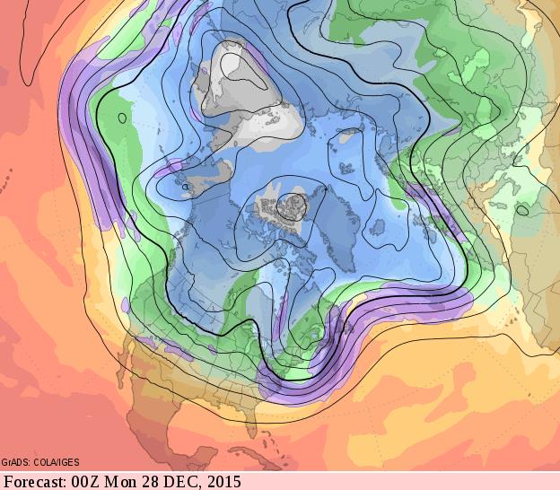
Late December: Modified Zonal Flow.
It still doesn't look polar, although a few models bring a push of much
colder air into Minnesota in time for New Year's Eve. The evening of
Sunday, December 27 shows a westerly fetch from the Pacific;
temperatures at or a few degrees above average.
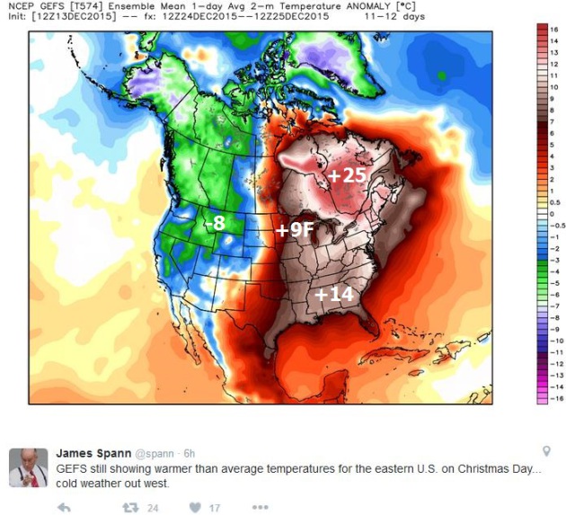
Christmas Day Temperature Anomalies.
It's still a long way out, but NOAA's GEFS model ensemble suggests
temperatures as much as 10F warmer than average for eastern Minnesota
and Wisconsin; 25F warmer than average for much of eastern Canada as a
Pacific flow continues to dominate.
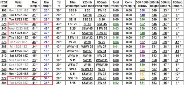
50F on Christmas Eve?
I don't buy it, not yet - but GFS guidance is hinting at high
temperatures close to 50F in the Twin Cities December 23 and 24, a
string of days in the 40s over the next 2 weeks.
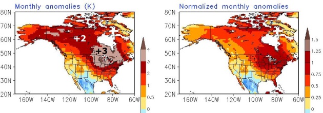
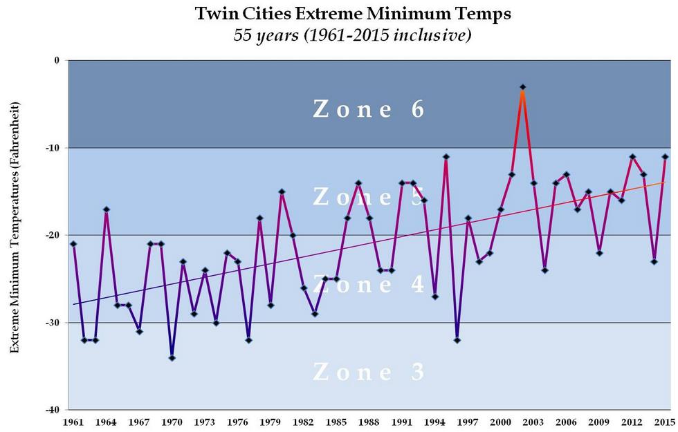 Twin Cities: Now Firmly in USDA Zone 5?
 My friend (and Edina prize-winning rose gardener) Jack Falker takes a look at the trends and implications in his blog,
The Minnesota Rose Gardener. In an e-mail he said: "
We've
been running 20 degrees above average but you also have to remember how
much that average has been pulled warmer over the last 50-plus years,
right along the trend line in my charts. So there is a compounding
effect, with above average temps pulling the average ever higher..."
Here's an excerpt of Jack's blog post that caught my eye: "...
For
several years now I have been doing 50-plus year statistical analysis
on Minneapolis-St. Paul winters and comparing them with winters in other
upper-Midwest cities. The results are pretty amazing in that we can see
very distinct warming trends developing. And it has become much easier
to predict that these trends will continue and that we will see warmer
winters going forward. The meteorological winter of 2015-16 began on
December 1st and what we are now seeing is exactly what the trend line
shows we should expect: temperatures are much warmer than average, an
average which itself has been pulled significantly upward over the last
55 years. (Above) is my chart for the 55 winters beginning in 1961,
through 2015, in the Twin Cities. What it shows is that since year 2000,
all but three of our winters have been in USDA Zone 5 or higher, even
though the USDA continues to rate MSP as Zone 4 (based on data that is
now 10 years old). What's most important here is the upward slope of the
trend-line, which, as mentioned above, is predictive. What the
trend-line shows, if you extend it, is that MSP will be firmly in Zone 6
within the next three or four years. Right now, based on what we are
seeing, I believe we will see a Zone 6 winter in 2016, for the second
time in history, and there is a distinct possibility that it could be
Zone 7, i.e. not below zero at all, which would be a first...."
* The graphic above shows the coldest nighttime low temperatures at Twin Cities International Airport since 1961.
Mild Signal To Spill into January.
At least if you believe NOAA CPC's CFS (Climate Forecast System) V2
model, which shows January temperatures as much as 3-4K, or 5-7F warmer
than average from Minnesota into the Great Lakes, as a mild Pacific flow
continues to dominate North America. Source: NOAA.
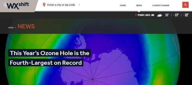
This Year's Ozone Hole is the 4th Largest on Record.
Fewer manmade chemicals (CFCs) are drifting into the stratosphere, but
natural variability may be playing a role in ozone depletion. Here's an
excerpt at
WXshift: "
The ozone hole,
an environmental problem often associated with the 1980s, is still a
clear and present issue more than 30 years later. Despite efforts to
clean up the stratosphere of ozone-depleting chemicals, this year’s
ozone hole minimum bottomed out at the fourth lowest on record.
The ozone hole this year grew to a size of 10.9 million square miles,
which is larger than the continent of North America. It’s a 1.3 million
square miles bigger than last year’s size, and is the fourth largest on record since 1991. This year the hole formed later and lasted two weeks longer than usual, leading to almost 100 percent ozone depletion..."
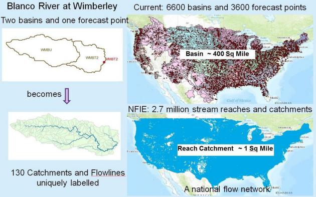
A New Way to Predict Nationally Started in central Texas "Flash Flood Alley".
KUT.org
in Austin documents on pulling in additional resources, data (and
supercomputer crunching) is helping the process of predicting record
rainfall and flooding events; here's an excerpt: "...
The system
works as a tool that predicts weather and flooding, but, unlike current
systems, it relies on a lot of different disciplines. Hydrology, which
he says connects “rain in the sky with water on the ground,” and
geography, which connects “water on the ground with flow in the
streams.” Supercomputing crunches the datasets and runs the models. “We
haven’t used supercomputing for hydrologic forecasting before,” he says.
“This is the first time that’s been done...”
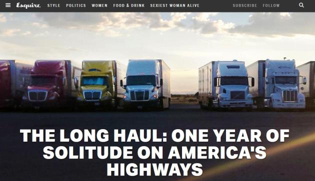
The Long Haul: One Year of Solitude on America's Highways.
Esquire takes a look at the benefits and the dark side of long-haul trucking; here's an excerpt: "...
There's
something metaphysical about driving alone through the night. As the
world slips into darkness, you enter a free-form self that is post-sleep
and incoherent. After a few hours, the parameters that separate you
from the prism of night dissolve, and only an elongated tube of light
sucks you along. And you begin to hallucinate. Under prolonged sensory
deprivation, your brain invents its own visions. Before we reached
Amarillo, I'd spent days on an acrobatic sleep schedule, trying to
weather my driving partner's erratic temper and fearing for my own
safety..."
There Once Was a Girl.
The author writes an eloquent, heart-breaking plea for understanding
and compassion, arguing against the false narratives of anorexia.
Slate has the story - here's an excerpt: "...
Even
now I worry I’m telling the story wrong. Is E unhappy? Did my parents
enable us in our sickness, or were they just powerless to reverse the
tide? I can hardly conjure those years of my life in memory without
thinking I’ve committed some grave narrative sin. I’m not the most
reliable narrator. (To be fair, you probably aren’t, either.) I spin
stories about people in order to understand them better, or to soothe or
entertain myself. I sometimes balance my sanity on unstable
materials—love objects that don’t stay put where I’ve left them. It can
be hard to accept that your “characters”—Mom, Dad, sister—don’t belong
to you, the tale-teller..."
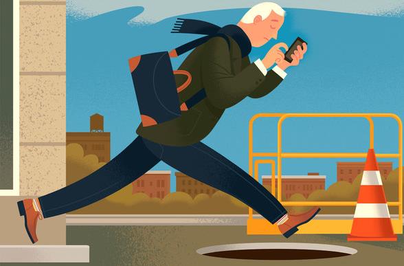
It's All About Me! Distracted Walkers Pose Threat to Self and Others. Darwin was right. Here's the intro to a story at
The New York Times: "
While
distracted driving has commanded lots of attention (albeit not a
commensurate amount of correction), another digital hazard — distracted
walking — is on the rise, with sometimes disastrous consequences. We’ve
all seen it, and often felt it, as people looking down to text, tweet,
read or play games on their smartphones crash into us, typically as we
walk in a straight line and they don’t. A study by Eric M. Lamberg and Lisa M. Muratori at Stony Brook University found that distracted walkers veer off course by as much as 61 percent while texting and walking..."
Image credit above: Paul Rogers.
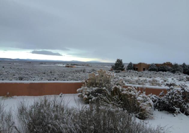
A Cold, Crystalline Version of Water: "Snow".
Just to refresh your memory. This was taken near Taos, New Mexico.
Thanks to Craig Mataczynski for reminding us what a snowy landscape
looks like.
TODAY:
Rain, ice, snow. Windy, messy and raw. Some slush is possible on lawns
and fields by afternoon. Winds: N 20-35. High: 38 (falling)
MONDAY NIGHT: Flurries taper, still gusty. Low: 33
TUESDAY: Overcast, slushy mix arrives at night. High: 37
WEDNESDAY: Slushy snow, nuisance accumulation? Wake-up: 34. High: 38
THURSDAY: Colder wind, few flurries. Icy roads. Wake-up: 25. High: near 30
FRIDAY: Coldest day of the week; windchill dips to 5F. Winds: NW 10-20. Wake-up: 15. High: 22
SATURDAY: Sunny, not as windy - or numbing. Winds: W 7-12. Wake-up: 11. High: 26
SUNDAY: Some sun, rapid thaw likely. Winds: S 10-20. Wake-up: 24. High: near 40
Climate Stories...
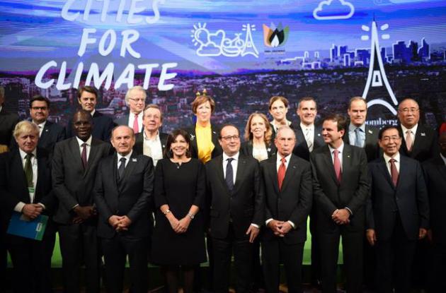
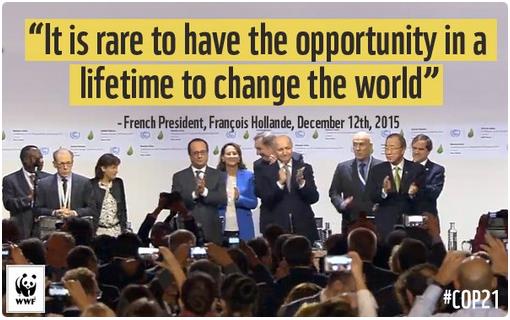
Nations Approve Landmark Climate Accord in Paris.
The New York Times reports on a landmark agreement between 195 nations; here's an excerpt: "...
The
deal, which was met with an eruption of cheers and ovations from
thousands of delegates gathered from around the world, represents a
historic breakthrough on an issue that has foiled decades of
international efforts to address climate change. Traditionally, such
pacts have required developed economies like the United States to take
action to lower greenhouse gas emissions, but they have exempted
developing countries like China and India from such obligations. The
accord, which United Nations diplomats have been working toward for nine
years, changes that dynamic by requiring action in some form from every
country, rich or poor..."
* The full text of the Paris Agreement is
here.
Photo credit: Stephane de Sakutin/Pool Photo via AP.
The One Word That Almost Sank the Climate Talks. Yes, there was (and is) continued parsing of language, which makes the lawyers happy. Here's an excerpt from
POLITICO: "
After
years of preparation and two weeks of tireless negotiations, after all
the speeches and backroom compromising, one misplaced word brought the
momentum toward a historic global deal on climate change to a halt
Saturday — for at least a few hours. Obama administration lawyers
discovered early in the day that the latest draft text had a potentially
deal-killing tweak: Deep into the document, in Article 4, was a line
declaring that wealthier countries "shall" set economy-wide targets for
cutting their greenhouse gas pollution..."
 The 5 Most Important Components of the Paris Climate Agreement
. Andrew Freedman summarizes at
Mashable; here's an excerpt: "...
The
deal is a turning point for climate policy, since it brings the entire
globe under the same policy framework, rather than only placing mandates
on industrialized nations. It is also a triumph of the concept of
multilateralism, and a demonstration that countries with wildly
differing interests can in fact come together to address a common
concern. But the agreement alone will not solve global warming; it will
not stem the rising tides nor cool the sizzlingly hot heat waves that
are becoming more prevalent. Instead, it will send a signal that the
world is moving away from fossil fuels, and toward renewable energy. It
will be up to the activists, investors, inventors and future world
leaders to ensure that this agreement translates into real progress..." (Image above: NASA).
Climate Accord Draws Mixed Reaction from Business Leaders. Here's a clip from a story at
The New York Times: "...
If
nothing else, analysts and experts say, the accord is a signal to
businesses and investors that the era of carbon reduction has arrived.
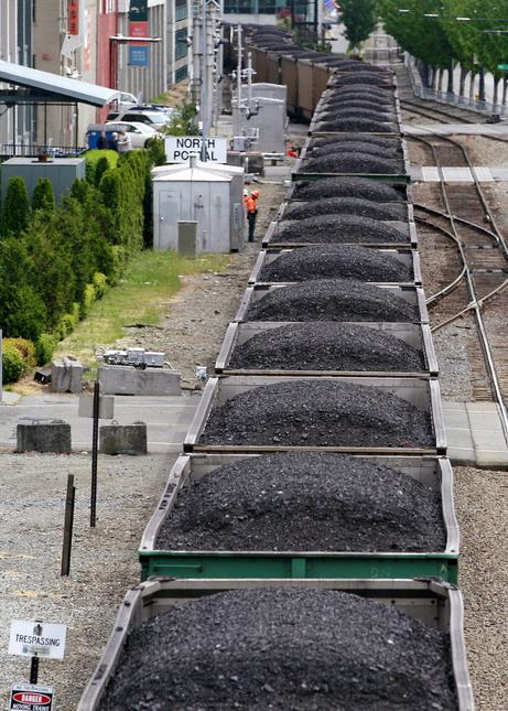
It will spur banks and investment funds to shift their loan and stock
portfolios from coal and oil
to the growing industries of renewable energy like wind and solar.
Utilities themselves will have to reduce their reliance on coal and more
aggressively adopt renewable sources of energy. Energy and technology
companies will be pushed to make breakthroughs to make better and
cheaper batteries that can store energy for use when it is needed. And
automakers will have to develop electric cars that win broader acceptance in the marketplace..."
What the Global Climate Accord Means for You.
Not tapping dirty coal will hurt the U.S. economy? Not so much, it
turns out. The smart money is already on renewables and energy storage.
USA TODAY has a worthy read; here's an excerpt: "...
That's
partly because Americans are discovering there's little trade off
between protecting the environment and creating jobs, says Alden Meyer,
strategy director for the Union of Concerned Scientists. The drive
toward reducing greenhouse gases has created new technologies and
industries to support them. The Paris agreement "sends a powerful
message (that the) smart money ought to be betting on the clean-energy
future," Meyer says..."
Now Comes the Tough Part: The Word's Carbon Diet Starts.
AP takes a look at the efforts required to wean (all of us) off of fossil fuels; here's a clip: "
The
world is about to go on a carbon diet. It won't be easy — or cheap.
Nearly 200 nations across the world on Saturday approved a
first-of-its-kind universal agreement to wean Earth off fossil fuels and
slow global warming, patting themselves on the back for showing such
resolve. On Sunday morning, like for many first day dieters, the reality
sets in. The numbers — like calorie limits and hours needed in the gym —
are daunting. How daunting? Try more than 7.04 billion tons (if you
really want to have your eyes bug out, that's 15.5 trillion pounds).
That's how much carbon dioxide needs to stay in the ground instead of
being spewed into the atmosphere for those reductions to happen, even if
you take the easier of two goals mentioned in Saturday's deal. To get
to the harder goal, it's even larger numbers..."
The Power of Paris: Climate Challenge Remains, But Now We're on the Right Path. Climate scientist Michael Mann provides his perspective at
The World Post: "...
Paris
is a beginning of a process. It provides a framework for continued
progress toward the goal of averting dangerous interference with our
climate. Put into more technical terms, the Paris agreement gets us roughly halfway
to where we need to be. A future path of business-as-usual carbon
emissions would likely warm the planet about 5 degrees Celsius (9
degrees Fahrenheit). The reductions agreed upon in Paris reduce that to
about 3.5 degree Celsius (6.3 degrees Fahrenheit), i.e. halfway down to
limiting to 2 degrees Celsius (3.6 degrees Fahrenheit) warming, the
level of warming that many scientists studying the impacts of climate
change consider to be unsafe..."
Falling Short on Climate in Paris. Climate activist Bill McKibbon isn't celebrating just yet - here's an excerpt of his Op-Ed at
The New York Times: "...
So
the world emerges, finally, with something like a climate accord,
albeit unenforceable. If all parties kept their promises, the planet
would warm by an estimated 6.3 degrees Fahrenheit, or 3.5 degrees
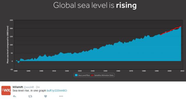
Celsius, above preindustrial levels. And that is way, way too much. We
are set to pass the 1 degree Celsius mark this year, and that’s already
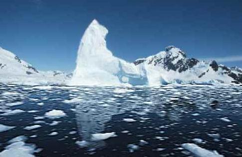
enough to melt ice caps and push the sea level threateningly higher. The
irony is, an agreement like this adopted at the first climate
conference in 1995 might have worked. Even then it wouldn’t have
completely stopped global warming, but it would have given us a chance
of meeting the 1.5 degree Celsius target that the world notionally
agreed on..." (File photo: Elaine Thompson, AP).
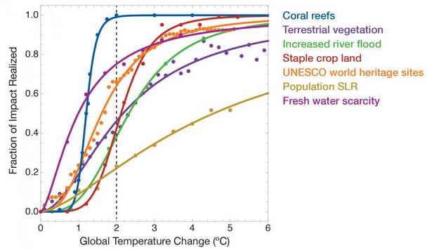
Most Climate Change Damage Will Happen Before the 2-Degree Temperature Threshold. Additional warming is already baked into the calculations, according to an analysis at
Newsweek; here's an excerpt: "...
In
the chart below, Caldeira and his colleagues graphed the extent of
damage from climate change on various sectors of the environment. They
found that the sensitivity of some of these categories to small
increases in temperature will be highest within the first several
degrees of warming, and then tapers off, having hit a physical limit, or
what the researchers call a “saturation of impacts,” as in the case of
coral reefs at two degrees Celsius. Once the planet gets into the higher
degrees of warming, the rate of impact begins to plateau—because there
won't be anything left to be affected..."
Graph credit above: "
Some
climate change impacts rise fast with little warming, and then taper
off, write a team of researchers in a paper published during the 2015
Paris climate talks." Ricke et al/NATURE GEOSCIENCE.
Decoding the Paris Climate Deal: What Does it Mean? While
some question whether the sky is blue (or warming) nations of the world
have entered into a legally binding agreement to try and keep global
temperatures below, hopefully "well below" 2C of warming. More
perspective and analysis on an historic accord at
Climate Home: "
A two-week climate conference in Paris ended on Saturday with the first universal agreement on climate change.
Some 186 countries have made national pledges for climate action, and
agreed a global long-term goal to phase out greenhouse gas emissions,
marking a turning point in the fossil fuel era.
The Paris outcome has two documents.
- The
all-important, 12-page document “Paris Agreement”, which sets out new
commitments for climate action beyond 2020, and potentially through this
century.
- An accompanying, 19-page “Decision” which
adds the legwork that countries will have to undertake before the
Agreement enters into force in 2020.
Following is an analysis of the outcome..."
In Historic Paris Climate Deal, World Agrees to Not Burn Most Fossil Fuels. More context at
ThinkProgress; here's an excerpt: "
In a literally world-changing deal that was almost unthinkable just a year ago, some two hundred leading nations unanimously embraced a plan
that will leave most of the world’s fossil fuels unburned. As part of a
concerted effort to avoid catastrophic climate change, the world
unanimously committed to an ongoing effort of increasingly deeper
emissions reductions aimed at keeping total warming “to well below 2°C
[3.6°F] above preindustrial levels.” The full text of this Paris Agreement
goes even further, with the parties agreeing “to pursue efforts to
limit the temperature increase to 1.5°C above preindustrial levels,
recognizing that this would significantly reduce the risks and impacts
of climate change...”
* Digg.com has an overview of the summit agreement
here.
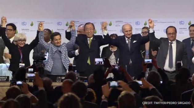
World Climate Accord Hailed as Turning Point from Fossil Fuels.
Reuters has the story; here's the introduction: "
French
Foreign Minister Laurent Fabius presented a landmark global climate
accord on Saturday, a "historic" measure for transforming the world's
fossil fuel-driven economy within decades and turning the tide on global
warming. At the tail end of the hottest year on record and after
four years of fraught U.N. talks often pitting the interests of rich
nations against poor, imperiled island states against rising economic
powerhouses, Fabius urged officials from nearly 200 nations to support
what he hopes will be a final draft..."
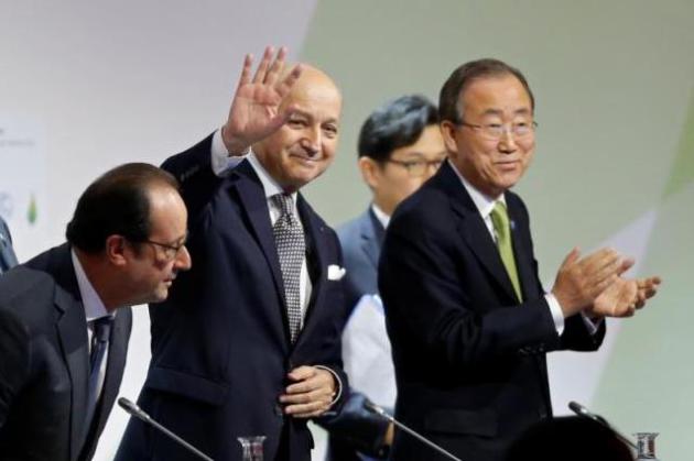
Photo credit above: "
French
President Francois Hollande (L) takes his seat at a plenary session
with Foreign Affairs Minister Laurent Fabius (C), President-designate of
COP21, and United Nations Secretary-General Ban Ki-moon at the World
Climate Change Conference 2015 (COP21) at Le Bourget" Photo: Reuters/Stephane Mahe.
No comments:
Post a Comment