_______________________________________________
90 Degree Days So Far This Year
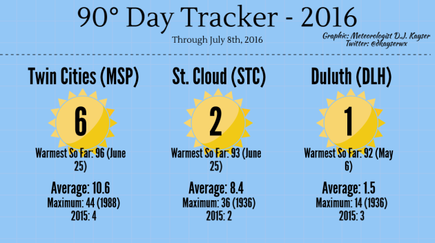
Speaking
of 90 degree days, we have hit 90 six times so far this summer here in
the Twin Cities, already blowing away the total number of 90s we had
last year (four). The warmest day we've seen was 96 back on June 25. St.
Cloud has only seen two so far, with Duluth managing to hit it once -
back in May!
_______________________________________________
80th Anniversary of the 1936 Heat Wave
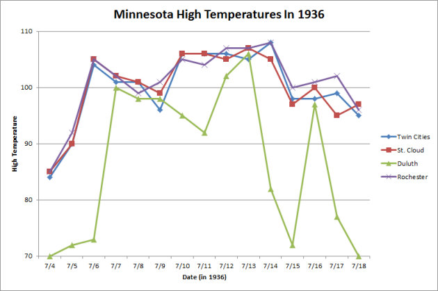
This
week marks the 80th anniversary of the worst heat wave in Minnesota
history back in 1936, when highs for a good majority of 1-2 weeks were
in the 100s across the region. Many of these records still are in place
today, and this heat wave brought the warmest high ever record in the
Twin Cities - 108 degrees on July 14th. Not only was the warmest
temperature on record at the Twin Cities recorded during this stretch,
but at St. Cloud (107 on the 13th which is also tied with two days from
1934), Duluth (106 on the 13th), and Rochester (108 on the 14th) as
well. The warmest Minnesota temperature on record was also tied in this
heat wave, when it reached 114 on July 6th, 1936 in Moorhead.
Here's a recap of the heat wave from Mark Seeley's WeatherTalk blog last week: "It
started in southern counties on July 4, 1936 with many observers
reporting daytime temperatures over 100F. The Heat Wave spread north
over the next 12-15 days. Even northern communities reported
temperatures close to 100F, and nighttime temperatures remained in the
80s F in many areas, falling into the 70s F near lakes and in low lying
areas. There was no respite from the heat, as many citizens chose to
sleep outside. It is estimated that this Heat Wave caused over 900
deaths in Minnesota and at least 5000 deaths across the nation. It was
also combined with serious drought."
_______________________________________________
No Heat Waves, Just Occasional "Heat Spikes"
By Paul Douglas
“I
drifted into a summer-nap under the hot shade of July, serenaded by a
cicada lullaby, to drowsy-warm dreams of distant thunder” wrote Terri
Guillemets.
July is full-frontal summertime
with no apologies; the warmest month of the year. In fact this is,
historically, the warmest week of the year across Minnesota. We'll see
90s Monday, maybe a few days above 90F in a week, but I still don't see an extended stretch of 90s - or worse.
Dr.
Mark Seeley reports July 6-15, 1936 brought incessant, broiling heat
across the state. 175 deaths in the Twin Cities were blamed on extreme
heat - 760 to 900 heat-related fatalities statewide.
Today
looks sticky with enough sunshine to season a thundery, tropical stew. A
few T-storms may turn severe later on. Expect 90-95F tomorrow; another run of 90s early next week.
NOAA's
GFS model tries to carve out a ridge of hot high pressure over the
Midwest by late July, but squirts of cooler, drier, tolerable air
continue to dribble out of Canada, preventing any extended, debilitating
heat waves close to home for at least the next 2 weeks.
_______________________________________________
Extended Forecast for Minneapolis
SUNDAY: T-storms, some severe. High 86. Low 73. Chance of precipitation 70%. Wind SE 10-20 mph.
MONDAY: Stinking hot, feels like 100F. High 92. Low 72. Chance of precipitation 40%. Wind S 10-20 mph.
TUESDAY: Warm sun, slightly less humid. High 88. Low 68. Chance of precipitation 20%. Wind SW 10-15 mph.
WEDNESDAY: Intervals of sun, more comfortable. High 83. Low 63. Chance of precipitation 20%. Wind NW 10-15 mph.
THURSDAY: Plenty of sunshine, pleasant. High 81. Low 64. Chance of precipitation 10%. Wind NW 7-12 mph.
FRIDAY: Some sun, isolated T-storm. High 85. Low 66. Chance of precipitation 40%. Wind S 7-12 mph.
SATURDAY: Sticky sun, passing T-shower. High 87. Low 74. Chance of precipitation 40%. Winds S 10-15 mph.
_______________________________________________
This Day in Weather History
July 10th
July 10th
2002:
Intense rainfall causes extensive street flooding in St. Cloud. 2.70
inches of rain falls in 1 hour and 45 minutes at St. Cloud State
University. People were stranded in their cars and had to be rescued by
the fire department.
_______________________________________________
Average Temperatures & Precipitation for Minneapolis
July 10th
Average High: 84F (Record: 106F set in 1936)
Average Low: 64F (Record: 49F set in 1996)
Average Precipitation: 0.13" (Record: 1.93" set in 2002)
________________________________________________
Sunrise/Sunset Times for Minneapolis
July 10th
Sunrise: 5:37 AM
Sunset: 9:00 PM
*Length Of Day: 15 hours, 22 minutes and 44 seconds
*Daylight Lost Since Yesterday: ~1 mins & 20 secs
*Next Sunrise That Is Before 6 AM: August 3rd (6:01 AM)
*Next Sunset That Is Before 9 PM: July 11th (8:59 PM)
________________________________________________
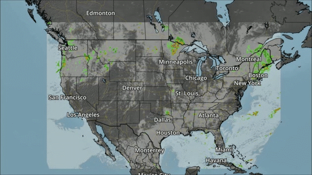
Sunday And Beyond Minnesota Weather Outlook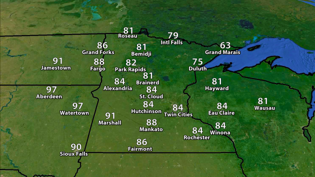
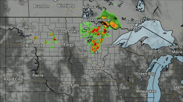
NAM forecast precipitation and clouds every three hours between 7 AM Sunday and 7 AM Monday.
The
NAM is hinting at storms across the region during the day on Sunday
across the region, a few of which could be on the strong side.
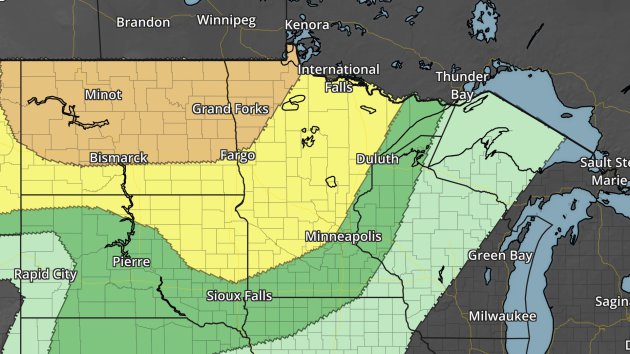
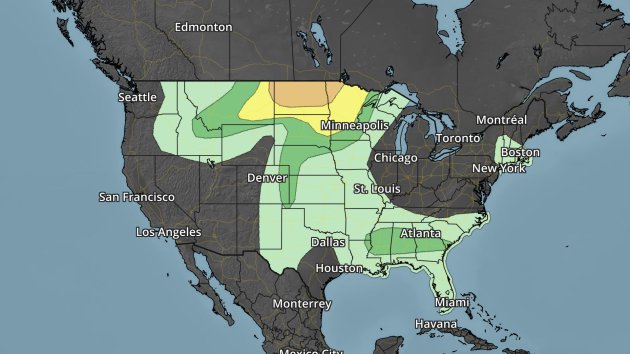
Severe risk Sunday. Dark green - marginal threat. Yellow - slight threat. Orange - enhanced threat.
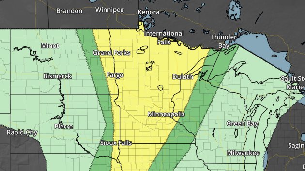
Severe risk Monday. Dark green - marginal threat. Yellow - slight threat.
With
that warm front continuing to move east, severe weather will be
possible across much of Minnesota Monday afternoon and evening. Large
hail, damaging winds and even a few tornadoes will be possible before
everything merges into a line, more capable of damaging winds during the
evening.
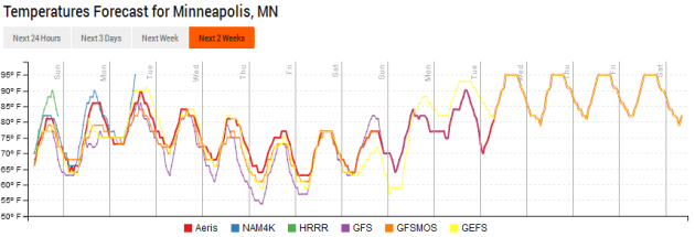
We'll
continue to warm up heading into early next week before a cool front
moves through, knocking temperatures down into the 70s by the end of the
week. Long term forecasts show a start warm up heading into the third
full week of July, with the potential of 90-95+ temperatures by the
19th.
________________________________________________
National Forecast Outlook And Stories
NAM forecast precipitation and clouds every three hours between 7 AM Sunday and 7 AM Monday.
In
addition to the storms over the Northern Plains, we'll be watching for
some showers and storms across the Northeast, Southeast and into the
Northwest on Sunday.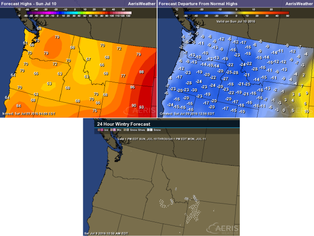
What is interesting in the Northwest will be the temperatures along with the precipitation, which will be a good 10-30 degrees below average for this time of year. There's the potential that, in higher elevation areas across Idaho, Montana, and Wyoming, some snow may be possible Sunday Night.
Severe risk Sunday. Dark green - marginal threat. Yellow - slight threat. Orange - enhanced threat.
Excessive Rain To Begin July
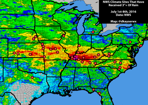
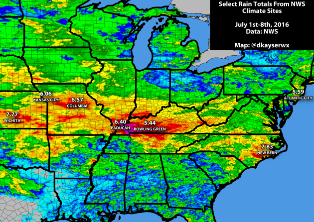
- Wichita, KS: 7th wettest
- Columbia, MO: 13th wettest
- Paducah, KY: 16th wettest
- New Bern, NC: 21st wettest
- Atlantic City, NJ: 24th wettest
- Kansas City, MO: 28th wettest
- Bowling Green, KY: 39th wettest
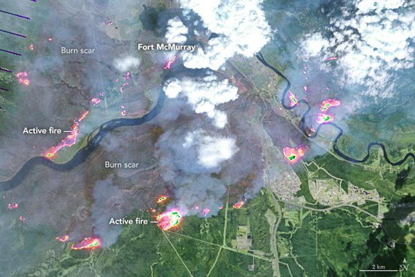
Satellite image of Fort McMurray fire back on May 4th. Image: NASA.The Insurance Bureau of Canada said on Thursday that the wildfire back in May in northern Alberta (in the Fort McMurray area) is now "the costliest insured natural disaster in Canadian history" with damage estimated at $3.58 billion. The previous Canadian costliest natural disaster was $1.7 billion from the 2013 southern Alberta floods. Climate Central has more: "The wildfire, which ignited May 1 in eastern Alberta and was brought under control on July 5, forced Canada’s largest-ever evacuation. It scorched more than 1.4 million acres and destroyed 2,400 homes and other buildings in and around Fort McMurray, the hub of Canada’s oil sands industry."
________________________________________________
Thanks for checking in and have a great Sunday! Don't forget you can follow me on Twitter (@dkayserwx) or on Facebook (Meteorologist D.J. Kayser)!-D.J. Kayser

No comments:
Post a Comment