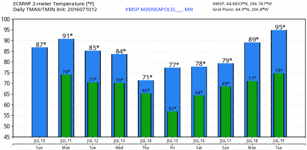
82 F. high on Sunday at KMSP.
84 F. average high on July 10.
85 F. high on July 10, 2015.
.40" rain fell at MSP International Airport Sunday.
July 11, 1903: The temperature plummets down to 26 at Leech Lake Dam.
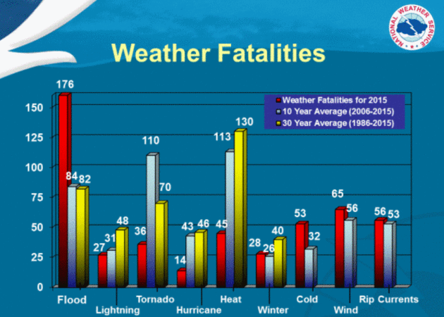
Extreme Heat: America's Number One Weather Killer
Thousands
of Americans chase tornadoes, for profit or just a cheap adrenaline
rush. Hurricanes are mesmerizing on weather satellites, threatening
entire states with flooding. But the number one killer in the USA is
heat.
30-year data from NOAA
confirms that heat consistently claims more lives than flooding,
lightning, or extreme storms. Since 1986 an average of 130 Americans
have succumbed, directly or indirectly, to excessive heat - more than 3
times the death toll from winter cold and storms.
Cooling degree data since
June 1
shows we've spent 13 percent more than average to cool our homes and
offices. And weather models, increasingly, hint at a simmering ridge of
hot high pressure stalling over the Upper Midwest the last 10 days of
July. I could see a string of 90s next week, with a heat index topping
100F at times. Summer heat has yet to peak in our zip code - I suspect
'16 will wind up considerably hotter than last summer.
We get a
little preview today: 90F with a few severe storms later on. Enjoy a
late week cool front because prime time summer arrives next week.
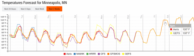
Please Let This Be a Supercomputer Hiccup, a Digital Typo.
Long-range GFS ensembles are hinting at 100-degree heat by the end of
next week as the blast-furnace ridge of high pressure scorching the west
drifts eastward. Confidence levels are still low, but we should
probably keep an eye on the model trends over time. Source: NOAA and
Aeris Enterprise.
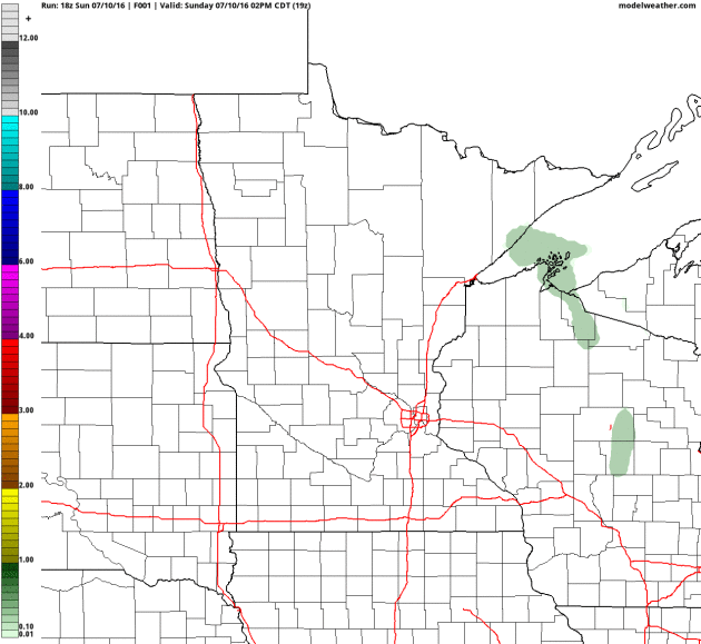
Heaviest Rains Track North of MSP Today.
There's a slight risk of severe storms today; and 4 km NAM guidance
prints out the heaviest rainfall amounts over far northern Minnesota by
Wednesday morning. When there's this much moisture in the air with dew
points in the 70s the rain can come down hard; an inch or two in under
an hour. Source: AerisWeather.
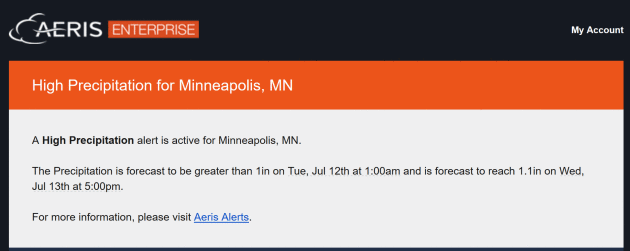
Another Inch of Rain for the Twin Cities? Our internal models sent out the alert (above) calling for a high probability of an inch of rain by 1 am Tuesady morning.
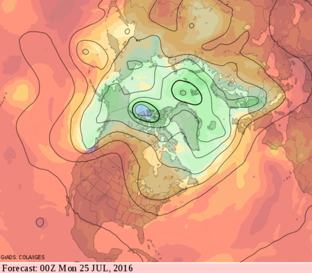
Welcome Puff of Canadian Comfort - then Beastly Hot Next Week?
European (ECMWF) model guidance shows 90 degrees today, but significant
cooling by the end of the week. Soak up a little Canadian refreshment
because seriously stinking hot weather may return next week. Graphic:
WeatherBell.
Late July: Moderately Hot Weather Continues.
Although the ridge axis stretches from Alberta and Montana into the
Rockies and western Plains within 2 weeks the map above insinuates 90s
into the last week of July.
June Weather Recap. Moisture around the state is pretty close to average, with a few exceptions. Here's an excerpt from the latest
HydroClim Minnesota, from the MN DNR and State Climatology Office: "...
Precipitation
totals in June were above normal in northeast and southeast Minnesota
and below normal for the rest of the state. The driest locations were
located in west central Minnesota where the deficit was about 2.27
inches short of normal. The driest spot was Browns Valley in Traverse
County. The June precipitation total there was only .57 inches or 3.21
inches short of the June normal. The wettest areas were in the northeast
where the average departure was 1.69 inches above normal. Grand Portage
in Cook County was one of the wettest locations with a June total of
8.34 inches of rain for the month, or 4.81 inches above normal..."
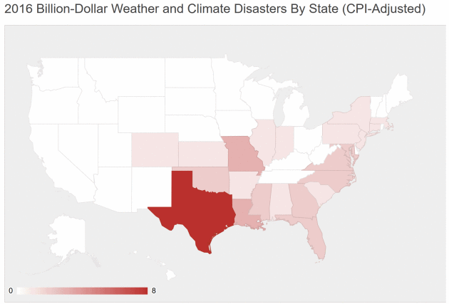
8 Billion-Dollar Weather Disasters So Far in 2016. Here are a couple of excerpts from
Cattle Network: "
The
weather can be cruel, and it can be costly. So far in 2016, eight
distinct events caused $13.1 billion in total damages and claimed 30
lives....According to NOAA,
there were 10 distinct billion-dollar weather events in all of 2015 and 8
in 2014. For more information, visit www.ncdc.noaa.gov/billions/events."
* NOAA NCDC has the list here.
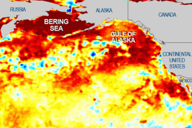
"The Blob", A Pacific, Warm-Water Mass That Caused Weather Havoc, Is Back. It may have never completely gone away, according to OregonLive: "...It's
likely behind the West Coast's warm winters and record-low snowpack
levels in 2014 and 2015, oceanographers at the National Oceanic and
Atmospheric Administration and the Canadian Department of Fisheries and
Oceans found. And Dennis Hartmann, a professor of atmospheric sciences
at the University of Washington, suggested
it might have pushed cold, wet air east, causing the East Coast's
"polar vortex" winters that blanketed cities in record snowfalls. In
fact, NOAA researchers found, the blob has had a greater effect on
conditions than El Niño, a better-known warming effect in the ocean and
atmosphere..." (Map credit: NOAA).
4 in 10 Highly Rated Sunscreens Don't Meet Academy of Dermatology Guidelines.
The Washington Post reports; here's a clip: "...
He
said many of the consumers writing reviews tended to focus on more
superficial issues such as smell or feel or on the sunscreen’s value as a
cosmetic rather than on its actual sun protection. That may be because
sunscreens are no longer stand-alone products, but come in every form of
moisturizer and makeup on the market. The ubiquity of sunscreens has
made it easier than ever before for consumers to use the products, but
it's also created a lot of confusion..."
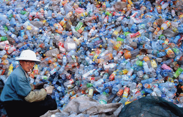
Stop Drinking Bottled Water. A bad habit I need to break as well. Here's a clip from
Gizmodo: "...
Clean,
safe drinking water that flows freely out of our faucets is a feat of
engineering that humans have been been perfecting for two millennia. It
is a cornerstone of civilization. It is what our cities are built upon.
And over the years the scientists and hydrologists and technicians who
help get water to our houses have also become our environmental
stewards, our infrastructural watchdogs, our urban visionaries. Drinking
the water these people supply to our homes is the best possible way to
protect future access to water worldwide. Even after public water crises like Flint—especially after public crises Flint. Companies that package water in a single-use bottle are not concerned with the future..." (Image:
change.org).
Many Parents Will Say Kids Made Them Happier.
They're Probably Lying. No regrets here, but an article at
The Washington Post caught my eye; here's an excerpt: "...
The
United States provides minimal assistance to parents, including paid
parental leave, mandatory paid sick and vacation days, subsidized child
care, and work schedule flexibility, they say. And parenthood is also
unusually expensive in the United States, due to the high cost of
private education and a lack of public subsidies for childcare. In 2012,
the U.S. Department of Agriculture estimated
that a middle-income American family is likely to spend $234,900 to
raise a child born in 2011 to age 17. If the kid goes to college, that
figure may double. In contrast, countries like Norway, Sweden, Finland
and France have extensive social safety nets and supportive family
policies, Glass says..."
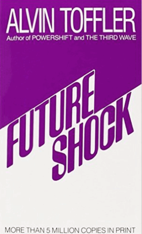
Why We Need to Pick Up Alvin Toffler's Torch.
Future Shock has arrived. Globalization. Automation. Computerization.
Robots. Artificial Intelligence. No wonder so many of us are feeling
disoriented, underemployed and worried for the future. Here's an excerpt
at
The New York Times: "...
Yet
in rereading Mr. Toffler’s book, as I did last week, it seems clear
that his diagnosis has largely panned out, with local and global crises
arising daily from our collective inability to deal with ever-faster
change. All around, technology is altering the world: Social media is
subsuming journalism, politics and even terrorist organizations. Inequality, driven in part by techno-abetted globalization, has created economic panic across much of the Western world. National governments are in a slow-moving war for dominance with a handful of the most powerful corporations the world has ever seen — all of which happen to be tech companies..."

Pilot Captures Incredible Nighttime Thunderstorm Photo Over the Pacific Ocean. Tip of the hat to
Capital Weather Gang for sharing one of the more amazing CB photos I've ever seen: "
This
is one of the most striking thunderstorm photos we’ve seen. Taken from a
plane at the moment of a lightning flash, it illustrates both the
ferocity of a turbulent atmosphere and the beauty of Mother Nature. A
strong, roiling updraft; a smooth, flat anvil; and the overshooting top —
all features of intense developing thunderstorms. The photo was taken
over the Pacific Ocean from the cockpit of an airplane. The photographer
and pilot, Santiago Borja, says he was circling around it at 37,000
feet altitude en route to South America when he captured this
spectacular view..."
Photo credit: "
A developing thunderstorm climbs high into the atmosphere over the Pacific Ocean south of Panama." (Santiago Borja).
Is This The World's Craziest New Skyscraper? CNN Architecture has details: "...In line with that philosophy, MahaNakhon
-- Scheeren's pixelated vision of a luxury mixed-use tower situated in
Bangkok's business district -- looks little like the rest of his
repertoire. Based on the shape of an extruded square, the building's
central tower rises up and connects a large number of small-scale
geometric extrusions to create the image of an unfinished building, or a
Jenga game in progress. "MahaNakhon is a vision of a tower that is very
much about process, about becoming, about developing," Scheeren says of
the building..."

 TODAY
TODAY: Steamy, strong T-storms possible, a few may turn severe. Winds: S 15-25. High: 91
MONDAY NIGHT: T-storms likely, locally heavy rain. Low: 71
TUESDAY: Damp start, then warm sunshine. Winds: SW 10-15. High: 87
WEDNESDAY: Less sun, stray T-storm or two. Winds: W 10-20. Wake-up: 68. High: 84
THURSDAY: Mostly cloudy, cooler. Few showers and sprinkle. Winds: NW 10-15. Wake-up: 63. High: 72
FRIDAY: Sunny and pleasant. Comfortable dew points. Winds: S 5-10. Wake-up: 58. High: 78
SATURDAY: Few showers and T-storms. Winds: SE 7-12. Wake-up: 60. High: 80
SUNDAY: Sticky sun, few T-storms. Wake-up: 67. High: 84
* A friend snapped the photo of the Bald Eagle clutching a walleye (?) up at Pelican Lake over the 4th of July weekend.
Climate Stories...
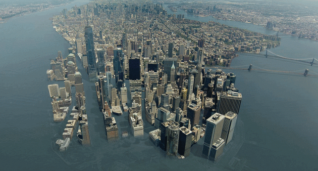
Can New York Be Saved In The Era of Global Warming. Jeff Goodell reports at
Rolling Stone; here's an excerpt: "...
The
problem for New York is, climate science is getting better and better,
and storm intensity and sea-level-rise projections are getting more and
more alarming," says Chris Ward, the former executive director of the
Port Authority of New York and New Jersey, the agency in charge of
airports, tunnels and other transportation infrastructure. "It
fundamentally calls into question New York's existence. The water is
coming, and the long-term implications are gigantic..."
Image credit: "
As sea levels rise in the next century, even a $3 billion wall won't keep Lower Manhattan above water."
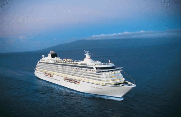
Arctic Cruise Raises Hopes and Environmental Concerns. Yes, let's cruise NORTH of Canada and admire a rapidly-melting arctic.
Alaska Dispatch News has the story; here's a clip: "...
There
are few opportunities for passengers to travel the sea route along the
northern coast of North America. Even with global warming opening up the
Northwest Passage, fewer than 50 passenger ships have completed the
full transit, and those were largely yachts and expedition boats with at
most a few hundred people. With 1,070 passengers and a crew of 655, the
Serenity is giant in comparison. Its foray into these waters will test
not only the ability of man and machine to avoid ice, but also the
readiness of a multinational search and rescue coalition..."
Photo credit: "The 1,077 passenger capacity Crystal Serenity is planning a 32-day voyage through the Northwest Passage in the summer of 2016." (Courtesy Crystal Cruises).


No comments:
Post a Comment