NORAD Santa Tracker
The fine folks over at NORAD are tracking Santa once again and he's well on his way. Old Saint Nick will experience some inclement weather across the US this year as a storm system works through the western half of the country. Hope Kris Kringle has those presents strapped on tight... turbulence will be a concern as upper level winds look pretty strong as the storm digs into the Central US through early Sunday.
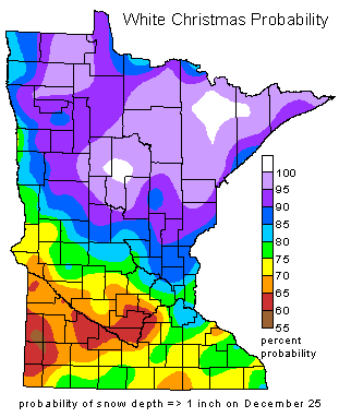
Historical Chances of a White Christmas in Minnesota
As of midday Saturday, December 24th, there was 4" of snow on the ground at the Minneapolis International Airport. In order to be an official White Christmas, there needs to be at least 1" of snow on the ground on Christmas Day. With that said, we need to not melt more than 3" of snow by Sunday and Christmas 2016 will go down in the books as white. Regardless, if it's white or not, weather won't be very ideal this year. Here's an excerpt from the MN State Climatology Office regarding the historical chances of a white Christmas:
"The chances of having a white Christmas vary even here in Minnesota. Having a white Christmas is loosely defined as having 1 inch of snow on the ground on Christmas Day. In 116 years of snow depth measurements in Twin Cities, a white Christmas happens about 72% of the time. From 1899 to 2015 there have been 34 years with either a "zero" or a "trace." The last time the Twin Cities has seen a brown Christmas was 2015. 2014 was also a "brown Christmas." The deepest snow cover on December 25th was in 1983 with a hefty 20 inches. It was also a very cold Christmas in 1983, with the high temperature of one (1) degree F."
_________________________________________________________________________________
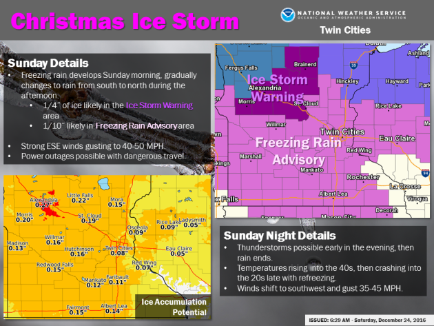
Merry Christmas to all and to all a whacky Christmas forecast...
Come on man... You've got to be kidding me! Is it too much to ask for a little light snow on Christmas Day? Good grief. The weather map is light up light a Christmas tree as a powerful storm system moves through the region on Sunday. Much of Minnesota will be on the 'warmer' side of the storm, which means a messy mix of freezing rain and sleet will transition to rain (heavy at times) with a few rumbles of thunder! If you're travel plans take you out and about through the first half of the day Sunday, be advised that roads could be VERY slick with some spots seeing ice accumulations of up to 1/4", especially through central MN where an ICE STORM WARNING has been issued. Note that the Twin Cities and most of southern Minnesota is under a FREEZING RAIN ADVISORY, where ice accumulations of up to 0.10" to 0.20" will be possible. Gusty winds could be a catalyst for power outages as Ice accumulates on elevated surfaces like trees and power lines. I wouldn't be surprised if a few Christmas hams go cold from St. Cloud to Morris to Alexandria to Brainerd... Let's hope that's not the case. Here's an excerpt from the NWS Twin Cities regarding the messy Christmas Day storm.
"Freezing rain will develop Sunday morning and continue into the early to mid afternoon before turning to rain as temperatures warm toward 40. Ice accumulations of 1/10 to 1/4 inch are likely, with the heaviest amounts northwest of St. Cloud and near Alexandria and Little Falls. Thunderstorms become likely during the afternoon and early evening before rain ends late evening. Strong east southeast winds gusting to 40-50 mph Sunday will become southwest Sunday night."
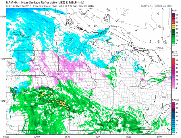
Simulated Radar
Here's a look at the highly advertised storm system as it moves through the region Sunday through early Monday. The forecast is easy for those across the Dakotas as temperatures will be cold enough for ALL snow, which will be heavy with significant winds, so blizzard conditions will be found there. The forecast gets VERY complicated across Minnesota... again a mixture of messy wintry precipitation will be with much of Minnesota for much of the day. Periods of freezing rain, sleet and snow will transition to rain (heavy at times) with a few rumbles of thunder across the southern half of the state by the afternoon hours.
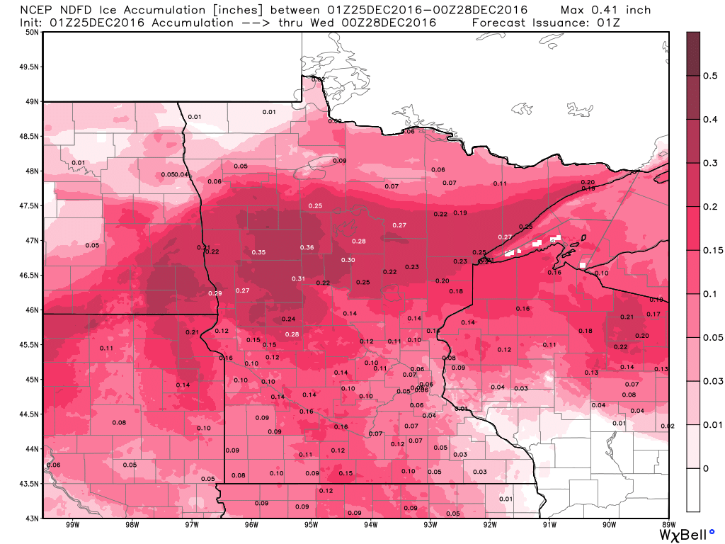
Total Ice Accumulations
Ugh... This is not what I want to see on any weather map, especially on Christmas Day. The pink colors below indicate total ice accumulations through Monday. Note that much of Minnesota will see the potential of some ice accumulations, though areas around St. Cloud to Morris to Alexandria to Brainerd could see up to 1/4" ice (0.25"), where spots south of there, including the Twin Cities, could see up to 0.10" to 0.20" ice.
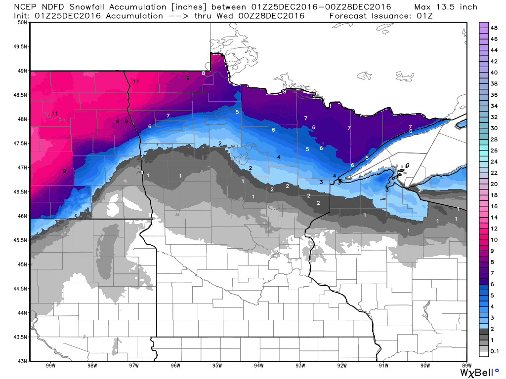
Total Snowfall Accumulations
Here's a look at the snowfall potential through 6pm Monday. Note that the Twin Cities will likely not see any accumulation as this storm system blows through. The heaviest will be found across North Dakota and far northwestern MN with some 8" to 14" amounts possible! Keep in mind that very strong winds (up to 55mph) will create whiteout conditions across much of the area. Major roads across the Dakotas will likely be closed on Christmas Day, so plan ahead!
Yes! You are seeing this correctly... that is a GENERAL thunderstorm threat for Christmas Day. Keep in mind that it is VERY rare to have thunder on Christmas Day in the Twin Cities. With that said, thunder will add the the weather weirdness on Sunday.
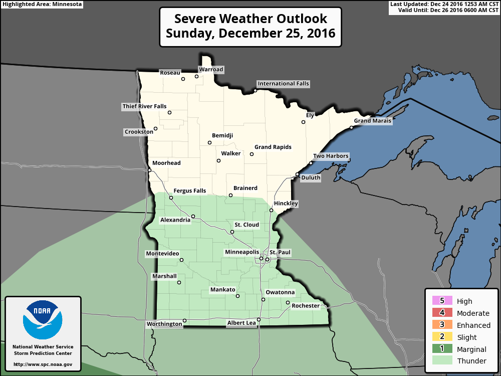
Rare Thunder Risk on Christmas Day??
Take a look at the historical numbers with thunderstorms reported in the Twin Cities. Note that the peak occurs in the spring/summer and drops off to nearly nothing in December and January. Again, to have thunder in December and especially Christmas Day is extremely rare.


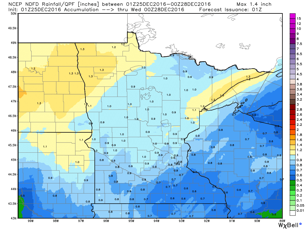
Total Precipitation
The total precipitation from the storm system will exceed 1" liquid across parts the Dakotas and northwest Minnesota, where the heaviest snow (8" to 14") will be found. There will also be some 1"+ liquid tallies across Minnesota's North Shore with a mixture of rain, freezing rain and snow. The Twin Cities and parts of southern Minnesota will likely see up to 1" or less of total liquid through 6pm Monday, but that could be just enough to push the Twin Cities over the edge when it comes to the wettest year on record!!
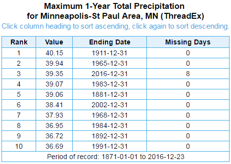
Wettest Years on Record in Minneapolis
Here are the wettest years on record in the Twin Cities. Note that thru December 24th, 39.35" of precipitation has fallen making it the 3rd wettest year on record! We are only 0.80" away from the wettest year set in 1911. With this next storm system moving thru, there is a good chance that we could move into THE wettest spot as up to 1" of total precipitation can't be rule out through Monday... Stay tuned!
_________________________________________________________________________
Dreaming of an Icy, Rain-Swept Christmas?
"If this was an average December we'd be looking at 10 inches of snow on Christmas Day!" a friend lamented. True. And if I was 6 foot 10 inches and reasonably coordinated I'd be playing in the NBA. "Don't fixate on what could have been. Focus on what is in front of you - and how you can make it better" my late mother advised.
ECMWF (European) guidance pulls the mercury into the upper 40s today with southeast winds howling over 40 mph. More tropical storm than winter storm. Rain will freeze on contact with cold surfaces for a time this morning; melting snow clogging drains and flooding roads later today. Ice Storm Warnings are posted from St. Cloud to Brainerd for treacherous travel conditions.
Sunday's powerful storm tracks from Denver to Fargo, keeping us on the warm, rainy side of the low pressure system. By the time it's cold enough for snow - moisture cuts off on gusty northwest winds; little more than flurries on Monday. Models hint at another arctic swipe in a week; subzero lows and single digit highs on New Year's Day? For now soak up family and friends. And stay indoors!
_____________________________________________________________________________
_____________________________________________________________________________
Extended Forecast
CHRISTMAS EVE NIGHT: Patchy freezing drizzle develops late. Winds: ESE 5-10. Low: 29
CHRISTMAS DAY: Icy start. Gusty, heavier PM rain with thunder. Winds: SE 20-40. High: 43
CHRISTMAS DAY: Icy start. Gusty, heavier PM rain with thunder. Winds: SE 20-40. High: 43
CHRISTMAS DAY NIGHT: Rain and thunder ends early, then mostly cloudy and windy. Winds: ESE 20-40. Low: 29.
MONDAY: Gusty winds, flurries taper with falling temperatures. Winds: W 20-40+ High: 31
TUESDAY: The sun comes out, winds ease. Winds: W 8-13. Wake-up: 18. High: 32
WEDNESDAY: Clouds increase, milder. Winds: SW 10-20. Wake-up: 23. High: 40
THURSDAY: Scrappy clouds and flurries. Winds: NW 15-25. Wake-up: 25. High: 30
FRIDAY: Partly sunny skies, good travel. Winds: S 8-13. Wake-up: 19. High: 32
WEDNESDAY: Clouds increase, milder. Winds: SW 10-20. Wake-up: 23. High: 40
THURSDAY: Scrappy clouds and flurries. Winds: NW 15-25. Wake-up: 25. High: 30
FRIDAY: Partly sunny skies, good travel. Winds: S 8-13. Wake-up: 19. High: 32
NEW YEARS EVE: Clipper arrives: flurries & gusty winds. Winds: NW 15-30. Wake-up: 25. High: 27.
_________________________________________________________________________
_________________________________________________________________________
This Day in Weather History
December 25th
1999: Strong winds resulted in a one hundred thirty foot radio tower to collapse in Milaca. No wind measurements were available in the city of Milaca. However, Princeton airport (Mille Lacs county), had a gust to 45 mph at 10:35 pm CST. St. Cloud airport (Stearns County), had a gust to 44 mph at 8:52 pm CST. Mora (Kanabec county) had a gust to 55 mph at 9:35 pm CST, and a gust to 47 mph at 10:35 pm CST.
1996: A strong low pressure system which deposited heavy snow over much of Minnesota on the 23rd, pulled extremely cold Canadian air southward over Minnesota. The cold remained entrenched through the 26th. Temperatures fell to 15 to 35 degrees below zero Christmas Day morning. The Twin Cities and St. Cloud set new record low temperatures both days. In addition, the high temperature on Christmas Day in the Twin Cities was only 9 degrees below zero. Combined with the record low temperature that morning of 22 below, the mean temperature for Christmas Day was 16 degrees below zero. This Christmas Day set a new record for being the coldest day on record for the Twin Cities metro area, going back to the year 1890 when modern day records began.
1922: People are golfing on Christmas in the Twin Cities as temperatures reach the 50s.
_______________________________________________________________________________
Average High/Low for the Twin Cities
December 25th
Average High: 25F (Record: 51F set in 1922)
Average Low: 10F (Record: -39F set in 1979)
Wettest Christmas Day: 1.35" set in 1982
Snowiest Christmas Day: 9.6" set in 1945
________________________________________________________________________________
Sunrise Sunset Times for Minneapolis
December 25th
Sunrise: 7:49am
Sunset: 4:37pm
*Daylight Gained Since Yesterday: ~18 seconds
*Daylight Gained Since Winter Solstice (December 21st): ~45 seconds
_________________________________________________________________________________
Moon Phase for December 25th at Midnight
3.0 Days Before New Moon
 _________________________________________________________________________________
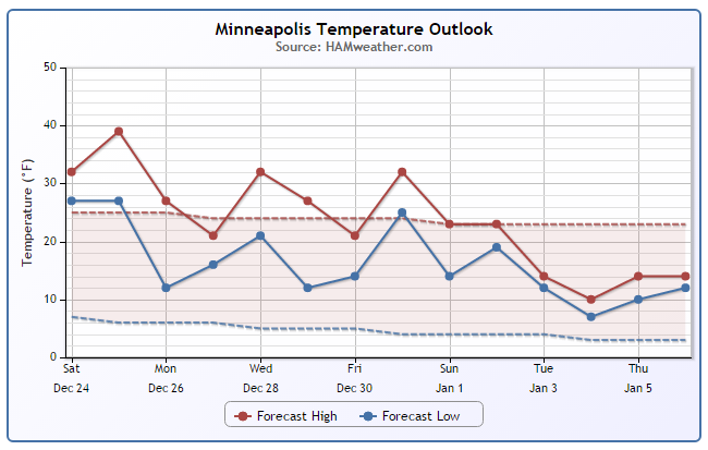
Extended Outlook
After an extremely warm Christmas Day (near 40F) temps will take a bit of a tumble this week. Daytime highs on Tuesday will be closer to if not slightly below average with a couple mild days sprinkled in there through the end of the week. Note that there appears to be a bigger cool down as we head into the first week of 2017.
___________________________________________________________________________
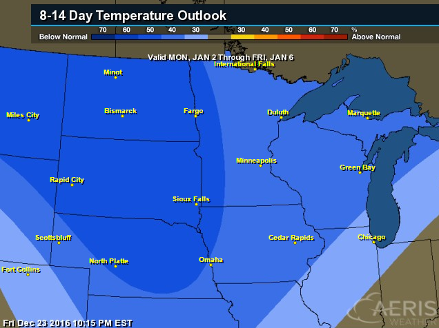
6 to 10 Day Temperature Outlook
According to NOAA's CPC, the 8 to 14 day (January 2nd - 6th) temperature outlook suggests colder than average temperatures returning as we head into early January. We've certainly had wild temp swings as of late... it appears that there will be more on the way.
____________________________________________________________________________
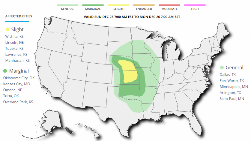
Severe Wind Risk on Christmas Day...
According to NOAA SPC, there is a risk of severe weather in the Central US on Sunday, December 25th (Christmas Day). Note that the best chance for severe storms will be found across parts of Nebraska and Kansas. The SPC is highlighting a severe-wind risk as the main threat starting as early as mid/late morning and continuing into the afternoon hours. The severe threat will lessen as we head into the evening hours. Note that there is a general thunder risk as far north as the Minneapolis/St. Paul area, where thunderstorms in December are rare and Christmas Day thunderstorms are even more rare!
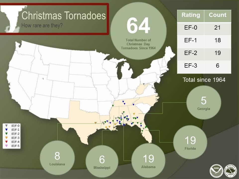
How Rare Are Tornadoes on Christmas Day?
Here's a neat image from the NWS, which shows how rare tornadoes are on Christmas Day. Note that since 1964, there have only been 64 tornadoes, most of which have occurred along the Gulf Coast, where tropical moisture is a little more accessible at this time of the year. However, note that there was one tornado reported as far north as West Virginia! A majority of the tornadoes at this time of the year tend to be 'weaker', but 25 of which have been rated EF-2 or EF-3.
________________________________________________________________________________
Christmas Day Blizzard and Severe Storms. Quiet Midweek, Then More Active by New Years
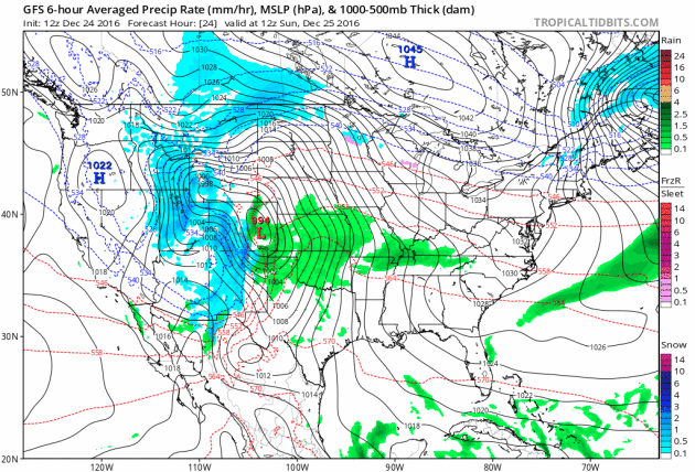
Here's the national weather outlook from Sunday, December 25th (Christmas Day) to Sunday, January 1st (New Years Day). Note the very large storm system moving through the Central US on Christmas day with widespread impacts lingering into early next week. Weather conditions will calm down a little through much of the rest of the week, but another (weaker) storm system looks to develop across the Central US again by next weekend.
 _________________________________________________________________________________
Warm Christmas Day in the Central US
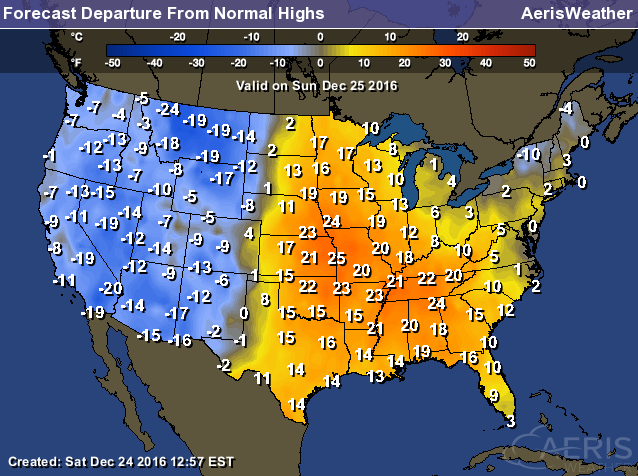
WOW! How about this for a highs from average map! As our storm system moves into the Central US on Christmas Day, highs across the Central US will be near 20F to 25F above average, while folks in the Western US will be nearly 10F to 20F below average in the wake of the storm system. This clash in temperatures is part of the reason why the storm system will be so intense on Christmas Day.
Soggy Southwest
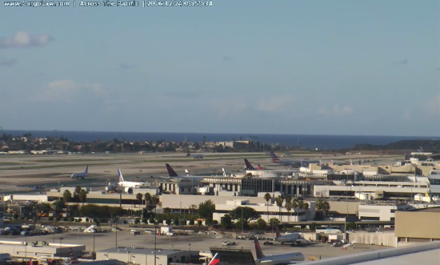
Here's the view from the Los Angeles International Airport (LAX) from early Christmas Eve morning. It was a chilly, but drier start to the day. Prior to that, it had been a very wet end of the week with LAX seeing 1.70" of rain since Wednesday. 0.96" of that fell on Friday, good enough for a daily rainfall record. Downtown Los Angeles recorded 2.18" of rain since Wednesday! According to the NWS in Los Angeles, there has been 4.08" of rain in downtown los Angeles making it the wettest December since 2010 when 10.23" fell.
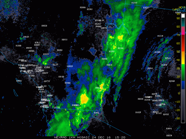
 Heavy Rain in the Southwest
Take a look at the radar from midday Saturday as heavier rain moved from southern California to western Arizona. Saturday into Sunday will be wet across these areas as the storm system moves east through the region.
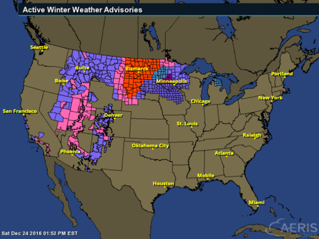
 Widespread Wintry Weather
Take a look at all the winter weather headlines that have been posted by the NWS. Areas of heavy snow will be found from the Southwest to the Midwest with the most significant impacts being felt across the Dakotas where Blizzard Warnings have been posted! 8" to 14" of snow and 50mph+ wind gusts can't be ruled out. Major roadways will likely be shut down as the storm unfolds over the area.
 Snowfall Potential
Here's a look at snowfall through early next week as the storm system moves northeast. Note that the most widespread and heaviest snowfall appears to fall from near the Black Hills of South Dakota through much of central and eastern North Dakota into far northwestern Minnesota.
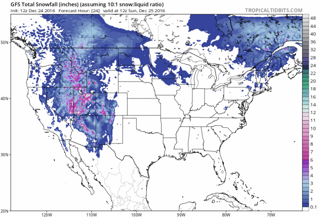 Heavy Snow in the Midwest
Here's the snowfall potential through early next week, which shows a heavy band of of near 8" to 14"+ possible from near the Black Hills of South Dakota through much of central and eastern North Dakota into far northwestern MN.
.gif)
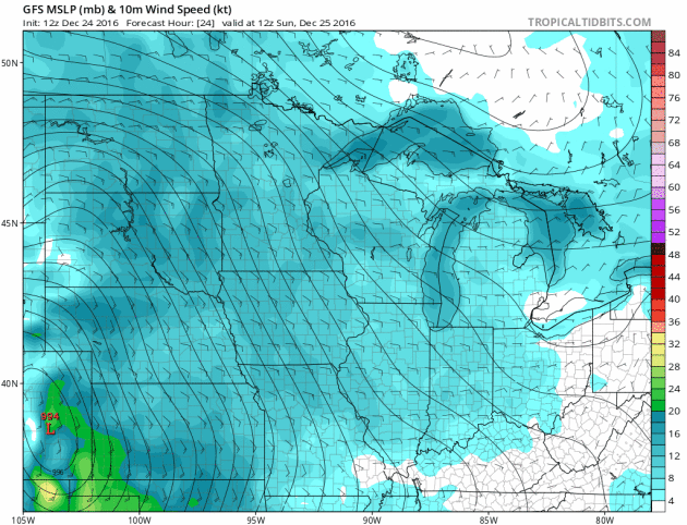
Intense Winds
Winds surrounding this intense storm system will be quite impressive! Note the widespread green, yellow and red colors that develops around the center of the storm system. Sustained winds in many locations will range from 20mph-40mph; wind gusts could be as high as 50mph-60mph in a few locations!
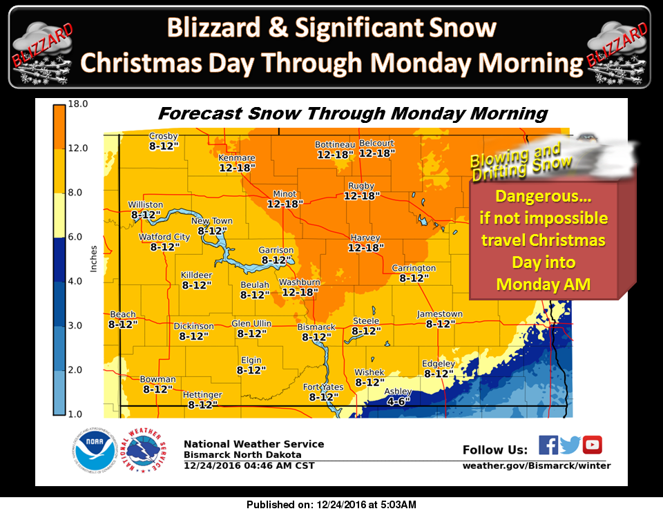
 Dangerous Storm Across North Dakota Sunday into Monday
Here's the Weather Story from the NWS out of Bismarck, ND, which suggests very heavy snowfall and significant winds across much of the state. The NWS is warning of dangerous if not impossible travel conditions on Christmas Day into AM Monday. Here's an excerpt of the BLIZZARD WARNING that the NWS has issued for much of the state:
A POWERFUL WINTER STORM WILL HARSHLY IMPACT WESTERN AND CENTRAL NORTH DAKOTA...AND ADJACENT AREAS OF THE NORTHERN PLAINS AND CANADIAN PRAIRIE PROVINCES...WITH HEAVY SNOW AND STRONG WINDS. THE BLIZZARD WILL PRODUCE WIDESPREAD SNOW AMOUNTS OF 8 TO 12 INCHES... WITH SOME 15 INCH AMOUNTS. WIND GUSTS AS HIGH AS 55 MPH WILL RESULT IN VERY DANGEROUS IF NOT IMPOSSIBLE TRAVEL. SOME ROADS COULD BECOME BLOCKED BY DRIFTING SNOW. IF YOU HAVE TRAVEL PLANS SUNDAY OR MONDAY...CONSIDER CHANGING THEM.
________________________________________________________________________
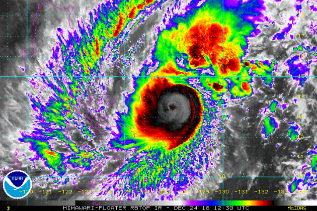
Super Typhoon Nock-Ten
In the western part of the Pacific Ocean, folks in the Philippines are bracing for a very strong typhoon. As of midday Saturday, sustained winds were forecast to be near 150mph with winds gusts up to 180mph! Nock-ten is forecast to pass directly over Manila as a category 1 or category 2 typhoon with rainfall tallies up to 10", which may cause widespread damage and flooding on Christmas Day.
 ______________________________________________________________________________
Thanks for checking in and have a good Christmas and last week of 2016!
Follow me on Twitter @TNelsonWX

1922: People are golfing on Christmas in the Twin Cities as temperatures reach the 50s.
_______________________________________________________________________________
Average High/Low for the Twin Cities
December 25th
Average High: 25F (Record: 51F set in 1922)
Average Low: 10F (Record: -39F set in 1979)
Wettest Christmas Day: 1.35" set in 1982
Snowiest Christmas Day: 9.6" set in 1945
________________________________________________________________________________
Sunrise Sunset Times for Minneapolis
December 25th
Sunrise: 7:49am
Sunset: 4:37pm
*Daylight Gained Since Yesterday: ~18 seconds
*Daylight Gained Since Winter Solstice (December 21st): ~45 seconds
_________________________________________________________________________________
Moon Phase for December 25th at Midnight
3.0 Days Before New Moon
Extended Outlook
After an extremely warm Christmas Day (near 40F) temps will take a bit of a tumble this week. Daytime highs on Tuesday will be closer to if not slightly below average with a couple mild days sprinkled in there through the end of the week. Note that there appears to be a bigger cool down as we head into the first week of 2017.
___________________________________________________________________________
6 to 10 Day Temperature Outlook
According to NOAA's CPC, the 8 to 14 day (January 2nd - 6th) temperature outlook suggests colder than average temperatures returning as we head into early January. We've certainly had wild temp swings as of late... it appears that there will be more on the way.
____________________________________________________________________________
Severe Wind Risk on Christmas Day...
According to NOAA SPC, there is a risk of severe weather in the Central US on Sunday, December 25th (Christmas Day). Note that the best chance for severe storms will be found across parts of Nebraska and Kansas. The SPC is highlighting a severe-wind risk as the main threat starting as early as mid/late morning and continuing into the afternoon hours. The severe threat will lessen as we head into the evening hours. Note that there is a general thunder risk as far north as the Minneapolis/St. Paul area, where thunderstorms in December are rare and Christmas Day thunderstorms are even more rare!
How Rare Are Tornadoes on Christmas Day?
Here's a neat image from the NWS, which shows how rare tornadoes are on Christmas Day. Note that since 1964, there have only been 64 tornadoes, most of which have occurred along the Gulf Coast, where tropical moisture is a little more accessible at this time of the year. However, note that there was one tornado reported as far north as West Virginia! A majority of the tornadoes at this time of the year tend to be 'weaker', but 25 of which have been rated EF-2 or EF-3.
________________________________________________________________________________
Christmas Day Blizzard and Severe Storms. Quiet Midweek, Then More Active by New Years
Here's the national weather outlook from Sunday, December 25th (Christmas Day) to Sunday, January 1st (New Years Day). Note the very large storm system moving through the Central US on Christmas day with widespread impacts lingering into early next week. Weather conditions will calm down a little through much of the rest of the week, but another (weaker) storm system looks to develop across the Central US again by next weekend.
Warm Christmas Day in the Central US
WOW! How about this for a highs from average map! As our storm system moves into the Central US on Christmas Day, highs across the Central US will be near 20F to 25F above average, while folks in the Western US will be nearly 10F to 20F below average in the wake of the storm system. This clash in temperatures is part of the reason why the storm system will be so intense on Christmas Day.
Soggy Southwest
Here's the view from the Los Angeles International Airport (LAX) from early Christmas Eve morning. It was a chilly, but drier start to the day. Prior to that, it had been a very wet end of the week with LAX seeing 1.70" of rain since Wednesday. 0.96" of that fell on Friday, good enough for a daily rainfall record. Downtown Los Angeles recorded 2.18" of rain since Wednesday! According to the NWS in Los Angeles, there has been 4.08" of rain in downtown los Angeles making it the wettest December since 2010 when 10.23" fell.
Take a look at the radar from midday Saturday as heavier rain moved from southern California to western Arizona. Saturday into Sunday will be wet across these areas as the storm system moves east through the region.
Take a look at all the winter weather headlines that have been posted by the NWS. Areas of heavy snow will be found from the Southwest to the Midwest with the most significant impacts being felt across the Dakotas where Blizzard Warnings have been posted! 8" to 14" of snow and 50mph+ wind gusts can't be ruled out. Major roadways will likely be shut down as the storm unfolds over the area.
Here's a look at snowfall through early next week as the storm system moves northeast. Note that the most widespread and heaviest snowfall appears to fall from near the Black Hills of South Dakota through much of central and eastern North Dakota into far northwestern Minnesota.
Here's the snowfall potential through early next week, which shows a heavy band of of near 8" to 14"+ possible from near the Black Hills of South Dakota through much of central and eastern North Dakota into far northwestern MN.
Intense Winds
Winds surrounding this intense storm system will be quite impressive! Note the widespread green, yellow and red colors that develops around the center of the storm system. Sustained winds in many locations will range from 20mph-40mph; wind gusts could be as high as 50mph-60mph in a few locations!
Here's the Weather Story from the NWS out of Bismarck, ND, which suggests very heavy snowfall and significant winds across much of the state. The NWS is warning of dangerous if not impossible travel conditions on Christmas Day into AM Monday. Here's an excerpt of the BLIZZARD WARNING that the NWS has issued for much of the state:
A POWERFUL WINTER STORM WILL HARSHLY IMPACT WESTERN AND CENTRAL NORTH DAKOTA...AND ADJACENT AREAS OF THE NORTHERN PLAINS AND CANADIAN PRAIRIE PROVINCES...WITH HEAVY SNOW AND STRONG WINDS. THE BLIZZARD WILL PRODUCE WIDESPREAD SNOW AMOUNTS OF 8 TO 12 INCHES... WITH SOME 15 INCH AMOUNTS. WIND GUSTS AS HIGH AS 55 MPH WILL RESULT IN VERY DANGEROUS IF NOT IMPOSSIBLE TRAVEL. SOME ROADS COULD BECOME BLOCKED BY DRIFTING SNOW. IF YOU HAVE TRAVEL PLANS SUNDAY OR MONDAY...CONSIDER CHANGING THEM.
________________________________________________________________________
Super Typhoon Nock-Ten
In the western part of the Pacific Ocean, folks in the Philippines are bracing for a very strong typhoon. As of midday Saturday, sustained winds were forecast to be near 150mph with winds gusts up to 180mph! Nock-ten is forecast to pass directly over Manila as a category 1 or category 2 typhoon with rainfall tallies up to 10", which may cause widespread damage and flooding on Christmas Day.
_______________________________________________________________________________
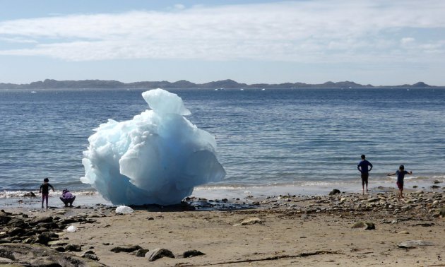
"The country set to cash in on climate change"
"Record temperatures threaten traditional ways of life in Greenland but as the sea ice retreats, new mining, fishing and tourism opportunities are helping communities to adapt. Greenland has lived with extreme environmental changes for a decade or more. Sea ice is forming two months later and melting one month earlier. Rivers fed by retreating glaciers are at record levels. And temperature records were smashed twice this year, with stunned meteorologists rechecking their measurements after 24C was recorded in the capital, Nuuk, in June. Traditional hunters are giving up their dog teams because there is three months less hunting on sea ice but climate change is “no disaster”, according to Berthelsen, the deputy manager of Knapk, Greenland’s hunters and fishers’ association. The 56,000 inhabitants of the largest island in the world that is not a continent must adapt, fast.
(Children play next to an iceberg on the beach in Nuuk, where temperatures of 24C stunned meteorologists in June 2016. Photograph: Alister Doyle/Reuters)
Thanks for checking in and have a good Christmas and last week of 2016!
Follow me on Twitter @TNelsonWX
No comments:
Post a Comment