37 F. high temperature in the Twin Cities yesterday (yes, the ECMWF model was out to lunch).
25 F. average high on December 25.
30 F. high on December 25, 2015.
December 26, 1990: Much of central Minnesota sets record low temperatures near 30 degrees below zero, while others had lows in the teens below zero. Cambridge had the coldest temperature with 31 below. Mora was close behind, with a low of 30 below. Other notably cold lows were at St. Cloud, with 29 below, and Melrose and Menomonie, WI with 27 below.
Words To Live By: "Don't Push The Weather"
It's halftime at the Oreo Classic Tooth Decay Bowl, so let me tell you a quick story.
My youngest son is a Lieutenant in the U.S. Navy. He's a HAC, a Helicopter Aircraft Commander in the Pacific. He calls me up every now and then for a quick forecast. For years I've been telling him not to push the weather. Want to live long enough to see grandkids? Be perpetually paranoid about the weather.
On Christmas Eve we all drove up to our cabin near Nisswa. I dialed up the computer models and decided to turn around and return to the Twin Cities 10 hours later; not risk driving into an ice storm Christmas Day.
Yesterday was an icy mess across central Minnesota; front-wheel or all-wheel drive no help on glaze ice.
Expect colder winds today (gusting to 40) with falling temperatures; no more than a candy-coating of flurries. I don't see any big storms this week but a weak clipper may brush us with a coating of snow New Year's Eve. Expect 20s and a few 30s this week - models hinting at a subzero swipe by the middle of next week.
Remember, the next 3 weeks are, on average, the coldest of the winter.
Real-time travel conditions for the Upper Midwest courtesy of the University of Wisconsin.

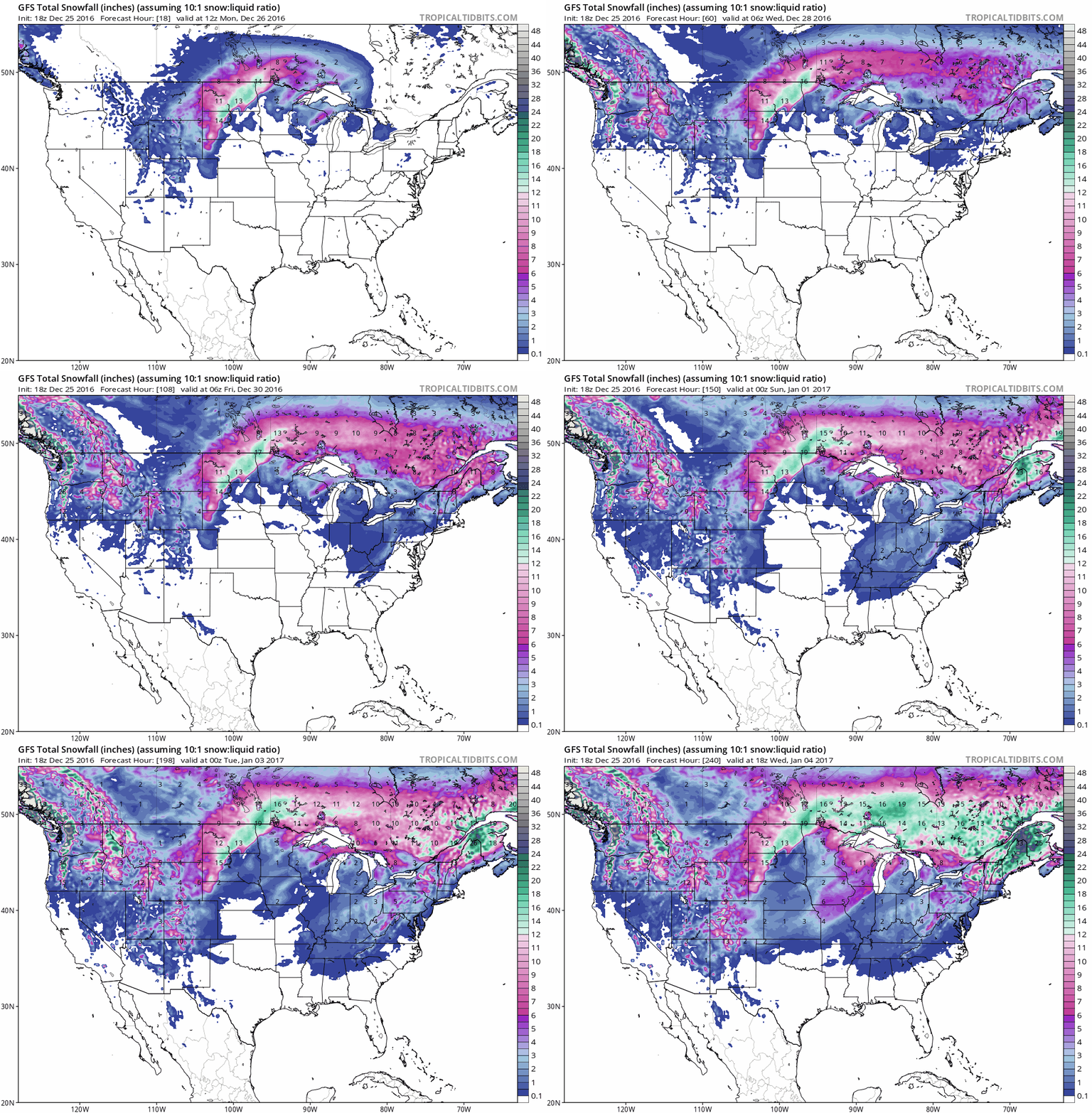
10-Day Snowfall Potential. Blizzard conditions ease over the Dakotas and the Red River Valley of Minnesota later today, GFS guidance shows snow pushing into the Mid South and Mid Atlantic region by next weekend with a fresh shot of arctic air; some 12"+ snowfall amounts predicted for central and northern New England between now and early next week. Source: Tropicaltidbits.com.

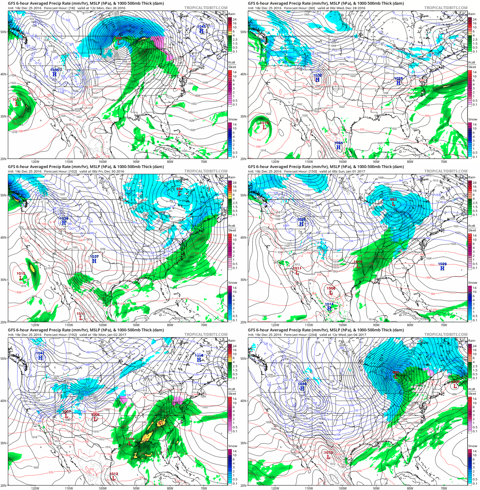
Another Subzero Swipe Next Week? The same GFS model shows a clipper-like system spreading light snow across the northern tier of the USA next weekend, sparking icy roads from the Twin Cities to Milwaukee, Detroit and Syracuse. A shot of subzero air may push across the Plains into the Midwest by the middle of next week.
Above Average Into New Year's Weekend.
The average high now is in the mid-20s; ECMWF-predicted high
temperatures climb into the 20s and 30s through New Year's Day in the
Twin Cities, followed by a sharp drop in temperature next week.
Numbing Second Week of January Midwest into New England and Mid Atlantic.
Relatively mild weather is predicted for much of the western and
southern USA (consistent with a La Nina pattern) but a few days and
nights of subzero weather are likely from the Twin Cities and Chicago to
Pittsburgh, Albany and Boston.
Arctic Temperatures Soar to 30C Above Normal. That's close to 50F warmer than average. No, this isn't normal or "average". And what happens in the Arctic doesn't stay in the Arctic. Here's an excerpt from Canada's CBC: "...In fact, models — which Scambos says are "fairly generous" — anticipate an ice-free Arctic by the 2050s or 2060s, though it could happen sooner. "There's an inertia to the climate system," Scambos said. "We still are not seeing the world we're in for." David Phillips, senior climatologist with Environment and Climate Change Canada , said that instead of the air flow moving west to east, as it typically does, patterns are changing. Now there is more of a north-south interaction where warm air moves up from the south. However, the northern air can also dip further down, as we saw the past two weeks with unusually cold temperatures across the country. The change in air flow can cause the wild swings we are seeing more often. In this case, warm air over Greenland and Norway is being pulled up to the Arctic, causing the unusual weather..."
Photo credit: "The Arctic climate is changing, alarming climatologists." (CBC)
Image credit: "Temperature near 89N latitude Dec. 20-22. (Data from North Pole Environmental Observatory buoy 300234064010010"
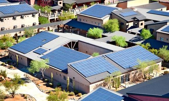
Xcel Energy Flips Switch on New Plant, More Than Doubling Minnesota Solar Energy Generation. Here's an excerpt from Star Tribune: "After
years of talking and planning, solar energy in Minnesota is finally
starting to shine. Xcel Energy last week flipped the switch on the North
Star project in Chisago County, one of the largest solar plants in the
Midwest. It by itself more than doubles the state’s total solar energy
generation. Also this month, Xcel’s promising but much-delayed Community
Solar Garden program is rolling out in a significant way. Around 20
megawatts of solar garden power are online, and up to 35 more megawatts
are expected to be running by Jan. 1. Another large project that will
feed power to Xcel — called Aurora — has been largely energized since
mid-November..."
Photo credit: Brian Peterson, Star Tribune.

2 Remarkable Facts That Illustrate Solar Power's Declining Cost. Dave Roberts has an eye-opening post at Vox: "...Our
second remarkable fact is tucked away there on row five: Cutting edge
solar has nosed ahead of natural gas. Specifically, utility-scale,
thin-film solar PV plants produce cheaper power, on average, than new
natural gas plants. (“Thin-film” solar involves advanced materials other
than crystalline silicon, which has been the standard material for
solar panels for most of the history of solar.) Both onshore wind and
solar PV have seen insane drops in cost over the past eight years — 66
and 85 percent, respectively..."
File photo: Solar City.
Your Future Commute: Flying Through Tubes at 760 mph. Not quite flying cars, but we're getting closer, according to The Washington Post: "Picture
the commute of the future: You live in Palo Alto, Calif., but work 350
miles away in Los Angeles. After your morning latte, you click on a
smartphone app to summon your digital chauffeur. An autonomous car shows
up at your front door three minutes later to drive you to a Hyperloop
station in downtown Mountain View, where a pod then transports you
through a vacuum tube at 760 mph. When you reach the Pasadena station,
another self-driving car awaits to take you to your office. You reach
your destination in less than an hour. That is the type of scenario that
Hyperloop Transportation Technologies (HTT)
chief executive Dirk Ahlborn laid out for me as we were preparing to
speak together on a panel at the Knowledge Summit in Dubai on Dec. 5..."
7 of the 10 Drunkest Cities in America Are All In a Single State. Oh really? Foodandwine.com has the story: "Around
here we like good beer, we like good wine, we like good cocktails, and
we certainly have had occasion to drink a few too many of those things.
But imbibing to excess is a serious matter and the list released over
the weekend from 24/7 Wall Street and
compiled using data from the Robert Wood Johnson Foundation and
University of Wisconsin Population Health Institute isn’t a top 10
anyone necessarily wants to be a part of. What that data showed was that
7 of the top 10 and 12 of the top 20 cities most inclined to binge are
in the state of Wisconsin..."
20 of the Prettiest Holiday Light Displays In The World. The Washington Post has the photo essay. Credit: "People
are silhouetted as they walk through a light installation titled
"Universal Journey" composed of 824,961 light bulbs at the Universal
Studios in Singapore." Wong Maye-E/AP.
TODAY: Gusty, dusting of flakes. Winds: W 20-40+ High: 33
MONDAY NIGHT: Flurries taper, still windy. Low: 17
TUESDAY: Some sun, seasonably cool. Winds: W 8-13. High: 28
WEDNESDAY: Mostly cloudy, temporary thaw. Winds: W 10-20. Wake-up: 16. High: 34
THURSDAY: Cold and gray, flurries likely. Wake-up: 25. High: near 30 (falling)
FRIDAY: Rare sunshine sighting, a bit milder. Winds: SE 5-10. Wake-up: 21. High: 33
NEW YEAR'S EVE: Next clipper: coating of snow? Winds: E 8-13. Wake-up: 26. High: 31
NEW YEAR'S DAY: Mostly cloudy, quiet start to 2017. Winds: SW 8-13. Wake-up: 22. High: 32
* My thanks to KSTP and Channel 45 for the Yule Log stream. Can you keep it up year-round?
Climate Stories...
Still So Much Confusion About Weather vs. Climate. Weather is an argument, climate is an entire marriage. Here's an excerpt from Summit County Citizens Voice: "...The study found that Americans who experience more record highs than lows in temperature are more likely to believe the earth is warming. Conversely, Americans who live in areas that have experienced record low temperatures, such as southern portions of Ohio and the Mississippi River basins, are more skeptical that the earth is warming. According to the study, the language of climate communications may be key, with the phrase ‘global warming’ resulting in a cognitive disconnect. That term might have led residents living in areas that experienced an unusually cold winter to doubt that climate change is occurring. “Who do Americans trust about climate change; scientists or themselves?” said Robert Kaufmann, professor in the department of geography and the Center for Energy & Environmental Studies at Boston University and lead author of the paper. “For many Americans, the answer seems to be themselves.” The researchers also found that a recent period of lower-than-average temperatures offset the effect of a long warming period, further supporting their findings that people’s belief in climate change is local and experiential..."
Photo credit: "If it’s hot, it’s global warming, but if not …" @bberwyn photo.

Guest Opinion: Meteorologists Caught Up in Climate Debate. Here's an excerpt of an Op-Ed that resonated from a meteorologist at Mail Tribune in Medford, Oregon: "...There is no massive conspiracy to create and maintain a global warming scare. Hundreds of mature, dedicated, sincere meteorological scientists have worked hard during their entire careers to advance climate science and develop the best predictions. Their work has been critically reviewed for decades by hundreds of their peers - independent scientists - in the domain of open scientific literature. Best available data and computer predictions now indicate that the human race has become capable of inadvertently affecting the global climate. That effect is already apparent, and is now superimposed on natural climate changes that continue to occur. The new global climate will have some destructive characteristics for humans. Our problem now is that human society was constructed to be consistent with the climate of the last few thousand years. The new climate will be different..."
Photo credit: "Scientists hold signs during a rally in conjunction with the American Geophysical Union's fall meeting Tuesday, Dec. 13, 2016, in San Francisco." (AP Photo/Marcio Jose Sanchez).
Photo credit: Bethany Legg via Unsplash.
Photo credit: "The energy system and the tax system have got to be simplified in a way that everybody understands and doesn’t allow the wealthy few to completely rig the system," says Hansen." Benedict Evans/Redux.
No comments:
Post a Comment